Location
Latitude: |
38-51-05.1850N (38.85144) |
Longitude: |
077-02-15.7970W (-77.037721) |
Elevation: |
14.1 feet MSL (4 m MSL) |
Magnetic Variation: |
10.7 W (as of April 2024 from WMM2020 model) |
Time Zone: |
UTC -5.0 (Standard Time) UTC -4.0 (Daylight Savings Time) |
From City: |
03 N.M. S of Washington, Dist. Of Columbia |
Found On: |
Washington Chart |
FAA Region: |
AEA |
Contacts
Manager: |
Publicly owned: |
| PAUL MALANDRINO, JR. 1 AVIATION CIRCLE WASHINGTON, DC 20001-6000 703-417-8050 |
METRO WASH ARPT AUTHORITY 1 AVIATION CIRCLE WASHINGTON, DC 20001-6000 703-417-8600 |
Operations
Airport Status: |
Operational |
Facility Use: |
Public |
Type: |
Airport |
Activation Date: |
03/1941 |
Control tower: |
Yes |
Attendance (Months/Days/Hours): |
Months/Days/Hours ALL/ALL/ALL |
Boundary ARTCC: |
ZDC (Washington) |
Responsible ARTCC: |
ZDC (Washington) |
Segmented Circle Indicator: |
No |
Traffic Pattern Altitude (MSL): |
1014 feet (309 m) |
NOTAMs Facility: |
DCA |
NOTAM-D Service: |
Yes |
International Airport of Entry: |
No |
Customs Landing Rights: |
Yes |
Military Landing Rights: |
No |
Civil/Military Joint Use: |
No |
Aircraft Rescue and Firefighting: |
Class I ARFF Index: C Air Carrier Service: Scheduled Certification Date: 05/1973 |
Based Aircraft
Annual Operations (as of 02/28/2023)
| Total Operations: | 297445 | |
| Commercial: | 294410 | 99.0% |
| Air Taxi: | 85 | 0.0% |
| GA Itinerant: | 1928 | 0.6% |
| Military Aircraft: | 1022 | 0.3% |
Communications
| Unicom: | 122.950 |
| Tower: | WASHINGTON 119.1 134.35 ;HELICOPTERS 257.6 Hrs: 24 |
| Ground: | 121.7 257.6 |
| Approach: | POTOMAC |
| Departure: | POTOMAC |
| ATIS: | 132.65 Hrs: 24 |
| ASOS: | 132.65 (703-418-1177) |
| EMERG: | 121.5 |
| EMERG: | 243.0 |
- ARRIVALS MAY BE EXTENDED OUTSIDE OF CLASS B.
Fixed Based Operators (FBOs) & Fuel
(Click on a business for detail)
Please help us keep this information up to date. This is a FREE SERVICE just like everything else on Airport Guide! If you see that a business needs to be added, modified, or deleted please fill out our Update Form.
To add, modify, or delete a business click here.
Please help us keep this information up to date. This is a FREE SERVICE just like everything else on Airport Guide! If you see that a business needs to be added, modified, or deleted please fill out our Update Form.
Area Code: 703 |
| Business Name | Frequency | Phone | Fuel Grade |
|---|---|---|---|
| Martin Air Charter
Update FBO info |
419-5400, 702-1480, 800-777-7401 | ||
| Signature Flight Support
Website Update FBO info |
Unicom: 122.95, Arinc: 130.425 | +1 703 417 3500 | 100LL, Jet A |
Flight Service Stations
| Primary | Alternate | |
| FSS on Field: | N | |
| FSS Name (ID): | Leesburg(DCA) | |
| Frequency: | ||
| Toll Free Phone: | 1-800-WX-BRIEF |
Instrument Procedures / Charts
FAA Terminal Procedures valid from 0901Z 03/21/24 to 0901Z 04/18/24.
There are various types of charts available for an airport. They are listed in the Page Type column. Here is a legend for those types:
APD - Airport Diagram
DP - Departure Procedure Charts
HOT - Hot Spots
IAP - Instrument Approach Procedure Charts
MIN - Minimums
STAR - Standard Terminal Arrival Charts
Terminal Procedures are only available for airports in several countries with more being added all the time. If you are looking for a specific country's charts, please send an email to support(at)airportguide.com stating the country name. This will be used to prioritize the implementation.
Navigation Aids (Navaids) near DCA
| Dist (NM) | ID | Morse Code | Name | Type | Freq | True Hdg | Mag Hdg |
|---|---|---|---|---|---|---|---|
| 0.5 | DCA | _ . . _ . _ . . _ | Washington | VOR-DME | 111.00 | 7 | 18 |
| 5.2 | DCA | _ . . _ . _ . . _ | Oxonn | NDB | 332 | 174 | 185 |
| 6.2 | GTN | _ _ . _ _ . | Georgetown | NDB | 323 | 319 | 330 |
| 8.0 | ADW | . _ _ . . . _ _ | Andrews Afb | VOT | 109.60 | 110 | 121 |
| 8.4 | ADW | . _ _ . . . _ _ | Andrews | VORTAC | 113.10 | 108 | 119 |
| 11.9 | DAA | _ . . . _ . _ | Davee | NDB | 223 | 196 | 207 |
| 16.3 | OTT | _ _ _ _ _ | Nottingham | VORTAC | 113.70 | 122 | 133 |
| 19.0 | BUH | _ . . . . . _ . . . . | Anne Arundel | NDB | 260 | 42 | 53 |
| 20.0 | GAI | _ _ . . _ . . | Gaithersburg | NDB | 385 | 342 | 353 |
| 20.6 | AML | . _ _ _ . _ . . | Armel | VOR-DME | 113.50 | 284 | 295 |
| 26.0 | BAL | _ . . . . _ . _ . . | Baltimore | VORTAC | 115.10 | 42 | 53 |
| 28.8 | FND | . . _ . _ . _ . . | Ellicott | NDB | 371 | 24 | 35 |
| 32.4 | IUB | . . . . _ _ . . . | Institute | NDB | 404 | 36 | 47 |
| 34.3 | BRV | _ . . . . _ . . . . _ | Brooke | VORTAC | 114.50 | 205 | 216 |
| 37.1 | FDK | . . _ . _ . . _ . _ | Frederick | VOR | 109.00 | 335 | 346 |
| 37.6 | GDX | _ _ . _ . . _ . . _ | Goodwin Lake | NDB | 227 | 279 | 290 |
| 38.7 | EMI | . _ _ . . | Westminster | VORTAC | 117.90 | 4 | 15 |
| 40.1 | EZF | . _ _ . . . . _ . | Shannon | NDB | 237 | 209 | 220 |
| 40.7 | CSN | _ . _ . . . . _ . | Casanova | VORTAC | 116.30 | 252 | 262 |
| 45.1 | NHK | _ . . . . . _ . _ | Patuxent | NDB | 400 | 138 | 149 |
Nearby Airports with Fuel
Notices to Airmen (NOTAMS)
Remarks
| A110-10 | TWY K ENDS AT GATE 5. |
| A110-13 | FLOCKS OF BIRDS ON & INVOF ARPT; FQT GULL & GEESE & DUCK POPULATIONS AB OVER ADJ RIVER AREAS. |
| A110-14 | TRNG FLIGHTS THAT INCLUDE MULTIPLE APCHS AND/OR TOUCH & GO OPNS REQUIRE PRIOR PERMISSION FM THE ARPT MGR. |
| A110-17 | LEFT-HAND TURN-OFFS FROM RWY 33 TO TWY 'K' PROHIBITED. |
| A110-19 | ACFT ARRIVING/DEPARTING THE GA PARKING AREA ARE PROHIBITED FM TAXING BTN ACR PUSHBACK OPNS & THE GATES. |
| A110-21 | BE ADVISED SOME AIRCREWS MISTAKE RWY 15 FOR RWY 19. |
| A110-24 | ASDE-X IN USE. OPERATE TRANSPONDERS WITH ALTITUDE REPORTING MODE AND ADS-B (IF EQUIPPED) ENABLED ON ALL AIRPORT SURFACES. |
| A110-25 | RONALD REAGAN WASHINGTON NATIONAL ARPRT (KDCA) IS AN EMERGENCY USE ONLY FIELD FOR ALL DOD OWNED AND OPERATED ACFT. |
| A110-26 | TWY N BTN APCH END RWY 15 AND TWY K CLSD TO ACFT WINGSPAN MORE THAN 124FT. |
| A110-3 | LGT FM VEHICLE PARKING LOT LCTD 1000 FT SW OF RWY 01 COULD GIVE FALSE INDICATIONS OF BEING PART OF RWY 01 APCH LGT SYS DRG PERIODS OF REDUCED VIS & LOW CEILINGS. |
| A110-5 | FORM 150R CREDIT CARD FOR ALL RQRD SVCS. NO MIL FACS. |
| A30-19X | THIS RWY EXISTS TO SUPPORT THE DCA LDA ASSOCIATED WITH THE ILS. |
| A43-19 | RWY 19 PAPI-4L CONSISTS OF TWO PAPI-4L SYSTEMS. RWY 19 PAPI-4L IS ROTATED 21 DEGS TO RIGHT OF CNTRLN. THE ROTATED PAPI-4L SYSTEM SUPPORTS VISUAL AND INSTR APCHS TO RWY 19. |
| A56-04 | THREE OBSTRUCTION LGTS POLES--ONE 600 FEET LEFT, ONE ON CENTERLINE, ONE 600 FEET RIGHT. |
| A58-15 | RWY 15 +8 FT BLAST FENCE 120 FT FM AER 250 FT RIGHT. |
| A58-19 | +10 FT BLDG (L/M) +120 FT FROM AER 300 FT LEFT. |
| E111 | RWY 06 +53 FT TREES 175 FT R @ THR. |
| E60-04 | ENGINEERED MATERIALS ARRESTING SYSTEM (EMAS) 336 FT IN LENGTH BY 170 FT IN WIDTH LCTD AT THE DER 04. |
| E60-15 | ENGINEERED MATERIALS ARRESTING SYSTEM (EMAS) 142 FT IN LENGTH BY 170 FT IN WIDTH LCTD AT THE DER 15. |
| E60-33 | ENGINEERED MATERIALS ARRESTING SYSTEM (EMAS) 332 FT IN LENGTH BY 170 FT IN WIDTH LCTD AT THE DER 33. |
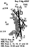
Runways
Runway Summary
| Runways: | 01/19 04/22 15/33 |
| Longest Runway: | 01/19 is 7169 ft (2185 m) long |
| Runways with an Instrument Approach: | 01, 19 |
DCA Airport Runway Details
| Runway 01/19 | 7169 ft x 150 ft (2185 m x 46 m) | |
| Runway Length Source: | 3RD PARTY SURVEY as of 03/15/2013 | |
| Surface: | Asphalt - Good condition - Saw-cut or plastic grooved | |
| Runway Pavement Class: | 57 /F/B/X/T | |
| Runway Edge Lights: | High Intensity | |
Runway Weight Bearing Capacity (in thousands of pounds) |
||
| Single Wheel Landing Gear: | 110.0 | |
| Dual Wheel Landing Gear: | 200.0 | |
| Dual Tandem Wheel Landing Gear: | 360.0 | |
Runway 01 |
Runway 19 |
|
Elevation: |
11.4 | 12.1 |
Latitude: |
38-50-29.6455N | 38-51-40.2933N |
Longitude: |
077-02-12.2944W | 077-02-19.4053W |
|
Runway True Alignment: |
356 | 175 |
ILS Type: |
ILS/DME | LDA/DME |
Glide Path Angle: |
3.0 degrees | 3.0 degrees |
Traffic Pattern: |
Left | Right |
Runway Markings Type: |
Precision Instrument | Precision Instrument |
Runway Markings Condition: |
Good | Good |
Object at End: |
TOWER | TREE |
Object Height: |
180 | 27 |
Object Marked/Lighted?: |
Lighted | |
Distance from End: |
7700 | 990 |
Object Centerline Offset: |
1600 ft. left of centerline | 240 ft. left of centerline |
Visual Glide Slope Indicators: |
4-Light PAPI On Right Side Of Runway | 4-Light PAPI On Left Side Of Runway |
Runway Visual Range (RVR): |
Touchdown, Rollout | Touchdown, Rollout |
Approach Light System: |
Standard 2,400 Foot High Intensity Approach Lighting System With Sequenced Flashers, Cat. II or III Config. | 1,400 Foot Medium Intensity Approach Lighting System With Sequenced Flashers |
REIL: |
No | |
Touchdown Lights: |
Yes | |
Centerline Lights: |
Yes | Yes |
Threshold Crossing Height: |
54 | 50 |
Declared Distances |
||
Take Off Run Avbl. (TORA): |
6869 | 6869 |
Take Off Distance Avbl. (TODA): |
6869 | 6869 |
Actual Stop Dist. Avbl. (ASDA): |
6869 | 6869 |
Landing Dist. Avbl. (LDA): |
6869 | 6869 |
| Runway 04/22 | 5000 ft x 150 ft (1524 m x 46 m) | |
| Runway Length Source: | 3RD PARTY SURVEY as of 03/15/2013 | |
| Surface: | Asphalt - Good condition - Saw-cut or plastic grooved | |
| Runway Pavement Class: | 57 /F/B/X/T | |
| Runway Edge Lights: | Medium Intensity | |
Runway Weight Bearing Capacity (in thousands of pounds) |
||
| Single Wheel Landing Gear: | 110.0 | |
| Dual Wheel Landing Gear: | 200.0 | |
| Dual Tandem Wheel Landing Gear: | 360.0 | |
Runway 04 |
Runway 22 |
|
Elevation: |
11.4 | 11.0 |
Latitude: |
38-50-28.0544N | 38-51-12.6396N |
Longitude: |
077-02-29.2371W | 077-02-01.9708W |
|
Runway True Alignment: |
026 | 206 |
Glide Path Angle: |
3.2 degrees | 3.0 degrees |
Traffic Pattern: |
Left | Right |
Runway Markings Type: |
Nonprecision Instrument | Nonprecision Instrument |
Runway Markings Condition: |
Good | Good |
Arresting Device: |
EMAS | |
Object at End: |
ROAD | GND |
Object Height: |
10 | 2 |
Object Marked/Lighted?: |
Lighted | |
Distance from End: |
400 | 220 |
Object Centerline Offset: |
1600 ft. left of centerline | 240 ft. left of centerline |
Visual Glide Slope Indicators: |
4-Light PAPI On Left Side Of Runway | 4-Light PAPI On Left Side Of Runway |
REIL: |
Yes | Yes |
Threshold Crossing Height: |
52 | 45 |
Threshold Elevation: |
11.8 | |
Displaced Threshold: |
200 | |
Threshold Latitude: |
38-50-29.8369N | |
Threshold Longitude: |
077-02-28.1466W | |
Declared Distances |
||
Take Off Run Avbl. (TORA): |
5000 | 4540 |
Take Off Distance Avbl. (TODA): |
5000 | 4540 |
Actual Stop Dist. Avbl. (ASDA): |
5000 | 4400 |
Landing Dist. Avbl. (LDA): |
4800 | 4400 |
| Runway 15/33 | 5204 ft x 150 ft (1586 m x 46 m) | |
| Runway Length Source: | 3RD PARTY SURVEY as of 03/15/2013 | |
| Surface: | Asphalt - Good condition - Saw-cut or plastic grooved | |
| Runway Pavement Class: | 57 /F/B/X/T | |
| Runway Edge Lights: | High Intensity | |
Runway Weight Bearing Capacity (in thousands of pounds) |
||
| Single Wheel Landing Gear: | 110.0 | |
| Dual Wheel Landing Gear: | 200.0 | |
| Dual Tandem Wheel Landing Gear: | 360.0 | |
Runway 15 |
Runway 33 |
|
Elevation: |
14.0 | 10.3 |
Latitude: |
38-51-40.1812N | 38-50-59.2946N |
Longitude: |
077-02-35.8691W | 077-01-55.9528W |
|
Runway True Alignment: |
143 | 323 |
Glide Path Angle: |
3.0 degrees | 3.0 degrees |
Traffic Pattern: |
Right | Left |
Runway Markings Type: |
Nonprecision Instrument | Nonprecision Instrument |
Runway Markings Condition: |
Good | Good |
Arresting Device: |
EMAS | EMAS |
Object at End: |
TREES | TREES |
Object Height: |
49 | 253 |
Object Marked/Lighted?: |
Lighted | |
Distance from End: |
380 | 9600 |
Object Centerline Offset: |
1600 ft. left of centerline | 240 ft. left of centerline |
Visual Glide Slope Indicators: |
4-Light PAPI On Left Side Of Runway | 4-Light PAPI On Left Side Of Runway |
REIL: |
Yes | Yes |
Threshold Crossing Height: |
36 | 37 |
Declared Distances |
||
Take Off Run Avbl. (TORA): |
5204 | 5204 |
Take Off Distance Avbl. (TODA): |
5204 | 5204 |
Actual Stop Dist. Avbl. (ASDA): |
5204 | 5204 |
Landing Dist. Avbl. (LDA): |
5204 | 5204 |
Services
Airframe Repair: |
Major |
Powerplant Repair: |
Major |
Bottled Oxygen: |
High Pressure / Low Pressure |
Fuel Available: |
100LL, Jet A |
Landing Fees: |
No |
Parking: |
Hangars and tiedowns available |
Maps & Diagrams
DCA Sectional
Flight Planning
at skyvector.com
at skyvector.com