Location
Latitude: |
39-42-30.6000N (39.7085) |
Longitude: |
077-43-35.4000W (-77.7265) |
Elevation: |
703.1 feet MSL (214 m MSL) |
Magnetic Variation: |
10.5 W (as of April 2024 from WMM2020 model) |
Time Zone: |
UTC -5.0 (Standard Time) UTC -4.0 (Daylight Savings Time) |
From City: |
04 N.M. N of Hagerstown, Maryland |
Found On: |
Washington Chart |
FAA Region: |
AEA |
Contacts
Manager: |
Publicly owned: |
| NEIL DORAN 18434 SHOWALTER RD HAGERSTOWN, MD 21742 240-313-2764 |
WASHINGTON COUNTY 100 WEST WASHINGTON ST HAGERSTOWN, MD 21740 240-313-2200 |
Operations
Airport Status: |
Operational |
Facility Use: |
Public |
Type: |
Airport |
Activation Date: |
04/1940 |
Control tower: |
Yes |
Attendance (Months/Days/Hours): |
Months/Days/Hours ALL/ALL/0500-2200 |
Boundary ARTCC: |
ZDC (Washington) |
Responsible ARTCC: |
ZDC (Washington) |
Lighting Schedule: |
SEE RMK |
Segmented Circle Indicator: |
No |
Traffic Pattern Altitude (MSL): |
1703 feet (519 m) |
NOTAMs Facility: |
HGR |
NOTAM-D Service: |
Yes |
International Airport of Entry: |
No |
Customs Landing Rights: |
No |
Military Landing Rights: |
Yes |
Civil/Military Joint Use: |
No |
Aircraft Rescue and Firefighting: |
Class I ARFF Index: B Air Carrier Service: Scheduled Certification Date: 01/1975 |
Based Aircraft
| Single Engine: | 126 |
| Multi Engine: | 18 |
| Jet Engine: | 7 |
| GA Helicopters: | 1 |
| Ultralights: | 1 |
Annual Operations (as of 03/31/2023)
| Total Operations: | 39303 | |
| Commercial: | 418 | 1.1% |
| Air Taxi: | 1871 | 4.8% |
| GA Local: | 12075 | 30.7% |
| GA Itinerant: | 20209 | 51.4% |
| Military Aircraft: | 4730 | 12.0% |
Communications
| CTAF: | 120.300 |
| Unicom: | 122.950 |
| Tower: | HAGERSTOWN 120.3 225.4 Hrs: 0700-2200 |
| Ground: | 120.8 |
| Approach: | POTOMAC |
| Departure: | POTOMAC |
| ASOS: | 126.375 (301-745-3497) |
| EMERG: | 121.5 |
| EMERG: | 243.0 |
| AR OPS: | 32.3FM |
Fixed Based Operators (FBOs) & Fuel
(Click on a business for detail)
Please help us keep this information up to date. This is a FREE SERVICE just like everything else on Airport Guide! If you see that a business needs to be added, modified, or deleted please fill out our Update Form.
To add, modify, or delete a business click here.
Please help us keep this information up to date. This is a FREE SERVICE just like everything else on Airport Guide! If you see that a business needs to be added, modified, or deleted please fill out our Update Form.
Area Code: 301 |
| Business Name | Frequency | Phone | Fuel Grade |
|---|---|---|---|
| Aero-Smith, Inc.
Website Update FBO info |
Unicom 122.95 | 733-3700, 800-425-0048 | 100LL, Jet A |
| Aviation Resources DE, Inc.
Update FBO info |
665-1294 | ||
| Eagle Air
Update FBO info |
797-2288 | ||
| Hagerstown Aviation Services
Update FBO info |
733-5200 | ||
| JRA Executive Air, Inc.
Update FBO info |
791-3642 | ||
| Wenrich Aircraft Repair, Inc.
Update FBO info |
791-2820 |
Flight Service Stations
| Primary | Alternate | |
| FSS on Field: | N | |
| FSS Name (ID): | Leesburg(DCA) | |
| Frequency: | ||
| Toll Free Phone: | 1-800-WX-BRIEF |
Instrument Procedures / Charts
FAA Terminal Procedures valid from 0901Z 03/21/24 to 0901Z 04/18/24.
There are various types of charts available for an airport. They are listed in the Page Type column. Here is a legend for those types:
APD - Airport Diagram
DP - Departure Procedure Charts
HOT - Hot Spots
IAP - Instrument Approach Procedure Charts
MIN - Minimums
STAR - Standard Terminal Arrival Charts
| Page Type | Page Name | Volume | Action Since Last Cycle |
|---|---|---|---|
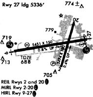
| APD | AIRPORT DIAGRAM | NE-3 | |
| HOT | HOT SPOT | NE-3 | |
| IAP | COPTER RNAV (GPS) RWY 09 | NE-3 | |
| IAP | COPTER RNAV (GPS) RWY 27 | NE-3 | |
| IAP | ILS OR LOC RWY 09 | NE-3 | |
| IAP | ILS OR LOC RWY 27 | NE-3 | |
| IAP | RNAV (GPS) RWY 09 | NE-3 | |
| IAP | RNAV (GPS) RWY 27 | NE-3 | |
| IAP | VOR RWY 09 | NE-3 | |
| MIN | ALTERNATE MINIMUMS | NE-3 | |
| MIN | TAKEOFF MINIMUMS | NE-3 | |
| STAR | TRSTN THREE (RNAV) | NE-3 |
Terminal Procedures are only available for airports in several countries with more being added all the time. If you are looking for a specific country's charts, please send an email to support(at)airportguide.com stating the country name. This will be used to prioritize the implementation.
Navigation Aids (Navaids) near HGR
| Dist (NM) | ID | Morse Code | Name | Type | Freq | True Hdg | Mag Hdg |
|---|---|---|---|---|---|---|---|
| 6.0 | HGR | . . . . _ _ . . _ . | Hagerstown | VOR | 109.80 | 263 | 273 |
| 17.0 | THS | _ . . . . . . . | St Thomas | VORTAC | 115.00 | 322 | 332 |
| 20.2 | MRB | _ _ . _ . _ . . . | Martinsburg | VORTAC | 112.10 | 196 | 206 |
| 24.1 | FDK | . . _ . _ . . _ . _ | Frederick | VOR | 109.00 | 137 | 148 |
| 36.9 | EMI | . _ _ . . | Westminster | VORTAC | 117.90 | 110 | 121 |
| 41.1 | EUD | . . . _ _ . . | York | NDB | 254 | 71 | 82 |
| 41.5 | GAI | _ _ . . _ . . | Gaithersburg | NDB | 385 | 141 | 152 |
| 43.5 | CX | _ . _ . _ . . _ | Latle | NDB | 219 | 49 | 60 |
| 45.5 | GDX | _ _ . _ . . _ . . _ | Goodwin Lake | NDB | 227 | 186 | 196 |
| 45.5 | AOO | . _ _ _ _ _ _ _ | Altoona | VOR | 108.80 | 324 | 334 |
| 46.7 | HAR | . . . . . _ . _ . | Harrisburg | VORTAC | 112.50 | 40 | 51 |
| 47.3 | CBE | _ . _ . _ . . . . | Cumberland | NDB | 317 | 265 | 275 |
| 48.0 | AML | . _ _ _ . _ . . | Armel | VOR-DME | 113.50 | 165 | 176 |
| 49.8 | MD | _ _ _ . . | Enola | NDB | 204 | 49 | 60 |
| 50.7 | FND | . . _ . _ . _ . . | Ellicott | NDB | 371 | 119 | 130 |
| 53.1 | MDT | _ _ _ . . _ | Harrisburg | VOT | 110.00 | 56 | 67 |
| 54.4 | GTN | _ _ . _ _ . | Georgetown | NDB | 323 | 148 | 159 |
| 55.9 | LDN | . _ . . _ . . _ . | Linden | VORTAC | 114.30 | 203 | 213 |
| 56.9 | IUB | . . . . _ _ . . . | Institute | NDB | 404 | 116 | 127 |
| 58.4 | BUH | _ . . . . . _ . . . . | Anne Arundel | NDB | 260 | 129 | 140 |
Nearby Airports with Fuel
Notices to Airmen (NOTAMS)
Remarks
| A110-10 | RWY 02 & 20 CLSD WHEN ATCT CLSD. |
| A110-11 | FOR CD WHEN ATCT IS CLSD CTC POTOMAC APCH AT 866-709-4993. |
| A110-12 | RWY 02/20 CLSD TO SKED ACR OPS WITH MORE THAN 9 PAX SEATS AND NON SKED ACR OPS WITH MORE THAN 30 PAX SEATS EXCP FOR TAXI. |
| A110-6 | BIRDS ON & INVOF ARPT. |
| A110-7 | LOW LEVEL MIL ACFT 10 NM NORTH ON VR708 OPERATING EAST TO WEST. |
| A110-8 | ULTRALIGHT ACT 12 NM EAST TO 5000 FT MSL. |
| A110-9 | TWY 'P' NOT AVBL FOR AIR CARRIER OPS. |
| A17 | AP UNATTND 2200-0500. |
| A26 | ARFF INDEX C AVBL UPON REQ; CTC AMGR. |
| A26 1 | PPR 24 HRS FOR UNSKED ACR OPNS WITH MORE THAN 30 PSGR SEATS CALL AMGR 240-313-2764. |
| A70-FUEL-10 | 0LL FUEL AVBL 0500-2200 CALL 301-791-9119. DOD CONTRACT FUEL AVBL. |
| A81-APT | WHEN ATCT CLSD ACTVT MALSR RWY 27; REIL RWY 09; HIRL RWY 09/27 - CTAF. |
Runways
Runway Summary
| Runways: | 02/20 09/27 |
| Longest Runway: | 09/27 is 7000 ft (2134 m) long |
| Runways with an Instrument Approach: | 09, 27 |
HGR Airport Runway Details
| Runway 02/20 | 3165 ft x 100 ft (965 m x 30 m) | |
| Runway Length Source: | NGS as of 08/10/2009 | |
| Surface: | Asphalt - Good condition - No special surface treatment | |
| Runway Pavement Class: | 26 /F/B/X/T | |
| Runway Edge Lights: | Medium Intensity | |
Runway Weight Bearing Capacity (in thousands of pounds) |
||
| Single Wheel Landing Gear: | 80.0 | |
| Dual Wheel Landing Gear: | 100.0 | |
| Dual Tandem Wheel Landing Gear: | 170.0 | |
Runway 02 |
Runway 20 |
|
Elevation: |
692.0 | 702.9 |
Latitude: |
39-42-15.0909N | 39-42-45.3221N |
Longitude: |
077-43-43.5868W | 077-43-33.2033W |
|
Runway True Alignment: |
015 | 195 |
Glide Path Angle: |
4.0 degrees | 4.0 degrees |
Traffic Pattern: |
Left | Left |
Runway Markings Type: |
Basic | Basic |
Runway Markings Condition: |
Good | Good |
Visual Glide Slope Indicators: |
2-Light PAPI On Left Side Of Runway | 2-Light PAPI On Left Side Of Runway |
REIL: |
Yes | Yes |
Threshold Crossing Height: |
53 | 33 |
Declared Distances |
||
Take Off Run Avbl. (TORA): |
3165 | 3165 |
Take Off Distance Avbl. (TODA): |
3165 | 3165 |
Actual Stop Dist. Avbl. (ASDA): |
3165 | 3165 |
Landing Dist. Avbl. (LDA): |
3165 | 3165 |
| Runway 09/27 | 7000 ft x 150 ft (2134 m x 46 m) | |
| Runway Length Source: | NGS as of 08/10/2009 | |
| Surface: | Asphalt - Good condition - Saw-cut or plastic grooved | |
| Runway Pavement Class: | 62 /F/B/X/T | |
| Runway Edge Lights: | High Intensity | |
Runway Weight Bearing Capacity (in thousands of pounds) |
||
| Single Wheel Landing Gear: | 100.0 | |
| Dual Wheel Landing Gear: | 150.0 | |
| Dual Tandem Wheel Landing Gear: | 250.0 | |
Runway 09 |
Runway 27 |
|
Elevation: |
664.4 | 685.5 |
Latitude: |
39-42-25.0637N | 39-42-36.4744N |
Longitude: |
077-44-18.1526W | 077-42-49.8178W |
|
Runway True Alignment: |
081 | 261 |
ILS Type: |
ILS/DME | ILS/DME |
Glide Path Angle: |
3.0 degrees | 3.0 degrees |
Traffic Pattern: |
Left | Left |
Runway Markings Type: |
Precision Instrument | Precision Instrument |
Runway Markings Condition: |
Good | Good |
Visual Glide Slope Indicators: |
4-Light PAPI On Left Side Of Runway | 4-Light PAPI On Left Side Of Runway |
Approach Light System: |
1,400 Foot Medium Intensity Approach Lighting System With Runway Alignment Indicator Lights | |
REIL: |
Yes | |
Threshold Crossing Height: |
55 | 55 |
Declared Distances |
||
Take Off Run Avbl. (TORA): |
7000 | 7000 |
Take Off Distance Avbl. (TODA): |
7000 | 7000 |
Actual Stop Dist. Avbl. (ASDA): |
7000 | 7000 |
Landing Dist. Avbl. (LDA): |
7000 | 7000 |
Services
Airframe Repair: |
Major |
Powerplant Repair: |
None |
Bottled Oxygen: |
None |
Bulk Oxygen: |
None |
Fuel Available: |
100LL |
Landing Fees: |
No |
Parking: |
Tiedowns available |
Maps & Diagrams
HGR Sectional
Flight Planning
at skyvector.com
at skyvector.com