Location
Latitude: |
39-55-01.2000N (39.917) |
Longitude: |
076-52-22.9000W (-76.873028) |
Elevation: |
494.7 feet MSL (151 m MSL) |
Magnetic Variation: |
11 W (as of April 2024 from WMM2020 model) |
Time Zone: |
UTC -5.0 (Standard Time) UTC -4.0 (Daylight Savings Time) |
From City: |
07 N.M. SW of York, Pennsylvania |
Found On: |
Washington Chart |
FAA Region: |
AEA |
Contacts
Manager: |
Privately owned: |
| MARK TOMLINSON 6054 LINCOLN HIGHWAY WEST THOMASVILLE, PA 17364 717-792-5566 |
YORK BLDG PRODUCTS INC PO BOX 2587 YORK, PA 17405 717-792-5566 |
Operations
Airport Status: |
Operational |
Facility Use: |
Public |
Type: |
Airport |
Activation Date: |
12/1940 |
Control tower: |
No |
Attendance (Months/Days/Hours): |
Months/Days/Hours ALL/MON-FRI/0600-1800 |
Boundary ARTCC: |
ZNY (New York) |
Responsible ARTCC: |
ZNY (New York) |
Lighting Schedule: |
SS-SR |
Segmented Circle Indicator: |
No |
Traffic Pattern Altitude (MSL): |
1495 feet (456 m) |
NOTAMs Facility: |
THV |
NOTAM-D Service: |
Yes |
International Airport of Entry: |
No |
Customs Landing Rights: |
No |
Military Landing Rights: |
Yes |
Civil/Military Joint Use: |
No |
Based Aircraft
| Single Engine: | 44 |
| Multi Engine: | 10 |
| Jet Engine: | 5 |
| GA Helicopters: | 3 |
Annual Operations (as of 12/05/2023)
| Total Operations: | 52750 | |
| Air Taxi: | 1050 | 2.0% |
| GA Local: | 31400 | 59.5% |
| GA Itinerant: | 20000 | 37.9% |
| Military Aircraft: | 300 | 0.6% |
Communications
| CTAF: | 123.000 |
| Unicom: | 123.000 |
| Clearance Del.: | 121.65 121.65 121.65 |
| Approach: | HARRISBURG |
| Departure: | HARRISBURG |
| ASOS: | 119.275 (717-792-5529) |
Fixed Based Operators (FBOs) & Fuel
(Click on a business for detail)
Please help us keep this information up to date. This is a FREE SERVICE just like everything else on Airport Guide! If you see that a business needs to be added, modified, or deleted please fill out our Update Form.
To add, modify, or delete a business click here.
Please help us keep this information up to date. This is a FREE SERVICE just like everything else on Airport Guide! If you see that a business needs to be added, modified, or deleted please fill out our Update Form.
Area Code: 717 |
| Business Name | Frequency | Phone | Fuel Grade |
|---|---|---|---|
| Airways, Inc.
Update FBO info |
792-0892 | ||
| York Aviation, Inc.
Update FBO info |
Unicom 122.8 | 792-5566 | 100LL, Jet A |
Flight Service Stations
| Primary | Alternate | |
| FSS on Field: | N | |
| FSS Name (ID): | Williamsport(IPT) | |
| Frequency: | ||
| Toll Free Phone: | 1-800-WX-BRIEF |
Instrument Procedures / Charts
FAA Terminal Procedures valid from 0901Z 03/21/24 to 0901Z 04/18/24.
There are various types of charts available for an airport. They are listed in the Page Type column. Here is a legend for those types:
APD - Airport Diagram
DP - Departure Procedure Charts
HOT - Hot Spots
IAP - Instrument Approach Procedure Charts
MIN - Minimums
STAR - Standard Terminal Arrival Charts
| Page Type | Page Name | Volume | Action Since Last Cycle |
|---|---|---|---|
| APD | AIRPORT DIAGRAM | NE-4 | |
| IAP | RNAV (GPS) RWY 17 | NE-4 | |
| IAP | RNAV (GPS) RWY 35 | NE-4 | |
| MIN | ALTERNATE MINIMUMS | NE-4 | |
| MIN | TAKEOFF MINIMUMS | NE-4 |
Terminal Procedures are only available for airports in several countries with more being added all the time. If you are looking for a specific country's charts, please send an email to support(at)airportguide.com stating the country name. This will be used to prioritize the implementation.
Navigation Aids (Navaids) near THV
| Dist (NM) | ID | Morse Code | Name | Type | Freq | True Hdg | Mag Hdg |
|---|---|---|---|---|---|---|---|
| 0.3 | EUD | . . . _ _ . . | York | NDB | 254 | 310 | 321 |
| 16.8 | CX | _ . _ . _ . . _ | Latle | NDB | 219 | 338 | 349 |
| 17.6 | MDT | _ _ _ . . _ | Harrisburg | VOT | 110.00 | 16 | 27 |
| 19.8 | MD | _ _ _ . . | Enola | NDB | 204 | 356 | 367 |
| 24.8 | HAR | . . . . . _ . _ . | Harrisburg | VORTAC | 112.50 | 338 | 349 |
| 25.8 | EMI | . _ _ . . | Westminster | VORTAC | 117.90 | 190 | 201 |
| 29.4 | LRP | . _ . . . _ . . _ _ . | Lancaster | VOR-DME | 117.30 | 65 | 76 |
| 34.4 | BZJ | _ . . . _ _ . . . _ _ _ | Bellgrove | NDB | 328 | 25 | 36 |
| 38.0 | FND | . . _ . _ . _ . . | Ellicott | NDB | 371 | 173 | 184 |
| 38.1 | FDK | . . _ . _ . . _ . _ | Frederick | VOR | 109.00 | 217 | 228 |
| 39.5 | IUB | . . . . _ _ . . . | Institute | NDB | 404 | 163 | 174 |
| 40.2 | RAV | . _ . . _ . . . _ | Ravine | VORTAC | 114.60 | 18 | 29 |
| 42.1 | APG | . _ . _ _ . _ _ . | Aberdeen | NDB | 349 | 122 | 133 |
| 42.2 | PPM | . _ _ . . _ _ . _ _ | Phillips | VOR-DME | 108.40 | 129 | 140 |
| 45.8 | BAL | _ . . . . _ . _ . . | Baltimore | VORTAC | 115.10 | 167 | 178 |
| 46.8 | GAI | _ _ . . _ . . | Gaithersburg | NDB | 385 | 196 | 207 |
| 47.2 | HGR | . . . . _ _ . . _ . | Hagerstown | VOR | 109.80 | 254 | 265 |
| 49.6 | THS | _ . . . . . . . | St Thomas | VORTAC | 115.00 | 271 | 282 |
| 50.2 | BUH | _ . . . . . _ . . . . | Anne Arundel | NDB | 260 | 173 | 184 |
| 52.4 | SEG | . . . . _ _ . | Selinsgrove | VOR-DME | 110.40 | 359 | 370 |
Nearby Airports with Fuel
Notices to Airmen (NOTAMS)
Remarks
| A110-1 | TREES WI PRIM SFC 83 FT IN FM THLD & 221 FT L OF RWY 17 CNTRLN; RAMP TIE-DOWN AREA, MEDIVAC PARKING PAD & TWY WI PRIM SFC ON R SIDE. |
| A110-2 | TWY TO RWY 35 CLSD TO ACFT WITH WINGSPAN OVER 60 FT. |
| A110-3 | RWY 17 TREES 1377 FT OUT 88 FT RIGHT APCH SLP 20:1 TO DTHR. |
| A110-4 | RWY 35 TREES 2695 FT OUT 426 FT RIGHT APCH SLP 23:1 TO DTHR. |
| A110-6 | FOR CD CTC HARRISBURG APCH AT 800-932-0712. |
| A57-17 | 20:1 TO DTHR. |
| A57-35 | RWY 35 APCH SLP 23:1 TO DTHR. |
| A58-17 | RWY 17 HAS +15 FT ROAD 10-200 FT FROM RWY END 250 FT LEFT & RIGHT; +15 BLAST FENCE 50-85 FT FROM RWY END MARKED AND LIGHTED. |
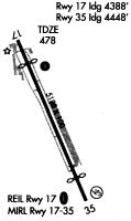
Runways
Runway Summary
| Runways: | 17/35 |
| Longest Runway: | 17/35 is 5188 ft (1581 m) long |
| Runways with an Instrument Approach: |
THV Airport Runway Details
| Runway 17/35 | 5188 ft x 100 ft (1581 m x 30 m) | |
| Surface: | Asphalt - Good condition - Saw-cut or plastic grooved | |
| Runway Edge Lights: | Medium Intensity | |
Runway Weight Bearing Capacity (in thousands of pounds) |
||
| Single Wheel Landing Gear: | 20.0 | |
| Dual Wheel Landing Gear: | 20.0 | |
| Dual Tandem Wheel Landing Gear: | 20.0 | |
Runway 17 |
Runway 35 |
|
Elevation: |
475.8 | 494.7 |
Latitude: |
39-55-24.4852N | 39-54-37.8889N |
Longitude: |
076-52-36.7772W | 076-52-09.0000W |
|
Runway True Alignment: |
155 | 335 |
Glide Path Angle: |
4.5 degrees | 3.7 degrees |
Traffic Pattern: |
Left | Left |
Runway Markings Type: |
Nonprecision Instrument | Nonprecision Instrument |
Runway Markings Condition: |
Good | Good |
Object at End: |
POLE | TREES |
Object Height: |
40 | 43 |
Object Marked/Lighted?: |
Lighted | Lighted |
Distance from End: |
226 | 404 |
Object Centerline Offset: |
183 ft. right of centerline | 223 ft. left of centerline |
Visual Glide Slope Indicators: |
4-Light PAPI On Left Side Of Runway | 4-Light PAPI On Left Side Of Runway |
REIL: |
Yes | Yes |
Threshold Crossing Height: |
20 | 28 |
Threshold Elevation: |
469.8 | 484.7 |
Displaced Threshold: |
794 | 739 |
Threshold Latitude: |
39-55-17.3574N | 39-54-44.5268N |
Threshold Longitude: |
076-52-32.5257W | 076-52-12.9639W |
Services
Airframe Repair: |
Major |
Powerplant Repair: |
Major |
Bottled Oxygen: |
High Pressure / Low Pressure |
Bulk Oxygen: |
High Pressure / Low Pressure |
Fuel Available: |
100LL, Jet A |
Landing Fees: |
No |
Parking: |
Hangars and tiedowns available |
Maps & Diagrams
THV Sectional
Flight Planning
at skyvector.com
at skyvector.com