Location
Latitude: |
39-36-29.8000N (39.608278) |
Longitude: |
077-00-27.6000W (-77.007667) |
Elevation: |
789.2 feet MSL (241 m MSL) |
Magnetic Variation: |
10.9 W (as of April 2024 from WMM2020 model) |
Time Zone: |
UTC -5.0 (Standard Time) UTC -4.0 (Daylight Savings Time) |
From City: |
03 N.M. N of Westminster, Maryland |
Found On: |
Washington Chart |
FAA Region: |
AEA |
Contacts
Manager: |
Publicly owned: |
| MARK L. MYERS 200 AIRPORT DRIVE, BOX 8 WESTMINSTER, MD 21157 410-876-9885 |
CARROLL COUNTY COMM 225 N CENTER ST. RM. 300 WESTMINSTER, MD 21157-5194 410-386-2044 |
Operations
Airport Status: |
Operational |
Facility Use: |
Public |
Type: |
Airport |
Activation Date: |
02/1943 |
Control tower: |
No |
Attendance (Months/Days/Hours): |
Months/Days/Hours ALL/ALL/0700-2000 |
Boundary ARTCC: |
ZNY (New York) |
Responsible ARTCC: |
ZDC (Washington) |
Lighting Schedule: |
SEE RMK |
Segmented Circle Indicator: |
Yes |
Traffic Pattern Altitude (MSL): |
1789 feet (545 m) |
NOTAMs Facility: |
DMW |
NOTAM-D Service: |
Yes |
International Airport of Entry: |
No |
Customs Landing Rights: |
No |
Military Landing Rights: |
Yes |
Civil/Military Joint Use: |
No |
Based Aircraft
| Single Engine: | 90 |
| Multi Engine: | 13 |
| Jet Engine: | 3 |
| GA Helicopters: | 6 |
Annual Operations (as of 05/04/2023)
| Total Operations: | 56224 | |
| Air Taxi: | 500 | 0.9% |
| GA Local: | 37090 | 66.0% |
| GA Itinerant: | 18544 | 33.0% |
| Military Aircraft: | 90 | 0.2% |
Communications
| CTAF: | 122.700 |
| Unicom: | 122.700 |
| Approach: | POTOMAC |
| Departure: | POTOMAC |
| AWOS-3: | 121.25 (410-876-1281) |
Fixed Based Operators (FBOs) & Fuel
(Click on a business for detail)
Please help us keep this information up to date. This is a FREE SERVICE just like everything else on Airport Guide! If you see that a business needs to be added, modified, or deleted please fill out our Update Form.
To add, modify, or delete a business click here.
Please help us keep this information up to date. This is a FREE SERVICE just like everything else on Airport Guide! If you see that a business needs to be added, modified, or deleted please fill out our Update Form.
Area Code: 410 |
| Business Name | Frequency | Phone | Fuel Grade |
|---|---|---|---|
| Gibson Aviation, Inc.
Update FBO info |
Unicom 122.85 | 800-344-2055 | |
| Westair, Incorporated
Update FBO info |
Unicom 122.7 | 876-7200 | 80, 100LL, Jet A |
Flight Service Stations
| Primary | Alternate | |
| FSS on Field: | N | |
| FSS Name (ID): | Leesburg(DCA) | |
| Frequency: | ||
| Toll Free Phone: | 1-800-WX-BRIEF |
Instrument Procedures / Charts
FAA Terminal Procedures valid from 0901Z 03/21/24 to 0901Z 04/18/24.
There are various types of charts available for an airport. They are listed in the Page Type column. Here is a legend for those types:
APD - Airport Diagram
DP - Departure Procedure Charts
HOT - Hot Spots
IAP - Instrument Approach Procedure Charts
MIN - Minimums
STAR - Standard Terminal Arrival Charts
| Page Type | Page Name | Volume | Action Since Last Cycle |
|---|---|---|---|
| DP | CONLE FOUR (RNAV) | NE-3 | |
| DP | TERPZ SEVEN (RNAV) | NE-3 | Changed |
| DP | TERPZ SEVEN (RNAV)[DELIMITER] CONT.1 | NE-3 | |
| IAP | RNAV (GPS) RWY 16 | NE-3 | |
| IAP | RNAV (GPS) RWY 34 | NE-3 | |
| IAP | VOR RWY 34 | NE-3 | |
| MIN | ALTERNATE MINIMUMS | NE-3 | |
| MIN | TAKEOFF MINIMUMS | NE-3 | |
| STAR | RAVNN SIX (RNAV) | NE-3 | |
| STAR | RAVNN SIX (RNAV)[DELIMITER] CONT.1 | NE-3 | |
| STAR | TRSTN THREE (RNAV) | NE-3 |
Terminal Procedures are only available for airports in several countries with more being added all the time. If you are looking for a specific country's charts, please send an email to support(at)airportguide.com stating the country name. This will be used to prioritize the implementation.
Navigation Aids (Navaids) near KDMW
| Dist (NM) | ID | Morse Code | Name | Type | Freq | True Hdg | Mag Hdg |
|---|---|---|---|---|---|---|---|
| 6.9 | EMI | . _ _ . . | Westminster | VORTAC | 117.90 | 168 | 179 |
| 19.6 | EUD | . . . _ _ . . | York | NDB | 254 | 17 | 28 |
| 20.7 | FDK | . . _ . _ . . _ . _ | Frederick | VOR | 109.00 | 235 | 246 |
| 22.0 | FND | . . _ . _ . _ . . | Ellicott | NDB | 371 | 150 | 161 |
| 26.2 | IUB | . . . . _ _ . . . | Institute | NDB | 404 | 137 | 148 |
| 27.3 | GAI | _ _ . . _ . . | Gaithersburg | NDB | 385 | 195 | 206 |
| 30.8 | BAL | _ . . . . _ . _ . . | Baltimore | VORTAC | 115.10 | 148 | 159 |
| 33.5 | BUH | _ . . . . . _ . . . . | Anne Arundel | NDB | 260 | 159 | 170 |
| 34.2 | CX | _ . _ . _ . . _ | Latle | NDB | 219 | 0 | 11 |
| 37.1 | MDT | _ _ _ . . _ | Harrisburg | VOT | 110.00 | 17 | 28 |
| 38.6 | MD | _ _ _ . . | Enola | NDB | 204 | 7 | 18 |
| 39.5 | HGR | . . . . _ _ . . _ . | Hagerstown | VOR | 109.80 | 278 | 289 |
| 39.6 | PPM | . _ _ . . _ _ . _ _ | Phillips | VOR-DME | 108.40 | 102 | 113 |
| 41.1 | GTN | _ _ . _ _ . | Georgetown | NDB | 323 | 187 | 198 |
| 41.2 | MRB | _ _ . _ . _ . . . | Martinsburg | VORTAC | 112.10 | 251 | 262 |
| 41.7 | HAR | . . . . . _ . _ . | Harrisburg | VORTAC | 112.50 | 356 | 367 |
| 41.9 | APG | . _ . _ _ . _ _ . | Aberdeen | NDB | 349 | 95 | 106 |
| 44.9 | DCA | _ . . _ . _ . . _ | Washington | VOR-DME | 111.00 | 181 | 192 |
| 45.1 | LRP | . _ . . . _ . . _ _ . | Lancaster | VOR-DME | 117.30 | 46 | 57 |
| 45.7 | AML | . _ _ _ . _ . . | Armel | VOR-DME | 113.50 | 207 | 218 |
Nearby Airports with Fuel
Notices to Airmen (NOTAMS)
Remarks
| A110*G | THIS AIRPORT HAS BEEN SURVEYED BY THE NATIONAL GEODETIC SURVEY. |
| A110-1 | ARPT UNATNDD CHRISTMAS. |
| A110-100 | GCO AVBL ON FREQ 121.725. IF UNA, FOR CD CTC POTOMAC APCH AT 866-429-5882. |
| A110-3 | WILDLIFE ON & INVOF ARPT. |
| A30-16/34 | DISTANCE MARKERS EVERY 1000 FT WEST SIDE OF RWY. |
| A43-16 | PAPI RWY 16 UNUSBL BYD 5 DEGS R OF CNTRLN. |
| A70-FUEL-10 | 0LL SELF SERVE 100LL AVAILABLE WITH CREDIT CARD. |
| A81-APT | ACTVT REIL RWYS 16 & 34; MIRL RWY 16/34; TWY LGTS - CTAF. |
| E147 | TPA FIXED WING 810 FT, TURBO PROP & JET 1310 FT. |
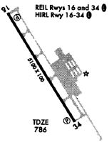
Runways
Runway Summary
| Runways: | 16/34 |
| Longest Runway: | 16/34 is 5100 ft (1554 m) long |
| Runways with an Instrument Approach: |
KDMW Heliport Runway Details
| Runway 16/34 | 5100 ft x 100 ft (1554 m x 30 m) | |
| Surface: | Asphalt - Fair condition - Saw-cut or plastic grooved | |
| Runway Edge Lights: | Medium Intensity | |
Runway Weight Bearing Capacity (in thousands of pounds) |
||
| Single Wheel Landing Gear: | 22.0 | |
| Dual Wheel Landing Gear: | 50.0 | |
Runway 16 |
Runway 34 |
|
Elevation: |
789.2 | 774.3 |
Latitude: |
39-36-51.1753N | 39-36-08.4192N |
Longitude: |
077-00-44.8215W | 077-00-10.3137W |
|
Runway True Alignment: |
148 | 328 |
Glide Path Angle: |
3.0 degrees | 3.0 degrees |
Traffic Pattern: |
Right | |
Runway Markings Type: |
Nonprecision Instrument | Nonprecision Instrument |
Runway Markings Condition: |
Good | Good |
Visual Glide Slope Indicators: |
4-Light PAPI On Left Side Of Runway | 4-Light PAPI On Left Side Of Runway |
REIL: |
Yes | Yes |
Threshold Crossing Height: |
45 | 40 |
Services
Airframe Repair: |
None |
Powerplant Repair: |
None |
Fuel Available: |
Jet A |
Landing Fees: |
No |
Other Services: |
Hangar space, 2 spots left $1500.00 per month. |
Maps & Diagrams
KDMW Sectional
Flight Planning
at skyvector.com
at skyvector.com