Location
Latitude: |
39-04-40.7000N (39.077972) |
Longitude: |
077-33-27.0000W (-77.5575) |
Elevation: |
389.5 feet MSL (119 m MSL) |
Magnetic Variation: |
10.5 W (as of April 2024 from WMM2020 model) |
Time Zone: |
UTC -5.0 (Standard Time) UTC -4.0 (Daylight Savings Time) |
From City: |
03 N.M. S of Leesburg, Virginia |
Found On: |
Washington Chart |
FAA Region: |
AEA |
Contacts
Manager: |
Publicly owned: |
| SCOTT COFFMAN 1001 SYCOLIN ROAD, SE, SUITE 7 LEESBURG, VA 20175 703-737-7125 |
TOWN OF LEESBURG 25 WEST MARKET ST., 25 WEST MARKET ST. LEESBURG, VA 20176 703-777-2420 |
Operations
Airport Status: |
Operational |
Facility Use: |
Public |
Type: |
Airport |
Activation Date: |
10/1964 |
Control tower: |
Yes |
Attendance (Months/Days/Hours): |
Months/Days/Hours ALL/ALL/0600-2100 |
Boundary ARTCC: |
ZDC (Washington) |
Responsible ARTCC: |
ZDC (Washington) |
Lighting Schedule: |
SEE RMK |
Segmented Circle Indicator: |
Yes |
Traffic Pattern Altitude (MSL): |
1390 feet (424 m) |
NOTAMs Facility: |
JYO |
NOTAM-D Service: |
Yes |
International Airport of Entry: |
No |
Customs Landing Rights: |
Yes |
Military Landing Rights: |
Yes |
Civil/Military Joint Use: |
No |
Based Aircraft
| Single Engine: | 200 |
| Multi Engine: | 23 |
| Jet Engine: | 21 |
| GA Helicopters: | 4 |
| Gliders: | 1 |
Annual Operations (as of 12/31/2022)
| Total Operations: | 81873 | |
| Commercial: | 124 | 0.2% |
| Air Taxi: | 627 | 0.8% |
| GA Local: | 42160 | 51.5% |
| GA Itinerant: | 38884 | 47.5% |
| Military Aircraft: | 78 | 0.1% |
Communications
| CTAF: | 127.500 |
| Unicom: | 122.975 |
| Tower: | LEESBURG TOWER 127.5 Hrs: 1300-2300Z++ |
| Clearance Del.: | 120.5 |
| Ground: | 120.5 |
| Approach: | POTOMAC |
| Departure: | POTOMAC |
| AWOS-3: | 125.225 (703-777-3781) |
- TWR OPNS CURRENTLY SUPPORTED BY MOBILE/REMOTE ATCT SYS.
Fixed Based Operators (FBOs) & Fuel
(Click on a business for detail)
Please help us keep this information up to date. This is a FREE SERVICE just like everything else on Airport Guide! If you see that a business needs to be added, modified, or deleted please fill out our Update Form.
To add, modify, or delete a business click here.
Please help us keep this information up to date. This is a FREE SERVICE just like everything else on Airport Guide! If you see that a business needs to be added, modified, or deleted please fill out our Update Form.
Area Code: 703 |
| Business Name | Frequency | Phone | Fuel Grade |
|---|---|---|---|
| American Beechcraft Company
Update FBO info |
800-336-0219, 703-478-8001 | 100LL, Jet A | |
| American Flight Academy
Update FBO info |
800-253-0494, 703-771-1950 | ||
| AV-ED Flight School, Inc.
Update FBO info |
703-478-1036, 703-777-9252 | ||
| Aviation Methods, Inc.
Update FBO info |
800-235-9724 | ||
| Blue Sky Aviation, Inc.
Update FBO info |
703-759-7107, 703-779-2891 | ||
| Leesburg Pilots Association
Website Update FBO info |
703-450-7569 |
Flight Service Stations
| Primary | Alternate | |
| FSS on Field: | N | |
| FSS Name (ID): | Leesburg(DCA) | |
| Frequency: | ||
| Toll Free Phone: | 1-800-WX-BRIEF |
Instrument Procedures / Charts
FAA Terminal Procedures valid from 0901Z 03/21/24 to 0901Z 04/18/24.
There are various types of charts available for an airport. They are listed in the Page Type column. Here is a legend for those types:
APD - Airport Diagram
DP - Departure Procedure Charts
HOT - Hot Spots
IAP - Instrument Approach Procedure Charts
MIN - Minimums
STAR - Standard Terminal Arrival Charts
| Page Type | Page Name | Volume | Action Since Last Cycle |
|---|---|---|---|
| APD | AIRPORT DIAGRAM | NE-3 | |
| DP | CLTCH THREE (RNAV) | NE-3 | |
| DP | JDUBB FOUR (RNAV) | NE-3 | |
| DP | PTOMC TWO (RNAV) | NE-3 | |
| DP | SCRAM SIX (RNAV) | NE-3 | |
| IAP | ILS OR LOC RWY 17 | NE-3 | |
| IAP | RNAV (GPS) RWY 17 | NE-3 | |
| MIN | ALTERNATE MINIMUMS | NE-3 | |
| MIN | TAKEOFF MINIMUMS | NE-3 | |
| STAR | DOCCS THREE | NE-3 | |
| STAR | DOCCS THREE[DELIMITER] CONT.1 | NE-3 | |
| STAR | GIBBZ FIVE (RNAV) | NE-3 | Changed |
| STAR | GIBBZ FIVE (RNAV)[DELIMITER] CONT.1 | NE-3 | Changed |
| STAR | HYPER NINE (RNAV) | NE-3 | Changed |
| STAR | HYPER NINE (RNAV)[DELIMITER] CONT.1 | NE-3 | Changed |
| STAR | HYPER NINE (RNAV)[DELIMITER] CONT.2 | NE-3 | Changed |
| STAR | PRIVO THREE | NE-3 | |
| STAR | PRIVO THREE[DELIMITER] CONT.1 | NE-3 | |
| STAR | TRSTN THREE (RNAV) | NE-3 |
Terminal Procedures are only available for airports in several countries with more being added all the time. If you are looking for a specific country's charts, please send an email to support(at)airportguide.com stating the country name. This will be used to prioritize the implementation.
Navigation Aids (Navaids) near KJYO
| Dist (NM) | ID | Morse Code | Name | Type | Freq | True Hdg | Mag Hdg |
|---|---|---|---|---|---|---|---|
| 9.6 | AML | . _ _ _ . _ . . | Armel | VOR-DME | 113.50 | 153 | 164 |
| 14.8 | GDX | _ _ . _ . . _ . . _ | Goodwin Lake | NDB | 227 | 239 | 249 |
| 19.0 | GAI | _ _ . . _ . . | Gaithersburg | NDB | 385 | 73 | 84 |
| 21.8 | FDK | . . _ . _ . . _ . _ | Frederick | VOR | 109.00 | 22 | 33 |
| 22.1 | GTN | _ _ . _ _ . | Georgetown | NDB | 323 | 113 | 124 |
| 22.9 | MRB | _ _ . _ . _ . . . | Martinsburg | VORTAC | 112.10 | 323 | 333 |
| 27.6 | DCA | _ . . _ . _ . . _ | Washington | VOR-DME | 111.00 | 118 | 129 |
| 29.9 | CSN | _ . _ . . . . _ . | Casanova | VORTAC | 116.30 | 208 | 218 |
| 31.0 | DCA | _ . . _ . _ . . _ | Oxonn | NDB | 332 | 126 | 137 |
| 32.6 | DAA | _ . . . _ . _ | Davee | NDB | 223 | 139 | 150 |
| 33.1 | LDN | . _ . . _ . . _ . | Linden | VORTAC | 114.30 | 246 | 256 |
| 35.7 | ADW | . _ _ . . . _ _ | Andrews Afb | VOT | 109.60 | 117 | 128 |
| 36.1 | ADW | . _ _ . . . _ _ | Andrews | VORTAC | 113.10 | 116 | 127 |
| 36.7 | EMI | . _ _ . . | Westminster | VORTAC | 117.90 | 46 | 57 |
| 37.1 | BUH | _ . . . . . _ . . . . | Anne Arundel | NDB | 260 | 89 | 100 |
| 38.4 | FND | . . _ . _ . _ . . | Ellicott | NDB | 371 | 70 | 81 |
| 39.7 | HGR | . . . . _ _ . . _ . | Hagerstown | VOR | 109.80 | 339 | 349 |
| 40.8 | MSQ | _ _ . . . _ _ . _ | Nailr | NDB | 351 | 203 | 213 |
| 42.1 | BAL | _ . . . . _ . _ . . | Baltimore | VORTAC | 115.10 | 82 | 93 |
| 44.0 | OTT | _ _ _ _ _ | Nottingham | VORTAC | 113.70 | 120 | 131 |
Nearby Airports with Fuel
Notices to Airmen (NOTAMS)
Remarks
| A110-10 | RAMP FENCE S/W SIDE RAMPS LEAD IN LINES ON WEST RAMP NA. |
| A110-12 | PSBL THERMAL PLUMES FM PWR PLANT 1.3 NM SSE. |
| A110-13 | FOR CD WHEN ATCT CLSD, CTC POTOMAC APCH 118.55 OR 866-709-4993. |
| A110-3 | BIRDS & DEER ON & INVOF ARPT. |
| A110-7 | HEL ACT ON & INVOF ARPT. |
| A110-9 | CALM WIND USE RWY 17. |
| A49-17 | NSTD ODALS, 3 LGT CONFIGURATION. |
| A81-APT | WHEN ATCT CLSD ACTVT ODALS RWY 17; REIL RWY 17 & 35; PAPI RWY 17 & 35; HIRL RWY 17/35 - CTAF. |
| E80 | US CUST AVBL MON-SUN 0600-2100. CALL COMMAND CNTR 703-661-2800 FOR APNTMT. 24 HR NOTICE RQRD. |
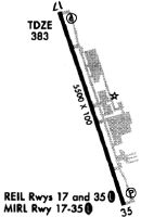
Runways
Runway Summary
| Runways: | 17/35 |
| Longest Runway: | 17/35 is 5500 ft (1676 m) long |
| Runways with an Instrument Approach: | 17 |
KJYO Airport Runway Details
| Runway 17/35 | 5500 ft x 100 ft (1676 m x 30 m) | |
| Runway Length Source: | 3RD PARTY SURVEY as of 12/18/2015 | |
| Surface: | Asphalt - Good condition - Saw-cut or plastic grooved | |
| Runway Pavement Class: | 63 /F/A/W/U | |
| Runway Edge Lights: | High Intensity | |
Runway Weight Bearing Capacity (in thousands of pounds) |
||
| Single Wheel Landing Gear: | 30.0 | |
| Dual Wheel Landing Gear: | 70.0 | |
Runway 17 |
Runway 35 |
|
Elevation: |
377.6 | 387.2 |
Latitude: |
39-05-06.4264N | 39-04-14.9401N |
Longitude: |
077-33-38.1846W | 077-33-15.8029W |
|
Runway True Alignment: |
161 | 341 |
ILS Type: |
ILS/DME | |
Glide Path Angle: |
3.0 degrees | 3.0 degrees |
Traffic Pattern: |
Left | Left |
Runway Markings Type: |
Precision Instrument | Nonprecision Instrument |
Runway Markings Condition: |
Good | Good |
Object at End: |
TREE | TREE |
Object Height: |
25 | 45 |
Distance from End: |
812 | 2027 |
Object Centerline Offset: |
374 ft. left of centerline | 75 ft. left of centerline |
Visual Glide Slope Indicators: |
4-Light PAPI On Left Side Of Runway | 4-Light PAPI On Left Side Of Runway |
Approach Light System: |
Omnidirectional Approach Lighting System | |
REIL: |
Yes | Yes |
Touchdown Lights: |
No | |
Centerline Lights: |
No | |
Threshold Crossing Height: |
45 | 37 |
Services
Airframe Repair: |
Major |
Powerplant Repair: |
Major |
Fuel Available: |
100LL |
Landing Fees: |
No |
Parking: |
Tiedowns available |
Maps & Diagrams
KJYO Sectional
Flight Planning
at skyvector.com
at skyvector.com