Location
Latitude: |
42-25-39.4324N (42.42762) |
Longitude: |
073-17-27.0233W (-73.29084) |
Elevation: |
1188.4 feet MSL (362 m MSL) |
Magnetic Variation: |
13.2 W (as of April 2024 from WMM2020 model) |
Time Zone: |
UTC -5.0 (Standard Time) UTC -4.0 (Daylight Savings Time) |
From City: |
02 N.M. W of Pittsfield, Massachusetts |
Found On: |
New York Chart |
FAA Region: |
ANE |
Contacts
Manager: |
Publicly owned: |
| DANIEL SHEARER PITTSFIELD MUNICIPAL AIRPORT, 832 TAMARACK RD PITTSFIELD, MA 01201 413-448-9790 |
CITY OF PITTSFIELD 70 ALLEN ST PITTSFIELD, MA 01201 413-448-9790 |
Operations
Airport Status: |
Operational |
Facility Use: |
Public |
Type: |
Airport |
Activation Date: |
05/1941 |
Control tower: |
No |
Attendance (Months/Days/Hours): |
Months/Days/Hours ALL/ALL/0700-1500 |
Boundary ARTCC: |
ZBW (Boston) |
Responsible ARTCC: |
ZBW (Boston) |
Lighting Schedule: |
SEE RMK |
Segmented Circle Indicator: |
Yes |
Traffic Pattern Altitude (MSL): |
2188 feet (667 m) |
NOTAMs Facility: |
PSF |
NOTAM-D Service: |
Yes |
International Airport of Entry: |
No |
Customs Landing Rights: |
Yes |
Military Landing Rights: |
Yes |
Civil/Military Joint Use: |
No |
Based Aircraft
| Single Engine: | 12 |
| Multi Engine: | 4 |
| Jet Engine: | 8 |
| GA Helicopters: | 1 |
Annual Operations (as of 08/28/2018)
| Total Operations: | 46593 | |
| Air Taxi: | 5159 | 11.1% |
| GA Local: | 27886 | 59.9% |
| GA Itinerant: | 12548 | 26.9% |
| Military Aircraft: | 1000 | 2.1% |
Communications
| CTAF: | 122.700 |
| Unicom: | 122.700 |
| Clearance Del.: | 128.6 128.6 128.6 |
| Approach: | ALBANY |
| Departure: | ALBANY |
| ASOS: | 135.375 (413-499-3273) |
Fixed Based Operators (FBOs) & Fuel
(Click on a business for detail)
Please help us keep this information up to date. This is a FREE SERVICE just like everything else on Airport Guide! If you see that a business needs to be added, modified, or deleted please fill out our Update Form.
To add, modify, or delete a business click here.
Please help us keep this information up to date. This is a FREE SERVICE just like everything else on Airport Guide! If you see that a business needs to be added, modified, or deleted please fill out our Update Form.
Area Code: 413 |
| Business Name | Frequency | Phone | Fuel Grade |
|---|---|---|---|
| Lyon Aviation
Update FBO info |
Unicom 122.7 | 443-6700 | 100LL, Jet A |
| Pittsfield Aviation Enterprise
Update FBO info |
Unicom 122.775 | 499-3548 | 100LL |
Flight Service Stations
| Primary | Alternate | |
| FSS on Field: | N | |
| FSS Name (ID): | Burlington(BTV) | |
| Frequency: | ||
| Toll Free Phone: | 1-800-WX-BRIEF |
Instrument Procedures / Charts
FAA Terminal Procedures valid from 0901Z 03/21/24 to 0901Z 04/18/24.
There are various types of charts available for an airport. They are listed in the Page Type column. Here is a legend for those types:
APD - Airport Diagram
DP - Departure Procedure Charts
HOT - Hot Spots
IAP - Instrument Approach Procedure Charts
MIN - Minimums
STAR - Standard Terminal Arrival Charts
| Page Type | Page Name | Volume | Action Since Last Cycle |
|---|---|---|---|
| IAP | LOC RWY 26 | NE-1 | |
| IAP | RNAV (GPS) RWY 08 | NE-1 | |
| IAP | RNAV (GPS) RWY 26 | NE-1 | |
| MIN | ALTERNATE MINIMUMS | NE-1 | |
| MIN | TAKEOFF MINIMUMS | NE-1 |
Terminal Procedures are only available for airports in several countries with more being added all the time. If you are looking for a specific country's charts, please send an email to support(at)airportguide.com stating the country name. This will be used to prioritize the implementation.
Navigation Aids (Navaids) near PSF
| Dist (NM) | ID | Morse Code | Name | Type | Freq | True Hdg | Mag Hdg |
|---|---|---|---|---|---|---|---|
| 15.5 | GBR | _ _ . _ . . . . _ . | Great Barrington | NDB | 395 | 198 | 211 |
| 17.2 | CTR | _ . _ . _ . _ . | Chester | VOR-DME | 115.10 | 118 | 131 |
| 21.9 | PFH | . _ _ . . . _ . . . . . | Philmont | NDB | 272 | 241 | 254 |
| 29.7 | ALB | . _ . _ . . _ . . . | Albany | VORTAC | 115.30 | 310 | 323 |
| 30.1 | BAF | _ . . . . _ . . _ . | Barnes | VORTAC | 113.00 | 121 | 134 |
| 30.1 | ALB | . _ . _ . . _ . . . | Albany | VOT | 108.20 | 308 | 321 |
| 34.1 | CAM | _ . _ . . _ _ _ | Cambridge | VOR-DME | 115.00 | 356 | 369 |
| 35.4 | VWD | . . . _ . _ _ _ . . | Mount Snow | NDB | 224 | 31 | 44 |
| 36.6 | CEF | _ . _ . . . . _ . | Westover | TACAN | 114.00 | 111 | 124 |
| 38.2 | HEU | . . . . . . . _ | Hunter | NDB | 356 | 312 | 325 |
| 39.6 | BDL | _ . . . _ . . . _ . . | Bradley | VORTAC | 109.00 | 137 | 150 |
| 40.0 | BDL | _ . . . _ . . . _ . . | Bradley | VOT | 111.40 | 137 | 150 |
| 41.8 | PWL | . _ _ . . _ _ . _ . . | Pawling | VOR-DME | 114.30 | 199 | 212 |
| 45.2 | ORE | _ _ _ . _ . . | Orange | NDB | 205 | 78 | 91 |
| 49.3 | EEN | . . _ . | Keene | DME | 109.4 | 63 | 76 |
| 50.4 | HFD | . . . . . . _ . _ . . | Hartford | VOT | 108.20 | 145 | 158 |
| 51.5 | IGN | . . _ _ . _ . | Kingston | VOR-DME | 117.60 | 207 | 220 |
| 51.5 | GF | _ _ . . . _ . | Ganse | NDB | 209 | 344 | 357 |
| 55.0 | GDM | _ _ . _ . . _ _ | Gardner | VOR-DME | 110.60 | 82 | 96 |
| 56.6 | GFL | _ _ . . . _ . . _ . . | Glens Falls | VORTAC | 110.20 | 345 | 358 |
Nearby Airports with Fuel
Notices to Airmen (NOTAMS)
Remarks
| A110-1 | OBSTN LGTD POLES 0.9 NM SE AT 1960 FT; 1.1 NM SE AT 1470 FT; 1.7 NM SW AT 2171 FT (OTS INDEFLY); 1.3 NM NE AT 1330 FT; 2.3 NM NW AT 1890 FT (OTS INDEFLY). |
| A110-12 | FOR CD CTC ALBANY APCH AT 518-862-2299. |
| A110-13 | FBO ATNDD MON-FRI 0800-1800, SAT-SUN 0800-1700. FOR FUEL AFT HRS CALL 413-443-6700. |
| A110-14 | RWY 14-32 CK NOTAMS FOR CHGS TO LEN & WID. |
| A110-4 | BIRDS & WILDLIFE ON & INVOF ARPT. |
| A110-6 | ALL ACFT USE TWY A, C & D FOR RWY 08-26. TWY A USE LTD TO ACFT WITH WINGSPAN LESS THAN 79 FT. AFT BACK TAX RWY 26 USE TWY D TO TURN ARND. |
| A110-7 | CK NOTAMS FOR ARPT COND. AIRFIELD SFC COND NOT MNT & SNOW REMOVAL NOT GUARANTEED BTN 1500-0700. |
| A110-8 | NOISE ABATEMENT PROCS IN EFCT 2300-0700. |
| A24 | REFER TO RATES AND CHARGES HTTPS://WWW.CITYOFPITTSFIELD.ORG/DEPARTMENTS/AIRPORT/AIRPORT_INFORMATION/FEES.PHP |
| A81-APT | ACTVT REIL RWY 26; PAPI RWY 26; MIRL RWY 08/26 & 14/32 - CTAF. |
| E111 | BUILT PRIOR TO 1959. |
| E80 | LDG & PRKG FEES. |
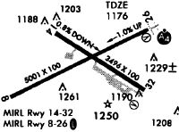
Runways
Runway Summary
| Runways: | 08/26 14/32 |
| Longest Runway: | 08/26 is 5791 ft (1765 m) long |
| Runways with an Instrument Approach: | 26 |
PSF Airport Runway Details
| Runway 08/26 | 5791 ft x 100 ft (1765 m x 30 m) | |
| Runway Length Source: | 3RD PARTY SURVEY as of 05/24/2012 | |
| Surface: | Asphalt - Good condition - Saw-cut or plastic grooved | |
| Runway Pavement Class: | 43 /F/D/X/T | |
| Runway Edge Lights: | Medium Intensity | |
Runway Weight Bearing Capacity (in thousands of pounds) |
||
| Single Wheel Landing Gear: | 44.0 | |
| Dual Wheel Landing Gear: | 54.0 | |
Runway 08 |
Runway 26 |
|
Elevation: |
1188.4 | 1132.1 |
Latitude: |
42-25-28.4465N | 42-25-53.2822N |
Longitude: |
073-18-00.8516W | 073-16-51.3048W |
|
Runway True Alignment: |
064 | 244 |
ILS Type: |
LOC/DME | |
Glide Path Angle: |
0.0 degrees | 3.0 degrees |
Traffic Pattern: |
Left | Right |
Runway Markings Type: |
Precision Instrument | Precision Instrument |
Runway Markings Condition: |
Good | Good |
Object at End: |
TREES | |
Object Height: |
35 | |
Object Marked/Lighted?: |
Lighted | |
Distance from End: |
750 | |
Object Centerline Offset: |
350 ft. left of centerline | |
Visual Glide Slope Indicators: |
4-Light PAPI On Left Side Of Runway | |
REIL: |
No | Yes |
Threshold Crossing Height: |
50 |
| Runway 14/32 | 3496 ft x 100 ft (1066 m x 30 m) | |
| Runway Length Source: | 3RD PARTY SURVEY as of 05/24/2012 | |
| Surface: | Asphalt - Good condition - No special surface treatment | |
| Runway Pavement Class: | 7 /F/D/X/T | |
| Runway Edge Lights: | Medium Intensity | |
Runway Weight Bearing Capacity (in thousands of pounds) |
||
| Single Wheel Landing Gear: | 25.0 | |
Runway 14 |
Runway 32 |
|
Elevation: |
1170.3 | 1141.8 |
Latitude: |
42-25-46.4113N | 42-25-27.7098N |
Longitude: |
073-17-48.1778W | 073-17-09.0000W |
|
Runway True Alignment: |
123 | 303 |
Glide Path Angle: |
0.0 degrees | 0.0 degrees |
Traffic Pattern: |
Left | Right |
Runway Markings Type: |
Basic | Basic |
Runway Markings Condition: |
Good | Good |
Object at End: |
TREES | TREES |
Object Height: |
50 | 20 |
Distance from End: |
1000 | 600 |
Object Centerline Offset: |
350 ft. left of centerline | |
REIL: |
No | No |
Services
Airframe Repair: |
Major |
Powerplant Repair: |
Major |
Fuel Available: |
100LL |
Landing Fees: |
No |
Parking: |
Tiedowns available |
Maps & Diagrams
PSF Sectional
Flight Planning
at skyvector.com
at skyvector.com