Location
Latitude: |
39-41-58.8000N (39.699667) |
Longitude: |
087-40-14.8000W (-87.670778) |
Elevation: |
654.2 feet MSL (199 m MSL) |
Magnetic Variation: |
3.9 W (as of April 2024 from WMM2020 model) |
Time Zone: |
UTC -6.0 (Standard Time) UTC -5.0 (Daylight Savings Time) |
From City: |
05 N.M. N of Paris, Illinois |
Found On: |
St Louis Chart |
FAA Region: |
AGL |
Contacts
Manager: |
Publicly owned: |
| TOM TUTTLE 15551 ARPT RD PARIS, IL 61944-1944 217-465-8474 |
SUP BOARD OF EDGAR CO 15551 ARPT RD PARIS, IL 61944-1944 (217) 466-7433 |
Operations
Airport Status: |
Operational |
Facility Use: |
Public |
Type: |
Airport |
Activation Date: |
04/1975 |
Control tower: |
No |
Attendance (Months/Days/Hours): |
Months/Days/Hours ALL/MON-FRI/0800-1600 |
Boundary ARTCC: |
ZID (Indianapolis) |
Responsible ARTCC: |
ZID (Indianapolis) |
Lighting Schedule: |
SEE RMK |
Segmented Circle Indicator: |
Yes |
Traffic Pattern Altitude (MSL): |
1654 feet (504 m) |
NOTAMs Facility: |
PRG |
NOTAM-D Service: |
Yes |
International Airport of Entry: |
No |
Customs Landing Rights: |
No |
Military Landing Rights: |
Yes |
Civil/Military Joint Use: |
No |
Based Aircraft
| Single Engine: | 13 |
| Multi Engine: | 1 |
| Gliders: | 1 |
Annual Operations (as of 08/31/2022)
| Total Operations: | 6900 | |
| Air Taxi: | 50 | 0.7% |
| GA Local: | 3350 | 48.6% |
| GA Itinerant: | 3500 | 50.7% |
Communications
| CTAF: | 123.000 |
| Unicom: | 123.000 |
| Approach: | HULMAN 125.45 125.45 125.45 |
| Departure: | HULMAN 125.45 125.45 125.45 |
| AWOS-3: | 124.175 (217-465-4304) |
Fixed Based Operators (FBOs) & Fuel
(Click on a business for detail)
Please help us keep this information up to date. This is a FREE SERVICE just like everything else on Airport Guide! If you see that a business needs to be added, modified, or deleted please fill out our Update Form.
To add, modify, or delete a business click here.
Please help us keep this information up to date. This is a FREE SERVICE just like everything else on Airport Guide! If you see that a business needs to be added, modified, or deleted please fill out our Update Form.
Area Code: 217 |
| Business Name | Frequency | Phone | Fuel Grade |
|---|---|---|---|
| Edgar County Airport
Update FBO info |
Unicom 123.0 | 465-8474 | 100LL |
Flight Service Stations
| Primary | Alternate | |
| FSS on Field: | N | |
| FSS Name (ID): | Saint Louis(STL) | |
| Frequency: | ||
| Toll Free Phone: | 1-800-WX-BRIEF |
Instrument Procedures / Charts
FAA Terminal Procedures valid from 0901Z 03/21/24 to 0901Z 04/18/24.
There are various types of charts available for an airport. They are listed in the Page Type column. Here is a legend for those types:
APD - Airport Diagram
DP - Departure Procedure Charts
HOT - Hot Spots
IAP - Instrument Approach Procedure Charts
MIN - Minimums
STAR - Standard Terminal Arrival Charts
| Page Type | Page Name | Volume | Action Since Last Cycle |
|---|---|---|---|
| IAP | RNAV (GPS) RWY 09 | EC-3 | |
| IAP | RNAV (GPS) RWY 18 | EC-3 | |
| IAP | RNAV (GPS) RWY 27 | EC-3 | |
| IAP | RNAV (GPS) RWY 36 | EC-3 | |
| MIN | ALTERNATE MINIMUMS | EC-3 | |
| MIN | TAKEOFF MINIMUMS | EC-3 |
Terminal Procedures are only available for airports in several countries with more being added all the time. If you are looking for a specific country's charts, please send an email to support(at)airportguide.com stating the country name. This will be used to prioritize the implementation.
Navigation Aids (Navaids) near KPRG
| Dist (NM) | ID | Morse Code | Name | Type | Freq | True Hdg | Mag Hdg |
|---|---|---|---|---|---|---|---|
| 22.6 | HU | . . . . . . _ | Yinno | NDB | 245 | 145 | 149 |
| 23.2 | TTH | _ _ . . . . | Terre Haute | VORTAC | 115.30 | 122 | 126 |
| 23.5 | HMJ | . . . . _ _ . _ _ _ | Homer | NDB | 281 | 326 | 330 |
| 27.9 | MT | _ _ _ | Zebre | NDB | 347 | 236 | 240 |
| 28.2 | CZB | _ . _ . _ _ . . _ . . . | Casey | NDB | 359 | 213 | 217 |
| 28.5 | CM | _ . _ . _ _ | Veals | NDB | 407 | 304 | 308 |
| 31.4 | MTO | _ _ _ _ _ _ | Mattoon | DME | 109.4 | 245 | 249 |
| 34.4 | CMI | _ . _ . _ _ . . | Champaign | VORTAC | 110.00 | 305 | 309 |
| 36.0 | DN | _ . . _ . | Julip | NDB | 332 | 10 | 14 |
| 36.0 | DNV | _ . . _ . . . . _ | Danville | VORTAC | 111.00 | 8 | 12 |
| 36.7 | SIV | . . . . . . . . _ | Sullivan | NDB | 326 | 163 | 167 |
| 38.7 | CFJ | _ . _ . . . _ . . _ _ _ | Crawfordsville | NDB | 388 | 63 | 67 |
| 39.9 | TVX | _ . . . _ _ . . _ | Greencastle | NDB | 521 | 88 | 92 |
| 40.9 | RSV | . _ . . . . . . . _ | Robinson | VOR-DME | 108.40 | 178 | 182 |
| 41.2 | PLX | . _ _ . . _ . . _ . . _ | Palestine | NDB | 391 | 178 | 182 |
| 51.5 | DEC | _ . . . _ . _ . | Akley | FAN MARKER | 282 | 286 | |
| 52.0 | LA | . _ . . . _ | Earle | NDB | 401 | 32 | 36 |
| 54.8 | AXC | . _ _ . . _ _ . _ . | Adders | VORTAC | 117.20 | 272 | 275 |
| 55.9 | LWV | . _ . . . _ _ . . . _ | Lawrenceville | DME | 108.8 | 176 | 180 |
| 57.0 | SYZ | . . . _ . _ _ _ _ . . | Shelbyville | NDB | 365 | 252 | 255 |
Nearby Airports with Fuel
Notices to Airmen (NOTAMS)
Remarks
| A110-1 | FOR CD CTC HULMAN APCH AT 812-877-7581. |
| A42-09 | RWY 09 MARKINGS FADED. |
| A42-27 | RWY 27 MARKINGS FADED. |
| A43-09 | UNUSBL BYD 5 DEG LEFT/RIGHT OF CNTRLN. |
| A43-18 | UNUSBL BYD 5 DEG LEFT/RIGHT OF CNTRLN. |
| A43-27 | UNUSBL BYD 5 DEG LEFT/RIGHT OF CNTRLN. |
| A43-36 | UNUSBL BYD 5 DEG LEFT/RIGHT OF CNTRLN. |
| A81-APT | MIRL RY 09/27 PRESET ON LOW INTST; TO INCR INTST & ACTVT PSIL RYS 09 & 27, MIRL PSIL, RYS 18 & 36 - CTAF. |
Runways
Runway Summary
| Runways: | 09/27 18/36 |
| Longest Runway: | 09/27 is 4501 ft (1372 m) long |
| Runways with an Instrument Approach: |
KPRG Airport Runway Details
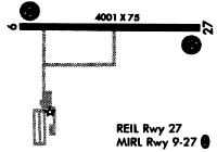
| Runway 09/27 | 4501 ft x 75 ft (1372 m x 23 m) | |
| Runway Length Source: | 3RD PARTY SURVEY as of 01/29/2014 | |
| Surface: | Asphalt - Fair condition - No special surface treatment | |
| Runway Edge Lights: | Medium Intensity | |
Runway Weight Bearing Capacity (in thousands of pounds) |
||
| Single Wheel Landing Gear: | 12.5 | |
Runway 09 |
Runway 27 |
|
Elevation: |
654.0 | 650.7 |
Latitude: |
39-41-59.9062N | 39-42-01.2448N |
Longitude: |
087-40-39.4415W | 087-39-41.8874W |
|
Runway True Alignment: |
088 | 268 |
Glide Path Angle: |
3.0 degrees | 3.1 degrees |
Traffic Pattern: |
Left | Left |
Runway Markings Type: |
Nonprecision Instrument | Nonprecision Instrument |
Runway Markings Condition: |
Poor | Poor |
Visual Glide Slope Indicators: |
Pulsating/Steady Burning VASI On Left Side Of Runway | Pulsating/Steady Burning VASI On Left Side Of Runway |
REIL: |
No | Yes |
Touchdown Lights: |
No | No |
Centerline Lights: |
No | No |
Threshold Crossing Height: |
32 | 26 |
| Runway 18/36 | 3200 ft x 75 ft (975 m x 23 m) | |
| Runway Length Source: | 3RD PARTY SURVEY as of 01/29/2014 | |
| Surface: | Asphalt - Fair condition - No special surface treatment | |
| Runway Edge Lights: | Medium Intensity | |
Runway 18 |
Runway 36 |
|
Elevation: |
645.2 | 654.0 |
Latitude: |
39-42-12.1860N | 39-41-40.5776N |
Longitude: |
087-40-21.1185W | 087-40-19.8846W |
|
Runway True Alignment: |
178 | 358 |
Glide Path Angle: |
3.0 degrees | 3.0 degrees |
Runway Markings Type: |
Nonprecision Instrument | Nonprecision Instrument |
Runway Markings Condition: |
Fair | Fair |
Object at End: |
TREE | |
Object Height: |
45 | |
Distance from End: |
1141 | |
Visual Glide Slope Indicators: |
Pulsating/Steady Burning VASI On Left Side Of Runway | Pulsating/Steady Burning VASI On Left Side Of Runway |
REIL: |
No | No |
Touchdown Lights: |
No | No |
Centerline Lights: |
No | No |
Threshold Crossing Height: |
22 | 22 |
Services
Airframe Repair: |
Major |
Powerplant Repair: |
Major |
Bottled Oxygen: |
None |
Bulk Oxygen: |
None |
Fuel Available: |
100LL, Jet A+ |
Landing Fees: |
No |
Parking: |
Hangars and tiedowns available |
Maps & Diagrams
KPRG Sectional
Flight Planning
at skyvector.com
at skyvector.com