Location
Latitude: |
39-28-40.4000N (39.477889) |
Longitude: |
088-16-47.9000W (-88.279972) |
Elevation: |
722.3 feet MSL (220 m MSL) |
Magnetic Variation: |
3.4 W (as of April 2024 from WMM2020 model) |
Time Zone: |
UTC -6.0 (Standard Time) UTC -5.0 (Daylight Savings Time) |
From City: |
04 N.M. E of Mattoon/Charleston, Illinois |
Found On: |
St Louis Chart |
FAA Region: |
AGL |
Contacts
Manager: |
Publicly owned: |
| ANDREW FEARN 432 AIRPORT ROAD MATTOON, IL 61938 217-234-7120 |
COLES COUNTY AIRPORT AUTHORITY 432 AIRPORT ROAD MATTOON, IL 61938 217-234-7120 |
Operations
Airport Status: |
Operational |
Facility Use: |
Public |
Type: |
Airport |
Activation Date: |
10/1951 |
Control tower: |
No |
Attendance (Months/Days/Hours): |
Months/Days/Hours APR-OCT/M-F/0700-2000 |
Boundary ARTCC: |
ZKC (Kansas City) |
Responsible ARTCC: |
ZAU (Chicago) |
Lighting Schedule: |
SEE RMK |
Segmented Circle Indicator: |
Yes |
Traffic Pattern Altitude (MSL): |
1722 feet (525 m) |
NOTAMs Facility: |
MTO |
NOTAM-D Service: |
Yes |
International Airport of Entry: |
No |
Customs Landing Rights: |
No |
Military Landing Rights: |
Yes |
Civil/Military Joint Use: |
No |
Aircraft Rescue and Firefighting: |
Class IV ARFF Index: A Air Carrier Service: Not Scheduled Certification Date: 05/1973 |
Based Aircraft
| Single Engine: | 41 |
| Multi Engine: | 4 |
| Jet Engine: | 2 |
| GA Helicopters: | 8 |
Annual Operations (as of 12/31/2020)
| Total Operations: | 27050 | |
| Air Taxi: | 2550 | 9.4% |
| GA Local: | 14000 | 51.8% |
| GA Itinerant: | 10000 | 37.0% |
| Military Aircraft: | 500 | 1.8% |
Communications
| CTAF: | 122.700 |
| Unicom: | 122.700 |
| Approach: | CHAMPAIGN 132.85 132.85 CHICAGO ARTCC |
| Departure: | CHAMPAIGN 132.85 132.85 CHICAGO ARTCC |
| ASOS: | 118.475 (217-234-8442) |
- APCH/DEP SVC PRVDD BY CHICAGO ARTCC ON REMOTED CHAMPAIGN APCH CTL FREQS 121.35 & 353.95 (DANVILLE RCAG) WHEN CHAMPAIGN APCH CTL CLSD.
Fixed Based Operators (FBOs) & Fuel
(Click on a business for detail)
Please help us keep this information up to date. This is a FREE SERVICE just like everything else on Airport Guide! If you see that a business needs to be added, modified, or deleted please fill out our Update Form.
To add, modify, or delete a business click here.
Please help us keep this information up to date. This is a FREE SERVICE just like everything else on Airport Guide! If you see that a business needs to be added, modified, or deleted please fill out our Update Form.
Area Code: 217 |
| Business Name | Frequency | Phone | Fuel Grade |
|---|---|---|---|
| Central Illinois Air Corporation
Update FBO info |
Unicom 122.7 | 234-8146 | 100LL, Jet A |
Flight Service Stations
| Primary | Alternate | |
| FSS on Field: | N | |
| FSS Name (ID): | Saint Louis(STL) | |
| Frequency: | ||
| Toll Free Phone: | 1-800-WX-BRIEF |
Instrument Procedures / Charts
FAA Terminal Procedures valid from 0901Z 03/21/24 to 0901Z 04/18/24.
There are various types of charts available for an airport. They are listed in the Page Type column. Here is a legend for those types:
APD - Airport Diagram
DP - Departure Procedure Charts
HOT - Hot Spots
IAP - Instrument Approach Procedure Charts
MIN - Minimums
STAR - Standard Terminal Arrival Charts
| Page Type | Page Name | Volume | Action Since Last Cycle |
|---|---|---|---|
| APD | AIRPORT DIAGRAM | EC-3 | |
| IAP | ILS OR LOC RWY 29 | EC-3 | |
| IAP | RNAV (GPS) RWY 06 | EC-3 | |
| IAP | RNAV (GPS) RWY 11 | EC-3 | |
| IAP | RNAV (GPS) RWY 24 | EC-3 | |
| IAP | RNAV (GPS) RWY 29 | EC-3 | |
| MIN | ALTERNATE MINIMUMS | EC-3 | |
| MIN | TAKEOFF MINIMUMS | EC-3 |
Terminal Procedures are only available for airports in several countries with more being added all the time. If you are looking for a specific country's charts, please send an email to support(at)airportguide.com stating the country name. This will be used to prioritize the implementation.
Navigation Aids (Navaids) near MTO
| Dist (NM) | ID | Morse Code | Name | Type | Freq | True Hdg | Mag Hdg |
|---|---|---|---|---|---|---|---|
| 0.3 | MTO | _ _ _ _ _ _ | Mattoon | DME | 109.4 | 270 | 273 |
| 5.4 | MT | _ _ _ | Zebre | NDB | 347 | 113 | 116 |
| 16.5 | CZB | _ . _ . _ _ . . _ . . . | Casey | NDB | 359 | 128 | 132 |
| 26.5 | SYZ | . . . _ . _ _ _ _ . . | Shelbyville | NDB | 365 | 260 | 263 |
| 29.6 | CM | _ . _ . _ _ | Veals | NDB | 407 | 8 | 11 |
| 30.9 | AXC | . _ _ . . _ _ . _ . | Adders | VORTAC | 117.20 | 300 | 303 |
| 32.8 | DEC | _ . . . _ . _ . | Akley | FAN MARKER | 317 | 320 | |
| 33.4 | CMI | _ . _ . _ _ . . | Champaign | VORTAC | 110.00 | 0 | 3 |
| 34.7 | BIB | _ . . . . . _ . . . | Bible Grove | VORTAC | 109.00 | 195 | 198 |
| 36.2 | HMJ | . . . . _ _ . _ _ _ | Homer | NDB | 281 | 24 | 28 |
| 36.4 | DE | _ . . . | Elwin | NDB | 275 | 301 | 304 |
| 40.3 | RSV | . _ . . . . . . . _ | Robinson | VOR-DME | 108.40 | 133 | 137 |
| 40.7 | PLX | . _ _ . . _ . . _ . . _ | Palestine | NDB | 391 | 132 | 136 |
| 41.2 | HU | . . . . . . _ | Yinno | NDB | 245 | 97 | 101 |
| 44.4 | SIV | . . . . . . . . _ | Sullivan | NDB | 326 | 119 | 123 |
| 45.9 | OLY | _ _ _ . _ . . _ . _ _ | Olney | NDB | 272 | 173 | 176 |
| 47.0 | VLA | . . . _ . _ . . . _ | Vandalia | VOR-DME | 114.30 | 240 | 243 |
| 47.7 | TTH | _ _ . . . . | Terre Haute | VORTAC | 115.30 | 88 | 92 |
| 48.4 | TAZ | _ . _ _ _ . . | Taylorville | NDB | 395 | 274 | 277 |
| 52.9 | LWV | . _ . . . _ _ . . . _ | Lawrenceville | DME | 108.8 | 143 | 147 |
Nearby Airports with Fuel
Notices to Airmen (NOTAMS)
Remarks
| A110-1 | BIRDS ON & INVOF ARPT. |
| A110-3 | ARPT SFC COND NOT MONITORED BTN 2300Z-1300Z. |
| A110-4 | FOR CD CTC CHAMPAIGN APCH AT 217-355-4071, WHEN APCH CLSD CTC CHICAGO ARTCC AT 630-906-8921 |
| A26 | CLSD TO SKEDD ACR OPNS GTR THAN 9 PAX SEATS. UNSCHEDULED ACR OPNS GTR THAN 30 PAX SEATS, 24-HR PPR - CALL AMGR 217-234-7120. |
| A30-18/36 | RWY 18/36 NOT AVBL FOR UNSCHEDULED ACR AT LEAST 31 PASGR SEATS. |
| A42-18 | CORNER STONE MARKERS; LENGTH & WIDTH. |
| A81-APT | ACTVT MALSR RWY 29; REIL RWY 06, 11 & 24; MIRL RWY 06/24 - CTAF. ACTVT HIRL RWY 11/29 & INCR INTST - CTAF. |
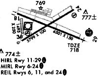
Runways
Runway Summary
| Runways: | 06/24 11/29 18/36 |
| Longest Runway: | 11/29 is 6501 ft (1982 m) long |
| Runways with an Instrument Approach: | 29 |
MTO Airport Runway Details
| Runway 06/24 | 5799 ft x 100 ft (1768 m x 30 m) | |
| Runway Length Source: | 3RD PARTY SURVEY as of 05/21/2010 | |
| Surface: | Asphalt - Good condition - Saw-cut or plastic grooved | |
| Runway Pavement Class: | 23 /F/D/X/U | |
| Runway Edge Lights: | Medium Intensity | |
Runway Weight Bearing Capacity (in thousands of pounds) |
||
| Single Wheel Landing Gear: | 50.0 | |
| Dual Wheel Landing Gear: | 70.0 | |
| Dual Tandem Wheel Landing Gear: | 117.0 | |
Runway 06 |
Runway 24 |
|
Elevation: |
718.8 | 712.1 |
Latitude: |
39-28-26.9089N | 39-28-55.3876N |
Longitude: |
088-17-17.9837W | 088-16-13.8096W |
|
Runway True Alignment: |
060 | 240 |
Glide Path Angle: |
3.0 degrees | 3.0 degrees |
Traffic Pattern: |
Right | Left |
Runway Markings Type: |
Nonprecision Instrument | Nonprecision Instrument |
Runway Markings Condition: |
Good | Good |
Object at End: |
TREE | |
Object Height: |
52 | |
Distance from End: |
2139 | |
Object Centerline Offset: |
103 ft. left of centerline | |
Visual Glide Slope Indicators: |
4-Box VASI On Left Side Of Runway | 4-Box VASI On Left Side Of Runway |
REIL: |
Yes | Yes |
Touchdown Lights: |
No | No |
Centerline Lights: |
No | No |
Threshold Crossing Height: |
41 | 46 |
Declared Distances |
||
Take Off Run Avbl. (TORA): |
5799 | 5799 |
Take Off Distance Avbl. (TODA): |
5799 | 5799 |
Actual Stop Dist. Avbl. (ASDA): |
5799 | 5799 |
Landing Dist. Avbl. (LDA): |
5799 | 5799 |
| Runway 11/29 | 6501 ft x 150 ft (1982 m x 46 m) | |
| Runway Length Source: | 3RD PARTY SURVEY as of 05/21/2010 | |
| Surface: | Asphalt - Good condition - Saw-cut or plastic grooved | |
| Runway Pavement Class: | 51 /F/D/X/U | |
| Runway Edge Lights: | High Intensity | |
Runway Weight Bearing Capacity (in thousands of pounds) |
||
| Single Wheel Landing Gear: | 100.0 | |
| Dual Wheel Landing Gear: | 180.0 | |
| Dual Tandem Wheel Landing Gear: | 280.0 | |
Runway 11 |
Runway 29 |
|
Elevation: |
714.4 | 714.3 |
Latitude: |
39-28-52.5471N | 39-28-27.5300N |
Longitude: |
088-17-22.8762W | 088-16-06.5133W |
|
Runway True Alignment: |
113 | 293 |
ILS Type: |
ILS | |
Glide Path Angle: |
3.0 degrees | 0.0 degrees |
Traffic Pattern: |
Right | Left |
Runway Markings Type: |
Precision Instrument | Precision Instrument |
Runway Markings Condition: |
Fair | Fair |
Object at End: |
TREE | |
Object Height: |
56 | |
Distance from End: |
2592 | |
Object Centerline Offset: |
103 ft. left of centerline | |
Visual Glide Slope Indicators: |
4-Light PAPI On Left Side Of Runway | |
Approach Light System: |
1,400 Foot Medium Intensity Approach Lighting System With Runway Alignment Indicator Lights | |
REIL: |
Yes | No |
Centerline Lights: |
No | No |
Threshold Crossing Height: |
26 | |
Declared Distances |
||
Take Off Run Avbl. (TORA): |
6501 | 6501 |
Take Off Distance Avbl. (TODA): |
6501 | 6501 |
Actual Stop Dist. Avbl. (ASDA): |
6501 | 6501 |
Landing Dist. Avbl. (LDA): |
6501 | 6501 |
| Runway 18/36 | 1098 ft x 250 ft (335 m x 76 m) | |
| Runway Length Source: | 3RD PARTY SURVEY as of 05/21/2010 | |
| Surface: | Asphalt - Good condition - No special surface treatment | |
Runway 18 |
Runway 36 |
|
Elevation: |
714.7 | 718.9 |
Latitude: |
39-28-44.3361N | 39-28-33.5180N |
Longitude: |
088-17-18.2432W | 088-17-17.1284W |
|
Runway True Alignment: |
175 | 355 |
Glide Path Angle: |
0.0 degrees | 0.0 degrees |
Traffic Pattern: |
Right | |
Object Centerline Offset: |
103 ft. left of centerline | |
Declared Distances |
||
Take Off Run Avbl. (TORA): |
1080 | 1080 |
Take Off Distance Avbl. (TODA): |
1080 | 1080 |
Actual Stop Dist. Avbl. (ASDA): |
1080 | 1080 |
Landing Dist. Avbl. (LDA): |
1080 | 1080 |
Services
Airframe Repair: |
Minor |
Powerplant Repair: |
Minor |
Bottled Oxygen: |
None |
Bulk Oxygen: |
None |
Fuel Available: |
100LL, Mogas |
Landing Fees: |
No |
Parking: |
Hangars and tiedowns available |
Maps & Diagrams
MTO Sectional
Flight Planning
at skyvector.com
at skyvector.com