Location
Latitude: |
44-07-28.5000N (44.124583) |
Longitude: |
123-12-43.1000W (-123.211972) |
Elevation: |
373.7 feet MSL (114 m MSL) |
Magnetic Variation: |
14.6 E (as of May 2024 from WMM2020 model) |
Time Zone: |
UTC -8.0 (Standard Time) UTC -7.0 (Daylight Savings Time) |
From City: |
07 N.M. NW of Eugene, Oregon |
Found On: |
Klamath Falls Chart |
FAA Region: |
ANM |
Contacts
Manager: |
Publicly owned: |
| CATHRYN STEPHENS 28855 LOCKHEED DRIVE EUGENE, OR 97402 541-682-5430 |
CITY OF EUGENE 125 E. 8TH EUGENE, OR 97401 (541) 682-5010 |
Operations
Airport Status: |
Operational |
Facility Use: |
Public |
Type: |
Airport |
Activation Date: |
02/1943 |
Control tower: |
Yes |
Attendance (Months/Days/Hours): |
Months/Days/Hours ALL/ALL/ALL |
Boundary ARTCC: |
ZSE (Seattle) |
Responsible ARTCC: |
ZSE (Seattle) |
Lighting Schedule: |
SEE RMK |
Segmented Circle Indicator: |
Yes |
Traffic Pattern Altitude (MSL): |
1374 feet (419 m) |
NOTAMs Facility: |
EUG |
NOTAM-D Service: |
Yes |
International Airport of Entry: |
No |
Customs Landing Rights: |
No |
Military Landing Rights: |
Yes |
Civil/Military Joint Use: |
No |
Aircraft Rescue and Firefighting: |
Class I ARFF Index: C Air Carrier Service: Scheduled Certification Date: 05/1973 |
Based Aircraft
| Single Engine: | 88 |
| Multi Engine: | 14 |
| Jet Engine: | 9 |
| GA Helicopters: | 8 |
Annual Operations (as of 12/31/2018)
| Total Operations: | 64393 | |
| Commercial: | 8658 | 13.4% |
| Air Taxi: | 10125 | 15.7% |
| GA Local: | 15560 | 24.2% |
| GA Itinerant: | 22470 | 34.9% |
| Military Aircraft: | 7580 | 11.8% |
Communications
| CTAF: | 118.900 |
| Unicom: | 122.950 |
| Tower: | EUGENE 118.9 ;RWY 16R/34L 124.15 ;RWY 16L/34R 371.9 Hrs: 0600-2330 |
| Clearance Del.: | 121.7 269.5 |
| Ground: | 121.7 269.5 |
| Approach: | CASCADE 119.6 ;340-159 120.25 ;160-339 298.9 ;160-339 348.7 ;340-159 Hrs: 0600-2330 SEATTLE ARTCC Hrs: 2330-0600 |
| Departure: | CASCADE 119.6 ;340-159 120.25 ;160-339 298.9 ;160-339 348.7 ;340-159 Hrs: 0600-2330 SEATTLE ARTCC Hrs: 2330-0600 |
| ATIS: | 125.225 Hrs: 24 |
| ASOS: | (541-461-3114) |
| EMERG: | 121.5 |
| EMERG: | 243.0 |
- APCH/DEP CTL SVC PRVDD BY SEATTLE ARTCC (ZSE) ON FREQS 125.8/291.7 (HORTON RCAG) WHEN CASCADE APCH CTL (EUG) CLSD.
Fixed Based Operators (FBOs) & Fuel
(Click on a business for detail)
Please help us keep this information up to date. This is a FREE SERVICE just like everything else on Airport Guide! If you see that a business needs to be added, modified, or deleted please fill out our Update Form.
To add, modify, or delete a business click here.
Please help us keep this information up to date. This is a FREE SERVICE just like everything else on Airport Guide! If you see that a business needs to be added, modified, or deleted please fill out our Update Form.
Area Code: 541 |
| Business Name | Frequency | Phone | Fuel Grade |
|---|---|---|---|
| Flightcraft, Inc.
Update FBO info |
122.95 | 688-9291, for parts 800-457-7889 | 100LL, Jet A |
| Friendly Air Service
Update FBO info |
461-1605 | ||
| Lawrence Air Service
Update FBO info |
Unicom 122.95 | 689-3331 | |
| Oregon Air and Space Museum
Update FBO info |
461-1101 |
Flight Service Stations
| Primary | Alternate | |
| FSS on Field: | N | |
| FSS Name (ID): | Mc Minnville(MMV) | |
| Frequency: | ||
| Toll Free Phone: | 1-800-WX-BRIEF |
Instrument Procedures / Charts
FAA Terminal Procedures valid from 0901Z 03/21/24 to 0901Z 04/18/24.
There are various types of charts available for an airport. They are listed in the Page Type column. Here is a legend for those types:
APD - Airport Diagram
DP - Departure Procedure Charts
HOT - Hot Spots
IAP - Instrument Approach Procedure Charts
MIN - Minimums
STAR - Standard Terminal Arrival Charts
| Page Type | Page Name | Volume | Action Since Last Cycle |
|---|---|---|---|
| APD | AIRPORT DIAGRAM | NW-1 | |
| DP | EUGENE ONE | NW-1 | |
| IAP | ILS OR LOC RWY 16L | NW-1 | |
| IAP | ILS OR LOC RWY 16R | NW-1 | |
| IAP | ILS RWY 16R (CAT II - III) | NW-1 | |
| IAP | ILS RWY 16R (SA CAT I) | NW-1 | |
| IAP | RNAV (GPS) Y RWY 16L | NW-1 | |
| IAP | RNAV (GPS) Y RWY 16R | NW-1 | |
| IAP | RNAV (GPS) Y RWY 34L | NW-1 | |
| IAP | RNAV (GPS) Y RWY 34R | NW-1 | |
| IAP | RNAV (RNP) Z RWY 16L | NW-1 | |
| IAP | RNAV (RNP) Z RWY 16R | NW-1 | |
| IAP | RNAV (RNP) Z RWY 34L | NW-1 | |
| IAP | RNAV (RNP) Z RWY 34R | NW-1 | |
| IAP | VOR OR TACAN RWY 34L | NW-1 | |
| MIN | ALTERNATE MINIMUMS | NW-1 | |
| MIN | TAKEOFF MINIMUMS | NW-1 |
Terminal Procedures are only available for airports in several countries with more being added all the time. If you are looking for a specific country's charts, please send an email to support(at)airportguide.com stating the country name. This will be used to prioritize the implementation.
Navigation Aids (Navaids) near EUG
| Dist (NM) | ID | Morse Code | Name | Type | Freq | True Hdg | Mag Hdg |
|---|---|---|---|---|---|---|---|
| 0.5 | EUG | . . . _ _ _ . | Eugene | VORTAC | 112.90 | 244 | 229 |
| 5.3 | EU | . . . _ | Frakk | NDB | 260 | 356 | 341 |
| 22.8 | CVO | _ . _ . . . . _ _ _ _ | Corvallis | VOR-DME | 115.40 | 351 | 336 |
| 29.4 | LWG | . _ . . . _ _ _ _ . | Lewisburg | NDB | 225 | 355 | 340 |
| 44.8 | SL | . . . . _ . . | Turno | NDB | 266 | 14 | 359 |
| 45.4 | ONP | _ _ _ _ . . _ _ . | Newport | VORTAC | 117.10 | 306 | 291 |
| 53.7 | RBG | . _ . _ . . . _ _ . | Roseburg | NDB | 400 | 186 | 172 |
| 56.9 | RBG | . _ . _ . . . _ _ . | Roseburg | VOR-DME | 108.20 | 186 | 172 |
| 59.4 | OTH | _ _ _ _ . . . . | North Bend | VOR-DME | 112.10 | 224 | 209 |
| 64.7 | OT | _ _ _ _ | Emire | NDB | 378 | 227 | 212 |
| 74.4 | UBG | . . _ _ . . . _ _ . | Newberg | VOR-DME | 117.40 | 7 | 352 |
| 82.5 | DSD | _ . . . . . _ . . | Deschutes | VORTAC | 117.60 | 83 | 69 |
| 85.7 | HIO | . . . . . . _ _ _ | Hillsboro | VOT | 115.20 | 7 | 352 |
| 90.6 | PND | . _ _ . _ . _ . . | Banks | NDB | 356 | 4 | 349 |
| 90.8 | LBH | . _ . . _ . . . . . . . | Laker | NDB | 332 | 20 | 5 |
| 91.5 | CBU | _ . _ . _ . . . . . _ | Columbia | TACAN | 109.20 | 16 | 1 |
| 91.8 | PDX | . _ _ . _ . . _ . . _ | Portland | VOR-DME | 111.80 | 16 | 1 |
| 92.0 | PDX | . _ _ . _ . . _ . . _ | Portland | VOT | 111.00 | 16 | 1 |
| 94.9 | RD | . _ . _ . . | Bodey | NDB | 411 | 82 | 68 |
| 99.6 | OED | _ _ _ . _ . . | Rogue Valley | VORTAC | 113.60 | 172 | 158 |
Nearby Airports with Fuel
Notices to Airmen (NOTAMS)
Remarks
| A110-2 | MIGRATORY WATERFOWL & OTR BIRDS ON & INVOF ARPT. |
| A110-3 | TWYS H & K UNAVBL TO ACFT 21000 LBS SW & 40000 LBS DW GWT. |
| A110-5 | TRML APRON CLSD TO ACFT EXCP SKEDD ACRS & FLTS WITH PRIOR PMSN. |
| A110-7 | HELS LNDG AND DEPARTING AVOID OVERFLYING THE AIRLINE PSGR TRML AND RAMP LCTD E OF RY 16R/34L. |
| A110-8 | NO ACES TO RWY 34L BYD TWY A6. |
| A110-9 | FOR CD IF UNA TO CTC ON FSS FREQ, CTC SEATTLE ARTCC AT 253-351-3694. |
| A26 | PPR FOR UNSKED ACR OPNS WITH MORE THAN 30 PSGR SEATS CALL 541-682-5430. ARFF AVBL 24 HRS A DAY, 7 DAYS A WEEK, 365 DAYS A YEAR. |
| A81-APT | PAPI RYS 16R & 16L & 34R & VASI RY 34L OPER 24 HRS. WHEN ATCT CLSD HIRL RYS 16L/34R & 16R/34L PRE-SET MED INTST. WHEN ATCT CLSD ACTVT ALSF2 RY 16R, ODALS RY 34L, MALSR RY 16L & REIL RY 34R - CTAF. |
Runways
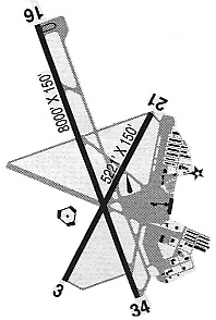
Runway Summary
| Runways: | 16L/34R 16R/34L |
| Longest Runway: | 16R/34L is 8009 ft (2441 m) long |
| Runways with an Instrument Approach: | 16L, 16R |
EUG Airport Runway Details
| Runway 16L/34R | 6000 ft x 150 ft (1829 m x 46 m) | |
| Runway Length Source: | 3RD PARTY SURVEY as of 07/19/2016 | |
| Surface: | Asphalt - Good condition - Saw-cut or plastic grooved | |
| Runway Pavement Class: | 60 /F/C/X/T | |
| Runway Edge Lights: | High Intensity | |
Runway Weight Bearing Capacity (in thousands of pounds) |
||
| Single Wheel Landing Gear: | 120.0 | |
| Dual Wheel Landing Gear: | 211.0 | |
| Dual Tandem Wheel Landing Gear: | 342.0 | |
Runway 16L |
Runway 34R |
|
Elevation: |
363.5 | 373.6 |
Latitude: |
44-07-58.7079N | 44-06-59.4616N |
Longitude: |
123-12-09.8249W | 123-12-08.9466W |
|
Runway True Alignment: |
179 | 359 |
ILS Type: |
ILS/DME | |
Glide Path Angle: |
3.0 degrees | 3.0 degrees |
Runway Markings Type: |
Precision Instrument | Precision Instrument |
Runway Markings Condition: |
Good | Good |
Visual Glide Slope Indicators: |
4-Light PAPI On Left Side Of Runway | 4-Light PAPI On Left Side Of Runway |
Approach Light System: |
1,400 Foot Medium Intensity Approach Lighting System With Runway Alignment Indicator Lights | |
REIL: |
Yes | |
Threshold Crossing Height: |
52 | 50 |
Declared Distances |
||
Take Off Run Avbl. (TORA): |
6000 | 6000 |
Take Off Distance Avbl. (TODA): |
6000 | 6000 |
Actual Stop Dist. Avbl. (ASDA): |
6000 | 6000 |
Landing Dist. Avbl. (LDA): |
6000 | 6000 |
| Runway 16R/34L | 8009 ft x 150 ft (2441 m x 46 m) | |
| Runway Length Source: | 3RD PARTY SURVEY as of 07/19/2016 | |
| Surface: | Asphalt - Good condition - Saw-cut or plastic grooved | |
| Runway Pavement Class: | 90 /F/C/X/T | |
| Runway Edge Lights: | High Intensity | |
Runway Weight Bearing Capacity (in thousands of pounds) |
||
| Single Wheel Landing Gear: | 120.0 | |
| Dual Wheel Landing Gear: | 250.0 | |
| Dual Tandem Wheel Landing Gear: | 550.0 | |
Runway 16R |
Runway 34L |
|
Elevation: |
360.2 | 365.5 |
Latitude: |
44-08-07.6148N | 44-06-48.5269N |
Longitude: |
123-13-08.9328W | 123-13-07.7376W |
|
Runway True Alignment: |
179 | 359 |
ILS Type: |
ILS/DME | |
Glide Path Angle: |
3.0 degrees | 3.0 degrees |
Traffic Pattern: |
Left | Left |
Runway Markings Type: |
Precision Instrument | Precision Instrument |
Runway Markings Condition: |
Good | Good |
Visual Glide Slope Indicators: |
4-Light PAPI On Left Side Of Runway | 4-Box VASI On Left Side Of Runway |
Runway Visual Range (RVR): |
Touchdown, Midfield, Rollout | Touchdown, Midfield, Rollout |
Approach Light System: |
Standard 2,400 Foot High Intensity Approach Lighting System With Sequenced Flashers, Cat. II or III Config. | Omnidirectional Approach Lighting System |
Touchdown Lights: |
Yes | No |
Centerline Lights: |
Yes | Yes |
Threshold Crossing Height: |
50 | 53 |
Declared Distances |
||
Take Off Run Avbl. (TORA): |
8009 | 8009 |
Take Off Distance Avbl. (TODA): |
8009 | 8009 |
Actual Stop Dist. Avbl. (ASDA): |
8009 | 8009 |
Landing Dist. Avbl. (LDA): |
8009 | 8009 |
Services
Airframe Repair: |
Major |
Powerplant Repair: |
Minor |
Bottled Oxygen: |
None |
Bulk Oxygen: |
None |
Fuel Available: |
100LL |
Landing Fees: |
No |
Parking: |
Tiedowns available |
Maps & Diagrams
EUG Sectional
Flight Planning
at skyvector.com
at skyvector.com