Location
Latitude: |
44-52-01.7456N (44.867151) |
Longitude: |
123-11-53.6821W (-123.198245) |
Elevation: |
179.5 feet MSL (55 m MSL) |
Magnetic Variation: |
14.7 E (as of April 2024 from WMM2020 model) |
Time Zone: |
UTC -8.0 (Standard Time) UTC -7.0 (Daylight Savings Time) |
From City: |
01 N.M. NW of Independence, Oregon |
Found On: |
Seattle Chart |
FAA Region: |
ANM |
Contacts
Manager: |
Publicly owned: |
| STATE AIRPORTS MANAGER 3040 25TH ST SE SALEM, OR 97302-1125 (503) 378-4880 |
OREGON DEPARTMENT OF AVIATION 3040 25TH ST SE SALEM, OR 97302 503-378-8689 |
Operations
Airport Status: |
Operational |
Facility Use: |
Public |
Type: |
Airport |
Control tower: |
No |
Attendance (Months/Days/Hours): |
Months/Days/Hours ALL/ALL/DALGT |
Boundary ARTCC: |
ZSE (Seattle) |
Responsible ARTCC: |
ZSE (Seattle) |
Lighting Schedule: |
SEE RMK |
Segmented Circle Indicator: |
Yes |
Traffic Pattern Altitude (MSL): |
1180 feet (360 m) |
NOTAMs Facility: |
MMV |
NOTAM-D Service: |
Yes |
International Airport of Entry: |
No |
Customs Landing Rights: |
No |
Military Landing Rights: |
Yes |
Civil/Military Joint Use: |
No |
Based Aircraft
| Single Engine: | 164 |
| Multi Engine: | 4 |
| Gliders: | 5 |
Annual Operations (as of 10/22/2019)
| Total Operations: | 33658 | |
| Air Taxi: | 1121 | 3.3% |
| GA Local: | 8995 | 26.7% |
| GA Itinerant: | 23542 | 69.9% |
Communications
| CTAF: | 122.975 |
| Unicom: | 122.975 |
Fixed Based Operators (FBOs) & Fuel
(Click on a business for detail)
Please help us keep this information up to date. This is a FREE SERVICE just like everything else on Airport Guide! If you see that a business needs to be added, modified, or deleted please fill out our Update Form.
To add, modify, or delete a business click here.
Please help us keep this information up to date. This is a FREE SERVICE just like everything else on Airport Guide! If you see that a business needs to be added, modified, or deleted please fill out our Update Form.
Area Code: 503 |
| Business Name | Frequency | Phone | Fuel Grade |
|---|---|---|---|
| Halh Aviation
Update FBO info |
838-5246 | ||
| HB Aviation Service
Update FBO info |
838-4643 | 80, 100LL | |
| Mac's Aircraft Service
Update FBO info |
838-0164 |
Flight Service Stations
| Primary | Alternate | |
| FSS on Field: | N | |
| FSS Name (ID): | Mc Minnville(MMV) | |
| Frequency: | ||
| Toll Free Phone: | 1-800-WX-BRIEF |
Instrument Procedures / Charts
Terminal Procedures are only available for airports in several countries with more being added all the time. If you are looking for a specific country's charts, please send an email to support(at)airportguide.com stating the country name. This will be used to prioritize the implementation.
Navigation Aids (Navaids) near 7S5
| Dist (NM) | ID | Morse Code | Name | Type | Freq | True Hdg | Mag Hdg |
|---|---|---|---|---|---|---|---|
| 10.6 | SL | . . . . _ . . | Turno | NDB | 266 | 96 | 81 |
| 15.5 | LWG | . _ . . . _ _ _ _ . | Lewisburg | NDB | 225 | 191 | 176 |
| 22.4 | CVO | _ . _ . . . . _ _ _ _ | Corvallis | VOR-DME | 115.40 | 190 | 175 |
| 30.6 | UBG | . . _ _ . . . _ _ . | Newberg | VOR-DME | 117.40 | 17 | 2 |
| 39.3 | EU | . . . _ | Frakk | NDB | 260 | 181 | 166 |
| 40.7 | ONP | _ _ _ _ . . _ _ . | Newport | VORTAC | 117.10 | 244 | 229 |
| 41.8 | HIO | . . . . . . _ _ _ | Hillsboro | VOT | 115.20 | 14 | 359 |
| 44.8 | EUG | . . . _ _ _ . | Eugene | VORTAC | 112.90 | 181 | 166 |
| 46.2 | PND | . _ _ . _ . _ . . | Banks | NDB | 356 | 7 | 352 |
| 49.9 | CBU | _ . _ . _ . . . . . _ | Columbia | TACAN | 109.20 | 29 | 14 |
| 50.3 | PDX | . _ _ . _ . . _ . . _ | Portland | VOR-DME | 111.80 | 29 | 14 |
| 50.5 | PDX | . _ _ . _ . . _ . . _ | Portland | VOT | 111.00 | 29 | 14 |
| 51.0 | LBH | . _ . . _ . . . . . . . | Laker | NDB | 332 | 37 | 22 |
| 58.7 | BTG | _ . . . _ _ _ . | Battle Ground | VORTAC | 116.60 | 25 | 10 |
| 78.1 | PEN | . _ _ . . _ . | Karpen | NDB | 201 | 348 | 333 |
| 78.2 | LSO | . _ . . . . . _ _ _ | Kelso | NDB | 256 | 8 | 353 |
| 82.8 | AST | . _ . . . _ | Astoria | VOR-DME | 114.00 | 339 | 324 |
| 86.7 | AST | . _ . . . _ | Fort Stevens | FAN MARKER | 338 | 323 | |
| 89.0 | DSD | _ . . . . . _ . . | Deschutes | VORTAC | 117.60 | 113 | 99 |
| 96.6 | OTH | _ _ _ _ . . . . | North Bend | VOR-DME | 112.10 | 205 | 190 |
Nearby Airports with Fuel
Notices to Airmen (NOTAMS)
Remarks
| A110-1 | ULTRALIGHT ACFT ON AND INVOF ARPT. |
| A110-2 | MIGRATORY FLOCKS OF WATERFOWL ON AND INVOF ARPT. |
| A110-3 | GLDR & ULTRALIGHTS USE R TFC FOR RWY 16/34. |
| A110-4 | FOR CD CTC SEATTLE ARTCC AT 253-351-3694. |
| A110-5 | CALM WIND USE RWY 34. |
| A110-6 | SEASONAL STANDING WATER ON TWYS. |
| A81-APT | ACTVT PAPI RWY 16 & 34; MIRL RWY 16/34 - CTAF. |
Runways
Runway Summary
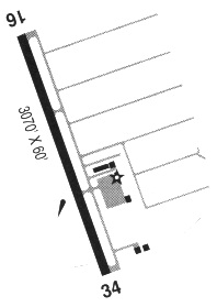
| Runways: | 16/34 |
| Longest Runway: | 16/34 is 3002 ft (915 m) long |
| Runways with an Instrument Approach: |
7S5 Airport Runway Details
| Runway 16/34 | 3002 ft x 60 ft (915 m x 18 m) | |
| Runway Length Source: | 3RD PARTY SURVEY as of 11/07/2018 | |
| Surface: | Asphalt - Good condition - No special surface treatment | |
| Runway Edge Lights: | Medium Intensity | |
Runway Weight Bearing Capacity (in thousands of pounds) |
||
| Single Wheel Landing Gear: | 12.5 | |
Runway 16 |
Runway 34 |
|
Elevation: |
179.1 | 178.1 |
Latitude: |
44-52-16.5670N | 44-51-46.9242N |
Longitude: |
123-11-53.7225W | 123-11-53.6417W |
|
Runway True Alignment: |
180 | 360 |
Glide Path Angle: |
3.0 degrees | 3.0 degrees |
Traffic Pattern: |
Left | Left |
Runway Markings Type: |
Basic | Basic |
Runway Markings Condition: |
Good | Good |
Object at End: |
ROAD | |
Object Height: |
15 | |
Distance from End: |
585 | |
Object Centerline Offset: |
175 ft. left of centerline | |
Visual Glide Slope Indicators: |
4-Light PAPI On Right Side Of Runway | 4-Light PAPI On Left Side Of Runway |
Threshold Crossing Height: |
40 | 40 |
Services
Airframe Repair: |
Major |
Powerplant Repair: |
Major |
Bottled Oxygen: |
None |
Bulk Oxygen: |
None |
Fuel Available: |
100LL, Jet A |
Landing Fees: |
No |
Parking: |
Tiedowns available |
Maps & Diagrams
7S5 Sectional
Flight Planning
at skyvector.com
at skyvector.com