Location
Latitude: |
43-25-01.0000N (43.416944) |
Longitude: |
124-14-49.3000W (-124.247028) |
Elevation: |
17.4 feet MSL (5 m MSL) |
Magnetic Variation: |
14.6 E (as of April 2024 from WMM2020 model) |
Time Zone: |
UTC -8.0 (Standard Time) UTC -7.0 (Daylight Savings Time) |
From City: |
01 N.M. NW of North Bend, Oregon |
Found On: |
Klamath Falls Chart |
FAA Region: |
ANM |
Contacts
Manager: |
Publicly owned: |
| RODGER CRADDOCK 1100 AIRPORT LANE, FLOOR 3 NORTH BEND, OR 97459-2079 541-756-8531 |
COOS COUNTY AIRPORT DISTRICT 1100 AIRPORT LANE, FLOOR 3 NORTH BEND, OR 97459-2079 541-756-8500 |
Operations
Airport Status: |
Operational |
Facility Use: |
Public |
Type: |
Airport |
Activation Date: |
01/1940 |
Control tower: |
Yes |
Attendance (Months/Days/Hours): |
Months/Days/Hours ALL/ALL/0500-2100 |
Boundary ARTCC: |
ZSE (Seattle) |
Responsible ARTCC: |
ZSE (Seattle) |
Lighting Schedule: |
SEE RMK |
Segmented Circle Indicator: |
Yes |
Traffic Pattern Altitude (MSL): |
1017 feet (310 m) |
NOTAMs Facility: |
OTH |
NOTAM-D Service: |
Yes |
International Airport of Entry: |
No |
Customs Landing Rights: |
No |
Military Landing Rights: |
Yes |
Civil/Military Joint Use: |
No |
Aircraft Rescue and Firefighting: |
Class I ARFF Index: A Air Carrier Service: Scheduled Certification Date: 05/1973 |
Based Aircraft
| Single Engine: | 36 |
| Multi Engine: | 8 |
| Jet Engine: | 1 |
| GA Helicopters: | 6 |
| Military Aircraft: | 5 |
Annual Operations (as of 12/31/2018)
| Total Operations: | 18549 | |
| Commercial: | 67 | 0.4% |
| Air Taxi: | 7058 | 38.1% |
| GA Local: | 1948 | 10.5% |
| GA Itinerant: | 4036 | 21.8% |
| Military Aircraft: | 5440 | 29.3% |
Communications
| CTAF: | 118.450 |
| Tower: | NORTH BEND 118.45 Hrs: 0700-2100 |
| Ground: | 127.1 |
| Approach: | SEATTLE ARTCC |
| Departure: | SEATTLE ARTCC |
| AWOS-3PT: | 135.075 (541-756-0135) |
- APCH/DEP CTL SVC PRVDD BY SEATTLE ARTCC (ZSE) ON FREQS 127.55/254.35 (HORTON RCAG).
Fixed Based Operators (FBOs) & Fuel
(Click on a business for detail)
Please help us keep this information up to date. This is a FREE SERVICE just like everything else on Airport Guide! If you see that a business needs to be added, modified, or deleted please fill out our Update Form.
To add, modify, or delete a business click here.
Please help us keep this information up to date. This is a FREE SERVICE just like everything else on Airport Guide! If you see that a business needs to be added, modified, or deleted please fill out our Update Form.
Area Code: 541 |
| Business Name | Frequency | Phone | Fuel Grade |
|---|---|---|---|
| Coos Aviation
Update FBO info |
756-5181 | 100LL, Jet A | |
| Pegasus Air
Update FBO info |
Unicom 122.85 | 756-5727 | 100LL, Jet A |
Flight Service Stations
| Primary | Alternate | |
| FSS on Field: | N | |
| FSS Name (ID): | Mc Minnville(MMV) | |
| Frequency: | ||
| Toll Free Phone: | 1-800-WX-BRIEF |
Instrument Procedures / Charts
FAA Terminal Procedures valid from 0901Z 03/21/24 to 0901Z 04/18/24.
There are various types of charts available for an airport. They are listed in the Page Type column. Here is a legend for those types:
APD - Airport Diagram
DP - Departure Procedure Charts
HOT - Hot Spots
IAP - Instrument Approach Procedure Charts
MIN - Minimums
STAR - Standard Terminal Arrival Charts
| Page Type | Page Name | Volume | Action Since Last Cycle |
|---|---|---|---|
| APD | AIRPORT DIAGRAM | NW-1 | |
| DP | NORTH BEND SEVEN | NW-1 | |
| HOT | HOT SPOT | NW-1 | |
| IAP | COPTER ILS OR LOC RWY 05 | NW-1 | |
| IAP | ILS OR LOC RWY 05 | NW-1 | |
| IAP | RNAV (GPS) Y RWY 05 | NW-1 | |
| IAP | RNAV (RNP) Z RWY 05 | NW-1 | |
| IAP | VOR-B | NW-1 | |
| MIN | ALTERNATE MINIMUMS | NW-1 | |
| MIN | TAKEOFF MINIMUMS | NW-1 |
Terminal Procedures are only available for airports in several countries with more being added all the time. If you are looking for a specific country's charts, please send an email to support(at)airportguide.com stating the country name. This will be used to prioritize the implementation.
Navigation Aids (Navaids) near OTH
| Dist (NM) | ID | Morse Code | Name | Type | Freq | True Hdg | Mag Hdg |
|---|---|---|---|---|---|---|---|
| 3.1 | OT | _ _ _ _ | Emire | NDB | 378 | 243 | 228 |
| 3.4 | OTH | _ _ _ _ . . . . | North Bend | VOR-DME | 112.10 | 91 | 76 |
| 40.3 | RBG | . _ . _ . . . _ _ . | Roseburg | NDB | 400 | 105 | 91 |
| 41.5 | RBG | . _ . _ . . . _ _ . | Roseburg | VOR-DME | 108.20 | 109 | 95 |
| 61.3 | EUG | . . . _ _ _ . | Eugene | VORTAC | 112.90 | 46 | 31 |
| 65.2 | EU | . . . _ | Frakk | NDB | 260 | 42 | 27 |
| 70.0 | ONP | _ _ _ _ . . _ _ . | Newport | VORTAC | 117.10 | 6 | 351 |
| 76.9 | CVO | _ . _ . . . . _ _ _ _ | Corvallis | VOR-DME | 115.40 | 32 | 17 |
| 81.2 | OED | _ _ _ . _ . . | Rogue Valley | VORTAC | 113.60 | 133 | 119 |
| 83.2 | LWG | . _ . . . _ _ _ _ . | Lewisburg | NDB | 225 | 30 | 15 |
| 86.0 | MEF | _ _ . . . _ . | Medford | NDB | 356 | 135 | 121 |
| 87.8 | MFR | _ _ . . _ . . _ . | Medford | VOT | 117.20 | 135 | 121 |
| 98.2 | CEC | _ . _ . . _ . _ . | Crescent City | VORTAC | 109.00 | 179 | 165 |
Nearby Airports with Fuel
Notices to Airmen (NOTAMS)
Remarks
| A110-1 | SHIP CHNL XS RWY 05 APRX 2/3 MI FM THLD; XS RWY 13 & RWY 23 APRX 1000 FT TO 1700 FT FM THLD; MAST HGTS TO 144 FT. |
| A110-2 | MIGRATORY FLOCKS OF WATERFOWL ON & INVOF ARPT. |
| A110-3 | ALL ACFT SUBJECTED TO ARPT USAGE FEES. |
| A110-4 | PAEW INVOF RYS AND TWYS 0730-1530. |
| A110-5 | TWY A3 CLSD TO ACFT OVER 60,000 LBS INDEFLY. |
| A110-6 | FOR CD IF UNA TO CTC ON FSS FREQ, CTC SEATTLE ARTCC AT 253-351-3694. |
| A17 | SVC AVBL 0800-1700, FOR SVC AFT HRS CALL (541) 756-5181. |
| A43-31 | P4L OTS INDEFINITELY |
| A81-APT | WHEN ATCT CLSD, ACTVT MALSR RWY 05; REIL RWYS 13, 23, 31; MIRL RWY 13/31; HIRL 05/23 - CTAF. PAPI RWY 05 OPR CONSLY. |
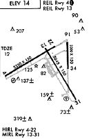
Runways
Runway Summary
| Runways: | 05/23 13/31 |
| Longest Runway: | 05/23 is 5980 ft (1823 m) long |
| Runways with an Instrument Approach: | 05 |
OTH Airport Runway Details
| Runway 05/23 | 5980 ft x 150 ft (1823 m x 46 m) | |
| Runway Length Source: | 3RD PARTY SURVEY as of 05/22/2008 | |
| Surface: | Asphalt - Good condition - Saw-cut or plastic grooved | |
| Runway Pavement Class: | 62 /F/B/W/T | |
| Runway Edge Lights: | High Intensity | |
Runway Weight Bearing Capacity (in thousands of pounds) |
||
| Single Wheel Landing Gear: | 120.0 | |
| Dual Wheel Landing Gear: | 215.0 | |
| Dual Tandem Wheel Landing Gear: | 340.0 | |
| Dual Dual Tandem Wheel Landing Gear: | 800.0 | |
Runway 05 |
Runway 23 |
|
Elevation: |
16.1 | 13.4 |
Latitude: |
43-24-53.0248N | 43-25-21.9530N |
Longitude: |
124-15-38.1524W | 124-14-27.5125W |
|
Runway True Alignment: |
061 | 241 |
ILS Type: |
ILS/DME | |
Glide Path Angle: |
3.0 degrees | 0.0 degrees |
Traffic Pattern: |
Left | Left |
Runway Markings Type: |
Precision Instrument | Precision Instrument |
Runway Markings Condition: |
Fair | Fair |
Object at End: |
BOAT | BOAT |
Object Height: |
144 | 144 |
Distance from End: |
3700 | 1320 |
Object Centerline Offset: |
550 ft. right of centerline | |
Visual Glide Slope Indicators: |
4-Light PAPI On Right Side Of Runway | |
Approach Light System: |
1,400 Foot Medium Intensity Approach Lighting System With Runway Alignment Indicator Lights | |
REIL: |
No | Yes |
Threshold Crossing Height: |
51 | |
Threshold Elevation: |
13.3 | |
Displaced Threshold: |
660 | |
Threshold Latitude: |
43-25-18.7612N | |
Threshold Longitude: |
124-14-35.3121W | |
Declared Distances |
||
Take Off Run Avbl. (TORA): |
5320 | 5980 |
Take Off Distance Avbl. (TODA): |
5320 | 5980 |
Actual Stop Dist. Avbl. (ASDA): |
5320 | 5980 |
Landing Dist. Avbl. (LDA): |
5320 | 5320 |
| Runway 13/31 | 4470 ft x 150 ft (1362 m x 46 m) | |
| Runway Length Source: | 3RD PARTY SURVEY as of 05/22/2008 | |
| Surface: | Asphalt - Good condition - Saw-cut or plastic grooved | |
| Runway Pavement Class: | 55 /F/C/W/T | |
| Runway Edge Lights: | Medium Intensity | |
Runway Weight Bearing Capacity (in thousands of pounds) |
||
| Single Wheel Landing Gear: | 120.0 | |
| Dual Wheel Landing Gear: | 190.0 | |
| Dual Tandem Wheel Landing Gear: | 305.0 | |
| Dual Dual Tandem Wheel Landing Gear: | 735.0 | |
Runway 13 |
Runway 31 |
|
Elevation: |
13.1 | 17.4 |
Latitude: |
43-25-11.4296N | 43-24-33.3378N |
Longitude: |
124-14-46.4599W | 124-14-15.8456W |
|
Runway True Alignment: |
150 | 330 |
Glide Path Angle: |
0.0 degrees | 4.0 degrees |
Traffic Pattern: |
Left | Right |
Runway Markings Type: |
Basic | Basic |
Runway Markings Condition: |
Good | Good |
Object at End: |
BOAT | ROAD |
Object Height: |
144 | 13 |
Distance from End: |
1740 | 200 |
Object Centerline Offset: |
550 ft. right of centerline | |
Visual Glide Slope Indicators: |
4-Light PAPI On Left Side Of Runway | |
REIL: |
Yes | Yes |
Threshold Crossing Height: |
50 | |
Declared Distances |
||
Take Off Run Avbl. (TORA): |
4470 | 4470 |
Take Off Distance Avbl. (TODA): |
4470 | 4470 |
Actual Stop Dist. Avbl. (ASDA): |
4470 | 4470 |
Landing Dist. Avbl. (LDA): |
4470 | 4470 |
Services
Airframe Repair: |
Minor |
Powerplant Repair: |
Minor |
Bottled Oxygen: |
None |
Bulk Oxygen: |
None |
Fuel Available: |
100LL, Jet A |
Landing Fees: |
No |
Parking: |
Tiedowns available |
Maps & Diagrams
OTH Sectional
Flight Planning
at skyvector.com
at skyvector.com