Location
Latitude: |
45-25-42.4210N (45.42845) |
Longitude: |
122-56-31.7650W (-122.942157) |
Elevation: |
170.0 feet MSL (52 m MSL) |
Magnetic Variation: |
14.8 E (as of April 2024 from WMM2020 model) |
Time Zone: |
UTC -8.0 (Standard Time) UTC -7.0 (Daylight Savings Time) |
From City: |
04 N.M. S of Hillsboro, Oregon |
Found On: |
Seattle Chart |
FAA Region: |
ANM |
Contacts
Manager: |
Privately owned: |
| ROBERT C. STARK 12405 S.W. RIVER RD HILLSBORO, OR 97123 503-628-2817 |
ROBERT C & BETTY STARK 12405 S.W. RIVER RD HILLSBORO, OR 97123 503-522-8952 |
Operations
Airport Status: |
Operational |
Facility Use: |
Public |
Type: |
Airport |
Activation Date: |
07/1974 |
Control tower: |
No |
Attendance (Months/Days/Hours): |
Months/Days/Hours ALL/ALL/DAWN-DUSK |
Boundary ARTCC: |
ZSE (Seattle) |
Responsible ARTCC: |
ZSE (Seattle) |
Lighting Schedule: |
SEE RMK |
Segmented Circle Indicator: |
No |
Traffic Pattern Altitude (MSL): |
1170 feet (357 m) |
NOTAMs Facility: |
MMV |
NOTAM-D Service: |
Yes |
Military Landing Rights: |
No |
Based Aircraft
| Single Engine: | 159 |
| Multi Engine: | 1 |
| Ultralights: | 1 |
Annual Operations (as of 03/30/2021)
| Total Operations: | 25000 | |
| GA Local: | 7000 | 28.0% |
| GA Itinerant: | 18000 | 72.0% |
Communications
| CTAF: | 123.050 |
| Unicom: | 123.050 |
Fixed Based Operators (FBOs) & Fuel
(Click on a business for detail)
Please help us keep this information up to date. This is a FREE SERVICE just like everything else on Airport Guide! If you see that a business needs to be added, modified, or deleted please fill out our Update Form.
To add, modify, or delete a business click here.
Please help us keep this information up to date. This is a FREE SERVICE just like everything else on Airport Guide! If you see that a business needs to be added, modified, or deleted please fill out our Update Form.
Area Code: 503 |
| Business Name | Frequency | Phone | Fuel Grade |
|---|---|---|---|
| Twin Oaks Airpark
Update FBO info |
628-2817 | 100ll |
Flight Service Stations
| Primary | Alternate | |
| FSS on Field: | N | |
| FSS Name (ID): | Mc Minnville(MMV) | |
| Frequency: | ||
| Toll Free Phone: | 1-800-WX-BRIEF |
Instrument Procedures / Charts
Terminal Procedures are only available for airports in several countries with more being added all the time. If you are looking for a specific country's charts, please send an email to support(at)airportguide.com stating the country name. This will be used to prioritize the implementation.
Navigation Aids (Navaids) near 7S3
| Dist (NM) | ID | Morse Code | Name | Type | Freq | True Hdg | Mag Hdg |
|---|---|---|---|---|---|---|---|
| 4.8 | UBG | . . _ _ . . . _ _ . | Newberg | VOR-DME | 117.40 | 198 | 183 |
| 6.7 | HIO | . . . . . . _ _ _ | Hillsboro | VOT | 115.20 | 357 | 342 |
| 12.9 | PND | . _ _ . _ . _ . . | Banks | NDB | 356 | 340 | 325 |
| 16.9 | CBU | _ . _ . _ . . . . . _ | Columbia | TACAN | 109.20 | 55 | 40 |
| 17.3 | PDX | . _ _ . _ . . _ . . _ | Portland | VOR-DME | 111.80 | 54 | 39 |
| 17.4 | PDX | . _ _ . _ . . _ . . _ | Portland | VOT | 111.00 | 54 | 39 |
| 21.3 | LBH | . _ . . _ . . . . . . . | Laker | NDB | 332 | 71 | 56 |
| 24.2 | BTG | _ . . . _ _ _ . | Battle Ground | VORTAC | 116.60 | 37 | 22 |
| 34.9 | SL | . . . . _ . . | Turno | NDB | 266 | 180 | 165 |
| 43.6 | LSO | . _ . . . . . _ _ _ | Kelso | NDB | 256 | 1 | 346 |
| 50.5 | PEN | . _ _ . . _ . | Karpen | NDB | 201 | 327 | 312 |
| 50.8 | LWG | . _ . . . _ _ _ _ . | Lewisburg | NDB | 225 | 196 | 181 |
| 57.7 | CVO | _ . _ . . . . _ _ _ _ | Corvallis | VOR-DME | 115.40 | 195 | 180 |
| 59.0 | AST | . _ . . . _ | Astoria | VOR-DME | 114.00 | 318 | 303 |
| 63.4 | AST | . _ . . . _ | Fort Stevens | FAN MARKER | 317 | 302 | |
| 69.8 | ONP | _ _ _ _ . . _ _ . | Newport | VORTAC | 117.10 | 223 | 208 |
| 73.9 | EU | . . . _ | Frakk | NDB | 260 | 189 | 174 |
| 79.2 | LTJ | . _ . . _ . _ _ _ | Klickitat | VOR-DME | 112.30 | 76 | 61 |
| 79.4 | EUG | . . . _ _ _ . | Eugene | VORTAC | 112.90 | 188 | 173 |
| 92.6 | OLM | _ _ _ . _ . . _ _ | Olympia | VORTAC | 113.40 | 1 | 346 |
Nearby Airports with Fuel
Notices to Airmen (NOTAMS)
Remarks
| A110-1 | RUNWAY ENDS NOT VISIBLE FROM EACH OTHER |
| A110-2 | FOR CD CTC PORTLAND APCH AT 503-493-7545. |
| A110-3 | CALM WND RWY 02. |
| A14 | BOB@TWINOAKSAIRPARK.COM |
| A40-02/20 | LIGHT FIXTURES 30' FROM RWY EDGES. |
| A58-20 | 20 FT TREES AT 175 FT AND 120 FT LEFT OF CNTRLN. NO SAFETY AREA. ALSO, 10 FT PUB ROAD AT 180 FT XNG CNTRLN. |
| A81-APT | ACTIVATE LIRL RY 02/20-CTAF; AFT 0000 PPR CALL AMGR 503-628-2817. |
Runways
Runway Summary
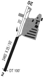
| Runways: | 02/20 |
| Longest Runway: | 02/20 is 2465 ft (751 m) long |
| Runways with an Instrument Approach: |
7S3 Airport Runway Details
| Runway 02/20 | 2465 ft x 48 ft (751 m x 15 m) | |
| Surface: | Asphalt - Good condition - No special surface treatment | |
| Runway Edge Lights: | Low Intensity | |
Runway 02 |
Runway 20 |
|
Glide Path Angle: |
0.0 degrees | 0.0 degrees |
Traffic Pattern: |
Left | Left |
Runway Markings Type: |
Nonstandard (other than numbers only) | Nonstandard (other than numbers only) |
Runway Markings Condition: |
Good | Good |
Object at End: |
TREES | |
Object Height: |
15 | |
Distance from End: |
210 | |
Object Centerline Offset: |
30 ft. right of centerline | |
Displaced Threshold: |
100 |
Services
Airframe Repair: |
Major |
Powerplant Repair: |
Major |
Bottled Oxygen: |
None |
Bulk Oxygen: |
None |
Fuel Available: |
100LL, MOGAS |
Landing Fees: |
No |
Parking: |
Tiedowns available |
Maps & Diagrams
7S3 Sectional
Flight Planning
at skyvector.com
at skyvector.com