Location
Latitude: |
40-35-15.2660N (40.587574) |
Longitude: |
075-01-09.9140W (-75.019421) |
Elevation: |
480.0 feet MSL (146 m MSL) |
Magnetic Variation: |
12.1 W (as of April 2024 from WMM2020 model) |
Time Zone: |
UTC -5.0 (Standard Time) UTC -4.0 (Daylight Savings Time) |
From City: |
02 N.M. W of Pittstown, New Jersey |
Found On: |
New York Chart |
FAA Region: |
AEA |
Contacts
Manager: |
Privately owned: |
| TOM HEIMGARTNER 15 AIRPORT ROAD PITTSTOWN, NJ 08867 908-399-1820 |
ALEXANDRIA FIELD OF NEW JERSEY, LLC 15 AIRPORT ROAD PITTSTOWN, NJ 08867 908-399-1820 |
Operations
Airport Status: |
Operational |
Facility Use: |
Public |
Type: |
Airport |
Activation Date: |
09/1945 |
Control tower: |
No |
Attendance (Months/Days/Hours): |
Months/Days/Hours ALL/ALL/0800-DUSK |
Boundary ARTCC: |
ZNY (New York) |
Responsible ARTCC: |
ZNY (New York) |
Lighting Schedule: |
SEE RMK |
Segmented Circle Indicator: |
No |
Traffic Pattern Altitude (MSL): |
1480 feet (451 m) |
NOTAMs Facility: |
MIV |
NOTAM-D Service: |
Yes |
Based Aircraft
| Single Engine: | 73 |
| Multi Engine: | 2 |
| GA Helicopters: | 1 |
| Ultralights: | 2 |
Annual Operations (as of 03/02/2021)
| Total Operations: | 18367 | |
| GA Local: | 11072 | 60.3% |
| GA Itinerant: | 7295 | 39.7% |
Communications
| CTAF: | 122.975 |
| Unicom: | 122.975 |
| Approach: | ALLENTOWN 119.65 ;3000 FT & BLW 119.65 ;3000 FT & BLW 119.65 ;3000 FT & BLW |
| Departure: | ALLENTOWN 119.65 ;3000 FT & BLW 119.65 ;3000 FT & BLW 119.65 ;3000 FT & BLW |
Fixed Based Operators (FBOs) & Fuel
(Click on a business for detail)
Please help us keep this information up to date. This is a FREE SERVICE just like everything else on Airport Guide! If you see that a business needs to be added, modified, or deleted please fill out our Update Form.
To add, modify, or delete a business click here.
Please help us keep this information up to date. This is a FREE SERVICE just like everything else on Airport Guide! If you see that a business needs to be added, modified, or deleted please fill out our Update Form.
Area Code: 908 |
| Business Name | Frequency | Phone | Fuel Grade |
|---|---|---|---|
| Alexandria Field, Inc.
Update FBO info |
730-9223 | 80, 100LL | |
| State Line Aviation
Update FBO info |
735-4969 |
Flight Service Stations
| Primary | Alternate | |
| FSS on Field: | N | |
| FSS Name (ID): | Millville(MIV) | |
| Frequency: | ||
| Toll Free Phone: | 1-800-WX-BRIEF |
Instrument Procedures / Charts
FAA Terminal Procedures valid from 0901Z 03/21/24 to 0901Z 04/18/24.
There are various types of charts available for an airport. They are listed in the Page Type column. Here is a legend for those types:
APD - Airport Diagram
DP - Departure Procedure Charts
HOT - Hot Spots
IAP - Instrument Approach Procedure Charts
MIN - Minimums
STAR - Standard Terminal Arrival Charts
| Page Type | Page Name | Volume | Action Since Last Cycle |
|---|---|---|---|
| IAP | RNAV (GPS)-A | NE-2 | |
| IAP | RNAV (GPS)-B | NE-2 | |
| IAP | VOR/DME RWY 08 | NE-2 | |
| MIN | TAKEOFF MINIMUMS | NE-2 |
Terminal Procedures are only available for airports in several countries with more being added all the time. If you are looking for a specific country's charts, please send an email to support(at)airportguide.com stating the country name. This will be used to prioritize the implementation.
Navigation Aids (Navaids) near N85
| Dist (NM) | ID | Morse Code | Name | Type | Freq | True Hdg | Mag Hdg |
|---|---|---|---|---|---|---|---|
| 12.7 | SBJ | . . . _ . . . . _ _ _ | Solberg | VOR-DME | 112.90 | 91 | 103 |
| 15.5 | BWZ | _ . . . . _ _ _ _ . . | Broadway | VOR-DME | 114.20 | 35 | 47 |
| 16.0 | UKT | . . _ _ . _ _ | Quakertown | NDB | 208 | 232 | 244 |
| 20.7 | ARD | . _ . _ . _ . . | Yardley | VOR-DME | 108.20 | 165 | 177 |
| 21.5 | FJC | . . _ . . _ _ _ _ . _ . | Allentown | VORTAC | 117.50 | 292 | 304 |
| 25.4 | STW | . . . _ . _ _ | Stillwater | VOR-DME | 109.60 | 15 | 27 |
| 28.4 | CAT | _ . _ . . _ _ | Chatham | NDB | 254 | 70 | 82 |
| 30.2 | ING | . . _ . _ _ . | Ambler | NDB | 275 | 203 | 215 |
| 30.3 | ETX | . _ _ . . _ | East Texas | VOR-DME | 110.20 | 269 | 281 |
| 30.3 | PNE | . _ _ . _ . . | North Philadelphia | VOR | 112.00 | 179 | 191 |
| 33.0 | PTW | . _ _ . _ . _ _ | Pottstown | VORTAC | 116.50 | 228 | 240 |
| 33.3 | RBV | . _ . _ . . . . . . _ | Robbinsville | VORTAC | 113.80 | 133 | 145 |
| 36.1 | SAX | . . . . _ _ . . _ | Sparta | VORTAC | 115.70 | 37 | 49 |
| 38.5 | EWR | . . _ _ . _ . | Maryann | FAN MARKER | 79 | 91 | |
| 38.7 | EWR | . . _ _ . _ . | Newark | DME | 113.75 | 81 | 93 |
| 39.7 | GXU | _ _ . _ . . _ . . _ | Mc Guire | VORTAC | 110.60 | 150 | 162 |
| 42.4 | TE | _ . | Torby | NDB | 214 | 71 | 83 |
| 42.6 | COL | _ . _ . _ _ _ . _ . . | Colts Neck | VOR-DME | 115.40 | 112 | 124 |
| 44.4 | PHL | . _ _ . . . . . . _ . . | Philadelphia | VOT | 109.80 | 192 | 204 |
| 45.0 | NEL | _ . . . _ . . | Lakehurst | TACAN | 111.80 | 137 | 149 |
Nearby Airports with Fuel
Notices to Airmen (NOTAMS)
Remarks
| A110*G | THIS AIRPORT HAS BEEN SURVEYED BY THE NATIONAL GEODETIC SURVEY. |
| A110-1 | TAXI ON PAVEMENT ONLY. |
| A110-2 | HEL TKOF AND LDGS RSTRD TO RWY 08/26 ONLY. |
| A110-3 | HEL USE FIXED-WING TFC PAT AND ALTS. |
| A110-5 | CTC ARPT MGR 908-730-9223 PRIOR TO CONDUCTING HEL TRNG ACT. |
| A110-6 | NO TGL OR STA ALLOWED. |
| A110-7 | FOR CD CTC ALLENTOWN APCH AT 800-728-6322. |
| A33-13/31 | 25 FT WIDE ASPH STRIP FULL LENGTH DOWN CENTER OF RWY. TURF PORTION OF RWY UNUSABLE. |
| A43-26 | PAPI UNUSBL BYD 2 DEGS LEFT OF CNTRLN. |
| A58-26 | +33 FT TREE, 58 FT FM RWY END, 108 FT L. |
| A58-31 | +47 FT TREE, 112 FT FM RWY END, 117 FT L. |
| A70-FUEL-10 | 0LL 24 HR SELF-SERVICE |
| A76 | PARACHUTE JUMPING MAR-NOV. PARACHUTE DROP ZONE ON NORTH SIDE OF ARPT. |
| A81-APT | ACTVT MIRL RY 08/26 - 121.8. |
| A81-BCN | ACTIVATE ROTG BCN - 121.8. |
| E111 | EXISTED PRIOR TO 1959. |
Runways
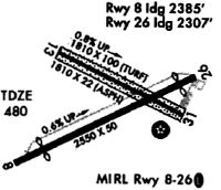
Runway Summary
| Runways: | 08/26 13/31 |
| Longest Runway: | 08/26 is 2550 ft (777 m) long |
| Runways with an Instrument Approach: |
N85 Airport Runway Details
| Runway 08/26 | 2550 ft x 60 ft (777 m x 18 m) | |
| Surface: | Asphalt - Good condition - No special surface treatment | |
| Runway Edge Lights: | Medium Intensity | |
Runway 08 |
Runway 26 |
|
Elevation: |
463.0 | 480.0 |
Latitude: |
40-35-08.5130N | 40-35-19.3720N |
Longitude: |
075-01-24.4380W | 075-00-54.6150W |
|
Runway True Alignment: |
064 | 244 |
Glide Path Angle: |
4.0 degrees | 3.8 degrees |
Traffic Pattern: |
Left | Left |
Runway Markings Type: |
Nonprecision Instrument | Nonprecision Instrument |
Runway Markings Condition: |
Good | Good |
Object at End: |
TREE | TREE |
Object Height: |
50 | 71 |
Distance from End: |
481 | 232 |
Object Centerline Offset: |
102 ft. left of centerline | 208 ft. left of centerline |
Visual Glide Slope Indicators: |
2-Light PAPI On Right Side Of Runway | 2-Light PAPI On Left Side Of Runway |
Threshold Crossing Height: |
30 | 28 |
| Runway 13/31 | 1804 ft x 100 ft (550 m x 30 m) | |
| Runway Length Source: | FAA-EST as of 09/25/2006 | |
| Surface: | Asphalt - Good condition - No special surface treatment | |
Runway 13 |
Runway 31 |
|
Elevation: |
444.0 | 458.7 |
Latitude: |
40-35-21.1580N | 40-35-12.9250N |
Longitude: |
075-01-20.7020W | 075-00-59.9670W |
|
Runway True Alignment: |
118 | 298 |
Glide Path Angle: |
0.0 degrees | 0.0 degrees |
Traffic Pattern: |
Left | Left |
Runway Markings Type: |
Numbers Only | Numbers Only |
Runway Markings Condition: |
Fair | Fair |
Object at End: |
TREE | TREE |
Object Height: |
16 | 64 |
Distance from End: |
433 | 666 |
Object Centerline Offset: |
102 ft. left of centerline | 208 ft. left of centerline |
Services
Airframe Repair: |
Minor |
Powerplant Repair: |
Minor |
Fuel Available: |
100LL |
Landing Fees: |
No |
Parking: |
Hangars and tiedowns available |
Maps & Diagrams
N85 Sectional
Flight Planning
at skyvector.com
at skyvector.com