Location
Latitude: |
27-53-35.5590N (27.893211) |
Longitude: |
081-37-17.2520W (-81.621459) |
Elevation: |
126.7 feet MSL (39 m MSL) |
Magnetic Variation: |
6.6 W (as of April 2024 from WMM2020 model) |
Time Zone: |
UTC -5.0 (Standard Time) UTC -4.0 (Daylight Savings Time) |
From City: |
02 N.M. W of Lake Wales, Florida |
Found On: |
Miami Chart |
FAA Region: |
ASO |
Contacts
Manager: |
Publicly owned: |
| AMANDA KIRBY 450 SOUTH AIRPORT ROAD LAKE WALES, FL 33859-1320 (863) 678-0080 |
LAKE WALES AIRPORT AUTHORITY CITY ADMINISTRATION BUILDING, 201 CENTRAL AVENUE WEST LAKE WALES, FL 33853-1320 863-678-4182 |
Operations
Airport Status: |
Operational |
Facility Use: |
Public |
Type: |
Airport |
Activation Date: |
04/1940 |
Control tower: |
No |
Attendance (Months/Days/Hours): |
Months/Days/Hours ALL/ALL/0800-1700 |
Boundary ARTCC: |
ZMA (Miami) |
Responsible ARTCC: |
ZMA (Miami) |
Lighting Schedule: |
SEE RMK |
Segmented Circle Indicator: |
Yes, Lighted |
Traffic Pattern Altitude (MSL): |
1127 feet (344 m) |
NOTAMs Facility: |
PIE |
NOTAM-D Service: |
Yes |
International Airport of Entry: |
No |
Customs Landing Rights: |
No |
Military Landing Rights: |
Yes |
Civil/Military Joint Use: |
No |
Based Aircraft
| Single Engine: | 24 |
| Multi Engine: | 1 |
| GA Helicopters: | 3 |
| Gliders: | 1 |
| Ultralights: | 2 |
Annual Operations (as of 07/25/2018)
| Total Operations: | 20000 | |
| Air Taxi: | 800 | 4.0% |
| GA Local: | 13986 | 69.9% |
| GA Itinerant: | 5094 | 25.5% |
| Military Aircraft: | 120 | 0.6% |
Communications
| CTAF: | 122.800 |
| Unicom: | 122.800 |
| AWOS-3: | 124.225 (863-678-1334) |
- APCH/DEP SVC PRVDD BY MIAMI ARTCC ON FREQS 134.55/257.7 (AVON PARK RCAG).
Fixed Based Operators (FBOs) & Fuel
(Click on a business for detail)
Please help us keep this information up to date. This is a FREE SERVICE just like everything else on Airport Guide! If you see that a business needs to be added, modified, or deleted please fill out our Update Form.
To add, modify, or delete a business click here.
Please help us keep this information up to date. This is a FREE SERVICE just like everything else on Airport Guide! If you see that a business needs to be added, modified, or deleted please fill out our Update Form.
Area Code: 941 |
| Business Name | Frequency | Phone | Fuel Grade |
|---|---|---|---|
| Lake Wales Aviation
Update FBO info |
Unicom 122.8 | 678-0080 | 100LL, Jet A |
Flight Service Stations
| Primary | Alternate | |
| FSS on Field: | N | |
| FSS Name (ID): | Saint Petersburg(PIE) | |
| Frequency: | ||
| Toll Free Phone: | 1-800-WX-BRIEF |
Instrument Procedures / Charts
FAA Terminal Procedures valid from 0901Z 03/21/24 to 0901Z 04/18/24.
There are various types of charts available for an airport. They are listed in the Page Type column. Here is a legend for those types:
APD - Airport Diagram
DP - Departure Procedure Charts
HOT - Hot Spots
IAP - Instrument Approach Procedure Charts
MIN - Minimums
STAR - Standard Terminal Arrival Charts
| Page Type | Page Name | Volume | Action Since Last Cycle |
|---|---|---|---|
| IAP | RNAV (GPS) RWY 06 | SE-3 | |
| IAP | RNAV (GPS) RWY 24 | SE-3 | |
| IAP | VOR/DME-B | SE-3 | |
| MIN | ALTERNATE MINIMUMS | SE-3 | |
| MIN | TAKEOFF MINIMUMS | SE-3 |
Terminal Procedures are only available for airports in several countries with more being added all the time. If you are looking for a specific country's charts, please send an email to support(at)airportguide.com stating the country name. This will be used to prioritize the implementation.
Navigation Aids (Navaids) near X07
| Dist (NM) | ID | Morse Code | Name | Type | Freq | True Hdg | Mag Hdg |
|---|---|---|---|---|---|---|---|
| 21.5 | LAL | . _ . . . _ . _ . . | Lakeland | VORTAC | 116.00 | 285 | 292 |
| 34.7 | RHZ | . _ . . . . . _ _ . . | Zephyrhills | NDB | 253 | 305 | 311 |
| 38.1 | OR | _ _ _ . _ . | Herny | NDB | 221 | 15 | 22 |
| 41.8 | ORL | _ _ _ . _ . . _ . . | Orlando | VORTAC | 112.20 | 21 | 28 |
| 47.4 | MCF | _ _ _ . _ . . . _ . | Macdill | TACAN | 111.00 | 267 | 273 |
| 48.5 | TPA | _ . _ _ . . _ | Tampa Intl | VOT | 111.00 | 275 | 281 |
| 49.1 | AM | . _ _ _ | Picny | NDB | 388 | 267 | 273 |
| 49.3 | TP | _ . _ _ . | Cosme | NDB | 368 | 283 | 289 |
| 50.3 | SQT | . . . _ _ . _ _ | Satellite | NDB | 257 | 75 | 82 |
| 53.8 | MLB | _ _ . _ . . _ . . . | Melbourne | VOR-DME | 115.85 | 76 | 83 |
| 56.4 | LEE | . _ . . . . | Leesburg | NDB | 335 | 350 | 357 |
| 56.4 | PIE | . _ _ . . . . | St Petersburg | VORTAC | 116.40 | 271 | 277 |
| 57.1 | SFB | . . . . . _ . _ . . . | Sanford | NDB | 408 | 20 | 27 |
| 57.3 | COF | _ . _ . _ _ _ . . _ . | Patrick | TACAN | 115.00 | 68 | 75 |
| 57.4 | TVV | _ . . . _ . . . _ | Space Center Executive | NDB | 237 | 49 | 56 |
| 57.7 | PI | . _ _ . . . | Capok | NDB | 360 | 276 | 282 |
| 58.0 | SRQ | . . . . _ . _ _ . _ | Sarasota | VOR-DME | 117.00 | 239 | 245 |
| 61.4 | TRV | _ . _ . . . . _ | Treasure | VORTAC | 117.30 | 101 | 108 |
| 61.8 | PGD | . _ _ . _ _ . _ . . | Punta Gorda | VOR | 110.20 | 198 | 204 |
| 65.1 | LBV | . _ . . _ . . . . . . _ | La Belle | VORTAC | 110.40 | 169 | 176 |
Nearby Airports with Fuel
Notices to Airmen (NOTAMS)
Remarks
| A11 | CONTACT PERSON: KENNETH FIELDS |
| A110-2 | ULTRALIGHT ACTIVITY ON & INVOF ARPT. |
| A110-4 | TREES IN TRANSITIONAL SFC RY 17; APCH WEST OF RY. |
| A110-5 | RY 17 4 FT FENCE 205 FT FM RY END AT RY HEIGHT. |
| A110-7 | FOR CD CTC MIAMI ARTCC AT 305-716-1731. |
| A70-FUEL-10 | 0LL FUEL AVBL 24 HR CREDIT CARD SVC. |
| A81-APT | ACTVT REIL RWY 6 & 24; PAPI RWY 17 & 35; MIRL RWY 6/ 24 - CTAF. PAPI 6 & 24 OPR CONSLY. |
| E111 | EXISTED PRIOR TO 1959. |
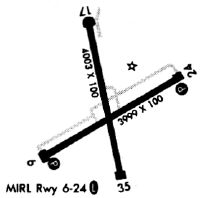
Runways
Runway Summary
| Runways: | 06/24 17/35 |
| Longest Runway: | 06/24 is 5400 ft (1646 m) long |
| Runways with an Instrument Approach: |
X07 Airport Runway Details
| Runway 06/24 | 5400 ft x 100 ft (1646 m x 30 m) | |
| Runway Length Source: | 3RD PARTY SURVEY as of 11/28/2018 | |
| Surface: | Asphalt - Excellent condition - Saw-cut or plastic grooved | |
| Runway Pavement Class: | 6 /F/B/Y/T | |
| Runway Edge Lights: | Medium Intensity | |
Runway Weight Bearing Capacity (in thousands of pounds) |
||
| Single Wheel Landing Gear: | 15.0 | |
Runway 06 |
Runway 24 |
|
Elevation: |
123.4 | 121.4 |
Latitude: |
27-53-18.5092N | 27-53-45.6525N |
Longitude: |
081-37-45.1154W | 081-36-53.2732W |
|
Runway True Alignment: |
059 | 239 |
Glide Path Angle: |
3.5 degrees | 3.5 degrees |
Traffic Pattern: |
Left | Left |
Runway Markings Type: |
Nonprecision Instrument | Nonprecision Instrument |
Runway Markings Condition: |
Good | Good |
Object at End: |
TREES | TREES |
Object Height: |
36 | 51 |
Distance from End: |
1305 | 1770 |
Object Centerline Offset: |
300 ft. left of centerline | 165 ft. right of centerline |
Visual Glide Slope Indicators: |
4-Light PAPI On Left Side Of Runway | 4-Light PAPI On Left Side Of Runway |
REIL: |
Yes | Yes |
Threshold Crossing Height: |
44 | 44 |
| Runway 17/35 | 3860 ft x 75 ft (1177 m x 23 m) | |
| Runway Length Source: | 3RD PARTY SURVEY as of 11/28/2018 | |
| Surface: | Asphalt - Excellent condition - No special surface treatment | |
| Runway Pavement Class: | 8 /F/B/Y/T | |
Runway Weight Bearing Capacity (in thousands of pounds) |
||
| Single Wheel Landing Gear: | 15.0 | |
Runway 17 |
Runway 35 |
|
Elevation: |
123.6 | 122.3 |
Latitude: |
27-53-59.0787N | 27-53-21.7689N |
Longitude: |
081-37-19.1914W | 081-37-09.8773W |
|
Runway True Alignment: |
167 | 347 |
Glide Path Angle: |
3.4 degrees | 3.0 degrees |
Traffic Pattern: |
Left | Left |
Runway Markings Type: |
Basic | Basic |
Runway Markings Condition: |
Fair | Fair |
Object at End: |
TREE | BRUSH |
Object Height: |
38 | 3 |
Distance from End: |
415 | 280 |
Object Centerline Offset: |
300 ft. left of centerline | 165 ft. right of centerline |
Visual Glide Slope Indicators: |
2-Light PAPI On Right Side Of Runway | 2-Light PAPI On Left Side Of Runway |
Threshold Crossing Height: |
45 | 32 |
Services
Airframe Repair: |
Minor |
Powerplant Repair: |
Minor |
Fuel Available: |
100LL |
Landing Fees: |
No |
Parking: |
Hangars and tiedowns available |
Maps & Diagrams
X07 Sectional
Flight Planning
at skyvector.com
at skyvector.com