Location
Latitude: |
40-31-12.3000N (40.520083) |
Longitude: |
090-39-08.6000W (-90.652389) |
Elevation: |
705.7 feet MSL (215 m MSL) |
Magnetic Variation: |
1.7 W (as of April 2024 from WMM2020 model) |
Time Zone: |
UTC -6.0 (Standard Time) UTC -5.0 (Daylight Savings Time) |
From City: |
03 N.M. N of Macomb, Illinois |
Found On: |
Chicago Chart |
FAA Region: |
AGL |
Contacts
Manager: |
Publicly owned: |
| LEE COBB 16190 E 1300TH ST MACOMB, IL 61455 309-833-3324 |
MACOMB ARPT AUTHORITY 16190 E 1300TH ST MACOMB, IL 61455 309-833-3324 |
Operations
Airport Status: |
Operational |
Facility Use: |
Public |
Type: |
Airport |
Control tower: |
No |
Attendance (Months/Days/Hours): |
Months/Days/Hours ALL/SAT-SUN/0800-1200 |
Boundary ARTCC: |
ZAU (Chicago) |
Responsible ARTCC: |
ZAU (Chicago) |
Lighting Schedule: |
SEE RMK |
Segmented Circle Indicator: |
No |
Traffic Pattern Altitude (MSL): |
1706 feet (520 m) |
NOTAMs Facility: |
MQB |
NOTAM-D Service: |
Yes |
International Airport of Entry: |
No |
Customs Landing Rights: |
No |
Military Landing Rights: |
Yes |
Civil/Military Joint Use: |
No |
Based Aircraft
| Single Engine: | 19 |
| Multi Engine: | 2 |
Annual Operations (as of 05/31/2021)
| Total Operations: | 9000 | |
| Air Taxi: | 2500 | 27.8% |
| GA Local: | 3000 | 33.3% |
| GA Itinerant: | 3500 | 38.9% |
Communications
| CTAF: | 122.800 |
| Unicom: | 122.800 |
| AWOS-3: | 119.025 (309-837-4022) |
- APCH/DEP SVC PRVDD BY CHICAGO ARTCC ON FREQS 135.6/316.1 (BURLINGTON RCAG).
Fixed Based Operators (FBOs) & Fuel
(Click on a business for detail)
Please help us keep this information up to date. This is a FREE SERVICE just like everything else on Airport Guide! If you see that a business needs to be added, modified, or deleted please fill out our Update Form.
To add, modify, or delete a business click here.
Please help us keep this information up to date. This is a FREE SERVICE just like everything else on Airport Guide! If you see that a business needs to be added, modified, or deleted please fill out our Update Form.
Area Code: 309 |
| Business Name | Frequency | Phone | Fuel Grade |
|---|---|---|---|
| Cobb Aviation Services
Update FBO info |
Unicom 122.8 | 833-3324 | 100LL, Jet A |
Flight Service Stations
| Primary | Alternate | |
| FSS on Field: | N | |
| FSS Name (ID): | Kankakee(IKK) | |
| Frequency: | ||
| Toll Free Phone: | 1-800-WX-BRIEF |
Instrument Procedures / Charts
FAA Terminal Procedures valid from 0901Z 03/21/24 to 0901Z 04/18/24.
There are various types of charts available for an airport. They are listed in the Page Type column. Here is a legend for those types:
APD - Airport Diagram
DP - Departure Procedure Charts
HOT - Hot Spots
IAP - Instrument Approach Procedure Charts
MIN - Minimums
STAR - Standard Terminal Arrival Charts
| Page Type | Page Name | Volume | Action Since Last Cycle |
|---|---|---|---|
| IAP | LOC RWY 27 | EC-3 | |
| IAP | RNAV (GPS) RWY 09 | EC-3 | |
| IAP | RNAV (GPS) RWY 27 | EC-3 | |
| MIN | ALTERNATE MINIMUMS | EC-3 | |
| MIN | TAKEOFF MINIMUMS | EC-3 |
Terminal Procedures are only available for airports in several countries with more being added all the time. If you are looking for a specific country's charts, please send an email to support(at)airportguide.com stating the country name. This will be used to prioritize the implementation.
Navigation Aids (Navaids) near MQB
| Dist (NM) | ID | Morse Code | Name | Type | Freq | True Hdg | Mag Hdg |
|---|---|---|---|---|---|---|---|
| 4.2 | JZY | . _ _ _ _ _ . . _ . _ _ | Macomb | NDB | 251 | 91 | 93 |
| 17.4 | BRL | _ . . . . _ . . _ . . | Burlington | VOR-DME | 111.40 | 314 | 316 |
| 22.9 | BR | _ . . . . _ . | Burns | NDB | 390 | 290 | 292 |
| 26.4 | CTK | _ . _ . _ _ . _ | Canton | NDB | 236 | 83 | 85 |
| 26.9 | GBG | _ _ . _ . . . _ _ . | Galesburg | DME | 109.8 | 21 | 23 |
| 35.8 | EOK | . _ _ _ _ . _ | Keokuk | NDB | 366 | 264 | 265 |
| 40.3 | PIA | . _ _ . . . . _ | Peoria | VORTAC | 115.20 | 75 | 77 |
| 46.9 | MPZ | _ _ . _ _ . _ _ . . | Mount Pleasant | NDB | 212 | 303 | 304 |
| 46.9 | UI | . . _ . . | Quincy | NDB | 293 | 216 | 218 |
| 48.1 | MZV | _ _ _ _ . . . . . _ | Moline | VOR-DME | 114.40 | 0 | 2 |
| 48.5 | IJX | . . . _ _ _ _ . . _ | Jacksonville | DME | 108.6 | 156 | 158 |
| 48.6 | PI | . _ _ . . . | Tungg | NDB | 356 | 83 | 85 |
| 49.5 | UIN | . . _ . . _ . | Quincy | TACAN | 113.60 | 215 | 216 |
| 55.5 | DDD | _ . . _ . . _ . . | Port City | DME | 116.5 | 336 | 338 |
| 60.4 | LQ | . _ . . _ _ . _ | Licol | NDB | 375 | 126 | 128 |
| 60.5 | SPI | . . . . _ _ . . . | Spinner | VORTAC | 112.70 | 132 | 134 |
| 60.7 | SP | . . . . _ _ . | Huskk | NDB | 382 | 137 | 139 |
| 61.7 | BDF | _ . . . _ . . . . _ . | Bradford | VORTAC | 114.70 | 51 | 53 |
| 63.9 | AAA | . _ . _ . _ | Abraham | NDB | 329 | 109 | 111 |
| 65.0 | AWG | . _ . _ _ _ _ . | Washington | NDB | 219 | 314 | 315 |
Nearby Airports with Fuel
Notices to Airmen (NOTAMS)
Remarks
| A110-1 | FOR CD IF UNA TO CTC ON FSS FREQ, CTC CHICAGO ARTCC AT 630-906-8921. |
| A30-18/36 | RY 18/36 SEASONAL, NOV 1 - MAY 1 CTC AMGR 309-833-3324. |
| A32-18/36 | TURF WIDTH 200 FT SOUTH OF INTERSECTION WITH RY 09/27. |
| A43-09 | PAPI UNUSBL BYD 8 DEGS RIGHT OF CNTRLN. |
| A81-APT | HIRL RY 09/27 PRESET ON LOW INTST; TO INCR INTST & ACTVT REIL RY 09 & 27, AND TWY LGTS - CTAF. |
Runways
Runway Summary
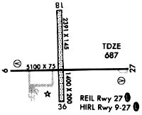
| Runways: | 09/27 18/36 |
| Longest Runway: | 09/27 is 5100 ft (1554 m) long |
| Runways with an Instrument Approach: | 27 |
MQB Seaplane Base Runway Details
| Runway 09/27 | 5100 ft x 100 ft (1554 m x 30 m) | |
| Runway Length Source: | 3RD PARTY SURVEY as of 09/22/2009 | |
| Surface: | Asphalt - Fair condition - No special surface treatment | |
| Runway Edge Lights: | High Intensity | |
Runway Weight Bearing Capacity (in thousands of pounds) |
||
| Single Wheel Landing Gear: | 18.0 | |
| Dual Wheel Landing Gear: | 21.0 | |
Runway 09 |
Runway 27 |
|
Elevation: |
705.7 | 679.4 |
Latitude: |
40-31-10.9130N | 40-31-10.8362N |
Longitude: |
090-39-39.7646W | 090-38-33.7344W |
|
Runway True Alignment: |
090 | 270 |
ILS Type: |
LOCALIZER | |
Glide Path Angle: |
3.0 degrees | 3.0 degrees |
Traffic Pattern: |
Left | Left |
Runway Markings Type: |
Nonprecision Instrument | Nonprecision Instrument |
Runway Markings Condition: |
Good | Good |
Visual Glide Slope Indicators: |
4-Light PAPI On Left Side Of Runway | 4-Light PAPI On Left Side Of Runway |
REIL: |
Yes | Yes |
Touchdown Lights: |
No | No |
Centerline Lights: |
No | No |
Threshold Crossing Height: |
43 | 40 |
| Runway 18/36 | 3719 ft x 190 ft (1134 m x 58 m) | |
| Runway Length Source: | 3RD PARTY SURVEY as of 09/22/2009 | |
| Surface: | Asphalt - Fair condition - No special surface treatment | |
Runway 18 |
Runway 36 |
|
Elevation: |
691.3 | 681.6 |
Latitude: |
40-31-32.5381N | 40-30-55.7865N |
Longitude: |
090-39-11.1980W | 090-39-11.2700W |
|
Runway True Alignment: |
180 | 000 |
Glide Path Angle: |
0.0 degrees | 0.0 degrees |
Traffic Pattern: |
Left | Left |
REIL: |
No | No |
Touchdown Lights: |
No | No |
Centerline Lights: |
No | No |
Services
Airframe Repair: |
Minor |
Powerplant Repair: |
Minor |
Bottled Oxygen: |
None |
Bulk Oxygen: |
None |
Fuel Available: |
100LL |
Landing Fees: |
No |
Parking: |
Tiedowns available |
Maps & Diagrams
MQB Sectional
Flight Planning
at skyvector.com
at skyvector.com