Location
Latitude: |
30-52-13.2000N (30.870333) |
Longitude: |
087-49-09.6000W (-87.819333) |
Elevation: |
248.1 feet MSL (76 m MSL) |
Magnetic Variation: |
3 W (as of April 2024 from WMM2020 model) |
Time Zone: |
UTC -6.0 (Standard Time) UTC -5.0 (Daylight Savings Time) |
From City: |
03 N.M. SW of Bay Minette, Alabama |
Found On: |
New Orleans Chart |
FAA Region: |
ASO |
Contacts
Manager: |
Publicly owned: |
| ASHLEY BOOTHE 11981 AIRPORT RD BAY MINETTE, AL 36507 251-937-2900 |
CITY OF BAY MINETTE PO BOX 1208 BAY MINETTE, AL 36507 251-580-1619 |
Operations
Airport Status: |
Operational |
Facility Use: |
Public |
Type: |
Airport |
Activation Date: |
10/1962 |
Control tower: |
No |
Attendance (Months/Days/Hours): |
Months/Days/Hours ALL/ALL/0800-1700 |
Boundary ARTCC: |
ZHU (Houston) |
Responsible ARTCC: |
ZHU (Houston) |
Lighting Schedule: |
SEE RMK |
Segmented Circle Indicator: |
Yes |
Traffic Pattern Altitude (MSL): |
1248 feet (380 m) |
NOTAMs Facility: |
ANB |
NOTAM-D Service: |
Yes |
International Airport of Entry: |
No |
Customs Landing Rights: |
No |
Military Landing Rights: |
Yes |
Civil/Military Joint Use: |
No |
Based Aircraft
| Single Engine: | 12 |
Annual Operations (as of 12/31/2018)
| Total Operations: | 175200 | |
| Air Taxi: | 8760 | 5.0% |
| GA Local: | 101616 | 58.0% |
| GA Itinerant: | 38544 | 22.0% |
| Military Aircraft: | 26280 | 15.0% |
Communications
| CTAF: | 122.800 |
| Unicom: | 122.800 |
| Approach: | MOBILE 118.5 118.5 HOUSTON ARTCC |
| Departure: | MOBILE 118.5 118.5 HOUSTON ARTCC |
| AWOS-3PT: | 121.125 (251-580-5103) |
- APCH/DEP SVC PRVDD BY HOUSTON ARTCC (ZHU) ON FREQS 127.65/285.475 (MOBILE RCAG) WHEN MOBILE APCH CTL (MOB) CLSD.
Fixed Based Operators (FBOs) & Fuel
(Click on a business for detail)
Please help us keep this information up to date. This is a FREE SERVICE just like everything else on Airport Guide! If you see that a business needs to be added, modified, or deleted please fill out our Update Form.
To add, modify, or delete a business click here.
Please help us keep this information up to date. This is a FREE SERVICE just like everything else on Airport Guide! If you see that a business needs to be added, modified, or deleted please fill out our Update Form.
Area Code: 334 |
| Business Name | Frequency | Phone | Fuel Grade |
|---|---|---|---|
| Clark Aviation
Update FBO info |
Unicom 122.8 | 937-8227 | 100LL |
Flight Service Stations
| Primary | Alternate | |
| FSS on Field: | N | |
| FSS Name (ID): | Anniston(ANB) | |
| Frequency: | ||
| Toll Free Phone: | 1-800-WX-BRIEF |
Instrument Procedures / Charts
FAA Terminal Procedures valid from 0901Z 03/21/24 to 0901Z 04/18/24.
There are various types of charts available for an airport. They are listed in the Page Type column. Here is a legend for those types:
APD - Airport Diagram
DP - Departure Procedure Charts
HOT - Hot Spots
IAP - Instrument Approach Procedure Charts
MIN - Minimums
STAR - Standard Terminal Arrival Charts
| Page Type | Page Name | Volume | Action Since Last Cycle |
|---|---|---|---|
| IAP | RNAV (GPS) RWY 08 | SE-4 | |
| IAP | RNAV (GPS) RWY 26 | SE-4 | |
| MIN | ALTERNATE MINIMUMS | SE-4 | |
| MIN | TAKEOFF MINIMUMS | SE-4 |
Terminal Procedures are only available for airports in several countries with more being added all the time. If you are looking for a specific country's charts, please send an email to support(at)airportguide.com stating the country name. This will be used to prioritize the implementation.
Navigation Aids (Navaids) near 1R8
| Dist (NM) | ID | Morse Code | Name | Type | Freq | True Hdg | Mag Hdg |
|---|---|---|---|---|---|---|---|
| 19.7 | BFM | _ . . . . . _ . _ _ | Brookley | VORTAC | 116.35 | 218 | 221 |
| 22.8 | ESU | . . . . . . _ | Summerdale | NDB | 204 | 167 | 170 |
| 25.8 | MOB | _ _ _ _ _ _ . . . | Wisle | NDB | 248 | 255 | 258 |
| 29.1 | SJI | . . . . _ _ _ . . | Semmes | VORTAC | 115.30 | 252 | 255 |
| 34.5 | NUN | _ . . . _ _ . | Saufley | VOR | 112.25 | 133 | 136 |
| 36.9 | GCV | _ _ . _ . _ . . . . _ | Greene County | VORTAC | 115.70 | 291 | 294 |
| 40.2 | NPA | _ . . _ _ . . _ | Pensacola | TACAN | 117.20 | 139 | 142 |
| 42.1 | PKZ | . _ _ . _ . _ _ _ . . | Pickens | NDB | 326 | 127 | 130 |
| 42.2 | NSE | _ . . . . . | Whiting | TACAN | 112.30 | 101 | 104 |
| 42.7 | MVC | _ _ . . . _ _ . _ . | Monroeville | VORTAC | 116.80 | 34 | 37 |
| 48.0 | NGS | _ . _ _ . . . . | Santa Rosa | TACAN | 133.60 | 108 | 111 |
| 58.8 | CEW | _ . _ . . . _ _ | Crestview | VORTAC | 115.90 | 92 | 95 |
| 63.7 | BIX | _ . . . . . _ . . _ | Keesler | TACAN | 111.80 | 244 | 247 |
| 64.0 | HRT | . . . . . _ . _ | Hurlburt | TACAN | 110.80 | 114 | 117 |
| 66.1 | CE | _ . _ . . | Kobra | NDB | 201 | 90 | 93 |
| 70.6 | GPT | _ _ . . _ _ . _ | Gulfport | VORTAC | 109.00 | 247 | 250 |
| 71.0 | DWG | _ . . . _ _ _ _ . | Warrington | TACAN | 134.50 | 109 | 112 |
| 73.0 | GP | _ _ . . _ _ . | Bayou | NDB | 360 | 251 | 254 |
| 77.9 | JUY | . _ _ _ . . _ _ . _ _ | Judd | NDB | 264 | 70 | 73 |
| 84.6 | LBY | . _ . . _ . . . _ . _ _ | Eaton | VORTAC | 110.60 | 293 | 296 |
Nearby Airports with Fuel
Notices to Airmen (NOTAMS)
Remarks
| A110-1 | FOR CD CTC MOBILE APCH AT 251-662-6236, WHEN APCH CLSD CTC HOUSTON ARTCC AT 281-230-5622. |
| A42-26 | RWY ID AND TD MRKGS SEVERELY FADED |
| A70-FUEL-10 | 0LL 100LL FUEL 24 HR SELF SVC AVBL. |
| A70-FUEL-A+ | JET A+ FUEL SVC AVBL 0800-1700 CALL 251-937-2900. |
| A81-APT | ACTVT PAPI RWY 08 & 26; MIRL RWY 08/26 - CTAF. |
| E111 | BEFORE FAA ACT. |
Runways
Runway Summary
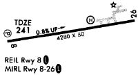
| Runways: | 08/26 |
| Longest Runway: | 08/26 is 5500 ft (1676 m) long |
| Runways with an Instrument Approach: |
1R8 Airport Runway Details
| Runway 08/26 | 5500 ft x 79 ft (1676 m x 24 m) | |
| Runway Length Source: | 3RD PARTY SURVEY as of 11/16/2008 | |
| Surface: | Asphalt - Good condition - Saw-cut or plastic grooved | |
| Runway Edge Lights: | Medium Intensity | |
Runway Weight Bearing Capacity (in thousands of pounds) |
||
| Single Wheel Landing Gear: | 28.0 | |
Runway 08 |
Runway 26 |
|
Elevation: |
206.5 | 248.1 |
Latitude: |
30-52-11.1626N | 30-52-15.1746N |
Longitude: |
087-49-41.0186W | 087-48-38.0898W |
|
Runway True Alignment: |
086 | 266 |
Glide Path Angle: |
3.5 degrees | 3.0 degrees |
Traffic Pattern: |
Left | Left |
Runway Markings Type: |
Nonprecision Instrument | Nonprecision Instrument |
Runway Markings Condition: |
Fair | Poor |
Object at End: |
TREE | BRUSH |
Object Height: |
111 | 14 |
Distance from End: |
2397 | 430 |
Object Centerline Offset: |
4 ft. right of centerline | 75 ft. right of centerline |
Visual Glide Slope Indicators: |
2-Light PAPI On Left Side Of Runway | 2-Light PAPI On Left Side Of Runway |
REIL: |
Yes | |
Threshold Crossing Height: |
47 | 40 |
Services
Airframe Repair: |
Major |
Powerplant Repair: |
Major |
Bottled Oxygen: |
None |
Bulk Oxygen: |
None |
Fuel Available: |
100LL, Jet A+ |
Landing Fees: |
No |
Parking: |
Tiedowns available |
Maps & Diagrams
1R8 Sectional
Flight Planning
at skyvector.com
at skyvector.com