Location
Latitude: |
33-50-48.1880N (33.846719) |
Longitude: |
088-06-55.7130W (-88.115476) |
Elevation: |
463.0 feet MSL (141 m MSL) |
Magnetic Variation: |
3 W (as of April 2024 from WMM2020 model) |
Time Zone: |
UTC -6.0 (Standard Time) UTC -5.0 (Daylight Savings Time) |
From City: |
06 N.M. N of Vernon, Alabama |
Found On: |
Memphis Chart |
FAA Region: |
ASO |
Contacts
Manager: |
Publicly owned: |
| CHRIS WILBANKS PO BOX 338 VERNON, AL 35592 205-695-7136 |
LAMAR COUNTY COMSN PO BOX 338 VERNON, AL 35592 205-695-9119 |
Operations
Airport Status: |
Operational |
Facility Use: |
Public |
Type: |
Airport |
Activation Date: |
08/1965 |
Control tower: |
No |
Attendance (Months/Days/Hours): |
Months/Days/Hours Unattended |
Boundary ARTCC: |
ZME (Memphis) |
Responsible ARTCC: |
ZME (Memphis) |
Lighting Schedule: |
SEE RMK |
Segmented Circle Indicator: |
No |
Traffic Pattern Altitude (MSL): |
1463 feet (446 m) |
NOTAMs Facility: |
ANB |
NOTAM-D Service: |
Yes |
International Airport of Entry: |
No |
Customs Landing Rights: |
No |
Military Landing Rights: |
No |
Civil/Military Joint Use: |
No |
Based Aircraft
Annual Operations (as of 02/01/2019)
| Total Operations: | 1604 | |
| GA Local: | 144 | 9.0% |
| GA Itinerant: | 1460 | 91.0% |
Communications
| CTAF: | 122.900 |
| Approach: | COLUMBUS 126.075 126.075 MEMPHIS ARTCC |
| Departure: | COLUMBUS 126.075 126.075 MEMPHIS ARTCC |
- APCH/DEP SVC PRVDD BY MEMPHIS ARTCC (COLUMBUS RCAG) ON FREQS 127.1/269.4 WHEN COLUMBUS APCH CTL CLSD.
Fixed Based Operators (FBOs) & Fuel
(Click on a business for detail)
Please help us keep this information up to date. This is a FREE SERVICE just like everything else on Airport Guide! If you see that a business needs to be added, modified, or deleted please fill out our Update Form.
To add, modify, or delete a business click here.
Please help us keep this information up to date. This is a FREE SERVICE just like everything else on Airport Guide! If you see that a business needs to be added, modified, or deleted please fill out our Update Form.
Area Code: 205 |
| Business Name | Frequency | Phone | Fuel Grade |
|---|
Flight Service Stations
| Primary | Alternate | |
| FSS on Field: | N | |
| FSS Name (ID): | Anniston(ANB) | |
| Frequency: | ||
| Toll Free Phone: | 1-800-WX-BRIEF |
Instrument Procedures / Charts
FAA Terminal Procedures valid from 0901Z 03/21/24 to 0901Z 04/18/24.
There are various types of charts available for an airport. They are listed in the Page Type column. Here is a legend for those types:
APD - Airport Diagram
DP - Departure Procedure Charts
HOT - Hot Spots
IAP - Instrument Approach Procedure Charts
MIN - Minimums
STAR - Standard Terminal Arrival Charts
| Page Type | Page Name | Volume | Action Since Last Cycle |
|---|---|---|---|
| IAP | RNAV (GPS) RWY 17 | SE-4 | |
| IAP | RNAV (GPS) RWY 35 | SE-4 | |
| MIN | TAKEOFF MINIMUMS | SE-4 |
Terminal Procedures are only available for airports in several countries with more being added all the time. If you are looking for a specific country's charts, please send an email to support(at)airportguide.com stating the country name. This will be used to prioritize the implementation.
Navigation Aids (Navaids) near M55
| Dist (NM) | ID | Morse Code | Name | Type | Freq | True Hdg | Mag Hdg |
|---|---|---|---|---|---|---|---|
| 20.3 | CBM | _ . _ . _ . . . _ _ | Caledonia | VORTAC | 115.20 | 232 | 235 |
| 21.7 | HAB | . . . . . _ _ . . . | Hamilton | DME | 110.4 | 13 | 16 |
| 29.4 | IGB | . . _ _ . _ . . . | Bigbee | VORTAC | 116.20 | 222 | 225 |
| 38.2 | TU | _ . . _ | Veron | NDB | 420 | 301 | 304 |
| 40.8 | OTB | _ _ _ _ _ . . . | Tupelo | VOR-DME | 109.80 | 303 | 306 |
| 45.6 | LDK | . _ . . _ . . _ . _ | Crimson | TACAN | 117.80 | 140 | 143 |
| 46.9 | TC | _ _ . _ . | Tuske | NDB | 362 | 151 | 154 |
| 56.6 | OKW | _ _ _ _ . _ . _ _ | Brookwood | VORTAC | 111.00 | 129 | 132 |
| 60.2 | MSL | _ _ . . . . _ . . | Muscle Shoals | DME | 116.25 | 30 | 33 |
| 61.6 | VUZ | . . . _ . . _ _ _ . . | Vulcan | VORTAC | 114.40 | 99 | 102 |
| 66.5 | BH | _ . . . . . . . | Mcden | NDB | 224 | 107 | 110 |
| 70.0 | BHM | _ . . . . . . . _ _ | Birmingham Muni | VOT | 110.00 | 103 | 106 |
| 74.4 | UU | . . _ . . _ | Seyer | NDB | 334 | 340 | 343 |
| 75.6 | DCU | _ . . _ . _ . . . _ | Decatur | DME | 112.8 | 50 | 53 |
| 79.1 | NMM | _ . _ _ _ _ | Meridian | TACAN | 111.90 | 195 | 198 |
| 81.7 | UV | . . _ . . . _ | Tunng | NDB | 426 | 293 | 296 |
| 81.8 | HSV | . . . . . . . . . . _ | Huntsville | VOT | 111.00 | 54 | 58 |
| 85.7 | SZY | . . . _ _ . . _ . _ _ | Sibley | NDB | 386 | 346 | 349 |
| 86.5 | CWH | _ . _ . . _ _ . . . . | Capshaw | NDB | 350 | 49 | 53 |
| 87.3 | HUA | . . . . . . _ . _ | Redstone | NDB | 287 | 53 | 57 |
Nearby Airports with Fuel
Notices to Airmen (NOTAMS)
Remarks
| A110*G | THIS AIRPORT HAS BEEN SURVEYED BY THE NATIONAL GEODETIC SURVEY. |
| A110-1 | FOR CD CTC MEMPHIS ARTCC AT 901-368-8453/8449. |
| A110-2 | ALL ARPT LGT OTS. |
| A33-17/35 | WDSPRD JOINT CRACKING WITH VEGETATION. |
| A40-17/35 | ARPT LGTS INOP. |
| A42-17 | RWY MARKINGS POOR DUE TO FADING |
| A42-35 | RWY MARKINGS POOR DUE TO FADING |
| A58-17 | 13 FT TREE 160 FT FM RWY END 111 FT RIGHT OF CNTRLN, 0:1 OBST CLNC; 18 FT TREE 149 FT FM RWY END 126 FT RIGHT OF CNTRLN; 11 FT TREE 163 FT FM RWY END 94 FT RIGHT OF CNTRLN; 6 FT TREE 197 FT FM RWY END 96 FT LEFT OF CNTRLN; 2 FT FENCE 196 FT FM RWY END 109 FT LEFT OF CNTRLN. |
| A58-35 | 11 FT TREE 189 FT FM RWY END 71 FT RIGHT OF CNTRLN, 0:1 OBST CLNC; 22 FT TREE 198 FT FM RWY END 125 FT RIGHT OF CNTRLN; 16 FT TREE 191 FT FM RWY END 74 FT LEFT OF CNTRLN. |
| A81-APT | ARPT LGTS INOP. |
| E111 | BEFORE FAA ACT. |
Runways
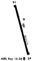
Runway Summary
| Runways: | 17/35 |
| Longest Runway: | 17/35 is 3613 ft (1101 m) long |
| Runways with an Instrument Approach: |
M55 Airport Runway Details
| Runway 17/35 | 3613 ft x 75 ft (1101 m x 23 m) | |
| Surface: | Asphalt - Poor condition - No special surface treatment | |
| Runway Edge Lights: | Medium Intensity | |
Runway Weight Bearing Capacity (in thousands of pounds) |
||
| Single Wheel Landing Gear: | 16.0 | |
Runway 17 |
Runway 35 |
|
Elevation: |
463.0 | 457.0 |
Latitude: |
33-51-05.5050N | 33-50-30.9000N |
Longitude: |
088-07-01.0110W | 088-06-50.4000W |
|
Runway True Alignment: |
166 | 346 |
Glide Path Angle: |
0.0 degrees | 0.0 degrees |
Traffic Pattern: |
Left | Left |
Runway Markings Type: |
Nonprecision Instrument | Nonprecision Instrument |
Runway Markings Condition: |
Poor | Poor |
Object at End: |
TREES | TREES |
Object Height: |
14 | 17 |
Distance from End: |
336 | 202 |
Object Centerline Offset: |
137 ft. left of centerline | 11 ft. left of centerline |
Visual Glide Slope Indicators: |
Pulsating/Steady Burning VASI On Left Side Of Runway | Pulsating/Steady Burning VASI On Left Side Of Runway |
Services
Airframe Repair: |
None |
Powerplant Repair: |
Minor |
Bottled Oxygen: |
None |
Bulk Oxygen: |
None |
Fuel Available: |
100LL |
Landing Fees: |
No |
Maps & Diagrams
M55 Sectional
Flight Planning
at skyvector.com
at skyvector.com