Location
Latitude: |
40-49-16.4450N (40.821235) |
Longitude: |
076-51-51.0200W (-76.864172) |
Elevation: |
463.5 feet MSL (141 m MSL) |
Magnetic Variation: |
11.2 W (as of April 2024 from WMM2020 model) |
Time Zone: |
UTC -5.0 (Standard Time) UTC -4.0 (Daylight Savings Time) |
From City: |
01 N.M. N of Selinsgrove, Pennsylvania |
Found On: |
New York Chart |
FAA Region: |
AEA |
Contacts
Manager: |
Publicly owned: |
| STEPHEN BOWERS 100 AIRPORT RD SELINSGROVE, PA 17870 570-809-4701 |
PENN VALLEY AIRPORT AUTH 100 AIRPORT RD SELINSGROVE, PA 17870 570-374-7671 |
Operations
Airport Status: |
Operational |
Facility Use: |
Public |
Type: |
Airport |
Activation Date: |
05/1945 |
Control tower: |
No |
Attendance (Months/Days/Hours): |
Months/Days/Hours ALL/SAT-SUN/0800-1600 |
Boundary ARTCC: |
ZNY (New York) |
Responsible ARTCC: |
ZNY (New York) |
Lighting Schedule: |
SEE RMK |
Segmented Circle Indicator: |
No |
Traffic Pattern Altitude (MSL): |
1464 feet (446 m) |
NOTAMs Facility: |
SEG |
NOTAM-D Service: |
Yes |
International Airport of Entry: |
No |
Customs Landing Rights: |
No |
Military Landing Rights: |
Yes |
Civil/Military Joint Use: |
No |
Based Aircraft
| Single Engine: | 24 |
| Multi Engine: | 2 |
| Jet Engine: | 2 |
| GA Helicopters: | 2 |
Annual Operations (as of 12/19/2023)
| Total Operations: | 22000 | |
| Air Taxi: | 2800 | 12.7% |
| GA Local: | 13000 | 59.1% |
| GA Itinerant: | 6000 | 27.3% |
| Military Aircraft: | 200 | 0.9% |
Communications
| CTAF: | 122.700 |
| Unicom: | 122.700 |
| Approach: | HARRISBURG 118.25 118.25 |
| Departure: | HARRISBURG 118.25 118.25 |
| ASOS: | 123.975 (570-374-4099) |
Fixed Based Operators (FBOs) & Fuel
(Click on a business for detail)
Please help us keep this information up to date. This is a FREE SERVICE just like everything else on Airport Guide! If you see that a business needs to be added, modified, or deleted please fill out our Update Form.
To add, modify, or delete a business click here.
Please help us keep this information up to date. This is a FREE SERVICE just like everything else on Airport Guide! If you see that a business needs to be added, modified, or deleted please fill out our Update Form.
Area Code: 570 |
| Business Name | Frequency | Phone | Fuel Grade |
|---|---|---|---|
| Heritage Aviation
Website Update FBO info |
122.7 Unicom 123.97 ASOS | (570) 374-7671 | 100LL, Jet A |

|
Phillips | 100LL - 5.99 USD per gallon on 8/2/11 |
Pumps or Trucks |
|
|
Phillips | Jet A - 5.19 USD per gallon on 8/2/11 |
Pumps or Trucks |
| Penn Valley Airport Authority
Update FBO info |
Unicom 122.7 | 374-7671 | 100LL, Jet A |
Flight Service Stations
| Primary | Alternate | |
| FSS on Field: | N | |
| FSS Name (ID): | Williamsport(IPT) | |
| Frequency: | ||
| Toll Free Phone: | 1-800-WX-BRIEF |
Instrument Procedures / Charts
FAA Terminal Procedures valid from 0901Z 03/21/24 to 0901Z 04/18/24.
There are various types of charts available for an airport. They are listed in the Page Type column. Here is a legend for those types:
APD - Airport Diagram
DP - Departure Procedure Charts
HOT - Hot Spots
IAP - Instrument Approach Procedure Charts
MIN - Minimums
STAR - Standard Terminal Arrival Charts
| Page Type | Page Name | Volume | Action Since Last Cycle |
|---|---|---|---|
| IAP | RNAV (GPS) RWY 17 | NE-4 | |
| IAP | RNAV (GPS) RWY 35 | NE-4 | |
| IAP | VOR-A | NE-4 | |
| MIN | ALTERNATE MINIMUMS | NE-4 | |
| MIN | TAKEOFF MINIMUMS | NE-4 |
Terminal Procedures are only available for airports in several countries with more being added all the time. If you are looking for a specific country's charts, please send an email to support(at)airportguide.com stating the country name. This will be used to prioritize the implementation.
Navigation Aids (Navaids) near SEG
| Dist (NM) | ID | Morse Code | Name | Type | Freq | True Hdg | Mag Hdg |
|---|---|---|---|---|---|---|---|
| 2.0 | SEG | . . . . _ _ . | Selinsgrove | VOR-DME | 110.40 | 206 | 217 |
| 15.1 | MIP | _ _ . . . _ _ . | Milton | VORTAC | 109.20 | 36 | 47 |
| 20.1 | RAV | . _ . . _ . . . _ | Ravine | VORTAC | 114.60 | 143 | 154 |
| 27.1 | BZJ | _ . . . _ _ . . . _ _ _ | Bellgrove | NDB | 328 | 148 | 159 |
| 28.2 | PIX | . _ _ . . . _ . . _ | Picture Rocks | NDB | 344 | 14 | 25 |
| 31.3 | FQM | . . _ . _ _ . _ _ _ | Williamsport | VOR-DME | 114.40 | 7 | 18 |
| 32.5 | HAR | . . . . . _ . _ . | Harrisburg | VORTAC | 112.50 | 196 | 207 |
| 34.5 | MD | _ _ _ . . | Enola | NDB | 204 | 182 | 193 |
| 34.7 | HZL | . . . . _ _ . . . _ . . | Hazleton | VOR | 109.40 | 74 | 85 |
| 37.7 | MDT | _ _ _ . . _ | Harrisburg | VOT | 110.00 | 172 | 183 |
| 39.1 | CX | _ . _ . _ . . _ | Latle | NDB | 219 | 189 | 200 |
| 40.2 | UN | . . _ _ . | Penue | NDB | 388 | 277 | 288 |
| 49.5 | LRP | . _ . . . _ . . _ _ . | Lancaster | VOR-DME | 117.30 | 147 | 158 |
| 51.5 | PSB | . _ _ . . . . _ . . . | Philipsburg | VORTAC | 115.50 | 276 | 287 |
| 54.1 | EUD | . . . _ _ . . | York | NDB | 254 | 180 | 191 |
| 55.6 | ETX | . _ _ . . _ | East Texas | VOR-DME | 110.20 | 104 | 116 |
| 58.1 | SFK | . . . . . _ . _ . _ | Stonyfork | VOR-DME | 108.60 | 334 | 345 |
| 59.7 | LVZ | . _ . . . . . _ _ _ . . | Wilkes-Barre | VORTAC | 111.60 | 62 | 74 |
| 62.5 | ETG | . _ _ _ . | Keating | VORTAC | 116.00 | 292 | 303 |
| 64.3 | FJC | . . _ . . _ _ _ _ . _ . | Allentown | VORTAC | 117.50 | 94 | 106 |
Nearby Airports with Fuel
Notices to Airmen (NOTAMS)
Remarks
| A110-1 | FOR CD CTC HARRISBURG APCH AT 800-932-0712. |
| A110-2 | DEER & BIRDS ON AND INVOF ARPT. |
| A110-3 | RISING TERRAIN BOTH SIDES OF APCH TO RWY 17.. |
| A110-4 | COLD TEMPERATURE AIRPORT. ALTITUDE CORRECTION REQUIRED AT OR BELOW -15C. |
| A16 | AFT HOURS CTC 570-809-4701. |
| A24 | RAMP FEE FOR TWIN ENG & LRGR ACFT UNLESS FUEL PURCHASED. |
| A57-17 | 26:1 APCH SLOPE TO DTHR. |
| A57-35 | APCH SLOPE 19:1 TO DTHR. |
| A81-APT | ACTVT REIL RWY 17/35; PAPI RWY 35; MIRL RWY 17/35 - CTAF. |
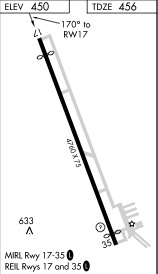
Runways
Runway Summary
| Runways: | 17/35 |
| Longest Runway: | 17/35 is 4760 ft (1451 m) long |
| Runways with an Instrument Approach: |
SEG Airport Runway Details
| Runway 17/35 | 4760 ft x 75 ft (1451 m x 23 m) | |
| Runway Length Source: | 3RD PARTY SURVEY as of 01/24/2014 | |
| Surface: | Asphalt - Excellent condition - No special surface treatment | |
| Runway Edge Lights: | Medium Intensity | |
Runway Weight Bearing Capacity (in thousands of pounds) |
||
| Single Wheel Landing Gear: | 27.0 | |
| Dual Wheel Landing Gear: | 27.0 | |
Runway 17 |
Runway 35 |
|
Elevation: |
463.5 | 441.9 |
Latitude: |
40-49-38.3771N | 40-48-54.5287N |
Longitude: |
076-52-02.1493W | 076-51-39.7696W |
|
Runway True Alignment: |
159 | 339 |
Glide Path Angle: |
0.0 degrees | 3.5 degrees |
Traffic Pattern: |
Left | Left |
Runway Markings Type: |
Nonprecision Instrument | Nonprecision Instrument |
Runway Markings Condition: |
Good | Good |
Object at End: |
TREE | TREES |
Object Height: |
29 | 30 |
Distance from End: |
587 | 409 |
Object Centerline Offset: |
123 ft. left of centerline | 156 ft. right of centerline |
Visual Glide Slope Indicators: |
4-Light PAPI On Left Side Of Runway | |
REIL: |
Yes | Yes |
Threshold Crossing Height: |
45 | |
Threshold Elevation: |
456.2 | 442.8 |
Displaced Threshold: |
388 | 250 |
Threshold Latitude: |
40-49-34.8026N | 40-48-56.8277N |
Threshold Longitude: |
076-52-00.3247W | 076-51-40.9426W |
Services
Airframe Repair: |
Major |
Powerplant Repair: |
Major |
Bottled Oxygen: |
None |
Bulk Oxygen: |
None |
Fuel Available: |
100LL, Jet A |
Landing Fees: |
No |
Parking: |
Hangars and tiedowns available |
Maps & Diagrams
SEG Sectional
Flight Planning
at skyvector.com
at skyvector.com