Location
Latitude: |
43-57-00.6000N (43.950167) |
Longitude: |
111-41-04.9000W (-111.684694) |
Elevation: |
4966.0 feet MSL (1514 m MSL) |
Magnetic Variation: |
11.3 E (as of April 2024 from WMM2020 model) |
Time Zone: |
UTC -7.0 (Standard Time) UTC -6.0 (Daylight Savings Time) |
From City: |
01 N.M. SE of St. Anthony, Idaho |
Found On: |
Salt Lake City Chart |
FAA Region: |
ANM |
Contacts
Manager: |
Publicly owned: |
| DIRK FORBUSH 110 W MAIN ST. ANTHONY, ID 83445 208-313-6594 |
CITY OF ST. ANTHONY 110 W MAIN ST ST ANTHONY, ID 83445 208-624-3494 |
Operations
Airport Status: |
Operational |
Facility Use: |
Public |
Type: |
Airport |
Activation Date: |
07/1945 |
Control tower: |
No |
Attendance (Months/Days/Hours): |
Months/Days/Hours UNATTENDED |
Boundary ARTCC: |
ZLC (Salt Lake City) |
Responsible ARTCC: |
ZLC (Salt Lake City) |
Lighting Schedule: |
SEE RMK |
Segmented Circle Indicator: |
Yes |
Traffic Pattern Altitude (MSL): |
5966 feet (1818 m) |
NOTAMs Facility: |
BOI |
NOTAM-D Service: |
Yes |
International Airport of Entry: |
No |
Customs Landing Rights: |
No |
Military Landing Rights: |
No |
Civil/Military Joint Use: |
No |
Based Aircraft
| Single Engine: | 24 |
| GA Helicopters: | 1 |
| Ultralights: | 5 |
Annual Operations (as of 08/30/2023)
| Total Operations: | 4910 | |
| Air Taxi: | 90 | 1.8% |
| GA Local: | 1550 | 31.6% |
| GA Itinerant: | 3250 | 66.2% |
| Military Aircraft: | 20 | 0.4% |
Communications
| CTAF: | 122.900 |
Fixed Based Operators (FBOs) & Fuel
(Click on a business for detail)
Please help us keep this information up to date. This is a FREE SERVICE just like everything else on Airport Guide! If you see that a business needs to be added, modified, or deleted please fill out our Update Form.
To add, modify, or delete a business click here.
Please help us keep this information up to date. This is a FREE SERVICE just like everything else on Airport Guide! If you see that a business needs to be added, modified, or deleted please fill out our Update Form.
Area Code: 208 |
| Business Name | Frequency | Phone | Fuel Grade |
|---|---|---|---|
| St. Anthony Flying Service
Update FBO info |
624-3631, -7935 |
Flight Service Stations
| Primary | Alternate | |
| FSS on Field: | N | |
| FSS Name (ID): | Boise(BOI) | |
| Frequency: | ||
| Toll Free Phone: | 1-800-WX-BRIEF |
Instrument Procedures / Charts
Terminal Procedures are only available for airports in several countries with more being added all the time. If you are looking for a specific country's charts, please send an email to support(at)airportguide.com stating the country name. This will be used to prioritize the implementation.
Navigation Aids (Navaids) near U12
| Dist (NM) | ID | Morse Code | Name | Type | Freq | True Hdg | Mag Hdg |
|---|---|---|---|---|---|---|---|
| 24.1 | DBS | _ . . _ . . . . . . | Dubois | VORTAC | 116.90 | 290 | 279 |
| 24.7 | ID | . . _ . . | Uconn | NDB | 324 | 211 | 200 |
| 30.7 | IDA | . . _ . . . _ | Idaho Falls | VOR-DME | 113.85 | 212 | 201 |
| 37.4 | SWU | . . . . _ _ . . _ | Sweden | NDB | 350 | 213 | 202 |
| 43.0 | LO | . _ . . _ _ _ | Targy | NDB | 415 | 28 | 17 |
| 45.8 | JAC | . _ _ _ . _ _ . _ . | Jackson | VOR-DME | 115.40 | 115 | 104 |
| 49.7 | WYS | . _ _ _ . _ _ . . . | West Yellowstone | DME | 114.85 | 28 | 17 |
| 50.5 | ESY | . . . . _ . _ _ | Yellowstone | NDB | 338 | 28 | 17 |
| 58.8 | DNW | _ . . _ . . _ _ | Dunoir | VOR-DME | 117.20 | 96 | 85 |
| 69.4 | PI | . _ _ . . . | Tyhee | NDB | 383 | 211 | 200 |
| 77.3 | PIH | . _ _ . . . . . . . | Pocatello | VOR-DME | 112.60 | 213 | 202 |
| 79.1 | EKS | . _ . _ . . . | Ennis | NDB | 286 | 0 | 349 |
| 86.2 | DLN | _ . . . _ . . _ . | Dillon | VOR-DME | 113.00 | 334 | 322 |
Nearby Airports with Fuel
| Dist (NM) | Name (Airport IDs) | True Hdg | Mag Hdg | Fuel Grade |
|---|---|---|---|---|
| 8.7 | Rexburg-Madison County Airport (KRXE RXE) |
216 | 205 | 100LL, Jet A |
| 21.3 | Rigby Airport (U56) |
209 | 198 | 100LL |
| 28.3 | Driggs/Reed Meml Airport (KDIJ DIJ) |
115 | 104 | 100LL, Jet A+ |
| 31.1 | Idaho Falls Regional Airport (IDA KIDA IDA) |
212 | 201 | 100LL, Jet A-1 |
| 45.9 | Jackson Hole Airport (JAC KJAC JAC) |
116 | 105 | 100LL, Jet A |
| 50.5 | Yellowstone Airport (WYS KWYS WYS) |
28 | 17 | 100LL, Jet A-1+ |
| 53.0 | Mccarley Field Airport (U02) |
213 | 202 | 100LL |
| 74.0 | Pocatello Regional Airport (PIH KPIH PIH) |
212 | 201 | 100LL, Jet A-1, Jet A-1+ |
| 74.4 | Arco-Butte County Airport (KAOC AOC) |
254 | 242 | 100LL |
| 77.2 | Gardiner Airport (29S) |
30 | 19 | 100ll Jet A |
| 78.2 | Allen H Tigert Airport (U78) |
176 | 165 | 100LL |
| 79.5 | Ennis Big Sky Airport (KEKS EKS) |
1 | 350 | 100LL, Jet A-1, Jet A-1+ |
| 81.2 | Afton Municipal Airport (AFO KAFO AFO) |
156 | 145 | 100LL, Jet A |
| 85.2 | American Falls Airport (U01) |
216 | 204 | 100LL |
| 86.6 | Dillon Airport (DLN KDLN DLN) |
334 | 322 | 100LL, Jet A |
| 89.7 | Dubois Municipal Airport (KDUB DUB) |
104 | 94 | 100LL, Jet A |
Notices to Airmen (NOTAMS)
Remarks
| A110-1 | ACFT OPER FROM GRAVEL RWY SE OF PAVED RWY DURING AGRI SEASON. |
| A110-2 | FOR CD CTC SALT LAKE ARTCC AT 801-320-2568. |
| A17 | UNATNDD |
| A42-04 | RWY 04 RY 04/22 NO DSPLCD THLD ARROW MARKINGS ON DSPLCD THLD. |
| A51-04 | 04/22 DSPLCD THRS MKD BY DSPLCD THR LGTS ONLY. |
| A52-22 | NMRS ADDNL OBSTNS AT 200 FT INCL FENCES, BLDGS, TREES, ROADS, ETC. |
| A57-04 | 25:1 TO DSPLCD THR. |
| A57-22 | 21:1 TO DSPLCD THLD. |
| A58-04 | +5 FT FENCE AT 0 FT; 50 FT L. +8' BERM AT 0', 70' L. |
| A58-22 | NMRS CLOSE-IN OBSTS (TREES & STRUCTURES) LCTD IN PRI SFC. |
| A70-FUEL-10 | 0LL FUEL 24 HR CREDIT CARD SVC AVBL. |
| A81-APT | ACTVT MIRL RY 04/22 - CTAF. |
| A81-BCN | ACTVT BCN - CTAF. |
| A84 | SEGMENTED CRC IS NSTD - PAINTED TIRES. |
| E111 | ESTABD PRIOR TO 15 MAY 1959. |
Runways
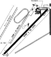
Runway Summary
| Runways: | 04/22 |
| Longest Runway: | 04/22 is 4500 ft (1372 m) long |
| Runways with an Instrument Approach: |
U12 Airport Runway Details
| Runway 04/22 | 4500 ft x 50 ft (1372 m x 15 m) | |
| Surface: | Asphalt - Excellent condition - No special surface treatment | |
| Runway Edge Lights: | Medium Intensity | |
Runway 04 |
Runway 22 |
|
Latitude: |
43-56-45.6200N | 43-57-15.5800N |
Longitude: |
111-41-27.6000W | 111-40-42.1500W |
Glide Path Angle: |
0.0 degrees | 0.0 degrees |
Traffic Pattern: |
Left | Left |
Runway Markings Type: |
Nonstandard (other than numbers only) | Nonstandard (other than numbers only) |
Runway Markings Condition: |
Good | Good |
Object at End: |
PLINE | TREE |
Object Height: |
70 | 55 |
Distance from End: |
1400 | 490 |
Object Centerline Offset: |
0 ft. left and right of centerline | 80 ft. left of centerline |
REIL: |
No | No |
Touchdown Lights: |
No | No |
Centerline Lights: |
No | No |
Displaced Threshold: |
300 | 540 |
Services
Airframe Repair: |
None |
Powerplant Repair: |
None |
Bottled Oxygen: |
None |
Bulk Oxygen: |
None |
Fuel Available: |
100LL, Jet A |
Landing Fees: |
No |
Parking: |
Tiedowns available |
Maps & Diagrams
U12 Sectional
Flight Planning
at skyvector.com
at skyvector.com