Location
Latitude: |
26-00-04.4000N (26.001222) |
Longitude: |
080-14-26.6000W (-80.240722) |
Elevation: |
8.5 feet MSL (3 m MSL) |
Magnetic Variation: |
7.2 W (as of May 2024 from WMM2020 model) |
Time Zone: |
UTC -5.0 (Standard Time) UTC -4.0 (Daylight Savings Time) |
From City: |
05 N.M. W of Hollywood, Florida |
Found On: |
Miami Chart |
FAA Region: |
ASO |
Contacts
Manager: |
Publicly owned: |
| NINA MACPHERSON 101 SOUTHWEST 77TH WAY PEMBROKE PINES, FL 33023 954-359-1016 |
BROWARD COUNTY 320 TERMINAL DR SUITE 200 FT LAUDERDALE, FL 33315 954-359-6100 |
Operations
Airport Status: |
Operational |
Facility Use: |
Public |
Type: |
Airport |
Activation Date: |
12/1944 |
Control tower: |
Yes |
Attendance (Months/Days/Hours): |
Months/Days/Hours ALL/ALL/0700-2100 |
Boundary ARTCC: |
ZMA (Miami) |
Responsible ARTCC: |
ZMA (Miami) |
Lighting Schedule: |
SEE RMK |
Segmented Circle Indicator: |
Yes, Lighted |
Traffic Pattern Altitude (MSL): |
1008 feet (307 m) |
NOTAMs Facility: |
HWO |
NOTAM-D Service: |
Yes |
International Airport of Entry: |
No |
Customs Landing Rights: |
No |
Military Landing Rights: |
Yes |
Civil/Military Joint Use: |
No |
Based Aircraft
| Single Engine: | 348 |
| Multi Engine: | 53 |
| Jet Engine: | 1 |
| GA Helicopters: | 19 |
| Gliders: | 1 |
| Ultralights: | 1 |
Annual Operations (as of 05/02/2018)
| Total Operations: | 117649 | |
| Air Taxi: | 84 | 0.1% |
| GA Local: | 72144 | 61.3% |
| GA Itinerant: | 45229 | 38.4% |
| Military Aircraft: | 192 | 0.2% |
Communications
| CTAF: | 132.100 |
| Unicom: | 122.950 |
| Tower: | NORTH PERRY 132.1 254.3 134.3 Hrs: 0700-2100 |
| Ground: | 120.45 254.3 |
| Approach: | MIAMI |
| Departure: | MIAMI |
| ATIS: | 135.475 Hrs: 24 |
| ASOS: | (954-983-5904) |
- MIAMI APCH/DEP FREQS USABLE 4000' AND BELOW.
Fixed Based Operators (FBOs) & Fuel
(Click on a business for detail)
Please help us keep this information up to date. This is a FREE SERVICE just like everything else on Airport Guide! If you see that a business needs to be added, modified, or deleted please fill out our Update Form.
To add, modify, or delete a business click here.
Please help us keep this information up to date. This is a FREE SERVICE just like everything else on Airport Guide! If you see that a business needs to be added, modified, or deleted please fill out our Update Form.
Area Code: 954 |
| Business Name | Frequency | Phone | Fuel Grade |
|---|---|---|---|
| Aerial Banners, Inc.
Website Update FBO info |
954-893-0099 | ||
| Air Superiority
Website Update FBO info |
(954) 961-7721 | 100LL | |

|
100LL - 2.15 USD per gallon on 11/16/01 |
24 Hour Self Serve Credit Card Pumps $2.30 Full Service |
|
| Broward Comm. College Aviation Institute
Update FBO info |
986-8080, -8084 | ||
| Crescent Helicopters
Update FBO info |
987-1900 | 100LL, Jet A | |
| Florida Suncoast Aviation
Update FBO info |
Unicom 122.95 | 985-8303, 964-7706, 800-753-1992 | 100LL |
| Hollywood Aviation, Inc.
Update FBO info |
Unicom 122.95 | 963-5820, -5821 | 100LL |
| Pelican Airways
Update FBO info |
Unicom 122.95 | 966-9750, 305-940-4086 | |
| Rotors in Motion
Update FBO info |
Arinc 129.57 | 981-4000, pager 800-874-8751 | |
| Socata Aircraft
Update FBO info |
893-1400 | ||
| Southern Airparks, Inc.
Update FBO info |
981-4000, pager 800-874-8751 |
Flight Service Stations
| Primary | Alternate | |
| FSS on Field: | N | |
| FSS Name (ID): | Miami(MIA) | |
| Frequency: | ||
| Toll Free Phone: | 1-800-WX-BRIEF |
Instrument Procedures / Charts
FAA Terminal Procedures valid from 0901Z 03/21/24 to 0901Z 04/18/24.
There are various types of charts available for an airport. They are listed in the Page Type column. Here is a legend for those types:
APD - Airport Diagram
DP - Departure Procedure Charts
HOT - Hot Spots
IAP - Instrument Approach Procedure Charts
MIN - Minimums
STAR - Standard Terminal Arrival Charts
| Page Type | Page Name | Volume | Action Since Last Cycle |
|---|---|---|---|
| APD | AIRPORT DIAGRAM | SE-3 | |
| DP | MIAMI NINE | SE-3 | Changed |
| DP | MIAMI NINE[DELIMITER] CONT.1 | SE-3 | |
| HOT | HOT SPOT | SE-3 | |
| IAP | RNAV (GPS) RWY 10R | SE-3 | |
| IAP | RNAV (GPS) RWY 28R | SE-3 | |
| MIN | TAKEOFF MINIMUMS | SE-3 | |
| STAR | BLUFI FOUR | SE-3 | Changed |
| STAR | DEKAL EIGHT | SE-3 | Changed |
| STAR | FORTL NINE | SE-3 | Changed |
| STAR | KYAKS THREE (RNAV) | SE-3 | |
| STAR | KYAKS THREE (RNAV)[DELIMITER] CONT.1 | SE-3 | |
| STAR | TARPN THREE (RNAV) | SE-3 | |
| STAR | TOREZ ONE (RNAV) | SE-3 |
Terminal Procedures are only available for airports in several countries with more being added all the time. If you are looking for a specific country's charts, please send an email to support(at)airportguide.com stating the country name. This will be used to prioritize the implementation.
Navigation Aids (Navaids) near HWO
| Dist (NM) | ID | Morse Code | Name | Type | Freq | True Hdg | Mag Hdg |
|---|---|---|---|---|---|---|---|
| 5.9 | FLL | . . _ . . _ . . . _ . . | Fort Lauderdale | VOR-DME | 114.40 | 42 | 49 |
| 11.5 | FX | . . _ . _ . . _ | Praiz | NDB | 221 | 344 | 351 |
| 12.6 | MIA | _ _ . . . _ | Miami Intl | VOT | 112.00 | 189 | 196 |
| 13.4 | DHP | _ . . . . . . . _ _ . | Dolphin | VORTAC | 113.90 | 205 | 212 |
| 15.7 | VKZ | . . . _ _ . _ _ _ . . | Virginia Key | VOR-DME | 117.10 | 162 | 169 |
| 25.9 | TM | _ _ _ | Qeezy | NDB | 266 | 213 | 220 |
| 31.6 | HST | . . . . . . . _ | Homestead | TACAN | 108.20 | 193 | 200 |
| 41.6 | PBI | . _ _ . _ . . . . . | Palm Beach | VORTAC | 115.70 | 11 | 18 |
| 41.8 | PBI | . _ _ . _ . . . . . | Palm Beach | VOT | 109.00 | 10 | 17 |
| 42.4 | TN | _ _ . | Monry | NDB | 227 | 258 | 265 |
| 52.8 | PHK | . _ _ . . . . . _ . _ | Pahokee | VOR-DME | 115.40 | 332 | 339 |
| 54.1 | ZBV | _ _ . . _ . . . . . . _ | Bimini | VORTAC | 116.70 | 109 | 116 |
| 54.7 | UTX | . . _ _ _ . . _ | United | NDB | 405 | 354 | 361 |
| 79.3 | LBV | . _ . . _ . . . . . . _ | La Belle | VORTAC | 110.40 | 309 | 316 |
| 83.4 | CYY | _ . _ . _ . _ _ _ . _ _ | Cypress | VOR-DME | 108.60 | 276 | 283 |
| 84.7 | ZFP | _ _ . . . . _ . . _ _ . | Freeport | NDB | 209 | 68 | 76 |
| 88.5 | RSW | . _ . . . . . _ _ | Lee County | VORTAC | 114.15 | 291 | 298 |
| 89.4 | FPR | . . _ . . _ _ . . _ . | Fort Pierce | NDB | 275 | 355 | 362 |
| 89.4 | ZFP | _ _ . . . . _ . . _ _ . | Freeport | VOR-DME | 113.20 | 67 | 75 |
| 90.2 | MTH | _ _ _ . . . . | Marathon | NDB | 260 | 211 | 218 |
Nearby Airports with Fuel
Notices to Airmen (NOTAMS)
Remarks
| A11 | CONTACT PERSON: MARK GALE A.A.E. 954-359-6100 |
| A110-1 | ARPT CLSD TO ACFT OVER 12500 LBS MAX CERTD TOG. |
| A110-2 | NUMEROUS TALL TOWERS SE OF ARPT CAUSE RADIO INTFC. |
| A110-4 | HIGH VOL OF BANNER TOWING AND STUDENT FLT INVOF ARPT. |
| A110-5 | BIRD ACTIVITY ON & INVOF AIRPORT. |
| A110-6 | RWY CONDITION NOT MONITORED WHEN TOWER CLOSED. |
| A57-01L | RY 01L APCH SLOPE 34:1 TO THE DSPLCD THLD. |
| A57-01R | RWY 01R APCH SLOPE 27:1 TO THE DSPLCD THR. |
| A57-10L | RWY 10L APCH SLOPE 25:1 TO THE DSPLCD THR. |
| A57-10R | RY 10R APCH SLOPE 32:1 TO THE DSPLCD THLD. |
| A57-19L | RY 19L APCH SLOPE 28:1 TO THE DSPLCD THLD. |
| A57-19R | RWY 19R APCH SLOPE 31:1 TO THE DSPLCD THR. |
| A57-28L | RWY 28L APCH SLOPE 30:1 TO THE DSPLCD THR. |
| A57-28R | RWY 28R APCH SLOPE 31:1 TO THE DSPLCD THR. |
| A81-APT | ATC-CTL. WHEN ATCT CLSD ACTVT MIRL RWY 10R/28L, 01L/19R - CTAF. |
| E111 | VFR OPERS ONLY |
Runways
Runway Summary
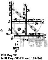
| Runways: | 01L/19R 01R/19L 10L/28R 10R/28L |
| Longest Runway: | 01L/19R is 3350 ft (1021 m) long |
| Runways with an Instrument Approach: |
HWO Airport Runway Details
| Runway 01L/19R | 3350 ft x 100 ft (1021 m x 30 m) | |
| Runway Length Source: | 3RD PARTY SURVEY as of 01/16/2016 | |
| Surface: | Asphalt - Good condition - No special surface treatment | |
| Runway Pavement Class: | 31 /F/A/X/T | |
| Runway Edge Lights: | Medium Intensity | |
Runway Weight Bearing Capacity (in thousands of pounds) |
||
| Single Wheel Landing Gear: | 85.0 | |
| Dual Wheel Landing Gear: | 131.0 | |
Runway 01L |
Runway 19R |
|
Elevation: |
7.6 | 7.2 |
Latitude: |
25-59-52.1899N | 26-00-25.3701N |
Longitude: |
080-14-38.6760W | 080-14-38.4588W |
|
Runway True Alignment: |
000 | 180 |
Glide Path Angle: |
3.5 degrees | 3.5 degrees |
Traffic Pattern: |
Left | Right |
Runway Markings Type: |
Basic | Basic |
Runway Markings Condition: |
Good | Good |
Object at End: |
TREE | TREE |
Object Height: |
45 | 52 |
Distance from End: |
1170 | 1240 |
Object Centerline Offset: |
85 ft. left of centerline | 75 ft. left of centerline |
Visual Glide Slope Indicators: |
2-Light PAPI On Left Side Of Runway | 2-Light PAPI On Left Side Of Runway |
REIL: |
Yes | Yes |
Touchdown Lights: |
No | No |
Centerline Lights: |
No | No |
Threshold Crossing Height: |
40 | 24 |
Threshold Elevation: |
7.2 | 7.3 |
Displaced Threshold: |
350 | 350 |
Threshold Latitude: |
25-59-55.6556N | 26-00-21.9050N |
Threshold Longitude: |
080-14-38.6532W | 080-14-38.4799W |
| Runway 01R/19L | 3260 ft x 100 ft (994 m x 30 m) | |
| Runway Length Source: | 3RD PARTY SURVEY as of 01/16/2016 | |
| Surface: | Asphalt - Good condition - No special surface treatment | |
| Runway Pavement Class: | 9 /F/B/Y/T | |
Runway Weight Bearing Capacity (in thousands of pounds) |
||
| Single Wheel Landing Gear: | 29.5 | |
| Dual Wheel Landing Gear: | 45.0 | |
Runway 01R |
Runway 19L |
|
Elevation: |
7.3 | 6.8 |
Latitude: |
25-59-51.1126N | 26-00-23.4022N |
Longitude: |
080-14-22.7849W | 080-14-22.5721W |
|
Runway True Alignment: |
000 | 180 |
Glide Path Angle: |
3.5 degrees | 3.5 degrees |
Traffic Pattern: |
Right | Left |
Runway Markings Type: |
Basic | Basic |
Runway Markings Condition: |
Fair | Fair |
Object at End: |
TREE | TREE |
Object Height: |
46 | 54 |
Distance from End: |
1045 | 1380 |
Object Centerline Offset: |
85 ft. left of centerline | 75 ft. left of centerline |
Visual Glide Slope Indicators: |
2-Light PAPI On Left Side Of Runway | 2-Light PAPI On Left Side Of Runway |
REIL: |
No | No |
Touchdown Lights: |
No | No |
Centerline Lights: |
No | No |
Threshold Crossing Height: |
40 | 33 |
Threshold Elevation: |
7.6 | 6.9 |
Displaced Threshold: |
185 | 111 |
Threshold Latitude: |
25-59-52.9475N | 26-00-22.3061N |
Threshold Longitude: |
080-14-22.7761W | 080-14-22.5776W |
| Runway 10L/28R | 3241 ft x 100 ft (988 m x 30 m) | |
| Runway Length Source: | 3RD PARTY SURVEY as of 01/16/2016 | |
| Surface: | Asphalt - Good condition - No special surface treatment | |
| Runway Pavement Class: | 7 /F/B/Y/T | |
Runway Weight Bearing Capacity (in thousands of pounds) |
||
| Single Wheel Landing Gear: | 24.0 | |
| Dual Wheel Landing Gear: | 38.5 | |
Runway 10L |
Runway 28R |
|
Elevation: |
6.9 | 7.5 |
Latitude: |
26-00-08.1582N | 26-00-07.9671N |
Longitude: |
080-14-41.2144W | 080-14-05.6925W |
|
Runway True Alignment: |
090 | 270 |
Glide Path Angle: |
3.5 degrees | 3.5 degrees |
Traffic Pattern: |
Left | Right |
Runway Markings Type: |
Basic | Nonprecision Instrument |
Runway Markings Condition: |
Fair | Fair |
Object at End: |
TREE | TREES |
Object Height: |
61 | 42 |
Distance from End: |
1335 | 1145 |
Object Centerline Offset: |
85 ft. left of centerline | 75 ft. left of centerline |
Visual Glide Slope Indicators: |
2-Light PAPI On Left Side Of Runway | 2-Light PAPI On Left Side Of Runway |
REIL: |
No | No |
Touchdown Lights: |
No | No |
Centerline Lights: |
No | No |
Threshold Crossing Height: |
40 | 39 |
Threshold Elevation: |
6.9 | 7.7 |
Displaced Threshold: |
181 | 61 |
Threshold Latitude: |
26-00-08.1483N | 26-00-07.9727N |
Threshold Longitude: |
080-14-39.2328W | 080-14-06.3587W |
| Runway 10R/28L | 3255 ft x 100 ft (992 m x 30 m) | |
| Runway Length Source: | 3RD PARTY SURVEY as of 01/16/2016 | |
| Surface: | Asphalt - Good condition - No special surface treatment | |
| Runway Pavement Class: | 31 /F/A/X/T | |
| Runway Edge Lights: | Medium Intensity | |
Runway Weight Bearing Capacity (in thousands of pounds) |
||
| Single Wheel Landing Gear: | 85.0 | |
| Dual Wheel Landing Gear: | 131.0 | |
Runway 10R |
Runway 28L |
|
Elevation: |
6.9 | 7.8 |
Latitude: |
25-59-53.6267N | 25-59-53.4356N |
Longitude: |
080-14-39.2076W | 080-14-03.5372W |
|
Runway True Alignment: |
090 | 270 |
Glide Path Angle: |
3.5 degrees | 3.5 degrees |
Traffic Pattern: |
Right | Left |
Runway Markings Type: |
Nonprecision Instrument | Basic |
Runway Markings Condition: |
Good | Good |
Object at End: |
BLDG | TREE |
Object Height: |
59 | 53 |
Object Marked/Lighted?: |
Lighted | |
Distance from End: |
1618 | 1375 |
Object Centerline Offset: |
85 ft. left of centerline | 75 ft. left of centerline |
Visual Glide Slope Indicators: |
4-Light PAPI On Left Side Of Runway | 2-Light PAPI On Left Side Of Runway |
REIL: |
Yes | Yes |
Touchdown Lights: |
No | No |
Centerline Lights: |
No | No |
Threshold Crossing Height: |
45 | 24 |
Threshold Elevation: |
7.7 | 7.9 |
Displaced Threshold: |
255 | 210 |
Threshold Latitude: |
25-59-53.6139N | 25-59-53.4516N |
Threshold Longitude: |
080-14-36.4134W | 080-14-05.8380W |
Services
Airframe Repair: |
Minor |
Powerplant Repair: |
Major |
Bottled Oxygen: |
None |
Bulk Oxygen: |
None |
Fuel Available: |
100LL, Jet A |
Landing Fees: |
No |
Parking: |
Tiedowns available |
Maps & Diagrams
HWO Sectional
Flight Planning
at skyvector.com
at skyvector.com