Location
Latitude: |
26-22-42.5480N (26.378486) |
Longitude: |
080-06-27.7070W (-80.107696) |
Elevation: |
12.9 feet MSL (4 m MSL) |
Magnetic Variation: |
7.3 W (as of April 2024 from WMM2020 model) |
Time Zone: |
UTC -5.0 (Standard Time) UTC -4.0 (Daylight Savings Time) |
From City: |
02 N.M. NW of Boca Raton, Florida |
Found On: |
Miami Chart |
FAA Region: |
ASO |
Contacts
Manager: |
Publicly owned: |
| CLARA BENNETT 903 NW 35TH STREET BOCA RATON, FL 33431 561-391-2202 |
BOCA RATON AIRPORT AUTHORITY 903 NW 35TH STREET BOCA RATON, FL 33431 561-391-2202 |
Operations
Airport Status: |
Operational |
Facility Use: |
Public |
Type: |
Airport |
Activation Date: |
04/1940 |
Control tower: |
Yes |
Attendance (Months/Days/Hours): |
Months/Days/Hours ALL/ALL/ALL |
Boundary ARTCC: |
ZMA (Miami) |
Responsible ARTCC: |
ZMA (Miami) |
Lighting Schedule: |
SEE RMK |
Segmented Circle Indicator: |
No |
Traffic Pattern Altitude (MSL): |
1013 feet (309 m) |
NOTAMs Facility: |
MIA |
NOTAM-D Service: |
Yes |
International Airport of Entry: |
No |
Customs Landing Rights: |
No |
Military Landing Rights: |
Yes |
Civil/Military Joint Use: |
No |
Based Aircraft
| Single Engine: | 115 |
| Multi Engine: | 23 |
| Jet Engine: | 75 |
| GA Helicopters: | 5 |
Annual Operations (as of 04/30/2018)
| Total Operations: | 81550 | |
| Air Taxi: | 5289 | 6.5% |
| GA Local: | 42791 | 52.5% |
| GA Itinerant: | 33367 | 40.9% |
| Military Aircraft: | 103 | 0.1% |
Communications
| CTAF: | 118.425 |
| Tower: | BOCA RATON 118.425 Hrs: 0700-2300 |
| Clearance Del.: | 121.8 |
| Ground: | 121.8 |
| Approach: | PALM BEACH |
| Departure: | PALM BEACH |
| AWOS-3: | 121.125 (561-391-2696) |
Fixed Based Operators (FBOs) & Fuel
(Click on a business for detail)
Please help us keep this information up to date. This is a FREE SERVICE just like everything else on Airport Guide! If you see that a business needs to be added, modified, or deleted please fill out our Update Form.
To add, modify, or delete a business click here.
Please help us keep this information up to date. This is a FREE SERVICE just like everything else on Airport Guide! If you see that a business needs to be added, modified, or deleted please fill out our Update Form.
Area Code: 561 |
| Business Name | Frequency | Phone | Fuel Grade |
|---|---|---|---|
| Boca Aircraft Owners-THE HANGAR PEOPLE
Update FBO info |
Unicom 122.8 | 995-9633 | |
| Boca Aviation
Update FBO info |
Unicom 122.8, Arinc 131.95 | 368-1110 | 100LL, Jet A |
| Boca National Aircraft, Inc.
Update FBO info |
998-8044 | ||
| Boca Raton Composite Squadron, Civil Air Patrol (CAP), U.S. Air Force Auxiliary
Update FBO info |
|||
| Lynn University
Update FBO info |
237-7331 | ||
| Signature Flight Support
Update FBO info |
Unicom: 118.43, Arinc: 130.9 | +1 561 955 9556 | 100LL, Jet A |
| USA Transportation | Dav El of South Florida
Website Update FBO info |
561-687-9454 |
Flight Service Stations
| Primary | Alternate | |
| FSS on Field: | N | |
| FSS Name (ID): | Miami(MIA) | |
| Frequency: | ||
| Toll Free Phone: | 1-800-WX-BRIEF |
Instrument Procedures / Charts
FAA Terminal Procedures valid from 0901Z 03/21/24 to 0901Z 04/18/24.
There are various types of charts available for an airport. They are listed in the Page Type column. Here is a legend for those types:
APD - Airport Diagram
DP - Departure Procedure Charts
HOT - Hot Spots
IAP - Instrument Approach Procedure Charts
MIN - Minimums
STAR - Standard Terminal Arrival Charts
| Page Type | Page Name | Volume | Action Since Last Cycle |
|---|---|---|---|
| APD | AIRPORT DIAGRAM | SE-3 | |
| DP | MYZNR TWO (RNAV) | SE-3 | |
| DP | TURPS TWO (RNAV) | SE-3 | |
| IAP | RNAV (GPS) RWY 05 | SE-3 | |
| IAP | RNAV (GPS) Y RWY 23 | SE-3 | |
| IAP | RNAV (RNP) Z RWY 23 | SE-3 | |
| MIN | ALTERNATE MINIMUMS | SE-3 | |
| MIN | TAKEOFF MINIMUMS | SE-3 | |
| STAR | CLMNT TWO (RNAV) | SE-3 | |
| STAR | CLMNT TWO (RNAV)[DELIMITER] CONT.1 | SE-3 | |
| STAR | CLMNT TWO (RNAV)[DELIMITER] CONT.2 | SE-3 | |
| STAR | CPTAN THREE (RNAV) | SE-3 | |
| STAR | CPTAN THREE (RNAV)[DELIMITER] CONT.1 | SE-3 | |
| STAR | CPTAN THREE (RNAV)[DELIMITER] CONT.2 | SE-3 | |
| STAR | JESTR ONE (RNAV) | SE-3 | |
| STAR | JESTR ONE (RNAV)[DELIMITER] CONT.1 | SE-3 | |
| STAR | MAHHI THREE (RNAV) | SE-3 | |
| STAR | MAHHI THREE (RNAV)[DELIMITER] CONT.1 | SE-3 | |
| STAR | MELBOURNE TWO | SE-3 | Changed |
| STAR | STOOP THREE | SE-3 | Changed |
| STAR | TTYLR THREE | SE-3 | Changed |
| STAR | VUUDU ONE (RNAV) | SE-3 | |
| STAR | VUUDU ONE (RNAV)[DELIMITER] CONT.1 | SE-3 | |
| STAR | VUUDU ONE (RNAV)[DELIMITER] CONT.2 | SE-3 |
Terminal Procedures are only available for airports in several countries with more being added all the time. If you are looking for a specific country's charts, please send an email to support(at)airportguide.com stating the country name. This will be used to prioritize the implementation.
Navigation Aids (Navaids) near BCT
| Dist (NM) | ID | Morse Code | Name | Type | Freq | True Hdg | Mag Hdg |
|---|---|---|---|---|---|---|---|
| 15.5 | FX | . . _ . _ . . _ | Praiz | NDB | 221 | 221 | 228 |
| 18.1 | PBI | . _ _ . _ . . . . . | Palm Beach | VORTAC | 115.70 | 3 | 10 |
| 18.5 | PBI | . _ _ . _ . . . . . | Palm Beach | VOT | 109.00 | 0 | 7 |
| 18.5 | FLL | . . _ . . _ . . . _ . . | Fort Lauderdale | VOR-DME | 114.40 | 189 | 196 |
| 34.1 | UTX | . . _ _ _ . . _ | United | NDB | 405 | 339 | 346 |
| 36.2 | MIA | _ _ . . . _ | Miami Intl | VOT | 112.00 | 194 | 201 |
| 37.1 | DHP | _ . . . . . . . _ _ . | Dolphin | VORTAC | 113.90 | 200 | 207 |
| 37.7 | VKZ | . . . _ _ . _ _ _ . . | Virginia Key | VOR-DME | 117.10 | 183 | 190 |
| 39.6 | PHK | . _ _ . . . . . _ . _ | Pahokee | VOR-DME | 115.40 | 307 | 314 |
| 49.1 | TM | _ _ _ | Qeezy | NDB | 266 | 205 | 212 |
| 55.3 | HST | . . . . . . . _ | Homestead | TACAN | 108.20 | 195 | 202 |
| 57.7 | TN | _ _ . | Monry | NDB | 227 | 237 | 244 |
| 59.7 | ZBV | _ _ . . _ . . . . . . _ | Bimini | VORTAC | 116.70 | 132 | 140 |
| 68.0 | FPR | . . _ . . _ _ . . _ . | Fort Pierce | NDB | 275 | 347 | 354 |
| 72.1 | ZFP | _ _ . . . . _ . . _ _ . | Freeport | NDB | 209 | 83 | 91 |
| 74.0 | LBV | . _ . . _ . . . . . . _ | La Belle | VORTAC | 110.40 | 291 | 298 |
| 76.5 | ZFP | _ _ . . . . _ . . _ _ . | Freeport | VOR-DME | 113.20 | 81 | 89 |
| 78.4 | BHF | Islands | NDB | 326 | 81 | 89 | |
| 80.6 | TRV | _ . _ . . . . _ | Treasure | VORTAC | 117.30 | 345 | 352 |
| 90.1 | RSW | . _ . . . . . _ _ | Lee County | VORTAC | 114.15 | 276 | 283 |
Nearby Airports with Fuel
Notices to Airmen (NOTAMS)
Remarks
| A110-1 | NOISE ABATEMENT INFO - AMGR. VOLUNTARY NOISE ABATEMENT PROC IN EFCT ALL TIMES & ACFT. VOLUNTARY CURFEW 2200-0700. USE NBAA STD NOISE ABATEMENT APCH & DEP PROC. |
| A110-10 | FOR CD, IF UNA VIA GCO CTC PALM BEACH APCH AT 561-684-9047 OR 561-275-1430. |
| A110-11 | WHEN ATCT CLSD, GCO AVBL ON FREQ 127.35 PALM BEACH CD. |
| A110-2 | BIRDS ON AND INVOF ARPT. |
| A110-4 | USE RECOMMENDED DEP: RWY 05 L TURN HDG 360 STAY W OF INTERSTATE TO 1500 FT; RWY 23 R TURN HDG 255 AS SOON AS PRACTICABLE AFT PASSING RWY END TO 1500 FT; AVOID RESIDENTIAL AREAS; OVERFLY MALL AREA. |
| A110-5 | TGLS VOLUNTARILY RSTRD TO 0900-1700 MON-FRI; VOLUNTARY RESTRN ON STOP & GO LNDGS OR INT DEPS. VOLUNTARY RESTRN ON REPETITIVE PAT OPS. |
| A110-7 | MAINT RUNUP NA 0100-1300. |
| A110-8 | ACFT PRKG LTD DURG VIP TFR PDS. |
| A110-9 | US CUSTS USER FEE ARPT. US CUSTS AVBL THUR-MON 1030-1830 LCL - 561-292-9231. CLSD TO ARR OUTSIDE NML HR EXC O/R AND APVL BY US CUSTS; MNM ADDNL FEE. CTC US CUSTS 561-665-5842 FOR AFT HR APVL. |
| A16 | EXT 211 |
| A57-05 | APCH SLOPE 43:1 TO DSPLCD THLD DUE TO +26 FT TREE 60 FT RIGHT OF CNTRLN 675 FT FM RWY END. |
| A57-23 | APCH SLOPE 35:1 TO DSPLCD THLD DUE TO TREES 25 FT RIGHT; 890 FT FM END OF RWY. |
| A81-APT | WHEN ATCT CLSD ACTV REIL RWY 05 & 23, PAPI RWY 5 & 23; MIRL RWY 05/23 - CTAF. |
| E60-05 | ENGINEERED MATERIALS ARRESTING SYS (EMAS) 252 FT IN LEN BY 170 FT IN WID LCTD AT THE DER 05. |
| E60-23 | ENGINEERED MATERIALS ARRESTING SYS (EMAS) 300 FT IN LEN BY 170 FT IN WID LCTD AT THE DER 23. |
| E80 | US CUSTOMS USER FEE ARPT. |
Runways
Runway Summary
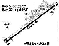
| Runways: | 05/23 |
| Longest Runway: | 05/23 is 6276 ft (1913 m) long |
| Runways with an Instrument Approach: |
BCT Airport Runway Details
| Runway 05/23 | 6276 ft x 150 ft (1913 m x 46 m) | |
| Runway Length Source: | 3RD PARTY SURVEY as of 07/20/2021 | |
| Surface: | Asphalt - Good condition - Saw-cut or plastic grooved | |
| Runway Pavement Class: | 32 /F/A/X/T | |
| Runway Edge Lights: | Medium Intensity | |
Runway Weight Bearing Capacity (in thousands of pounds) |
||
| Single Wheel Landing Gear: | 66.0 | |
| Dual Wheel Landing Gear: | 95.0 | |
Runway 05 |
Runway 23 |
|
Elevation: |
11.4 | 12.7 |
Latitude: |
26-22-20.3210N | 26-23-04.7733N |
Longitude: |
080-06-51.8246W | 080-06-03.5908W |
|
Runway True Alignment: |
044 | 224 |
Glide Path Angle: |
3.2 degrees | 3.2 degrees |
Traffic Pattern: |
Left | Right |
Runway Markings Type: |
Nonprecision Instrument | Nonprecision Instrument |
Runway Markings Condition: |
Fair | Fair |
Arresting Device: |
EMAS | EMAS |
Object at End: |
TREES | ROAD |
Object Height: |
33 | 15 |
Object Marked/Lighted?: |
Lighted | |
Distance from End: |
675 | 270 |
Object Centerline Offset: |
60 ft. right of centerline | 250 ft. right of centerline |
Visual Glide Slope Indicators: |
4-Light PAPI On Right Side Of Runway | 4-Light PAPI On Left Side Of Runway |
REIL: |
Yes | Yes |
Threshold Crossing Height: |
46 | 46 |
Threshold Elevation: |
11.6 | 12.7 |
Displaced Threshold: |
696 | 378 |
Threshold Latitude: |
26-22-25.2504N | 26-23-02.0939N |
Threshold Longitude: |
080-06-46.4735W | 080-06-06.4962W |
Declared Distances |
||
Take Off Run Avbl. (TORA): |
6276 | 6276 |
Take Off Distance Avbl. (TODA): |
6276 | 6276 |
Actual Stop Dist. Avbl. (ASDA): |
6276 | 6276 |
Landing Dist. Avbl. (LDA): |
5580 | 5898 |
Services
Airframe Repair: |
Minor |
Powerplant Repair: |
Major |
Bottled Oxygen: |
None |
Bulk Oxygen: |
None |
Fuel Available: |
100LL, Jet A |
Landing Fees: |
No |
Parking: |
Tiedowns available |
Maps & Diagrams
BCT Sectional
Flight Planning
at skyvector.com
at skyvector.com