Location
Latitude: |
25-54-26.7000N (25.907417) |
Longitude: |
080-16-41.6000W (-80.278222) |
Elevation: |
8.0 feet MSL (2 m MSL) |
Magnetic Variation: |
7.2 W (as of April 2024 from WMM2020 model) |
Time Zone: |
UTC -5.0 (Standard Time) UTC -4.0 (Daylight Savings Time) |
From City: |
10 N.M. N of Miami, Florida |
Found On: |
Miami Chart |
FAA Region: |
ASO |
Contacts
Manager: |
Publicly owned: |
| ELVIN HERNANDEZ 14201 NW LEJEUNE RD OPA-LOCKA, FL 33054 305-869-1662 |
MIAMI-DADE COUNTY MIAMI-DADE AVIATION DEPARTMENT, P.O. BOX 025504 MIAMI, FL 33102-5504 305-876-0464 |
Operations
Airport Status: |
Operational |
Facility Use: |
Public |
Type: |
Airport |
Activation Date: |
05/1941 |
Control tower: |
Yes |
Attendance (Months/Days/Hours): |
Months/Days/Hours ALL/ALL/ALL |
Boundary ARTCC: |
ZMA (Miami) |
Responsible ARTCC: |
ZMA (Miami) |
Lighting Schedule: |
SEE RMK |
Segmented Circle Indicator: |
Yes, Lighted |
Traffic Pattern Altitude (MSL): |
1008 feet (307 m) |
NOTAMs Facility: |
OPF |
NOTAM-D Service: |
Yes |
International Airport of Entry: |
No |
Customs Landing Rights: |
Yes |
Military Landing Rights: |
Yes |
Civil/Military Joint Use: |
No |
Based Aircraft
| Single Engine: | 35 |
| Multi Engine: | 13 |
| Jet Engine: | 10 |
| GA Helicopters: | 3 |
| Military Aircraft: | 5 |
Annual Operations (as of 05/03/2018)
| Total Operations: | 147638 | |
| Commercial: | 36 | 0.0% |
| Air Taxi: | 9494 | 6.4% |
| GA Local: | 47859 | 32.4% |
| GA Itinerant: | 81067 | 54.9% |
| Military Aircraft: | 9182 | 6.2% |
Communications
| CTAF: | 134.675 |
| Tower: | OPA LOCKA 134.675 Hrs: 0700-2300 |
| Clearance Del.: | 119.2 |
| Ground: | 120.025 |
| Approach: | MIAMI |
| Departure: | MIAMI |
| ATIS: | 125.9 Hrs: 24 |
| ASOS: | 125.9 (305-681-4063) |
Fixed Based Operators (FBOs) & Fuel
(Click on a business for detail)
Please help us keep this information up to date. This is a FREE SERVICE just like everything else on Airport Guide! If you see that a business needs to be added, modified, or deleted please fill out our Update Form.
To add, modify, or delete a business click here.
Please help us keep this information up to date. This is a FREE SERVICE just like everything else on Airport Guide! If you see that a business needs to be added, modified, or deleted please fill out our Update Form.
Area Code: 305 |
| Business Name | Frequency | Phone | Fuel Grade |
|---|---|---|---|
| Aerial Banners, Inc.
Website Update FBO info |
305-893-7587 | ||
| Air Repair
Update FBO info |
681-1278 | 100LL | |
| Avia Aero Services, Inc.
Website Update FBO info |
681-3110 | ||
| Endeavour Flight Training, Inc.
Website Update FBO info |
305-769-2779 | ||
| Miami Aviation Corporation
Update FBO info |
Unicom 122.95, Arinc 131.8 | 800-327-5725, 688-0511 | 100LL, Jet A |
| Miami Executive Aviation
Update FBO info |
687-8410 | 100LL, Jet A | |
| Miami-Dade Aviation Department
Website Update FBO info |
869-1660, 876-7862, night number 953-1300 | ||
| Signature Flight Support
Update FBO info |
Arinc: 129.85 | +1 305 687 8410 | |
| Wayman Aviation Flight School
Update FBO info |
685-6468 |
Flight Service Stations
| Primary | Alternate | |
| FSS on Field: | N | |
| FSS Name (ID): | Miami(MIA) | |
| Frequency: | ||
| Toll Free Phone: | 1-800-WX-BRIEF |
Instrument Procedures / Charts
FAA Terminal Procedures valid from 0901Z 03/21/24 to 0901Z 04/18/24.
There are various types of charts available for an airport. They are listed in the Page Type column. Here is a legend for those types:
APD - Airport Diagram
DP - Departure Procedure Charts
HOT - Hot Spots
IAP - Instrument Approach Procedure Charts
MIN - Minimums
STAR - Standard Terminal Arrival Charts
Terminal Procedures are only available for airports in several countries with more being added all the time. If you are looking for a specific country's charts, please send an email to support(at)airportguide.com stating the country name. This will be used to prioritize the implementation.
Navigation Aids (Navaids) near OPF
| Dist (NM) | ID | Morse Code | Name | Type | Freq | True Hdg | Mag Hdg |
|---|---|---|---|---|---|---|---|
| 6.8 | MIA | _ _ . . . _ | Miami Intl | VOT | 112.00 | 180 | 187 |
| 7.5 | DHP | _ . . . . . . . _ _ . | Dolphin | VORTAC | 113.90 | 210 | 217 |
| 11.5 | VKZ | . . . _ _ . _ _ _ . . | Virginia Key | VOR-DME | 117.10 | 144 | 151 |
| 11.7 | FLL | . . _ . . _ . . . _ . . | Fort Lauderdale | VOR-DME | 114.40 | 31 | 38 |
| 16.7 | FX | . . _ . _ . . _ | Praiz | NDB | 221 | 356 | 363 |
| 20.1 | TM | _ _ _ | Qeezy | NDB | 266 | 217 | 224 |
| 25.6 | HST | . . . . . . . _ | Homestead | TACAN | 108.20 | 192 | 199 |
| 39.7 | TN | _ _ . | Monry | NDB | 227 | 266 | 273 |
| 47.5 | PBI | . _ _ . _ . . . . . | Palm Beach | VORTAC | 115.70 | 12 | 19 |
| 47.7 | PBI | . _ _ . _ . . . . . | Palm Beach | VOT | 109.00 | 11 | 18 |
| 54.5 | ZBV | _ _ . . _ . . . . . . _ | Bimini | VORTAC | 116.70 | 102 | 109 |
| 57.0 | PHK | . _ _ . . . . . _ . _ | Pahokee | VOR-DME | 115.40 | 337 | 344 |
| 60.2 | UTX | . . _ _ _ . . _ | United | NDB | 405 | 357 | 364 |
| 81.4 | LBV | . _ . . _ . . . . . . _ | La Belle | VORTAC | 110.40 | 312 | 319 |
| 82.2 | CYY | _ . _ . _ . _ _ _ . _ _ | Cypress | VOR-DME | 108.60 | 280 | 287 |
| 84.3 | MTH | _ _ _ . . . . | Marathon | NDB | 260 | 211 | 218 |
| 88.8 | ZFP | _ _ . . . . _ . . _ _ . | Freeport | NDB | 209 | 65 | 73 |
| 88.8 | RSW | . _ . . . . . _ _ | Lee County | VORTAC | 114.15 | 295 | 302 |
| 93.5 | ZFP | _ _ . . . . _ . . _ _ . | Freeport | VOR-DME | 113.20 | 65 | 73 |
| 94.9 | FPR | . . _ . . _ _ . . _ . | Fort Pierce | NDB | 275 | 356 | 363 |
Nearby Airports with Fuel
Notices to Airmen (NOTAMS)
Remarks
| A11 | LONNY CRAVEN |
| A110*G | THIS AIRPORT HAS BEEN SURVEYED BY THE NATIONAL GEODETIC SURVEY. |
| A110-10 | TWY C & B SOUTH OF P ARE NON MOVEMENT AREAS. |
| A110-11 | ACFT WITH WINGSPANS GTR THAN 117 FT ARE PROHIBITED FM TXIG ON TWY P BTN TWY H AND TWY N8. |
| A110-12 | VEHICLE LANE XNG TWY E TO THE FIRE STN IS NON-MOVEMENT. |
| A110-13 | ALL ACFT AND VEHICLES SHUD RPRT PSNS TO ATC BY USING THE SFC PAINTED SPOT NRS ON ALL EXITS TO THE RAMP AND NON-MOVEMENT AREAS. |
| A110-14 | MILITARY FUEL: CONTRACT FUEL - 305-685-4646. |
| A110-15 | TWY T BTN TWY E AND TWY T8 RDCD SPD RQRD FOR ACFT WINGSPAN MORE THAN 117 FT. |
| A110-16 | TWY R BTN TWY F & G RSTRD TO ACFT WITH WINGSPAN LESS THAN 94 FT. |
| A110-17 | FOR CD, IF UNA VIA GCO, CTC MIAMI APCH AT 305-869-5432. |
| A110-18 | GCO AVBL ON FREQ 119.45. |
| A110-19 | US CBP AND EAPIS AVBL. 1400-0500Z++-305-687-5475.OPS MNT FREQ 134.675 DURING CTAF OPS. |
| A110-20 | RWY 09L-27R CLSD DLY 0400-1200Z++ EXC PPR 60 MINS-305-869-1660. RWY 09R-27L CLSD DLY 0400-1200Z++. |
| A110-21 | MILITARY REMARKS: CG OFFL BUS, MIN 24 HR PPR (AIR STN MIAMI OPS CNTR: D07-SMB-ODOAIRSTAMIA@USCG.MIL OR 305-953-2130). CTC MIAMI AIR 345.0 15 MIN PRIOR TO ENTERING CG RAMP. NO TRAN FAC. IF DESTN CG, INCL CGAS MIAMI IN RMK SEC OF FLT PLAN. |
| A110-3 | HEL ARR & DEP AVOID FLYING OVER PARKED OR TWY ACFT. |
| A110-5 | SPECIFIC TFC PATS ARE PUBLISHED FOR HEL AND FIXED WING TFC; COMPLIANCE IS MANDATORY. OBTAIN INFO FM ATCT OR FBO OR AMGR; OR REQ SPECIFIC TFC PAT INSTRUCTIONS ON INITIAL CTC. |
| A110-6 | DUAL TFC PATS FOR HELS & FIXED WING ACFT IN USE RWY 09R/27L. |
| A110-7 | BIRDS INVOF ARPT. |
| A110-8 | FLT NOTIFICATION SVC (ADCUS) AVBL 0800-2300. |
| A110-9 | NOISE SENSITIVE ARPT. FLT T IS LTD TO ACFT 40000 LBS MAX GROSS TKOF WT & BLW & ONLY BTN 0700-2300. |
| A30-09L/27R | CLSD DLY 0400-1200++ PPR 60 MINS - 305-869-1660 FOR ACFT NOISE ABATEMENT TO SRNDG ARPT COMMUNITY. |
| A30-09R/27L | CLSD DLY 0400-1200++ FOR ACFT NOISE ABATEMENT TO SRNDG ARPT COMMUNITY. |
| A57-12 | APCH SLOPE 50:1 TO DSPLCD THR. |
| A81-APT | WHEN ATCT CLSD ACTVT MALSR RWY 12; PAPI RWY 12 & 30; HIRL RWY 12/30 - CTAF. 30 MIN PPR TO REQ ACTVN OF MALSR RWY 09L; MALS RWY 27R; VASI RWY 9L & 27R; HIRL RWY 09L/27R - 305-869-1660 AND CTAF. |
Runways
Runway Summary
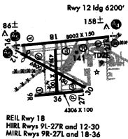
| Runways: | 09L/27R 09R/27L 12/30 |
| Longest Runway: | 09L/27R is 8002 ft (2439 m) long |
| Runways with an Instrument Approach: | 09L, 27R, 12 |
OPF Airport Runway Details
| Runway 09L/27R | 8002 ft x 150 ft (2439 m x 46 m) | |
| Runway Length Source: | NGS as of 01/18/2010 | |
| Surface: | Asphalt - Fair condition - Saw-cut or plastic grooved | |
| Runway Pavement Class: | 61 /F/A/W/T | |
| Runway Edge Lights: | High Intensity | |
Runway Weight Bearing Capacity (in thousands of pounds) |
||
| Single Wheel Landing Gear: | 120.0 | |
| Dual Wheel Landing Gear: | 249.0 | |
| Dual Tandem Wheel Landing Gear: | 484.0 | |
| Dual Dual Tandem Wheel Landing Gear: | 1000.0 | |
Runway 09L |
Runway 27R |
|
Elevation: |
6.8 | 7.3 |
Latitude: |
25-54-45.5280N | 25-54-49.7595N |
Longitude: |
080-17-19.2203W | 080-15-51.7062W |
|
Runway True Alignment: |
087 | 267 |
ILS Type: |
ILS | ILS/DME |
Glide Path Angle: |
3.0 degrees | 3.0 degrees |
Traffic Pattern: |
Left | Right |
Runway Markings Type: |
Precision Instrument | Precision Instrument |
Runway Markings Condition: |
Fair | Fair |
Object at End: |
TREES | TREES |
Object Height: |
51 | 47 |
Distance from End: |
2740 | 2550 |
Object Centerline Offset: |
430 ft. right of centerline | 500 ft. right of centerline |
Visual Glide Slope Indicators: |
4-Box VASI On Left Side Of Runway | 4-Box VASI On Left Side Of Runway |
Approach Light System: |
1,400 Foot Medium Intensity Approach Lighting System With Runway Alignment Indicator Lights | 1,400 Foot Medium Intensity Approach Lighting System |
Threshold Crossing Height: |
56 | 53 |
Declared Distances |
||
Take Off Run Avbl. (TORA): |
8002 | 8002 |
Take Off Distance Avbl. (TODA): |
8202 | 8202 |
Actual Stop Dist. Avbl. (ASDA): |
8202 | 8202 |
Landing Dist. Avbl. (LDA): |
8002 | 8002 |
| Runway 09R/27L | 4309 ft x 100 ft (1313 m x 30 m) | |
| Runway Length Source: | NGS as of 01/18/2010 | |
| Surface: | Asphalt - Fair condition - Saw-cut or plastic grooved | |
| Runway Pavement Class: | 36 /F/A/Y/T | |
| Runway Edge Lights: | Medium Intensity | |
Runway Weight Bearing Capacity (in thousands of pounds) |
||
| Single Wheel Landing Gear: | 96.0 | |
| Dual Wheel Landing Gear: | 154.0 | |
Runway 09R |
Runway 27L |
|
Elevation: |
5.8 | 5.8 |
Latitude: |
25-53-56.5425N | 25-53-58.7999N |
Longitude: |
080-17-06.6047W | 080-16-19.4883W |
|
Runway True Alignment: |
087 | 267 |
Glide Path Angle: |
3.0 degrees | 3.0 degrees |
Traffic Pattern: |
Right | Left |
Runway Markings Type: |
Basic | Basic |
Runway Markings Condition: |
Fair | Fair |
Object at End: |
POLE | TREES |
Object Height: |
35 | 45 |
Distance from End: |
1450 | 2395 |
Object Centerline Offset: |
430 ft. right of centerline | 500 ft. right of centerline |
Visual Glide Slope Indicators: |
4-Box VASI On Left Side Of Runway | 4-Light PAPI On Left Side Of Runway |
Threshold Crossing Height: |
26 | 50 |
Declared Distances |
||
Take Off Run Avbl. (TORA): |
4306 | 4306 |
Take Off Distance Avbl. (TODA): |
4306 | 4306 |
Actual Stop Dist. Avbl. (ASDA): |
4306 | 4306 |
Landing Dist. Avbl. (LDA): |
4306 | 4306 |
| Runway 12/30 | 6800 ft x 150 ft (2073 m x 46 m) | |
| Runway Length Source: | NGS as of 01/18/2010 | |
| Surface: | Asphalt - Fair condition - Saw-cut or plastic grooved | |
| Runway Pavement Class: | 61 /F/A/X/T | |
| Runway Edge Lights: | High Intensity | |
Runway Weight Bearing Capacity (in thousands of pounds) |
||
| Single Wheel Landing Gear: | 120.0 | |
| Dual Wheel Landing Gear: | 249.0 | |
| Dual Tandem Wheel Landing Gear: | 484.0 | |
| Dual Dual Tandem Wheel Landing Gear: | 1000.0 | |
Runway 12 |
Runway 30 |
|
Elevation: |
7.9 | 8.0 |
Latitude: |
25-54-38.1951N | 25-54-02.6679N |
Longitude: |
080-17-19.6070W | 080-16-16.3399W |
|
Runway True Alignment: |
122 | 302 |
ILS Type: |
ILS/DME | |
Glide Path Angle: |
3.0 degrees | 3.0 degrees |
Traffic Pattern: |
Left | Left |
Runway Markings Type: |
Precision Instrument | Nonprecision Instrument |
Runway Markings Condition: |
Fair | Fair |
Object at End: |
TREES | TREE |
Object Height: |
30 | 56 |
Distance from End: |
1375 | 1580 |
Object Centerline Offset: |
430 ft. right of centerline | 500 ft. right of centerline |
Visual Glide Slope Indicators: |
4-Light PAPI On Left Side Of Runway | 4-Light PAPI On Left Side Of Runway |
Approach Light System: |
1,400 Foot Medium Intensity Approach Lighting System With Runway Alignment Indicator Lights | |
Threshold Crossing Height: |
53 | 52 |
Threshold Elevation: |
7.9 | |
Displaced Threshold: |
800 | |
Threshold Latitude: |
25-54-34.0155N | |
Threshold Longitude: |
080-17-12.1627W | |
Declared Distances |
||
Take Off Run Avbl. (TORA): |
6800 | 6800 |
Take Off Distance Avbl. (TODA): |
7800 | 7000 |
Actual Stop Dist. Avbl. (ASDA): |
7000 | 7000 |
Landing Dist. Avbl. (LDA): |
6000 | 6800 |
Services
Airframe Repair: |
Minor |
Powerplant Repair: |
Major |
Bottled Oxygen: |
None |
Bulk Oxygen: |
None |
Fuel Available: |
100LL, Jet A |
Landing Fees: |
No |
Parking: |
Tiedowns available |
Maps & Diagrams
OPF Sectional
Flight Planning
at skyvector.com
at skyvector.com