Location
Latitude: |
25-38-51.2294N (25.647564) |
Longitude: |
080-25-59.6086W (-80.433224) |
Elevation: |
10.0 feet MSL (3 m MSL) |
Magnetic Variation: |
7 W (as of April 2024 from WMM2020 model) |
Time Zone: |
UTC -5.0 (Standard Time) UTC -4.0 (Daylight Savings Time) |
From City: |
13 N.M. SW of Miami, Florida |
Found On: |
Miami Chart |
FAA Region: |
ASO |
Contacts
Manager: |
Publicly owned: |
| JONATHAN SPICER 12800 SW 145TH AVE MIAMI, FL 33186 305-869-1702 |
MIAMI-DADE COUNTY MIAMI -DADE AVIATION DEPT., P.O. BOX 025504 MIAMI, FL 33102-5504 305-876-0464 |
Operations
Airport Status: |
Operational |
Facility Use: |
Public |
Type: |
Airport |
Activation Date: |
11/1967 |
Control tower: |
Yes |
Attendance (Months/Days/Hours): |
Months/Days/Hours ALL/ALL/ALL |
Boundary ARTCC: |
ZMA (Miami) |
Responsible ARTCC: |
ZMA (Miami) |
Lighting Schedule: |
SEE RMK |
Segmented Circle Indicator: |
Yes, Lighted |
Traffic Pattern Altitude (MSL): |
1010 feet (308 m) |
NOTAMs Facility: |
TMB |
NOTAM-D Service: |
Yes |
International Airport of Entry: |
No |
Customs Landing Rights: |
Yes |
Military Landing Rights: |
Yes |
Civil/Military Joint Use: |
No |
Based Aircraft
| Single Engine: | 104 |
| Multi Engine: | 17 |
| Jet Engine: | 5 |
| GA Helicopters: | 6 |
| Gliders: | 3 |
Annual Operations (as of 05/03/2018)
| Total Operations: | 194111 | |
| Air Taxi: | 1785 | 0.9% |
| GA Local: | 75866 | 39.1% |
| GA Itinerant: | 116394 | 60.0% |
| Military Aircraft: | 66 | 0.0% |
Communications
| CTAF: | 118.900 |
| Tower: | TAMIAMI 118.9 124.9 ;270-090 Hrs: 0700-2300 |
| Clearance Del.: | 133.0 |
| Ground: | 121.7 |
| Approach: | MIAMI |
| Departure: | MIAMI |
| ATIS: | 124.0 Hrs: 24 |
| ASOS: | 124.0 (305-235-1332) |
| VFR ADZY: | 118.9 |
Fixed Based Operators (FBOs) & Fuel
(Click on a business for detail)
Please help us keep this information up to date. This is a FREE SERVICE just like everything else on Airport Guide! If you see that a business needs to be added, modified, or deleted please fill out our Update Form.
click here.
Please help us keep this information up to date. This is a FREE SERVICE just like everything else on Airport Guide! If you see that a business needs to be added, modified, or deleted please fill out our Update Form.
Area Code: 305 |
Flight Service Stations
| Primary | Alternate | |
| FSS on Field: | N | |
| FSS Name (ID): | Miami(MIA) | |
| Frequency: | ||
| Toll Free Phone: | 1-800-WX-BRIEF |
Instrument Procedures / Charts
FAA Terminal Procedures valid from 0901Z 03/21/24 to 0901Z 04/18/24.
There are various types of charts available for an airport. They are listed in the Page Type column. Here is a legend for those types:
APD - Airport Diagram
DP - Departure Procedure Charts
HOT - Hot Spots
IAP - Instrument Approach Procedure Charts
MIN - Minimums
STAR - Standard Terminal Arrival Charts
Terminal Procedures are only available for airports in several countries with more being added all the time. If you are looking for a specific country's charts, please send an email to support(at)airportguide.com stating the country name. This will be used to prioritize the implementation.
Navigation Aids (Navaids) near TMB
| Dist (NM) | ID | Morse Code | Name | Type | Freq | True Hdg | Mag Hdg |
|---|---|---|---|---|---|---|---|
| 3.9 | TM | _ _ _ | Qeezy | NDB | 266 | 264 | 271 |
| 9.9 | HST | . . . . . . . _ | Homestead | TACAN | 108.20 | 162 | 169 |
| 10.2 | DHP | _ . . . . . . . _ _ . | Dolphin | VORTAC | 113.90 | 26 | 33 |
| 12.1 | MIA | _ _ . . . _ | Miami Intl | VOT | 112.00 | 43 | 50 |
| 16.3 | VKZ | . . . _ _ . _ _ _ . . | Virginia Key | VOR-DME | 117.10 | 67 | 74 |
| 29.4 | FLL | . . _ . . _ . . . _ . . | Fort Lauderdale | VOR-DME | 114.40 | 29 | 36 |
| 33.1 | FX | . . _ . _ . . _ | Praiz | NDB | 221 | 12 | 19 |
| 33.8 | TN | _ _ . | Monry | NDB | 227 | 292 | 299 |
| 61.7 | ZBV | _ _ . . _ . . . . . . _ | Bimini | VORTAC | 116.70 | 86 | 93 |
| 64.7 | PBI | . _ _ . _ . . . . . | Palm Beach | VORTAC | 115.70 | 16 | 23 |
| 64.9 | PBI | . _ _ . _ . . . . . | Palm Beach | VOT | 109.00 | 15 | 22 |
| 66.7 | MTH | _ _ _ . . . . | Marathon | NDB | 260 | 212 | 219 |
| 69.5 | PHK | . _ _ . . . . . _ . _ | Pahokee | VOR-DME | 115.40 | 348 | 355 |
| 75.9 | UTX | . . _ _ _ . . _ | United | NDB | 405 | 3 | 10 |
| 78.7 | CYY | _ . _ . _ . _ _ _ . _ _ | Cypress | VOR-DME | 108.60 | 292 | 299 |
| 87.6 | LBV | . _ . . _ . . . . . . _ | La Belle | VORTAC | 110.40 | 324 | 331 |
| 89.6 | RSW | . _ . . . . . _ _ | Lee County | VORTAC | 114.15 | 306 | 313 |
| 93.3 | NQX | _ . _ _ . _ _ . . _ | Key West | TACAN | 113.10 | 226 | 233 |
| 97.0 | FM | . . _ . _ _ | Caloo | NDB | 341 | 302 | 309 |
| 97.9 | EYW | . _ . _ _ . _ _ | Key West | VORTAC | 113.50 | 229 | 236 |
Nearby Airports with Fuel
Notices to Airmen (NOTAMS)
Remarks
| A11 | CTC PERSON: LIONEL BECKLES, 305-876-7038. |
| A110-1 | ARPT CLSD TO NON-ENG ACFT. |
| A110-10 | NOISE SENSITIVE ARPT; FLT TRNG LTD WKDAY 1200-0400Z ; WKEND & OBSERVED HOL 1400-0200Z. |
| A110-11 | FOR CD IF UNA TO CTC ON FSS FREQ, CTC MIAMI APCH AT 305-869-5432. |
| A110-12 | US CBP AND EAPIS AVBL. 1500-0100Z++-305-969-7511. OPS. MNT FREQ 118.9 DURING CTAF OPS. |
| A110-13 | RWY 9L-27R AND RWY 13-31 CLSD DLY 0400-1200Z++ |
| A110-14 | US CBP EXTD HRS AVBL UPON REQ, EMAIL KTMB-ARRIVALS@CBP.DHS.GOV PRIOR TO 2300Z++. |
| A110-3 | BIRDS & AGRICULTURAL OPS BLW 200 FT AGL SR TO SS ON AND INVOF ARPT. |
| A110-6 | PTNS OF TWY A BTN SPOTS 1 & 2 & PTNS OF TWY D BTN SPOTS 14 & 17 & PTNS OF TWY C BTN SPOTS 13 &14 NOT VSB FM ATCT. SIMUL MOV OF ACFT WITH WINGSPANS IN EXCESS OF 95 FT ARE PRECLUDED FM USING PARL TWY C AND TWY D. |
| A110-8 | NOISE ABATEMENT PROC IN EFCT; NO TURNS BLW 1000 FT - 305-869-1700. |
| A43-27R | PAPI UNUSBL BYD 9 DEGS LEFT & 7 DEGS RIGHT OF CNTRLN. |
| A57-09L | APCH SLOPE 34:1 FM DSPLCD THR. |
| A75 | CTC AMGR. |
| A81-APT | WHEN ATCT CLSD ACTVT MALSR RWY 09R; HIRL RWY 09R/27L; MIRL RWY 13/31; TWY - CTAF. |
| E147 | HEL TFC PAT RWY 09R WI FIXED WING PAT AT OR BLW 500 FT AGL. |
| E80 | US CBP 0900-2400 - 305-969-7511. |
Runways
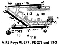
Runway Summary
| Runways: | 09L/27R 09R/27L 13/31 H1 |
| Longest Runway: | 09R/27L is 6000 ft (1829 m) long |
| Runways with an Instrument Approach: | 09R |
TMB Airport Runway Details
| Runway 09L/27R | 5003 ft x 150 ft (1525 m x 46 m) | |
| Runway Length Source: | NGS as of 02/07/2010 | |
| Surface: | Asphalt - Fair condition - Saw-cut or plastic grooved | |
| Runway Pavement Class: | 32 /F/A/Y/T | |
| Runway Edge Lights: | Medium Intensity | |
Runway Weight Bearing Capacity (in thousands of pounds) |
||
| Single Wheel Landing Gear: | 87.0 | |
| Dual Wheel Landing Gear: | 135.0 | |
| Dual Tandem Wheel Landing Gear: | 195.0 | |
Runway 09L |
Runway 27R |
|
Elevation: |
7.8 | 7.8 |
Latitude: |
25-39-09.4872N | 25-39-11.8051N |
Longitude: |
080-26-24.3015W | 080-25-29.6936W |
|
Runway True Alignment: |
087 | 267 |
Glide Path Angle: |
3.0 degrees | 3.0 degrees |
Traffic Pattern: |
Left | Right |
Runway Markings Type: |
Nonprecision Instrument | Nonprecision Instrument |
Runway Markings Condition: |
Fair | Fair |
Object at End: |
TOWER | |
Object Height: |
85 | |
Distance from End: |
4453 | |
Object Centerline Offset: |
100 ft. right of centerline | |
Visual Glide Slope Indicators: |
4-Light PAPI On Left Side Of Runway | 2-Light PAPI On Left Side Of Runway |
Threshold Crossing Height: |
53 | 40 |
| Runway 09R/27L | 6000 ft x 150 ft (1829 m x 46 m) | |
| Runway Length Source: | FAA as of 11/07/2014 | |
| Surface: | Asphalt - Fair condition - Saw-cut or plastic grooved | |
| Runway Pavement Class: | 32 /F/A/Y/T | |
| Runway Edge Lights: | High Intensity | |
Runway Weight Bearing Capacity (in thousands of pounds) |
||
| Single Wheel Landing Gear: | 87.0 | |
| Dual Wheel Landing Gear: | 135.0 | |
| Dual Tandem Wheel Landing Gear: | 195.0 | |
Runway 09R |
Runway 27L |
|
Elevation: |
10.0 | 7.9 |
Latitude: |
25-38-34.4430N | 25-38-37.2256N |
Longitude: |
080-26-27.9430W | 080-25-22.4640W |
|
Runway True Alignment: |
087 | 267 |
ILS Type: |
ILS | |
Glide Path Angle: |
3.0 degrees | 3.0 degrees |
Traffic Pattern: |
Right | Left |
Runway Markings Type: |
Precision Instrument | Precision Instrument |
Runway Markings Condition: |
Good | Good |
Object Centerline Offset: |
100 ft. right of centerline | |
Visual Glide Slope Indicators: |
4-Light PAPI On Right Side Of Runway | 4-Light PAPI On Left Side Of Runway |
Approach Light System: |
1,400 Foot Medium Intensity Approach Lighting System With Runway Alignment Indicator Lights | |
Threshold Crossing Height: |
55 | 53 |
| Runway 13/31 | 4001 ft x 150 ft (1220 m x 46 m) | |
| Runway Length Source: | NGS as of 02/07/2010 | |
| Surface: | Asphalt - Fair condition - Saw-cut or plastic grooved | |
| Runway Pavement Class: | 32 /F/A/Y/T | |
| Runway Edge Lights: | Medium Intensity | |
Runway Weight Bearing Capacity (in thousands of pounds) |
||
| Single Wheel Landing Gear: | 87.0 | |
| Dual Wheel Landing Gear: | 135.0 | |
| Dual Tandem Wheel Landing Gear: | 195.0 | |
Runway 13 |
Runway 31 |
|
Elevation: |
8.0 | 7.8 |
Latitude: |
25-39-02.0539N | 25-38-38.0122N |
Longitude: |
080-26-26.8558W | 080-25-52.1011W |
|
Runway True Alignment: |
127 | 307 |
Glide Path Angle: |
3.0 degrees | 0.0 degrees |
Traffic Pattern: |
Left | Left |
Runway Markings Type: |
Basic | Basic |
Runway Markings Condition: |
Fair | Fair |
Object at End: |
POLE | |
Object Height: |
29 | |
Distance from End: |
1215 | |
Object Centerline Offset: |
100 ft. right of centerline | |
Visual Glide Slope Indicators: |
4-Light PAPI On Left Side Of Runway | |
REIL: |
Yes | |
Threshold Crossing Height: |
40 |
| Helipad H1 | 75 ft x 75 ft (23 m x 23 m) | |
| Surface: | Asphalt - Fair condition - No special surface treatment | |
Helipad H1 |
||
Elevation: |
8.6 | |
Latitude: |
25-39-04.8160N | |
Longitude: |
080-25-12.5620W | |
Glide Path Angle: |
0.0 degrees | 0.0 degrees |
Object Centerline Offset: |
100 ft. right of centerline |
Services
Airframe Repair: |
Major |
Powerplant Repair: |
Major |
Bottled Oxygen: |
None |
Bulk Oxygen: |
None |
Fuel Available: |
100LL |
Landing Fees: |
Yes |
Parking: |
Hangars and tiedowns available |
Maps & Diagrams
TMB Sectional
Flight Planning
at skyvector.com
at skyvector.com