Location
Latitude: |
26-40-59.3820N (26.683162) |
Longitude: |
080-05-44.1310W (-80.095592) |
Elevation: |
19.6 feet MSL (6 m MSL) |
Magnetic Variation: |
7.4 W (as of April 2024 from WMM2020 model) |
Time Zone: |
UTC -5.0 (Standard Time) UTC -4.0 (Daylight Savings Time) |
From City: |
03 N.M. W of West Palm Beach, Florida |
Found On: |
Miami Chart |
FAA Region: |
ASO |
Contacts
Manager: |
Publicly owned: |
| LAURA BEEBE 846 PALM BEACH INTL AIRPORT WEST PALM BEACH, FL 33406 561-471-7420 |
PALM BEACH COUNTY 846 PALM BEACH INTL AIRPORT WEST PALM BEACH, FL 33406 561-471-7420 |
Operations
Airport Status: |
Operational |
Facility Use: |
Public |
Type: |
Airport |
Activation Date: |
04/1940 |
Control tower: |
Yes |
Attendance (Months/Days/Hours): |
Months/Days/Hours ALL/ALL/ALL |
Boundary ARTCC: |
ZMA (Miami) |
Responsible ARTCC: |
ZMA (Miami) |
Lighting Schedule: |
SS-SR |
Segmented Circle Indicator: |
No |
Traffic Pattern Altitude (MSL): |
1020 feet (311 m) |
NOTAMs Facility: |
PBI |
NOTAM-D Service: |
Yes |
International Airport of Entry: |
Yes |
Customs Landing Rights: |
No |
Military Landing Rights: |
Yes |
Civil/Military Joint Use: |
No |
Aircraft Rescue and Firefighting: |
Class I ARFF Index: C Air Carrier Service: Scheduled Certification Date: 05/1973 |
Based Aircraft
| Single Engine: | 6 |
| Multi Engine: | 8 |
| Jet Engine: | 171 |
| GA Helicopters: | 11 |
Annual Operations (as of 12/31/2021)
| Total Operations: | 162237 | |
| Commercial: | 46346 | 28.6% |
| Air Taxi: | 48446 | 29.9% |
| GA Local: | 119 | 0.1% |
| GA Itinerant: | 66692 | 41.1% |
| Military Aircraft: | 634 | 0.4% |
Communications
| Unicom: | 122.950 |
| Tower: | PALM BEACH 119.1 257.8 118.75 384.6 Hrs: 24 |
| Clearance Del.: | 121.6 284.6 |
| Ground: | 121.9 284.6 |
| Approach: | PALM BEACH 125.2 ;SOUTH 128.3 317.4 343.6 ;SOUTH Hrs: 24 |
| Departure: | PALM BEACH 125.2 ;SOUTH 128.3 317.4 343.6 ;SOUTH Hrs: 24 |
| ATIS: | 123.75 Hrs: 24 |
| ASOS: | 123.75 (561-683-2548) |
| MELBOURNE STAR: | 124.6 |
| WELLY DP: | 127.35 |
| JESTR STAR: | 317.4 |
| STOOP STAR: | 124.6 |
| CLASS C: | 128.3 ;NORTH |
| MELBOURNE STAR: | 317.4 |
| CLASS C: | 343.6 ;SOUTH |
| EMERG: | 121.5 |
| PALM BEACH DP: | 128.3 ;NORTH |
| OLAKE DP: | 317.4 |
| PALM BEACH DP: | 343.6 ;SOUTH |
| CLASS C: | 125.2 ;SOUTH |
| MIXAE DP: | 128.3 ;RWY 28R, 32 |
| CLASS C: | 317.4 ;NORTH |
| SLIDZ DP: | 317.4 |
| MAHHI STAR: | 343.6 |
| TTYLR STAR: | 125.2 |
| PALM BEACH DP: | 317.4 ;NORTH |
| STOOP STAR: | 317.4 |
| WELLY DP: | 343.6 |
| MIXAE DP: | 127.35 ;RWY 10L, 14 |
| OLAKE DP: | 128.3 |
| MIXAE DP: | 317.4 ;RWY 28R, 32 |
| TBIRD DP: | 317.4 |
| CLMNT STAR: | 124.6 |
| PALM BEACH DP: | 127.35 ;SOUTH |
| SLIDZ DP: | 128.3 |
| TTYLR STAR: | 317.4 |
| CPTAN STAR: | 124.6 |
| MAHHI STAR: | 127.35 |
| TBIRD DP: | 128.3 |
| CLMNT STAR: | 317.4 |
| VUUDU STAR: | 317.4 |
| JESTR STAR: | 124.6 |
| VUUDU STAR: | 127.35 |
| EMERG: | 243.0 |
| CPTAN STAR: | 317.4 |
| MIXAE DP: | 343.6 ;RWY 10L, 14 |
Fixed Based Operators (FBOs) & Fuel
(Click on a business for detail)
Please help us keep this information up to date. This is a FREE SERVICE just like everything else on Airport Guide! If you see that a business needs to be added, modified, or deleted please fill out our Update Form.
To add, modify, or delete a business click here.
Please help us keep this information up to date. This is a FREE SERVICE just like everything else on Airport Guide! If you see that a business needs to be added, modified, or deleted please fill out our Update Form.
Area Code: 561 |
| Business Name | Frequency | Phone | Fuel Grade |
|---|---|---|---|
| FlightSafety International
Website Update FBO info |
686-7677 | ||
| International Aviation Palm Beach, Inc.
Update FBO info |
Unicom 122.95 | 800-327-6222, 478-8700 | 100LL, Jet A |
| Jet Aviation Palm Beach
Update FBO info |
233-7242 | 100LL, Jet A | |
| Signature Flight Support
Website Update FBO info |
Unicom 122.95, Arinc 128.975 | +1 561 478 8700 | 100LL, Jet A |
Flight Service Stations
| Primary | Alternate | |
| FSS on Field: | N | |
| FSS Name (ID): | Miami(MIA) | |
| Frequency: | ||
| Toll Free Phone: | 1-800-WX-BRIEF |
Instrument Procedures / Charts
FAA Terminal Procedures valid from 0901Z 03/21/24 to 0901Z 04/18/24.
There are various types of charts available for an airport. They are listed in the Page Type column. Here is a legend for those types:
APD - Airport Diagram
DP - Departure Procedure Charts
HOT - Hot Spots
IAP - Instrument Approach Procedure Charts
MIN - Minimums
STAR - Standard Terminal Arrival Charts
Terminal Procedures are only available for airports in several countries with more being added all the time. If you are looking for a specific country's charts, please send an email to support(at)airportguide.com stating the country name. This will be used to prioritize the implementation.
Navigation Aids (Navaids) near PBI
| Dist (NM) | ID | Morse Code | Name | Type | Freq | True Hdg | Mag Hdg |
|---|---|---|---|---|---|---|---|
| 0.5 | PBI | . _ _ . _ . . . . . | Palm Beach | VOT | 109.00 | 298 | 305 |
| 0.5 | PBI | . _ _ . _ . . . . . | Palm Beach | VORTAC | 115.70 | 110 | 117 |
| 18.7 | UTX | . . _ _ _ . . _ | United | NDB | 405 | 316 | 323 |
| 31.8 | FX | . . _ . _ . . _ | Praiz | NDB | 221 | 200 | 207 |
| 32.5 | PHK | . _ _ . . . . . _ . _ | Pahokee | VOR-DME | 115.40 | 280 | 287 |
| 36.8 | FLL | . . _ . . _ . . . _ . . | Fort Lauderdale | VOR-DME | 114.40 | 185 | 192 |
| 50.4 | FPR | . . _ . . _ _ . . _ . | Fort Pierce | NDB | 275 | 342 | 349 |
| 54.2 | MIA | _ _ . . . _ | Miami Intl | VOT | 112.00 | 190 | 197 |
| 54.7 | DHP | _ . . . . . . . _ _ . | Dolphin | VORTAC | 113.90 | 194 | 201 |
| 56.0 | VKZ | . . . _ _ . _ _ _ . . | Virginia Key | VOR-DME | 117.10 | 183 | 190 |
| 63.3 | TRV | _ . _ . . . . _ | Treasure | VORTAC | 117.30 | 340 | 347 |
| 66.3 | TM | _ _ _ | Qeezy | NDB | 266 | 199 | 206 |
| 69.7 | TN | _ _ . | Monry | NDB | 227 | 225 | 232 |
| 70.0 | LBV | . _ . . _ . . . . . . _ | La Belle | VORTAC | 110.40 | 277 | 284 |
| 71.5 | ZFP | _ _ . . . . _ . . _ _ . | Freeport | NDB | 209 | 97 | 105 |
| 72.9 | ZBV | _ _ . . _ . . . . . . _ | Bimini | VORTAC | 116.70 | 143 | 151 |
| 73.2 | HST | . . . . . . . _ | Homestead | TACAN | 108.20 | 192 | 199 |
| 75.4 | ZFP | _ _ . . . . _ . . _ _ . | Freeport | VOR-DME | 113.20 | 95 | 103 |
| 77.1 | BHF | Islands | NDB | 326 | 94 | 102 | |
| 90.0 | MLB | _ _ . _ . . _ . . . | Melbourne | VOR-DME | 115.85 | 341 | 348 |
Nearby Airports with Fuel
Notices to Airmen (NOTAMS)
Remarks
| A110-1 | MIGRATORY BIRDS ON AND INVOF ARPT. |
| A110-10 | BE ALERT: TWY L IS LCTD BTWN RYS 10L/28R & 10R/28L. TWY L IS WIDER AND LONGER THAN RY 10R/28L - DO NOT CONFUSE TWY L FOR RY. AIRCRAFT WITH WINGSPAN OF 118 FT OR GREATER IS PROHIBITED ON TWY L. |
| A110-13 | 24 HR PPR FOR ACFT WITH WINGSPANS GTR THAN 171 FT. |
| A110-14 | ACFT WITH WINGSPANS GTR THAN 118 FT MAY NOT OPR ON TWY E, TWY W, TWY Y AND TWY F NW OF TWY A. |
| A110-15 | RWY 14/32 SAFETY AREA NOT STD SFC VARNS. |
| A110-16 | RWY 10L/28R SAFETY AREA NOT STD SFC VARNS. |
| A110-17 | ACFT WITH WINGSPANS GTR THAN 49 MAY NOT OPER SIMUL ON RWY 10R/28L AND TWY R. |
| A110-18 | RWY 10L/28R SAFETY AREA NOT STD SFC VARNS. |
| A110-2 | NOISE ABATEMENT PROCEDURES IN EFFECT. MULTIENGINE FLIGHT TRAINING PROHIBITED SS TO SR SUN AND HOLIDAY; STRICT ENVIRONMENTAL OPERATING STAGE 2 ACFT 0300-1200Z CALL NOISE ABATEMENT OFFICER 561-471-7467. |
| A110-5 | BE ALERT; RYS 28L & 28R THLDS STAGGERED BY 5400 FT. |
| A110-6 | RWY 10R/28L NOT AVBL FOR SKED ACR OPS WITH MORE THAN 9 PAX SEATS OR UNSKED ACR AT LEAST 31 PAX SEATS. |
| A26 | INDEX D ARFF EQUIPMENT AVAILABLE; 24 HOUR PPR. |
| A30-14/32 | ARRESTING GEAR/SYSTEM: ENGINEERED MATERIALS ARRESTING SYSTEM (EMAS) 222 FT IN LENGTH BY 170 FT IN WIDTH AT THE DEPARTURE END OF RWY 14. |
| A57-10L | RWY 10L & RWY 28R APCH RATIO 50:1 AT DISPLACEMENT. |
| A57-32 | APCH RATIO 36:1 FM DSPLCD THR; TREES 965 FT OUT & 385 FT L. |
| A58-32 | ROAD 200 FT FM AER RWY 32, 250 FT LEFT OF CNTRLN. |
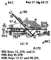
Runways
Runway Summary
| Runways: | 10L/28R 10R/28L 14/32 |
| Longest Runway: | 10L/28R is 10001 ft (3048 m) long |
| Runways with an Instrument Approach: | 10L, 28R |
PBI Airport Runway Details
| Runway 10L/28R | 10001 ft x 150 ft (3048 m x 46 m) | |
| Runway Length Source: | 3RD PARTY SURVEY as of 03/17/2015 | |
| Surface: | Asphalt - Good condition - Saw-cut or plastic grooved | |
| Runway Pavement Class: | 93 /F/B/W/T | |
| Runway Edge Lights: | High Intensity | |
Runway Weight Bearing Capacity (in thousands of pounds) |
||
| Single Wheel Landing Gear: | 120.0 | |
| Dual Wheel Landing Gear: | 175.0 | |
| Dual Tandem Wheel Landing Gear: | 550.0 | |
| Dual Dual Tandem Wheel Landing Gear: | 840.0 | |
Runway 10L |
Runway 28R |
|
Elevation: |
19.6 | 16.4 |
Latitude: |
26-40-59.5493N | 26-40-54.7438N |
Longitude: |
080-06-30.1296W | 080-04-40.0137W |
|
Runway True Alignment: |
093 | 273 |
ILS Type: |
ILS/DME | LOC/GS |
Glide Path Angle: |
3.0 degrees | 3.0 degrees |
Traffic Pattern: |
Left | Left |
Runway Markings Type: |
Precision Instrument | Precision Instrument |
Runway Markings Condition: |
Good | Good |
Object at End: |
TREES | TREES |
Object Height: |
41 | 40 |
Distance from End: |
1665 | 2230 |
Object Centerline Offset: |
515 ft. left of centerline | 670 ft. left of centerline |
Visual Glide Slope Indicators: |
4-Light PAPI On Right Side Of Runway | 4-Light PAPI On Left Side Of Runway |
Runway Visual Range (RVR): |
Touchdown, Rollout | Touchdown, Rollout |
Approach Light System: |
1,400 Foot Medium Intensity Approach Lighting System With Runway Alignment Indicator Lights | |
REIL: |
Yes | |
Centerline Lights: |
Yes | Yes |
Threshold Crossing Height: |
68 | 70 |
Threshold Elevation: |
16.0 | 18.3 |
Displaced Threshold: |
1200 | 811 |
Threshold Latitude: |
26-40-58.9743N | 26-40-55.1329N |
Threshold Longitude: |
080-06-16.9162W | 080-04-48.9431W |
Declared Distances |
||
Take Off Run Avbl. (TORA): |
10001 | 10001 |
Take Off Distance Avbl. (TODA): |
10001 | 10001 |
Actual Stop Dist. Avbl. (ASDA): |
9351 | 9051 |
Landing Dist. Avbl. (LDA): |
8151 | 8240 |
| Runway 10R/28L | 3214 ft x 75 ft (980 m x 23 m) | |
| Runway Length Source: | 3RD PARTY SURVEY as of 03/17/2015 | |
| Surface: | Asphalt - Good condition - No special surface treatment | |
| Runway Pavement Class: | 44 /F/A/X/T | |
| Runway Edge Lights: | Medium Intensity | |
Runway Weight Bearing Capacity (in thousands of pounds) |
||
| Single Wheel Landing Gear: | 25.0 | |
Runway 10R |
Runway 28L |
|
Elevation: |
17.1 | 13.6 |
Latitude: |
26-40-52.2820N | 26-40-50.7327N |
Longitude: |
080-06-22.6416W | 080-05-47.2501W |
|
Runway True Alignment: |
093 | 273 |
Glide Path Angle: |
0.0 degrees | 0.0 degrees |
Traffic Pattern: |
Right | Left |
Runway Markings Type: |
Basic | Basic |
Runway Markings Condition: |
Good | Good |
Object at End: |
TREES | |
Object Height: |
30 | |
Distance from End: |
1416 | |
Object Centerline Offset: |
515 ft. left of centerline | 670 ft. left of centerline |
REIL: |
Yes | Yes |
Declared Distances |
||
Take Off Run Avbl. (TORA): |
3214 | 3214 |
Take Off Distance Avbl. (TODA): |
3214 | 3214 |
Actual Stop Dist. Avbl. (ASDA): |
3214 | 3214 |
Landing Dist. Avbl. (LDA): |
3214 | 3214 |
| Runway 14/32 | 6931 ft x 150 ft (2113 m x 46 m) | |
| Runway Length Source: | 3RD PARTY SURVEY as of 03/17/2015 | |
| Surface: | Asphalt - Good condition - Saw-cut or plastic grooved | |
| Runway Pavement Class: | 67 /F/A/W/T | |
| Runway Edge Lights: | Medium Intensity | |
Runway Weight Bearing Capacity (in thousands of pounds) |
||
| Single Wheel Landing Gear: | 100.0 | |
| Dual Wheel Landing Gear: | 180.0 | |
| Dual Tandem Wheel Landing Gear: | 325.0 | |
| Dual Dual Tandem Wheel Landing Gear: | 400.0 | |
Runway 14 |
Runway 32 |
|
Elevation: |
17.0 | 15.8 |
Latitude: |
26-41-30.5960N | 26-40-41.9130N |
Longitude: |
080-06-14.4820W | 080-05-20.6220W |
|
Runway True Alignment: |
135 | 315 |
Glide Path Angle: |
3.0 degrees | 3.2 degrees |
Traffic Pattern: |
Left | Left |
Runway Markings Type: |
Nonprecision Instrument | Nonprecision Instrument |
Runway Markings Condition: |
Good | Good |
Arresting Device: |
EMAS | |
Object at End: |
TREES | ROAD |
Object Height: |
34 | 17 |
Distance from End: |
1370 | 200 |
Object Centerline Offset: |
515 ft. left of centerline | 670 ft. left of centerline |
Visual Glide Slope Indicators: |
4-Light PAPI On Right Side Of Runway | 4-Light PAPI On Left Side Of Runway |
REIL: |
Yes | Yes |
Centerline Lights: |
No | No |
Threshold Crossing Height: |
66 | 57 |
Threshold Elevation: |
15.7 | |
Displaced Threshold: |
418 | |
Threshold Latitude: |
26-40-44.8490N | |
Threshold Longitude: |
080-05-23.8710W | |
Declared Distances |
||
Take Off Run Avbl. (TORA): |
6926 | 6926 |
Take Off Distance Avbl. (TODA): |
6926 | 6926 |
Actual Stop Dist. Avbl. (ASDA): |
6000 | 6926 |
Landing Dist. Avbl. (LDA): |
6000 | 6513 |
Services
Airframe Repair: |
Minor |
Powerplant Repair: |
Major |
Bottled Oxygen: |
None |
Bulk Oxygen: |
None |
Fuel Available: |
100LL, Jet A |
Landing Fees: |
No |
Parking: |
Tiedowns available |
Maps & Diagrams
PBI Sectional
Flight Planning
at skyvector.com
at skyvector.com