
Location
Latitude: |
27-58-31.7000N (27.975472) |
Longitude: |
082-31-59.7000W (-82.53325) |
Elevation: |
26.4 feet MSL (8 m MSL) |
Magnetic Variation: |
6 W (as of April 2024 from WMM2020 model) |
Time Zone: |
UTC -5.0 (Standard Time) UTC -4.0 (Daylight Savings Time) |
From City: |
06 N.M. W of Tampa, Florida |
Found On: |
Miami Chart |
FAA Region: |
ASO |
Contacts
Manager: |
Publicly owned: |
| JOHN TILIACOS PO BOX 22287 TAMPA, FL 33622 813-870-8700 |
HILLSBOROUGH CO AVN AUTHORITY PO BOX 22287 TAMPA, FL 33622 813-870-8700 |
Operations
Airport Status: |
Operational |
Facility Use: |
Public |
Type: |
Airport |
Activation Date: |
04/1940 |
Control tower: |
Yes |
Attendance (Months/Days/Hours): |
Months/Days/Hours ALL/ALL/ALL |
Boundary ARTCC: |
ZJX (Jacksonville) |
Responsible ARTCC: |
ZMA (Miami) |
Lighting Schedule: |
SS-SR |
Segmented Circle Indicator: |
Yes |
Traffic Pattern Altitude (MSL): |
1026 feet (313 m) |
NOTAMs Facility: |
TPA |
NOTAM-D Service: |
Yes |
International Airport of Entry: |
Yes |
Customs Landing Rights: |
No |
Military Landing Rights: |
Yes |
Civil/Military Joint Use: |
No |
Aircraft Rescue and Firefighting: |
Class I ARFF Index: D Air Carrier Service: Scheduled Certification Date: 05/1973 |
Based Aircraft
| Single Engine: | 13 |
| Multi Engine: | 5 |
| Jet Engine: | 52 |
| GA Helicopters: | 6 |
Annual Operations (as of 04/30/2023)
| Total Operations: | 216504 | |
| Commercial: | 166433 | 76.9% |
| Air Taxi: | 21137 | 9.8% |
| GA Itinerant: | 28163 | 13.0% |
| Military Aircraft: | 771 | 0.4% |
Communications
| Unicom: | 122.950 |
| Tower: | TAMPA 119.5 269.4 119.05 Hrs: 24 |
| Clearance Del.: | 133.6 |
| Ground: | 121.7 269.4 |
| Approach: | TAMPA 118.15 ;001-150 118.5 239.3 ;220-360 279.6 ;001-150 307.175 353.575 ;151-219 Hrs: 24 353.75 |
| Departure: | TAMPA 118.15 ;001-150 118.5 239.3 ;220-360 279.6 ;001-150 307.175 353.575 ;151-219 Hrs: 24 353.75 |
| ATIS: | 126.45 ;ARR 128.475 ;DEP Hrs: 24 |
| ASOS: | 126.45 (813-873-7228) |
| RAYZZ STAR: | 118.8 |
| EMERG: | 121.5 |
| DADES STAR: | 135.5 |
| EMERG: | 243.0 |
| CLASS B: | 316.05 ;220-360 |
| CLASS B: | 125.3 ;220-360 |
| BAYPO DP: | 239.3 |
| CLASS B: | 353.575 ;151-219 |
| BAYPO DP: | 118.8 |
| CLASS B: | 119.65 ;151-219 |
| DORMR DP: | 239.3 |
| BLFRG STAR: | 353.575 |
| DORMR DP: | 118.8 |
| BLFRG STAR: | 119.65 |
| ENDED DP: | 239.3 |
| CROWD DP: | 279.6 |
| BRDGE STAR: | 353.575 |
| ENDED DP: | 118.8 |
| BRDGE STAR: | 119.65 |
| KNOST DP: | 239.3 |
| DADES STAR: | 279.6 |
| GANDY DP: | 353.575 |
| KNOST DP: | 118.8 |
| GANDY DP: | 119.65 |
| LGTNG DP: | 239.3 |
| TAMPA DP: | 279.6 |
| LGTNG DP: | 118.8 |
| CLASS B: | 119.9 ;001-150 |
| TAMPA DP: | 134.25 |
| MAATY STAR: | 239.3 |
| CLASS B: | 290.3 ;001-150 |
| MAATY STAR: | 118.8 |
| CROWD DP: | 135.5 |
| RAYZZ STAR: | 239.3 |
- TA31 ASR-6 REMOTED AT SARASOTA-BRADENTON ARPT.
Fixed Based Operators (FBOs) & Fuel
(Click on a business for detail)
Please help us keep this information up to date. This is a FREE SERVICE just like everything else on Airport Guide! If you see that a business needs to be added, modified, or deleted please fill out our Update Form.
To add, modify, or delete a business click here.
Please help us keep this information up to date. This is a FREE SERVICE just like everything else on Airport Guide! If you see that a business needs to be added, modified, or deleted please fill out our Update Form.
Area Code: 813 |
| Business Name | Frequency | Phone | Fuel Grade |
|---|---|---|---|
| Gulf Coast Avionics, Corp.
Update FBO info |
879-9714 | ||
| Raytheon Aircraft Services
Update FBO info |
878-4500 | 100LL, Jet A | |
| Signature Flight Support
Update FBO info |
Arinc: 130 | +1 813 870 3813 |
Flight Service Stations
| Primary | Alternate | |
| FSS on Field: | N | |
| FSS Name (ID): | Saint Petersburg(PIE) | |
| Frequency: | ||
| Toll Free Phone: | 1-800-WX-BRIEF |
Instrument Procedures / Charts
FAA Terminal Procedures valid from 0901Z 03/21/24 to 0901Z 04/18/24.
There are various types of charts available for an airport. They are listed in the Page Type column. Here is a legend for those types:
APD - Airport Diagram
DP - Departure Procedure Charts
HOT - Hot Spots
IAP - Instrument Approach Procedure Charts
MIN - Minimums
STAR - Standard Terminal Arrival Charts
Terminal Procedures are only available for airports in several countries with more being added all the time. If you are looking for a specific country's charts, please send an email to support(at)airportguide.com stating the country name. This will be used to prioritize the implementation.
Navigation Aids (Navaids) near TPA
| Dist (NM) | ID | Morse Code | Name | Type | Freq | True Hdg | Mag Hdg |
|---|---|---|---|---|---|---|---|
| 0.1 | TPA | _ . _ _ . . _ | Tampa Intl | VOT | 111.00 | 155 | 161 |
| 6.6 | TP | _ . _ _ . | Cosme | NDB | 368 | 3 | 9 |
| 6.9 | AM | . _ _ _ | Picny | NDB | 388 | 185 | 191 |
| 6.9 | MCF | _ _ _ . _ . . . _ . | Macdill | TACAN | 111.00 | 171 | 177 |
| 9.0 | PIE | . _ _ . . . . | St Petersburg | VORTAC | 116.40 | 243 | 249 |
| 9.1 | PI | . _ _ . . . | Capok | NDB | 360 | 277 | 283 |
| 25.0 | RHZ | . _ . . . . . _ _ . . | Zephyrhills | NDB | 253 | 52 | 58 |
| 27.5 | LAL | . _ . . . _ . _ . . | Lakeland | VORTAC | 116.00 | 88 | 94 |
| 34.1 | SRQ | . . . . _ . _ _ . _ | Sarasota | VOR-DME | 117.00 | 182 | 188 |
| 55.1 | VNC | . . . _ _ . _ . _ . | Venice | NDB | 206 | 174 | 180 |
| 63.4 | LEE | . _ . . . . | Leesburg | NDB | 335 | 36 | 42 |
| 66.3 | OR | _ _ _ . _ . | Herny | NDB | 221 | 60 | 66 |
| 69.8 | PGD | . _ _ . _ _ . _ . . | Punta Gorda | VOR | 110.20 | 155 | 161 |
| 71.9 | ORL | _ _ _ . _ . . _ . . | Orlando | VORTAC | 112.20 | 61 | 67 |
| 73.9 | OCF | _ _ _ _ . _ . . . _ . | Ocala | VORTAC | 113.70 | 12 | 18 |
| 83.6 | SFB | . . . . . _ . _ . . . | Sanford | NDB | 408 | 54 | 60 |
| 91.9 | LBV | . _ . . _ . . . . . . _ | La Belle | VORTAC | 110.40 | 138 | 144 |
| 92.9 | FM | . . _ . _ _ | Caloo | NDB | 341 | 160 | 166 |
| 93.3 | DED | _ . . . _ . . | Deland/Dcmsnd | NDB | 201 | 45 | 51 |
| 95.7 | RSW | . _ . . . . . _ _ | Lee County | VORTAC | 114.15 | 154 | 160 |
Nearby Airports with Fuel
Notices to Airmen (NOTAMS)
Remarks
| A110-10 | RSTRS TO ADG IV OR LGR: TWY E1. |
| A110-2 | RWY 19L IS NOISE SENSITIVE TO TBJT DEPARTURES. RWY 01R IS NOISE SENSITIVE TO TBJT ARRIVALS. PUBLD NOISE ABATEMENT PROCS IN EFCT. |
| A110-3 | ONLY ACFT WITH PRIOR PMSN MAY USE TRML APN; ALL OTRS USE GA APN. |
| A110-4 | BIRD ACT ON AND INVOF ARPT. |
| A110-7 | RSTRS TO DESIGN GROUP V OR LGR; TWY J BTN TWY J1 AND TWY J2; TWY N WEST OF TWY L AND TWY E NORTH OF TWY J UNAVBL; TAXILANE Z CLSD TO WINGSPAN GTR THAN 171 FT - PPR ARPT OPS. |
| A110-8 | TWY F AND TWY R ARE NON-MOVEMENT AREAS. BOTH LOCATONS ARE UNAVBL FOR GROUP IV ACFT WITH A WINGSPAN GTR THAN 117 FT WO PPR FM ARPT OPS. TWY T PPR FROM ARPT OPS RQRD FOR ACFT WITH A WINGSPAN GTR THAN 90 FT. |
| A110-9 | TAXILANE G WEST OF TWY B1 CLSD TO WINGSPAN GTR THAN 118 FT - PPR APT OPS. |
| A16 | 813-870-8752 |
| A30-10/28 | NOT NMLY AVBL TO OPNS OVER 75,000 LBS GWT. |
| A33-10/28 | RWY 10 FIRST 2600 FT CONC; RWY 28 FIRST 4400 FT ASPH. |
| A43-10 | RWY 10 PAPI UNUSBL 8 DEG LEFT AND RIGHT OF RCL. |
| A57-10 | RWY 10 APCH SFC IS 50:1 TO MKD DSPLCD THR. |
Runways
Runway Summary
| Runways: | 01L/19R 01R/19L 10/28 |
| Longest Runway: | 01L/19R is 11002 ft (3353 m) long |
| Runways with an Instrument Approach: | 01L, 19R, 01R, 19L |
TPA Airport Runway Details
| Runway 01L/19R | 11002 ft x 150 ft (3353 m x 46 m) | |
| Runway Length Source: | 3RD PARTY SURVEY as of 11/23/2013 | |
| Surface: | Concrete - Good condition - Saw-cut or plastic grooved | |
| Runway Pavement Class: | 85 /R/B/W/T | |
| Runway Edge Lights: | High Intensity | |
Runway Weight Bearing Capacity (in thousands of pounds) |
||
| Single Wheel Landing Gear: | 60.0 | |
| Dual Wheel Landing Gear: | 210.0 | |
| Dual Tandem Wheel Landing Gear: | 358.0 | |
| Dual Dual Tandem Wheel Landing Gear: | 850.0 | |
Runway 01L |
Runway 19R |
|
Elevation: |
10.7 | 21.0 |
Latitude: |
27-57-47.8596N | 27-59-36.7423N |
Longitude: |
082-32-32.4793W | 082-32-28.7801W |
|
Runway True Alignment: |
002 | 182 |
ILS Type: |
ILS/DME | ILS/DME |
Glide Path Angle: |
3.0 degrees | 3.0 degrees |
Traffic Pattern: |
Left | Left |
Runway Markings Type: |
Precision Instrument | Precision Instrument |
Runway Markings Condition: |
Good | Good |
Object at End: |
ROAD | |
Object Height: |
15 | |
Distance from End: |
955 | |
Object Centerline Offset: |
500 ft. right of centerline | |
Visual Glide Slope Indicators: |
4-Light PAPI On Left Side Of Runway | 4-Light PAPI On Left Side Of Runway |
Runway Visual Range (RVR): |
Touchdown, Midfield, Rollout | Touchdown, Midfield, Rollout |
Approach Light System: |
Standard 2,400 Foot High Intensity Approach Lighting System With Sequenced Flashers, Cat. II or III Config. | 1,400 Foot Medium Intensity Approach Lighting System With Runway Alignment Indicator Lights |
REIL: |
No | No |
Touchdown Lights: |
Yes | No |
Centerline Lights: |
Yes | Yes |
Threshold Crossing Height: |
71 | 71 |
Declared Distances |
||
Take Off Run Avbl. (TORA): |
11002 | 11002 |
Take Off Distance Avbl. (TODA): |
11002 | 11002 |
Actual Stop Dist. Avbl. (ASDA): |
10800 | 11002 |
Landing Dist. Avbl. (LDA): |
10800 | 11002 |
| Runway 01R/19L | 8300 ft x 150 ft (2530 m x 46 m) | |
| Runway Length Source: | 3RD PARTY SURVEY as of 11/23/2013 | |
| Surface: | Concrete - Good condition - Saw-cut or plastic grooved | |
| Runway Pavement Class: | 76 /R/B/W/T | |
| Runway Edge Lights: | High Intensity | |
Runway Weight Bearing Capacity (in thousands of pounds) |
||
| Single Wheel Landing Gear: | 60.0 | |
| Dual Wheel Landing Gear: | 210.0 | |
| Dual Tandem Wheel Landing Gear: | 358.0 | |
| Dual Dual Tandem Wheel Landing Gear: | 850.0 | |
Runway 01R |
Runway 19L |
|
Elevation: |
17.7 | 26.0 |
Latitude: |
27-57-51.5169N | 27-59-13.6607N |
Longitude: |
082-31-44.3687W | 082-31-41.5739W |
|
Runway True Alignment: |
002 | 182 |
ILS Type: |
LOC/DME | ILS/DME |
Glide Path Angle: |
3.0 degrees | 3.0 degrees |
Traffic Pattern: |
Left | Left |
Runway Markings Type: |
Precision Instrument | Precision Instrument |
Runway Markings Condition: |
Good | Good |
Object Centerline Offset: |
500 ft. right of centerline | |
Visual Glide Slope Indicators: |
4-Light PAPI On Left Side Of Runway | 4-Light PAPI On Left Side Of Runway |
Runway Visual Range (RVR): |
Touchdown, Midfield, Rollout | Touchdown, Midfield, Rollout |
Approach Light System: |
Standard 2,400 Foot High Intensity Approach Lighting System With Sequenced Flashers, Cat. II or III Config. | |
REIL: |
Yes | No |
Touchdown Lights: |
No | Yes |
Centerline Lights: |
Yes | Yes |
Threshold Crossing Height: |
71 | 61 |
Declared Distances |
||
Take Off Run Avbl. (TORA): |
8300 | 8300 |
Take Off Distance Avbl. (TODA): |
8300 | 8300 |
Actual Stop Dist. Avbl. (ASDA): |
8300 | 8300 |
Landing Dist. Avbl. (LDA): |
8300 | 8300 |
| Runway 10/28 | 6999 ft x 150 ft (2133 m x 46 m) | |
| Runway Length Source: | 3RD PARTY SURVEY as of 09/28/2016 | |
| Surface: | Concrete - Good condition - Saw-cut or plastic grooved | |
| Runway Pavement Class: | 61 /F/A/W/T | |
| Runway Edge Lights: | High Intensity | |
Runway Weight Bearing Capacity (in thousands of pounds) |
||
| Single Wheel Landing Gear: | 75.0 | |
| Dual Wheel Landing Gear: | 200.0 | |
| Dual Tandem Wheel Landing Gear: | 280.0 | |
| Dual Dual Tandem Wheel Landing Gear: | 380.0 | |
Runway 10 |
Runway 28 |
|
Elevation: |
14.5 | 26.4 |
Latitude: |
27-58-14.9917N | 27-58-12.8902N |
Longitude: |
082-32-09.9027W | 082-30-51.8781W |
|
Runway True Alignment: |
092 | 272 |
Glide Path Angle: |
3.0 degrees | 3.0 degrees |
Traffic Pattern: |
Left | Left |
Runway Markings Type: |
Nonprecision Instrument | Nonprecision Instrument |
Runway Markings Condition: |
Good | Good |
Object at End: |
RR | TREES |
Object Height: |
18 | 41 |
Distance from End: |
755 | 1660 |
Object Centerline Offset: |
500 ft. right of centerline | |
Visual Glide Slope Indicators: |
4-Light PAPI On Left Side Of Runway | 4-Light PAPI On Left Side Of Runway |
REIL: |
No | No |
Threshold Crossing Height: |
42 | 50 |
Threshold Elevation: |
14.5 | |
Displaced Threshold: |
498 | |
Threshold Latitude: |
27-58-14.8428N | |
Threshold Longitude: |
082-32-04.3499W | |
Declared Distances |
||
Take Off Run Avbl. (TORA): |
6999 | 6999 |
Take Off Distance Avbl. (TODA): |
6999 | 6999 |
Actual Stop Dist. Avbl. (ASDA): |
6999 | 6501 |
Landing Dist. Avbl. (LDA): |
6501 | 6501 |
Services
Airframe Repair: |
None |
Powerplant Repair: |
None |
Bottled Oxygen: |
None |
Bulk Oxygen: |
None |
Fuel Available: |
100LL |
Landing Fees: |
No |
Parking: |
Tiedowns available |
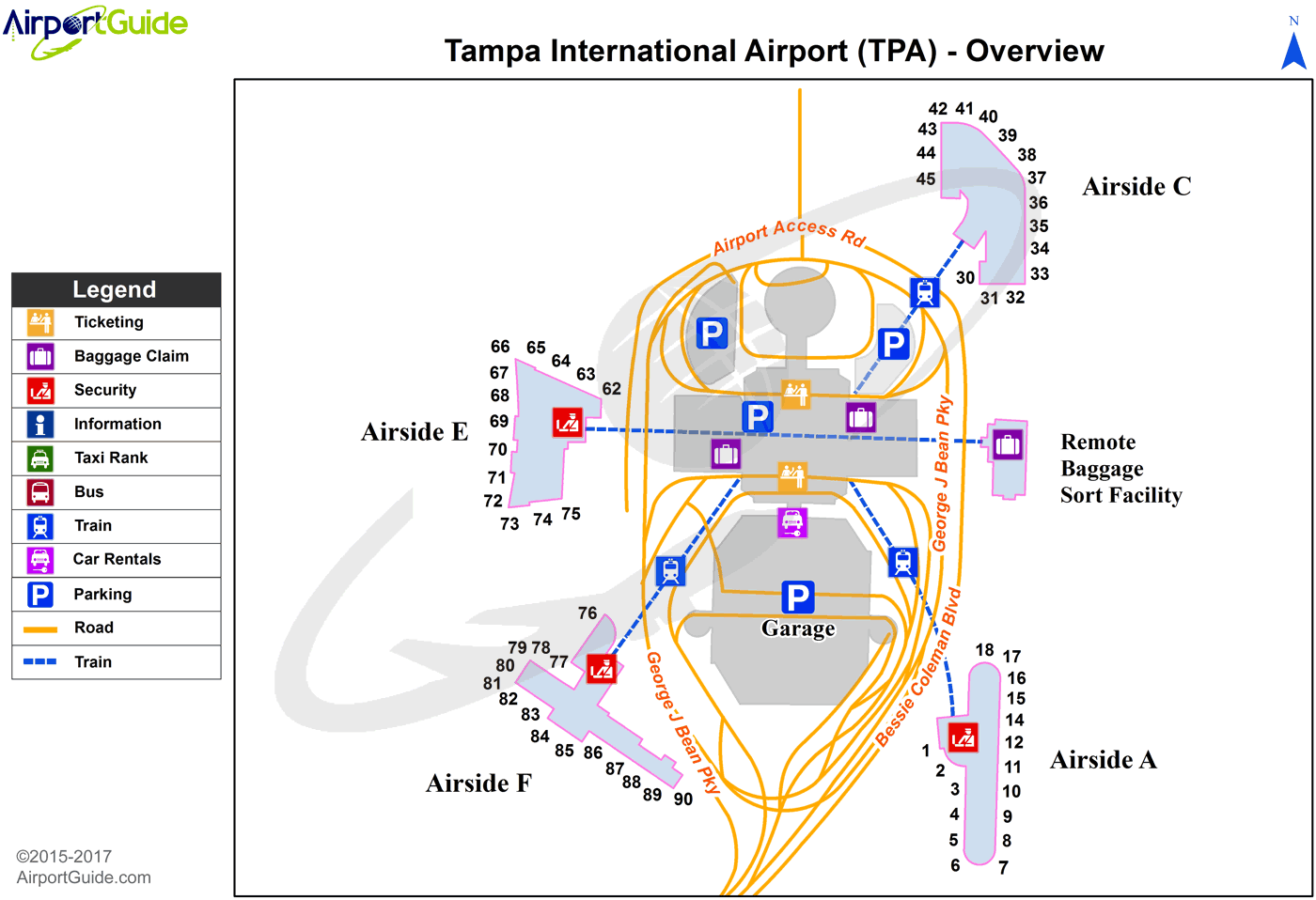
Maps & Diagrams
TPA Sectional
Flight Planning
at skyvector.com
at skyvector.com
