Location
Latitude: |
27-59-15.5000N (27.987639) |
Longitude: |
082-01-08.4000W (-82.019) |
Elevation: |
141.8 feet MSL (43 m MSL) |
Magnetic Variation: |
6.4 W (as of April 2024 from WMM2020 model) |
Time Zone: |
UTC -5.0 (Standard Time) UTC -4.0 (Daylight Savings Time) |
From City: |
04 N.M. SW of Lakeland, Florida |
Found On: |
Miami Chart |
FAA Region: |
ASO |
Contacts
Manager: |
Publicly owned: |
| KRIS HALLSTRAND 3900 DON EMERSON DRIVE SUITE 210 LAKELAND, FL 33811-1340 863-834-3298 |
CITY OF LAKELAND 3900 DON EMERSON DRIVE SUITE 210 LAKELAND, FL 33811-1340 863-834-3298 |
Operations
Airport Status: |
Operational |
Facility Use: |
Public |
Type: |
Airport |
Activation Date: |
01/1943 |
Control tower: |
Yes |
Attendance (Months/Days/Hours): |
Months/Days/Hours ALL/ALL/ALL |
Boundary ARTCC: |
ZMA (Miami) |
Responsible ARTCC: |
ZMA (Miami) |
Segmented Circle Indicator: |
Yes |
Traffic Pattern Altitude (MSL): |
1142 feet (348 m) |
NOTAMs Facility: |
LAL |
NOTAM-D Service: |
Yes |
International Airport of Entry: |
No |
Customs Landing Rights: |
No |
Military Landing Rights: |
Yes |
Civil/Military Joint Use: |
No |
Aircraft Rescue and Firefighting: |
Class I ARFF Index: A Air Carrier Service: Not Scheduled Certification Date: 12/1977 |
Based Aircraft
| Single Engine: | 227 |
| Multi Engine: | 40 |
| Jet Engine: | 48 |
| GA Helicopters: | 4 |
| Gliders: | 3 |
Annual Operations (as of 12/31/2021)
| Total Operations: | 156788 | |
| Commercial: | 14113 | 9.0% |
| Air Taxi: | 2460 | 1.6% |
| GA Local: | 66365 | 42.3% |
| GA Itinerant: | 72164 | 46.0% |
| Military Aircraft: | 1686 | 1.1% |
Communications
| Unicom: | 122.950 |
| Tower: | LAKELAND 124.5 236.775 Hrs: 24 |
| Ground: | 121.4 |
| Approach: | TAMPA |
| Departure: | TAMPA |
| ATIS: | 118.025 Hrs: 24 |
| AWOS-3PT: | (863-834-2030) |
| EMERG: | 121.5 |
Fixed Based Operators (FBOs) & Fuel
(Click on a business for detail)
Please help us keep this information up to date. This is a FREE SERVICE just like everything else on Airport Guide! If you see that a business needs to be added, modified, or deleted please fill out our Update Form.
To add, modify, or delete a business click here.
Please help us keep this information up to date. This is a FREE SERVICE just like everything else on Airport Guide! If you see that a business needs to be added, modified, or deleted please fill out our Update Form.
Area Code: 863 |
| Business Name | Frequency | Phone | Fuel Grade |
|---|---|---|---|
| Aeromech, Inc.
Website Update FBO info |
888-618-8133, 619-8133 | ||
| Cypress Aviation
Website Update FBO info |
644-0428, 888-242-9537 | ||
| FlightSafety International
Website Update FBO info |
646-5037, 800-726-5037 | ||
| Piedmont Hawthorne Aviation
Website Update FBO info |
Unicom 122.95 | 644-0433 | 100LL, Jet A |
| S & S Aircraft
Update FBO info |
648-0677 | ||
| The Academy, Inc.
Website Update FBO info |
Unicom 121.95 | 800-532-3210, 648-2004 |
Flight Service Stations
| Primary | Alternate | |
| FSS on Field: | N | |
| FSS Name (ID): | Saint Petersburg(PIE) | |
| Frequency: | ||
| Toll Free Phone: | 1-800-WX-BRIEF |
Instrument Procedures / Charts
FAA Terminal Procedures valid from 0901Z 03/21/24 to 0901Z 04/18/24.
There are various types of charts available for an airport. They are listed in the Page Type column. Here is a legend for those types:
APD - Airport Diagram
DP - Departure Procedure Charts
HOT - Hot Spots
IAP - Instrument Approach Procedure Charts
MIN - Minimums
STAR - Standard Terminal Arrival Charts
| Page Type | Page Name | Volume | Action Since Last Cycle |
|---|---|---|---|
| APD | AIRPORT DIAGRAM | SE-3 | |
| IAP | ILS OR LOC RWY 10 | SE-3 | |
| IAP | ILS RWY 10 (CAT II - III) | SE-3 | |
| IAP | ILS RWY 10 (SA CAT I) | SE-3 | |
| IAP | RNAV (GPS) RWY 05 | SE-3 | |
| IAP | RNAV (GPS) RWY 10 | SE-3 | |
| IAP | RNAV (GPS) RWY 23 | SE-3 | |
| IAP | RNAV (GPS) RWY 28 | SE-3 | |
| IAP | VOR RWY 10 | SE-3 | |
| IAP | VOR RWY 28 | SE-3 | |
| LAH | LAHSO | SE-3 | |
| MIN | ALTERNATE MINIMUMS | SE-3 | |
| MIN | TAKEOFF MINIMUMS | SE-3 | |
| STAR | LUBBR THREE (RNAV) | SE-3 | |
| STAR | LUBBR THREE (RNAV)[DELIMITER] CONT.1 | SE-3 | |
| STAR | MAATY FOUR (RNAV) | SE-3 | |
| STAR | MAATY FOUR (RNAV)[DELIMITER] CONT.1 | SE-3 | |
| STAR | MAATY FOUR (RNAV)[DELIMITER] CONT.2 | SE-3 | |
| STAR | RAYZZ TWO (RNAV) | SE-3 | |
| STAR | RAYZZ TWO (RNAV)[DELIMITER] CONT.1 | SE-3 |
Terminal Procedures are only available for airports in several countries with more being added all the time. If you are looking for a specific country's charts, please send an email to support(at)airportguide.com stating the country name. This will be used to prioritize the implementation.
Navigation Aids (Navaids) near LAL
| Dist (NM) | ID | Morse Code | Name | Type | Freq | True Hdg | Mag Hdg |
|---|---|---|---|---|---|---|---|
| 0.3 | LAL | . _ . . . _ . _ . . | Lakeland | VORTAC | 116.00 | 107 | 113 |
| 16.1 | RHZ | . _ . . . . . _ _ . . | Zephyrhills | NDB | 253 | 333 | 339 |
| 27.2 | TPA | _ . _ _ . . _ | Tampa Intl | VOT | 111.00 | 268 | 274 |
| 27.3 | MCF | _ _ _ . _ . . . _ . | Macdill | TACAN | 111.00 | 253 | 259 |
| 27.4 | TP | _ . _ _ . | Cosme | NDB | 368 | 282 | 288 |
| 28.9 | AM | . _ _ _ | Picny | NDB | 388 | 254 | 260 |
| 35.6 | PIE | . _ _ . . . . | St Petersburg | VORTAC | 116.40 | 262 | 268 |
| 36.3 | PI | . _ _ . . . | Capok | NDB | 360 | 270 | 276 |
| 43.9 | OR | _ _ _ . _ . | Herny | NDB | 221 | 44 | 51 |
| 45.3 | SRQ | . . . . _ . _ _ . _ | Sarasota | VOR-DME | 117.00 | 219 | 225 |
| 49.1 | ORL | _ _ _ . _ . . _ . . | Orlando | VORTAC | 112.20 | 47 | 54 |
| 51.1 | LEE | . _ . . . . | Leesburg | NDB | 335 | 12 | 19 |
| 59.7 | VNC | . . . _ _ . _ . _ . | Venice | NDB | 206 | 201 | 207 |
| 63.0 | SFB | . . . . . _ . _ . . . | Sanford | NDB | 408 | 40 | 47 |
| 64.3 | PGD | . _ _ . _ _ . _ . . | Punta Gorda | VOR | 110.20 | 178 | 184 |
| 70.1 | SQT | . . . _ _ . _ _ | Satellite | NDB | 257 | 84 | 91 |
| 72.0 | TVV | _ . . . _ . . . _ | Space Center Executive | NDB | 237 | 63 | 70 |
| 72.2 | OCF | _ _ _ _ . _ . . . _ . | Ocala | VORTAC | 113.70 | 351 | 357 |
| 73.6 | MLB | _ _ . _ . . _ . . . | Melbourne | VOR-DME | 115.85 | 84 | 91 |
| 75.8 | DED | _ . . . _ . . | Deland/Dcmsnd | NDB | 201 | 31 | 38 |
Nearby Airports with Fuel
Notices to Airmen (NOTAMS)
Remarks
| A110-1 | BIRD ACT ON & INVOF ARPT. |
| A110-7 | TWY D, D1, & E1 UNLGTD. |
| A110-8 | PJE WITHIN 5 NM 18000 BLW SR-SS |
| A110-9 | ARPT MNTNS ARFF INDEX B; INDEX C AVBL UPON REQ. |
| A30-05/23 | RWY 08/26 SKED ACR OPS WITH MORE THAN 9 PAX SEATS OR UNSKED ACR WITH AT LEAST 31 PAX SEATS NA. |
| A30-08/26 | RSTRD TO GROUP 1 ACFT UNDER 1500 LBS MTOW, VFR DAYTIME ONLY, NO TGL; PPR - 863-834-4911. SKED ACR OPS WITH MORE THAN 9 PAX SEATS OR UNSKED ACR WITH AT LEAST 31 PAX SEATS NA. |
| A42-08 | RWY 8/26 MKD WITH PAVERS. |
| E80 | US CUSTOMS USER FEE ARPT. |
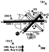
Runways
Runway Summary
| Runways: | 05/23 08/26 10/28 |
| Longest Runway: | 10/28 is 8500 ft (2591 m) long |
| Runways with an Instrument Approach: | 10 |
LAL Airport Runway Details
| Runway 05/23 | 5000 ft x 150 ft (1524 m x 46 m) | |
| Runway Length Source: | 3RD PARTY SURVEY as of 12/28/2019 | |
| Surface: | Asphalt - Fair condition - Saw-cut or plastic grooved | |
| Runway Pavement Class: | 35 /F/A/X/T | |
| Runway Edge Lights: | High Intensity | |
Runway Weight Bearing Capacity (in thousands of pounds) |
||
| Single Wheel Landing Gear: | 94.0 | |
| Dual Wheel Landing Gear: | 150.0 | |
Runway 05 |
Runway 23 |
|
Elevation: |
130.2 | 141.1 |
Latitude: |
27-59-00.4228N | 27-59-35.5186N |
Longitude: |
082-01-13.3438W | 082-00-34.0071W |
|
Runway True Alignment: |
045 | 225 |
Glide Path Angle: |
3.0 degrees | 3.0 degrees |
Traffic Pattern: |
Left | Left |
Runway Markings Type: |
Precision Instrument | Nonprecision Instrument |
Runway Markings Condition: |
Good | Good |
Object at End: |
TREES | |
Object Height: |
34 | |
Distance from End: |
1380 | |
Object Centerline Offset: |
125 ft. left of centerline | |
Visual Glide Slope Indicators: |
4-Light PAPI On Left Side Of Runway | 4-Light PAPI On Left Side Of Runway |
Threshold Crossing Height: |
59 | 46 |
Declared Distances |
||
Take Off Run Avbl. (TORA): |
5000 | 5000 |
Take Off Distance Avbl. (TODA): |
5000 | 5000 |
Actual Stop Dist. Avbl. (ASDA): |
5000 | 5000 |
Landing Dist. Avbl. (LDA): |
5000 | 5000 |
| Runway 08/26 | 2208 ft x 60 ft (673 m x 18 m) | |
| Runway Length Source: | 3RD PARTY SURVEY as of 12/28/2019 | |
| Surface: | Asphalt - Fair condition - No special surface treatment | |
Runway 08 |
Runway 26 |
|
Elevation: |
127.5 | 131.1 |
Latitude: |
27-58-47.2700N | 27-58-47.2731N |
Longitude: |
082-01-30.3132W | 082-01-05.6918W |
|
Runway True Alignment: |
090 | 270 |
Glide Path Angle: |
0.0 degrees | 0.0 degrees |
Runway Markings Type: |
Nonstandard (other than numbers only) | None |
Runway Markings Condition: |
Good | Good |
Object at End: |
TREES | HANGAR |
Object Height: |
51 | 55 |
Distance from End: |
820 | 650 |
Object Centerline Offset: |
125 ft. left of centerline | |
Threshold Elevation: |
128.2 | 131.2 |
Displaced Threshold: |
362 | 556 |
Threshold Latitude: |
27-58-47.2698N | 27-58-47.2730N |
Threshold Longitude: |
082-01-26.2722W | 082-01-11.8903W |
Declared Distances |
||
Take Off Run Avbl. (TORA): |
1650 | 1845 |
Take Off Distance Avbl. (TODA): |
2010 | 2205 |
Actual Stop Dist. Avbl. (ASDA): |
2205 | 2205 |
Landing Dist. Avbl. (LDA): |
1845 | 1650 |
| Runway 10/28 | 8500 ft x 150 ft (2591 m x 46 m) | |
| Runway Length Source: | 3RD PARTY SURVEY as of 12/28/2019 | |
| Surface: | Asphalt - Fair condition - Saw-cut or plastic grooved | |
| Runway Pavement Class: | 79 /F/A/X/T | |
| Runway Edge Lights: | High Intensity | |
Runway Weight Bearing Capacity (in thousands of pounds) |
||
| Single Wheel Landing Gear: | 50.0 | |
| Dual Wheel Landing Gear: | 250.0 | |
| Dual Tandem Wheel Landing Gear: | 550.0 | |
| Dual Dual Tandem Wheel Landing Gear: | 1120.0 | |
Runway 10 |
Runway 28 |
|
Elevation: |
131.7 | 141.8 |
Latitude: |
27-59-21.2535N | 27-59-21.4584N |
Longitude: |
082-02-01.9271W | 082-00-27.1183W |
|
Runway True Alignment: |
090 | 270 |
ILS Type: |
ILS/DME | |
Glide Path Angle: |
3.0 degrees | 3.0 degrees |
Traffic Pattern: |
Left | Left |
Runway Markings Type: |
Precision Instrument | Nonprecision Instrument |
Runway Markings Condition: |
Good | Good |
Object at End: |
TREES | |
Object Height: |
30 | |
Distance from End: |
1110 | |
Object Centerline Offset: |
125 ft. left of centerline | |
Visual Glide Slope Indicators: |
4-Light PAPI On Right Side Of Runway | 4-Light PAPI On Left Side Of Runway |
Runway Visual Range (RVR): |
Touchdown, Midfield, Rollout | Touchdown, Midfield, Rollout |
Approach Light System: |
Standard 2,400 Foot High Intensity Approach Lighting System With Sequenced Flashers, Cat. II or III Config. | |
Touchdown Lights: |
Yes | |
Centerline Lights: |
Yes | Yes |
Threshold Crossing Height: |
71 | 71 |
Declared Distances |
||
Take Off Run Avbl. (TORA): |
8500 | 8500 |
Take Off Distance Avbl. (TODA): |
8500 | 8500 |
Actual Stop Dist. Avbl. (ASDA): |
8500 | 8500 |
Landing Dist. Avbl. (LDA): |
8500 | 8500 |
Services
Airframe Repair: |
Major |
Powerplant Repair: |
Major |
Bottled Oxygen: |
None |
Bulk Oxygen: |
None |
Fuel Available: |
100LL, Jet A |
Landing Fees: |
No |
Parking: |
Tiedowns available |
Maps & Diagrams
LAL Sectional
Flight Planning
at skyvector.com
at skyvector.com