Location
Latitude: |
27-56-36.0910N (27.943359) |
Longitude: |
081-47-00.3740W (-81.783437) |
Elevation: |
124.6 feet MSL (38 m MSL) |
Magnetic Variation: |
6.5 W (as of April 2024 from WMM2020 model) |
Time Zone: |
UTC -5.0 (Standard Time) UTC -4.0 (Daylight Savings Time) |
From City: |
04 N.M. NE of Bartow, Florida |
Found On: |
Miami Chart |
FAA Region: |
ASO |
Contacts
Manager: |
Publicly owned: |
| JOHN B. HELMS, II 5993 AIRPORT BLVD BARTOW, FL 33830 863-533-1195 |
BARTOW MUNI ARPT DVLPMNT AUTH PO BOX 650 BARTOW, FL 33831-0650 863-533-1195 |
Operations
Airport Status: |
Operational |
Facility Use: |
Public |
Type: |
Airport |
Activation Date: |
02/1944 |
Control tower: |
Yes |
Attendance (Months/Days/Hours): |
Months/Days/Hours ALL/ALL/0600-1800 |
Boundary ARTCC: |
ZMA (Miami) |
Responsible ARTCC: |
ZMA (Miami) |
Lighting Schedule: |
SEE RMK |
Segmented Circle Indicator: |
Yes, Lighted |
Traffic Pattern Altitude (MSL): |
1125 feet (343 m) |
NOTAMs Facility: |
BOW |
NOTAM-D Service: |
Yes |
International Airport of Entry: |
No |
Customs Landing Rights: |
No |
Military Landing Rights: |
Yes |
Civil/Military Joint Use: |
No |
Based Aircraft
| Single Engine: | 109 |
| Multi Engine: | 13 |
| Jet Engine: | 4 |
| GA Helicopters: | 8 |
| Gliders: | 1 |
Annual Operations (as of 11/29/2023)
| Total Operations: | 64032 | |
| Air Taxi: | 1515 | 2.4% |
| GA Local: | 20207 | 31.6% |
| GA Itinerant: | 42253 | 66.0% |
| Military Aircraft: | 57 | 0.1% |
Communications
| CTAF: | 121.200 |
| Unicom: | 122.950 |
| Tower: | BARTOW 121.2 121.5R Hrs: 0730-1730 |
| Ground: | 121.9 |
| Approach: | TAMPA 119.9 119.9 119.9 |
| Departure: | TAMPA 119.9 119.9 119.9 |
| AWOS-3: | 123.775 (863-533-9004) |
| EMERG: | 121.5 |
- ATCT CLSD EASTER; THANKSGIVING; CHRISTMAS; & OTHER HOLS BY NOTAM.
Fixed Based Operators (FBOs) & Fuel
(Click on a business for detail)
Please help us keep this information up to date. This is a FREE SERVICE just like everything else on Airport Guide! If you see that a business needs to be added, modified, or deleted please fill out our Update Form.
To add, modify, or delete a business click here.
Please help us keep this information up to date. This is a FREE SERVICE just like everything else on Airport Guide! If you see that a business needs to be added, modified, or deleted please fill out our Update Form.
Area Code: 863 |
| Business Name | Frequency | Phone | Fuel Grade |
|---|---|---|---|
| Aircraft Engineering, Inc.
Update FBO info |
533-1870, -6461 | ||
| Bartow Flying Service
Update FBO info |
Unicom 122.95 | 533-1195 | 100LL, Jet A |
Flight Service Stations
| Primary | Alternate | |
| FSS on Field: | N | |
| FSS Name (ID): | Saint Petersburg(PIE) | |
| Frequency: | ||
| Toll Free Phone: | 1-800-WX-BRIEF |
Instrument Procedures / Charts
FAA Terminal Procedures valid from 0901Z 03/21/24 to 0901Z 04/18/24.
There are various types of charts available for an airport. They are listed in the Page Type column. Here is a legend for those types:
APD - Airport Diagram
DP - Departure Procedure Charts
HOT - Hot Spots
IAP - Instrument Approach Procedure Charts
MIN - Minimums
STAR - Standard Terminal Arrival Charts
| Page Type | Page Name | Volume | Action Since Last Cycle |
|---|---|---|---|
| APD | AIRPORT DIAGRAM | SE-3 | |
| IAP | RNAV (GPS) RWY 05 | SE-3 | |
| IAP | RNAV (GPS) RWY 09L | SE-3 | |
| IAP | RNAV (GPS) RWY 23 | SE-3 | |
| IAP | RNAV (GPS) RWY 27R | SE-3 | |
| IAP | VOR RWY 09L | SE-3 | |
| MIN | ALTERNATE MINIMUMS | SE-3 | |
| MIN | TAKEOFF MINIMUMS | SE-3 |
Terminal Procedures are only available for airports in several countries with more being added all the time. If you are looking for a specific country's charts, please send an email to support(at)airportguide.com stating the country name. This will be used to prioritize the implementation.
Navigation Aids (Navaids) near BOW
| Dist (NM) | ID | Morse Code | Name | Type | Freq | True Hdg | Mag Hdg |
|---|---|---|---|---|---|---|---|
| 12.5 | LAL | . _ . . . _ . _ . . | Lakeland | VORTAC | 116.00 | 281 | 287 |
| 26.1 | RHZ | . _ . . . . . _ _ . . | Zephyrhills | NDB | 253 | 310 | 316 |
| 38.5 | OR | _ _ _ . _ . | Herny | NDB | 221 | 28 | 35 |
| 39.0 | MCF | _ _ _ . _ . . . _ . | Macdill | TACAN | 111.00 | 262 | 268 |
| 39.7 | TPA | _ . _ _ . . _ | Tampa Intl | VOT | 111.00 | 272 | 278 |
| 40.2 | TP | _ . _ _ . | Cosme | NDB | 368 | 282 | 288 |
| 40.7 | AM | . _ _ _ | Picny | NDB | 388 | 263 | 269 |
| 43.1 | ORL | _ _ _ . _ . . _ . . | Orlando | VORTAC | 112.20 | 33 | 40 |
| 47.8 | PIE | . _ _ . . . . | St Petersburg | VORTAC | 116.40 | 267 | 273 |
| 48.9 | PI | . _ _ . . . | Capok | NDB | 360 | 273 | 279 |
| 52.5 | SRQ | . . . . _ . _ _ . _ | Sarasota | VOR-DME | 117.00 | 232 | 238 |
| 52.5 | LEE | . _ . . . . | Leesburg | NDB | 335 | 358 | 365 |
| 58.0 | SFB | . . . . . _ . _ . . . | Sanford | NDB | 408 | 29 | 36 |
| 58.1 | SQT | . . . _ _ . _ _ | Satellite | NDB | 257 | 80 | 87 |
| 61.6 | MLB | _ _ . _ . . _ . . . | Melbourne | VOR-DME | 115.85 | 80 | 87 |
| 62.5 | TVV | _ . . . _ . . . _ | Space Center Executive | NDB | 237 | 56 | 63 |
| 62.6 | PGD | . _ _ . _ _ . _ . . | Punta Gorda | VOR | 110.20 | 190 | 196 |
| 63.1 | VNC | . . . _ _ . _ . _ . | Venice | NDB | 206 | 213 | 219 |
| 64.5 | COF | _ . _ . _ _ _ . . _ . | Patrick | TACAN | 115.00 | 73 | 80 |
| 70.1 | LBV | . _ . . _ . . . . . . _ | La Belle | VORTAC | 110.40 | 162 | 169 |
Nearby Airports with Fuel
Notices to Airmen (NOTAMS)
Remarks
| A110-2 | OVERHEAD PLINES IN T-HANGAR AREA - APPROX 20' VERTICAL CLEARANCE. |
| A110-5 | WILDLIFE INVOF ARPT. |
| A110-6 | WHEN ATCT CLSD, FOR CD CTC TAMPA APCH AT 813-878-2528 |
| A17 | UNATTND EASTER, INDEPENDANCE DAY, THANKSGIVING & CHRISTMAS. |
| A33-05/23 | CRACKING THRUT RWY 05/23. |
| A33-09R/27L | RWY 09R/27L PRODUCING LOOSE AGGREGATE IN SOME AREAS. |
| A33-09R/27L | 1 RWY 27L CONC 1ST 300 FT. |
| A70-FUEL-10 | 0LL 100LL AVBL 24 HRS WITH CREDIT CARD. |
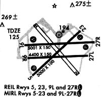
| A81-APT | ACTVT REILS RWY 05, 09L, 23 & 27R; PAPI RWYS 05, 09L, 23, & 27R; MIRL RWYS 05/23 & 09L/27R; AND WIND CONE - CTAF. REIL RWYS 05, 09L, 23 & 27R OPER WHEN MIRL RWYS 05/23 & 09L/27R HIGH INTST ONLY. |
Runways
Runway Summary
| Runways: | 05/23 09L/27R 09R/27L |
| Longest Runway: | 05/23 is 5001 ft (1524 m) long |
| Runways with an Instrument Approach: |
BOW Airport Runway Details
| Runway 05/23 | 5001 ft x 100 ft (1524 m x 30 m) | |
| Runway Length Source: | 3RD PARTY SURVEY as of 12/21/2020 | |
| Surface: | Asphalt - Poor condition - No special surface treatment | |
| Runway Pavement Class: | 27 /F/A/X/T | |
| Runway Edge Lights: | Medium Intensity | |
Runway Weight Bearing Capacity (in thousands of pounds) |
||
| Single Wheel Landing Gear: | 35.0 | |
| Dual Wheel Landing Gear: | 60.0 | |
| Dual Tandem Wheel Landing Gear: | 110.0 | |
Runway 05 |
Runway 23 |
|
Elevation: |
107.9 | 122.2 |
Latitude: |
27-56-17.3248N | 27-56-51.6676N |
Longitude: |
081-47-21.8340W | 081-46-41.6717W |
|
Runway True Alignment: |
046 | 226 |
Glide Path Angle: |
3.5 degrees | 3.5 degrees |
Traffic Pattern: |
Left | Left |
Runway Markings Type: |
Nonprecision Instrument | Nonprecision Instrument |
Runway Markings Condition: |
Good | Good |
Object at End: |
TREES | TREES |
Object Height: |
33 | 45 |
Distance from End: |
1380 | 1620 |
Object Centerline Offset: |
250 ft. left of centerline | 250 ft. left of centerline |
Visual Glide Slope Indicators: |
4-Light PAPI On Left Side Of Runway | 4-Light PAPI On Left Side Of Runway |
REIL: |
Yes | Yes |
Threshold Crossing Height: |
51 | 48 |
| Runway 09L/27R | 5000 ft x 150 ft (1524 m x 46 m) | |
| Runway Length Source: | 3RD PARTY SURVEY as of 12/21/2020 | |
| Surface: | Asphalt - Poor condition - No special surface treatment | |
| Runway Pavement Class: | 48 /F/A/W/T | |
| Runway Edge Lights: | Medium Intensity | |
Runway 09L |
Runway 27R |
|
Elevation: |
116.9 | 114.5 |
Latitude: |
27-56-40.3841N | 27-56-42.9061N |
Longitude: |
081-47-26.1985W | 081-46-30.5194W |
|
Runway True Alignment: |
087 | 267 |
Glide Path Angle: |
3.0 degrees | 3.0 degrees |
Runway Markings Type: |
Nonprecision Instrument | Nonprecision Instrument |
Runway Markings Condition: |
Good | Good |
Object at End: |
TREE | TREE |
Object Height: |
62 | 28 |
Distance from End: |
2290 | 1130 |
Object Centerline Offset: |
250 ft. left of centerline | 250 ft. left of centerline |
Visual Glide Slope Indicators: |
4-Light PAPI On Left Side Of Runway | 4-Light PAPI On Left Side Of Runway |
REIL: |
Yes | Yes |
Threshold Crossing Height: |
46 | 34 |
| Runway 09R/27L | 4416 ft x 150 ft (1346 m x 46 m) | |
| Runway Length Source: | 3RD PARTY SURVEY as of 12/21/2020 | |
| Surface: | Asphalt - Poor condition - No special surface treatment | |
| Runway Pavement Class: | 6 /F/A/Y/T | |
Runway 09R |
Runway 27L |
|
Elevation: |
112.3 | 111.6 |
Latitude: |
27-56-30.4906N | 27-56-32.7254N |
Longitude: |
081-47-25.6833W | 081-46-36.5058W |
|
Runway True Alignment: |
087 | 267 |
Glide Path Angle: |
0.0 degrees | 0.0 degrees |
Traffic Pattern: |
Left | Left |
Runway Markings Type: |
Basic | Basic |
Runway Markings Condition: |
Good | Good |
Object at End: |
TREES | TREES |
Object Height: |
56 | 40 |
Distance from End: |
1900 | 1000 |
Object Centerline Offset: |
250 ft. left of centerline | 250 ft. left of centerline |
Services
Airframe Repair: |
Major |
Powerplant Repair: |
Major |
Bottled Oxygen: |
None |
Bulk Oxygen: |
None |
Fuel Available: |
100LL |
Landing Fees: |
No |
Parking: |
Tiedowns available |
Maps & Diagrams
BOW Sectional
Flight Planning
at skyvector.com
at skyvector.com