Location
Latitude: |
28-13-36.0100N (28.226669) |
Longitude: |
082-09-20.3230W (-82.155645) |
Elevation: |
89.9 feet MSL (27 m MSL) |
Magnetic Variation: |
6.3 W (as of April 2024 from WMM2020 model) |
Time Zone: |
UTC -5.0 (Standard Time) UTC -4.0 (Daylight Savings Time) |
From City: |
01 N.M. SE of Zephyrhills, Florida |
Found On: |
Jacksonville Chart |
FAA Region: |
ASO |
Contacts
Manager: |
Publicly owned: |
| NATHAN COLEMAN ZEPHYRHILLS MUNICIPAL AIRPORT, 39450 SOUTH AVENUE ZEPHYRHILLS, FL 33542 813-780-0030 |
CITY OF ZEPHYRHILLS 39450 SOUTH AVENUE ZEPHYRHILLS, FL 33542 813-780-0030 |
Operations
Airport Status: |
Operational |
Facility Use: |
Public |
Type: |
Airport |
Activation Date: |
12/1942 |
Control tower: |
No |
Attendance (Months/Days/Hours): |
Months/Days/Hours ALL/MON-SAT/0800-1700 |
Boundary ARTCC: |
ZJX (Jacksonville) |
Responsible ARTCC: |
ZMA (Miami) |
Lighting Schedule: |
SEE RMK |
Segmented Circle Indicator: |
Yes, Lighted |
Traffic Pattern Altitude (MSL): |
1090 feet (332 m) |
NOTAMs Facility: |
PIE |
NOTAM-D Service: |
Yes |
International Airport of Entry: |
No |
Customs Landing Rights: |
No |
Military Landing Rights: |
Yes |
Civil/Military Joint Use: |
No |
Based Aircraft
| Single Engine: | 93 |
| Multi Engine: | 8 |
| GA Helicopters: | 7 |
| Ultralights: | 1 |
Annual Operations (as of 12/12/2017)
| Total Operations: | 49425 | |
| Air Taxi: | 150 | 0.3% |
| GA Local: | 32850 | 66.5% |
| GA Itinerant: | 16425 | 33.2% |
Communications
| CTAF: | 123.075 |
| Unicom: | 123.075 |
| AWOS-3PT: | 118.975 (813-780-0031) |
Fixed Based Operators (FBOs) & Fuel
(Click on a business for detail)
Please help us keep this information up to date. This is a FREE SERVICE just like everything else on Airport Guide! If you see that a business needs to be added, modified, or deleted please fill out our Update Form.
To add, modify, or delete a business click here.
Please help us keep this information up to date. This is a FREE SERVICE just like everything else on Airport Guide! If you see that a business needs to be added, modified, or deleted please fill out our Update Form.
Area Code: 813 |
| Business Name | Frequency | Phone | Fuel Grade |
|---|---|---|---|
| Aero Center, Inc.
Update FBO info |
782-7789 | 100LL, Jet A |
Flight Service Stations
| Primary | Alternate | |
| FSS on Field: | N | |
| FSS Name (ID): | Saint Petersburg(PIE) | |
| Frequency: | ||
| Toll Free Phone: | 1-800-WX-BRIEF |
Instrument Procedures / Charts
FAA Terminal Procedures valid from 0901Z 03/21/24 to 0901Z 04/18/24.
There are various types of charts available for an airport. They are listed in the Page Type column. Here is a legend for those types:
APD - Airport Diagram
DP - Departure Procedure Charts
HOT - Hot Spots
IAP - Instrument Approach Procedure Charts
MIN - Minimums
STAR - Standard Terminal Arrival Charts
| Page Type | Page Name | Volume | Action Since Last Cycle |
|---|---|---|---|
| IAP | RNAV (GPS) RWY 01 | SE-3 | |
| IAP | RNAV (GPS) RWY 05 | SE-3 | |
| IAP | RNAV (GPS) RWY 19 | SE-3 | |
| IAP | RNAV (GPS) RWY 23 | SE-3 | |
| MIN | ALTERNATE MINIMUMS | SE-3 | |
| MIN | TAKEOFF MINIMUMS | SE-3 |
Terminal Procedures are only available for airports in several countries with more being added all the time. If you are looking for a specific country's charts, please send an email to support(at)airportguide.com stating the country name. This will be used to prioritize the implementation.
Navigation Aids (Navaids) near ZPH
| Dist (NM) | ID | Morse Code | Name | Type | Freq | True Hdg | Mag Hdg |
|---|---|---|---|---|---|---|---|
| 0.1 | RHZ | . _ . . . . . _ _ . . | Zephyrhills | NDB | 253 | 288 | 294 |
| 16.3 | LAL | . _ . . . _ . _ . . | Lakeland | VORTAC | 116.00 | 152 | 158 |
| 21.3 | TP | _ . _ _ . | Cosme | NDB | 368 | 246 | 252 |
| 25.1 | TPA | _ . _ _ . . _ | Tampa Intl | VOT | 111.00 | 232 | 238 |
| 29.0 | MCF | _ _ _ . _ . . . _ . | Macdill | TACAN | 111.00 | 220 | 226 |
| 30.1 | AM | . _ _ _ | Picny | NDB | 388 | 223 | 229 |
| 32.2 | PI | . _ _ . . . | Capok | NDB | 360 | 244 | 250 |
| 33.9 | PIE | . _ _ . . . . | St Petersburg | VORTAC | 116.40 | 235 | 241 |
| 40.0 | LEE | . _ . . . . | Leesburg | NDB | 335 | 27 | 33 |
| 41.6 | OR | _ _ _ . _ . | Herny | NDB | 221 | 66 | 73 |
| 47.3 | ORL | _ _ _ . _ . . _ . . | Orlando | VORTAC | 112.20 | 66 | 73 |
| 53.7 | SRQ | . . . . _ . _ _ . _ | Sarasota | VOR-DME | 117.00 | 203 | 209 |
| 57.2 | OCF | _ _ _ _ . _ . . . _ . | Ocala | VORTAC | 113.70 | 356 | 362 |
| 58.6 | SFB | . . . . . _ . _ . . . | Sanford | NDB | 408 | 54 | 61 |
| 68.6 | DED | _ . . . _ . . | Deland/Dcmsnd | NDB | 201 | 42 | 49 |
| 71.4 | VNC | . . . _ _ . _ . _ . | Venice | NDB | 206 | 191 | 197 |
| 73.9 | TVV | _ . . . _ . . . _ | Space Center Executive | NDB | 237 | 76 | 83 |
| 77.3 | SQT | . . . _ _ . _ _ | Satellite | NDB | 257 | 95 | 102 |
| 79.1 | PGD | . _ _ . _ _ . _ . . | Punta Gorda | VOR | 110.20 | 173 | 179 |
| 80.7 | MLB | _ _ . _ . . _ . . . | Melbourne | VOR-DME | 115.85 | 94 | 101 |
Nearby Airports with Fuel
Notices to Airmen (NOTAMS)
Remarks
| A110-1 | 24 FT PLINE CROSSES APCH 800-1300 FT FROM RWY 23 END; MKD WITH RED FLAGS. |
| A110-10 | PATTERN ALTITUDE TWIN ENGINE 1500 FT AGL. |
| A110-3 | GLIDER OPS 6000 FT & BLW SR-SS. |
| A110-4 | SKY-DIVING ACFT DESCENDING FROM 13500 FT & ENTERING OPPOSITE TFC PAT FOR RWY 1/19 E OF ARPT. |
| A110-5 | PAEW ADJ TO RWYS & TWYS. |
| A110-6 | EXERCISE CAUTION; EXTENSIVE ACFT OPS ALL CATS & TYPES USING RWY 1/19; PARL TWY NOT AVBL. |
| A110-8 | NOISE SENSITIVE AREA NE & WEST OF ARPT; MNTN PAT ALTS & AVOID PWR CHG OVR RESIDENTAL AREAS. |
| A110-9 | FOR CD CTC TAMPA APCH AT 813-878-2528. |
| A70-FUEL-10 | 0LL FUEL AVBL H24 WITH CREDIT CARD; AFT HR FUEL SVC - 813-714-6797. |
| A81-APT | ACTVT PAPI RWY 01, 05, 19 & 23; REIL RWY 1 & 19 - CTAF. HIRL RWY 1/19; MIRL RWY 5/23 PRESET TO LOW INTST DUSK-2200; INCR INTST & ACTVT AFT 2200 - CTAF. |
| E111 | EXISTED PRIOR TO 1959. |
Runways
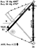
Runway Summary
| Runways: | 01/19 05/23 |
| Longest Runway: | 01/19 is 6201 ft (1890 m) long |
| Runways with an Instrument Approach: |
ZPH Airport Runway Details
| Runway 01/19 | 6201 ft x 100 ft (1890 m x 30 m) | |
| Runway Length Source: | 3RD PARTY SURVEY as of 07/20/2022 | |
| Surface: | Asphalt - Fair condition - No special surface treatment | |
| Runway Pavement Class: | 16 /F/B/X/T | |
| Runway Edge Lights: | High Intensity | |
Runway Weight Bearing Capacity (in thousands of pounds) |
||
| Single Wheel Landing Gear: | 47.0 | |
| Dual Wheel Landing Gear: | 69.0 | |
Runway 01 |
Runway 19 |
|
Elevation: |
78.7 | 89.3 |
Latitude: |
28-12-57.9420N | 28-13-59.3361N |
Longitude: |
082-09-12.2242W | 082-09-11.8478W |
|
Runway True Alignment: |
000 | 180 |
Glide Path Angle: |
3.0 degrees | 3.0 degrees |
Traffic Pattern: |
Right | |
Runway Markings Type: |
Nonprecision Instrument | Nonprecision Instrument |
Runway Markings Condition: |
Fair | Fair |
Object at End: |
TREES | TREES |
Object Height: |
49 | 75 |
Distance from End: |
2385 | 3365 |
Object Centerline Offset: |
225 ft. left of centerline | 0 ft. left and right of centerline |
Visual Glide Slope Indicators: |
4-Light PAPI On Left Side Of Runway | 4-Light PAPI On Left Side Of Runway |
REIL: |
Yes | Yes |
Threshold Crossing Height: |
45 | 43 |
| Runway 05/23 | 5001 ft x 100 ft (1524 m x 30 m) | |
| Runway Length Source: | 3RD PARTY SURVEY as of 07/20/2022 | |
| Surface: | Asphalt - Fair condition - Saw-cut or plastic grooved | |
| Runway Pavement Class: | 16 /F/A/X/T | |
| Runway Edge Lights: | Medium Intensity | |
Runway Weight Bearing Capacity (in thousands of pounds) |
||
| Single Wheel Landing Gear: | 53.0 | |
| Dual Wheel Landing Gear: | 75.0 | |
Runway 05 |
Runway 23 |
|
Elevation: |
85.4 | 87.9 |
Latitude: |
28-13-26.9503N | 28-14-03.3449N |
Longitude: |
082-09-49.5542W | 082-09-11.6413W |
|
Runway True Alignment: |
043 | 223 |
Glide Path Angle: |
3.6 degrees | 3.6 degrees |
Traffic Pattern: |
Right | |
Runway Markings Type: |
Nonprecision Instrument | Nonprecision Instrument |
Runway Markings Condition: |
Fair | Fair |
Object at End: |
TREES | TREES |
Object Height: |
59 | 42 |
Distance from End: |
2230 | 1470 |
Object Centerline Offset: |
225 ft. left of centerline | 0 ft. left and right of centerline |
Visual Glide Slope Indicators: |
4-Light PAPI On Left Side Of Runway | 4-Light PAPI On Left Side Of Runway |
Threshold Crossing Height: |
41 | 41 |
Services
Airframe Repair: |
Minor |
Powerplant Repair: |
Minor |
Fuel Available: |
100LL |
Landing Fees: |
No |
Parking: |
Hangars and tiedowns available |
Maps & Diagrams
ZPH Sectional
Flight Planning
at skyvector.com
at skyvector.com