Location
Latitude: |
28-03-27.0000N (28.0575) |
Longitude: |
081-45-46.1000W (-81.762806) |
Elevation: |
140.0 feet MSL (43 m MSL) |
Magnetic Variation: |
6.5 W (as of April 2024 from WMM2020 model) |
Time Zone: |
UTC -5.0 (Standard Time) UTC -4.0 (Daylight Savings Time) |
From City: |
03 N.M. NW of Winter Haven, Florida |
Found On: |
Jacksonville Chart |
FAA Region: |
ASO |
Contacts
Manager: |
Privately owned: |
| BEN SHIPPS JACK BROWNS SPB, 2704 U.S. HIGHWAY 92 WINTER HAVEN, FL 33880 863-956-2243 |
JON K. BROWN 2704 U.S. HIGHWAY 92 WINTER HAVEN, FL 33881 863-956-2243 |
Operations
Airport Status: |
Operational |
Facility Use: |
Public |
Type: |
Seaplane Base |
Control tower: |
No |
Attendance (Months/Days/Hours): |
Months/Days/Hours ALL/ALL/DALGT |
Boundary ARTCC: |
ZMA (Miami) |
Responsible ARTCC: |
ZMA (Miami) |
Segmented Circle Indicator: |
No |
Traffic Pattern Altitude (MSL): |
1140 feet (347 m) |
NOTAMs Facility: |
PIE |
NOTAM-D Service: |
Yes |
International Airport of Entry: |
No |
Customs Landing Rights: |
No |
Military Landing Rights: |
No |
Civil/Military Joint Use: |
No |
Based Aircraft
| Single Engine: | 6 |
Annual Operations (as of 07/23/2018)
| Total Operations: | 10000 | |
| GA Local: | 9500 | 95.0% |
| GA Itinerant: | 500 | 5.0% |
Communications
| CTAF: | 123.050 |
Fixed Based Operators (FBOs) & Fuel
(Click on a business for detail)
Please help us keep this information up to date. This is a FREE SERVICE just like everything else on Airport Guide! If you see that a business needs to be added, modified, or deleted please fill out our Update Form.
To add, modify, or delete a business click here.
Please help us keep this information up to date. This is a FREE SERVICE just like everything else on Airport Guide! If you see that a business needs to be added, modified, or deleted please fill out our Update Form.
Area Code: 863 |
| Business Name | Frequency | Phone | Fuel Grade |
|---|---|---|---|
| Jack Brown's Seaplane Corp.
Update FBO info |
956-2243, 967-5918 | 100LL |
Flight Service Stations
| Primary | Alternate | |
| FSS on Field: | N | |
| FSS Name (ID): | Saint Petersburg(PIE) | |
| Frequency: | ||
| Toll Free Phone: | 1-800-WX-BRIEF |
Instrument Procedures / Charts
Terminal Procedures are only available for airports in several countries with more being added all the time. If you are looking for a specific country's charts, please send an email to support(at)airportguide.com stating the country name. This will be used to prioritize the implementation.
Navigation Aids (Navaids) near F57
| Dist (NM) | ID | Morse Code | Name | Type | Freq | True Hdg | Mag Hdg |
|---|---|---|---|---|---|---|---|
| 14.0 | LAL | . _ . . . _ . _ . . | Lakeland | VORTAC | 116.00 | 252 | 258 |
| 23.2 | RHZ | . _ . . . . . _ _ . . | Zephyrhills | NDB | 253 | 296 | 302 |
| 32.1 | OR | _ _ _ . _ . | Herny | NDB | 221 | 32 | 39 |
| 36.9 | ORL | _ _ _ . _ . . _ . . | Orlando | VORTAC | 112.20 | 37 | 44 |
| 40.4 | TP | _ . _ _ . | Cosme | NDB | 368 | 272 | 278 |
| 41.1 | TPA | _ . _ _ . . _ | Tampa Intl | VOT | 111.00 | 263 | 269 |
| 41.5 | MCF | _ _ _ . _ . . . _ . | Macdill | TACAN | 111.00 | 253 | 259 |
| 43.1 | AM | . _ _ _ | Picny | NDB | 388 | 254 | 260 |
| 45.7 | LEE | . _ . . . . | Leesburg | NDB | 335 | 357 | 364 |
| 49.6 | PIE | . _ _ . . . . | St Petersburg | VORTAC | 116.40 | 259 | 265 |
| 50.0 | PI | . _ _ . . . | Capok | NDB | 360 | 265 | 271 |
| 51.5 | SFB | . . . . . _ . _ . . . | Sanford | NDB | 408 | 32 | 39 |
| 56.3 | SQT | . . . _ _ . _ _ | Satellite | NDB | 257 | 87 | 94 |
| 57.7 | SRQ | . . . . _ . _ _ . _ | Sarasota | VOR-DME | 117.00 | 227 | 233 |
| 58.0 | TVV | _ . . . _ . . . _ | Space Center Executive | NDB | 237 | 61 | 68 |
| 59.8 | MLB | _ _ . _ . . _ . . . | Melbourne | VOR-DME | 115.85 | 86 | 93 |
| 61.8 | COF | _ . _ . _ _ _ . . _ . | Patrick | TACAN | 115.00 | 79 | 86 |
| 65.8 | DED | _ . . . _ . . | Deland/Dcmsnd | NDB | 201 | 22 | 29 |
| 69.5 | PGD | . _ _ . _ _ . _ . . | Punta Gorda | VOR | 110.20 | 190 | 196 |
| 69.5 | VNC | . . . _ _ . _ . _ . | Venice | NDB | 206 | 210 | 216 |
Nearby Airports with Fuel
Notices to Airmen (NOTAMS)
Remarks
| A110-1 | RCMD NORTH-SOUTH PAT TO RMN CLEAR OF AND BLW 900 FT TFC AT WINTER HAVEN RGNL ARPT. |
| A110-2 | SEAPLANE FACILITIES FOR LIGHT AIRCRAFT. |
| A110-3 | TWY TO WINTER HAVEN RGNL ARPT. |
| A110-4 | FOR CD CTC TAMPA APCH AT 813-878-2528 |
| A42-01W | RY 01/19 UNMARKED. |
| A82 | CTC WINTER HAVEN RGNL ARPT UNICOM FOR BOAT ACTVTY & LCL TFC. |
| E111 | VFR OPNS ONLY |
Runways
Runway Summary
| Runways: | 01W/19W |
| Longest Runway: | 01W/19W is 3600 ft (1097 m) long |
| Runways with an Instrument Approach: |
F57 Airport Runway Details
| Waterway 01W/19W | 3600 ft x 2200 ft (1097 m x 671 m) | |
| Runway Length Source: | OWNER as of 10/11/2004 | |
| Surface: | Water - No special surface treatment | |
Waterway 01W |
Runway 19W |
|
Elevation: |
140.0 | 140.0 |
Latitude: |
28-03-09.1600N | 28-03-45.0500N |
Longitude: |
081-45-49.3000W | 081-45-42.7900W |
Glide Path Angle: |
0.0 degrees | 0.0 degrees |
Displaced Threshold: |
1200 | 1000 |
Services
Airframe Repair: |
Major |
Powerplant Repair: |
Major |
Bottled Oxygen: |
None |
Bulk Oxygen: |
None |
Fuel Available: |
100LL, Jet A, UL94 |
Landing Fees: |
No |
Parking: |
Hangars and tiedowns available |
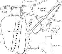
Maps & Diagrams
F57 Sectional
Flight Planning
at skyvector.com
at skyvector.com