Location
Latitude: |
42-16-05.2080N (42.268113) |
Longitude: |
079-28-54.1680W (-79.481713) |
Elevation: |
1330.0 feet MSL (405 m MSL) |
Magnetic Variation: |
9.9 W (as of April 2024 from WMM2020 model) |
Time Zone: |
UTC -5.0 (Standard Time) UTC -4.0 (Daylight Savings Time) |
From City: |
02 N.M. E of Mayville, New York |
Found On: |
Detroit Chart |
FAA Region: |
AEA |
Contacts
Manager: |
Privately owned: |
| GREGORY G. DART 6167 PLANK RD MAYVILLE, NY 14757 716-753-6711 |
GREGORY G. DART PO BOX 211 MAYVILLE, NY 14757 716-753-2160 |
Operations
Airport Status: |
Operational |
Facility Use: |
Public |
Type: |
Airport |
Activation Date: |
09/1971 |
Control tower: |
No |
Attendance (Months/Days/Hours): |
Months/Days/Hours ALL/ALL/DALGT |
Boundary ARTCC: |
ZOB (Cleveland) |
Responsible ARTCC: |
ZOB (Cleveland) |
Segmented Circle Indicator: |
No |
Traffic Pattern Altitude (MSL): |
2330 feet (710 m) |
NOTAMs Facility: |
BUF |
NOTAM-D Service: |
Yes |
Based Aircraft
| Single Engine: | 37 |
| Gliders: | 6 |
| Ultralights: | 2 |
Annual Operations (as of 08/26/2021)
| Total Operations: | 900 | |
| GA Local: | 800 | 88.9% |
| GA Itinerant: | 100 | 11.1% |
Communications
| CTAF: | 122.900 |
Fixed Based Operators (FBOs) & Fuel
(Click on a business for detail)
Please help us keep this information up to date. This is a FREE SERVICE just like everything else on Airport Guide! If you see that a business needs to be added, modified, or deleted please fill out our Update Form.
To add, modify, or delete a business click here.
Please help us keep this information up to date. This is a FREE SERVICE just like everything else on Airport Guide! If you see that a business needs to be added, modified, or deleted please fill out our Update Form.
Area Code: 716 |
| Business Name | Frequency | Phone | Fuel Grade |
|---|---|---|---|
| R.D. Aircraft Co.
Update FBO info |
Unicom 122.9 | 753-2160 |
Flight Service Stations
| Primary | Alternate | |
| FSS on Field: | N | |
| FSS Name (ID): | Buffalo(BUF) | |
| Frequency: | ||
| Toll Free Phone: | 1-800-WX-BRIEF |
Instrument Procedures / Charts
Terminal Procedures are only available for airports in several countries with more being added all the time. If you are looking for a specific country's charts, please send an email to support(at)airportguide.com stating the country name. This will be used to prioritize the implementation.
Navigation Aids (Navaids) near D79
| Dist (NM) | ID | Morse Code | Name | Type | Freq | True Hdg | Mag Hdg |
|---|---|---|---|---|---|---|---|
| 16.2 | DKK | _ . . _ . _ _ . _ | Dunkirk | DME | 116.2 | 34 | 44 |
| 16.7 | JHW | . _ _ _ . . . . . _ _ | Jamestown | VOR-DME | 114.70 | 106 | 116 |
| 22.6 | ORJ | _ _ _ . _ . . _ _ _ | Corry | NDB | 258 | 199 | 209 |
| 29.1 | CQD | _ . _ . _ _ . _ _ . . | Cascade | NDB | 372 | 252 | 262 |
| 33.4 | TDT | _ _ . . _ | Tidioute | DME | 117.6 | 175 | 185 |
| 37.1 | ERI | . . _ . . . | Esmer | NDB | 349 | 248 | 258 |
| 39.1 | ERI | . . _ . . . | Erie | TACAN | 109.40 | 247 | 257 |
| 46.7 | GB | _ _ . _ . . . | Plazz | NDB | 204 | 38 | 48 |
| 48.1 | BFD | _ . . . . . _ . _ . . | Bradford | DME | 116.6 | 126 | 136 |
| 50.9 | LYS | . _ . . _ . _ _ . . . | Olean | NDB | 360 | 88 | 98 |
| 52.1 | BUF | _ . . . . . _ . . _ . | Buffalo | VOT | 109.00 | 39 | 49 |
| 52.5 | FKL | . . _ . _ . _ . _ . . | Franklin | VOR | 109.60 | 198 | 208 |
| 53.7 | SN | St. Catharines | NDB | 408 | 10 | 20 | |
| 54.2 | BUF | _ . . . . . _ . . _ . | Buffalo | DME | 116.4 | 42 | 52 |
| 54.3 | ZHM | Binbrook | NDB | 266 | 345 | 355 | |
| 55.6 | IAG | . . . _ _ _ . | Niagara Falls | TACAN | 111.00 | 24 | 34 |
| 56.2 | HM | Hamilton | NDB | 221 | 335 | 345 | |
| 57.2 | BU | _ . . . . . _ | Klump | NDB | 231 | 39 | 49 |
| 57.9 | IA | . . . _ | Kathi | NDB | 329 | 29 | 39 |
| 60.7 | ZHA | Ancaster | NDB | 397 | 336 | 346 |
Nearby Airports with Fuel
Notices to Airmen (NOTAMS)
Remarks
| A110-1 | EXTSV GLIDER OPNS ON & INVOF ARPT. |
| A110-2 | ULTRALIGHT ACTIVITY ON & INVOF ARPT. |
| A110-3 | P-LINE RUNNING ALG N SIDE OF RT. 430. |
| A110-5 | FOR CD CTC BUFFALO APCH AT 716-626-6920, WHEN APCH CLSD CTC CLEVELAND ARTCC AT 440-774-0232. |
| A52-06 | +30 FT PLINE, 45 FT FM THR, ACRS BOTH SIDES. |
| A52-13 | 46 FT PLINE CROSSES RWY CNTRLN RIGHT TO LEFT 338 FT FM THR. |
| A52-31 | 30 FT PLINE CROSSES RWY CNTRLN 315 FT FM THR. |
Runways
Runway Summary
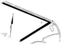
| Runways: | 06/24 10/28 13/31 |
| Longest Runway: | 10/28 is 3800 ft (1158 m) long |
| Runways with an Instrument Approach: |
D79 Airport Runway Details
| Runway 06/24 | 1840 ft x 80 ft (561 m x 24 m) | |
| Surface: | Turf - Good condition - No special surface treatment | |
Runway 06 |
Runway 24 |
|
Glide Path Angle: |
0.0 degrees | 0.0 degrees |
Traffic Pattern: |
Left | Left |
Object at End: |
TREES | TREE |
Object Height: |
59 | 34 |
Distance from End: |
2 | 0 |
Object Centerline Offset: |
96 ft. left of centerline | 99 ft. left of centerline |
| Runway 10/28 | 3800 ft x 60 ft (1158 m x 18 m) | |
| Surface: | Turf - Good condition - No special surface treatment | |
Runway 10 |
Runway 28 |
|
Glide Path Angle: |
0.0 degrees | 0.0 degrees |
Object at End: |
TREES | HANGAR |
Object Height: |
85 | 19 |
Distance from End: |
370 | 53 |
Object Centerline Offset: |
96 ft. left of centerline | 99 ft. left of centerline |
| Runway 13/31 | 2750 ft x 60 ft (838 m x 18 m) | |
| Surface: | Turf - Good condition - No special surface treatment | |
Runway 13 |
Runway 31 |
|
Glide Path Angle: |
0.0 degrees | 0.0 degrees |
Traffic Pattern: |
Left | Left |
Object at End: |
PLINE | POLE |
Object Height: |
40 | 30 |
Distance from End: |
1 | 32 |
Object Centerline Offset: |
96 ft. left of centerline | 99 ft. left of centerline |
Services
Airframe Repair: |
None |
Powerplant Repair: |
None |
Bottled Oxygen: |
None |
Bulk Oxygen: |
None |
Fuel Available: |
100LL, Jet A |
Parking: |
Hangars and tiedowns available |
Maps & Diagrams
D79 Sectional
Flight Planning
at skyvector.com
at skyvector.com