Location
Latitude: |
36-57-52.3000N (36.964528) |
Longitude: |
086-25-10.8000W (-86.419667) |
Elevation: |
547.2 feet MSL (167 m MSL) |
Magnetic Variation: |
4.5 W (as of April 2024 from WMM2020 model) |
Time Zone: |
UTC -6.0 (Standard Time) UTC -5.0 (Daylight Savings Time) |
From City: |
02 N.M. SE of Bowling Green, Kentucky |
Found On: |
St Louis Chart |
FAA Region: |
ASO |
Contacts
Manager: |
Publicly owned: |
| SUSAN HARMON 1000 WOODHURST ST BOWLING GREEN, KY 42103 270-842-1101 |
CITY BOWLING GREEN-WARREN CO 1000 WOODHURST ST BOWLING GREEN, KY 42103 270-842-1101 |
Operations
Airport Status: |
Operational |
Facility Use: |
Public |
Type: |
Airport |
Activation Date: |
04/1940 |
Control tower: |
No |
Attendance (Months/Days/Hours): |
Months/Days/Hours ALL/ALL/ALL |
Boundary ARTCC: |
ZME (Memphis) |
Responsible ARTCC: |
ZME (Memphis) |
Lighting Schedule: |
SEE RMK |
Segmented Circle Indicator: |
No |
Traffic Pattern Altitude (MSL): |
1547 feet (472 m) |
NOTAMs Facility: |
BWG |
NOTAM-D Service: |
Yes |
International Airport of Entry: |
No |
Customs Landing Rights: |
No |
Military Landing Rights: |
Yes |
Civil/Military Joint Use: |
No |
Aircraft Rescue and Firefighting: |
Class IV ARFF Index: A Air Carrier Service: Not Scheduled Certification Date: 05/1976 |
Based Aircraft
| Single Engine: | 54 |
| Multi Engine: | 9 |
| Jet Engine: | 5 |
| GA Helicopters: | 2 |
Annual Operations (as of 12/31/2022)
| Total Operations: | 9814 | |
| Commercial: | 12 | 0.1% |
| Air Taxi: | 1390 | 14.2% |
| GA Local: | 5246 | 53.5% |
| GA Itinerant: | 3116 | 31.8% |
| Military Aircraft: | 50 | 0.5% |
Communications
| CTAF: | 123.000 |
| Unicom: | 123.000 |
| ASOS: | 127.825 (270-843-8136) |
- APCH/DEP SVC PRVDD BY MEMPHIS ARTCC ON FREQS 133.85/317.6 (NASHVILLE RCAG).
- COMMUNICATIONS PRVDD BY LOUISVILLE RADIO ON FREQ 122.4 (BOWLING GREEN RCO).
Fixed Based Operators (FBOs) & Fuel
(Click on a business for detail)
Please help us keep this information up to date. This is a FREE SERVICE just like everything else on Airport Guide! If you see that a business needs to be added, modified, or deleted please fill out our Update Form.
To add, modify, or delete a business click here.
Please help us keep this information up to date. This is a FREE SERVICE just like everything else on Airport Guide! If you see that a business needs to be added, modified, or deleted please fill out our Update Form.
Area Code: 270 |
| Business Name | Frequency | Phone | Fuel Grade |
|---|---|---|---|
| Co-Mar Aviation
Website Update FBO info |
123.00 | 270-842-1101 | 100LL, Jet A |
| Corporate Flight Management
Update FBO info |
Unicom 123.0 | 781-9797 | 100LL, Jet A |
Flight Service Stations
| Primary | Alternate | |
| FSS on Field: | ||
| FSS Name (ID): | Louisville(LOU) | |
| Frequency: | ||
| Toll Free Phone: | 1-800-WX-BRIEF |
Instrument Procedures / Charts
FAA Terminal Procedures valid from 0901Z 03/21/24 to 0901Z 04/18/24.
There are various types of charts available for an airport. They are listed in the Page Type column. Here is a legend for those types:
APD - Airport Diagram
DP - Departure Procedure Charts
HOT - Hot Spots
IAP - Instrument Approach Procedure Charts
MIN - Minimums
STAR - Standard Terminal Arrival Charts
| Page Type | Page Name | Volume | Action Since Last Cycle |
|---|---|---|---|
| IAP | ILS Y OR LOC Y RWY 03 | SE-1 | |
| IAP | ILS Z OR LOC Z RWY 03 | SE-1 | |
| IAP | NDB RWY 03 | SE-1 | |
| IAP | RNAV (GPS) RWY 03 | SE-1 | |
| IAP | RNAV (GPS) RWY 21 | SE-1 | |
| MIN | ALTERNATE MINIMUMS | SE-1 | |
| MIN | TAKEOFF MINIMUMS | SE-1 |
Terminal Procedures are only available for airports in several countries with more being added all the time. If you are looking for a specific country's charts, please send an email to support(at)airportguide.com stating the country name. This will be used to prioritize the implementation.
Navigation Aids (Navaids) near BWG
| Dist (NM) | ID | Morse Code | Name | Type | Freq | True Hdg | Mag Hdg |
|---|---|---|---|---|---|---|---|
| 2.4 | BWG | _ . . . . _ _ _ _ . | Bowling Green | DME | 117.9 | 207 | 212 |
| 5.9 | BW | _ . . . . _ _ | Noora | NDB | 236 | 210 | 214 |
| 19.9 | BVQ | _ . . . . . . _ _ _ . _ | Beaver Creek | NDB | 260 | 80 | 85 |
| 38.7 | GMH | _ _ . _ _ . . . . | Muhlenberg | NDB | 362 | 294 | 298 |
| 40.7 | ON | _ _ _ _ . | Music | NDB | 279 | 222 | 226 |
| 44.3 | HIX | . . . . . . _ . . _ | Honey Grove | NDB | 356 | 263 | 267 |
| 46.6 | JUE | . _ _ _ . . _ . | Lebanon | NDB | 414 | 173 | 178 |
| 47.0 | VI | . . . _ . . | Opery | NDB | 344 | 193 | 197 |
| 47.5 | CCT | _ . _ . _ . _ . _ | Central City | DME | 109.8 | 302 | 306 |
| 49.6 | FK | . . _ . _ . _ | Airbe | NDB | 273 | 254 | 258 |
| 51.3 | BNA | _ . . . _ . . _ | Nashville | VORTAC | 114.10 | 194 | 198 |
| 52.0 | CKV | _ . _ . _ . _ . . . _ | Clarksville | VOR-DME | 110.60 | 246 | 250 |
| 52.3 | BNA | _ . . . _ . . _ | Nashville Metropoln | VOT | 108.60 | 192 | 196 |
| 53.4 | CK | _ . _ . _ . _ | Snuff | NDB | 335 | 240 | 244 |
| 53.5 | EWO | . . _ _ _ _ _ | New Hope | VOR-DME | 113.95 | 41 | 46 |
| 53.7 | OW | _ _ _ . _ _ | Higuy | NDB | 341 | 318 | 322 |
| 55.5 | HXW | . . . . _ . . _ . _ _ | Screaming Eagle | TACAN | 114.90 | 251 | 255 |
| 56.4 | MYS | _ _ _ . _ _ . . . | Mystic | VOR | 108.20 | 8 | 13 |
| 57.6 | MQY | _ _ _ _ . _ _ . _ _ | Smyrna | VOT | 110.20 | 184 | 188 |
| 58.8 | OWB | _ _ _ . _ _ _ . . . | Owensboro | VOR-DME | 108.60 | 322 | 326 |
Nearby Airports with Fuel
Notices to Airmen (NOTAMS)
Remarks
| A110-1 | BIRDS ON & INVOF ARPT. |
| A110-2 | CNL IFR - LOUISVILLE FSS 122.2. |
| A110-3 | FOR CD CTC MEMPHIS ARTCC AT 901-368-8453/8449. |
| A26 | 24 HR PPR FOR ACFT OPS WITH MORE THAN 30 PAX SEATS - AMGR. |
| A30-12/30 | NOT AVBL FOR SKED ACR OPS MORE THAN 9 PAX SEATS OR UNSKED ACR AT LEAST 31 PAX SEATS. |
| A33-12/30 | LONGITUDINAL AND TRANSVERSE CRACKING; UNEVEN SURFACE |
| A57-03 | FIRST 1300 FT LONGL GRADIENT SLOPE 1.5 PERCENT; STEEPER THAN STD FOR ACFT WITH APCH SPD IN EXCESS OF 122 KTS. |
| A57-30 | +54 FT TREE DIST 860 FT 200 FT L; 15:1 BASED ON DSPLCD THR. |
| A81-APT | ACTVT REIL RWY 03 & 21; HIRL RWY 03/21 - CTAF. |
| E111 | EXISTED PRIOR TO 1959. |
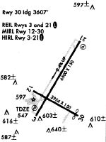
Runways
Runway Summary
| Runways: | 03/21 12/30 |
| Longest Runway: | 03/21 is 6501 ft (1982 m) long |
| Runways with an Instrument Approach: | 03 |
BWG Airport Runway Details
| Runway 03/21 | 6501 ft x 150 ft (1982 m x 46 m) | |
| Runway Length Source: | 3RD PARTY SURVEY as of 08/08/2007 | |
| Surface: | Asphalt - Good condition - No special surface treatment | |
| Runway Pavement Class: | 63 /F/C/X/T | |
| Runway Edge Lights: | High Intensity | |
Runway Weight Bearing Capacity (in thousands of pounds) |
||
| Single Wheel Landing Gear: | 120.0 | |
| Dual Wheel Landing Gear: | 221.0 | |
| Dual Tandem Wheel Landing Gear: | 358.0 | |
Runway 03 |
Runway 21 |
|
Elevation: |
547.1 | 520.4 |
Latitude: |
36-57-31.2630N | 36-58-26.9893N |
Longitude: |
086-25-30.1442W | 086-24-50.2160W |
|
Runway True Alignment: |
030 | 210 |
ILS Type: |
ILS | |
Glide Path Angle: |
3.0 degrees | 3.0 degrees |
Traffic Pattern: |
Left | Left |
Runway Markings Type: |
Precision Instrument | Nonprecision Instrument |
Runway Markings Condition: |
Fair | Fair |
Visual Glide Slope Indicators: |
4-Light PAPI On Left Side Of Runway | 4-Light PAPI On Left Side Of Runway |
REIL: |
Yes | Yes |
Threshold Crossing Height: |
44 | 30 |
| Runway 12/30 | 3956 ft x 150 ft (1206 m x 46 m) | |
| Surface: | Asphalt - Good condition - No special surface treatment | |
| Runway Pavement Class: | 9 /F/C/X/T | |
| Runway Edge Lights: | Medium Intensity | |
Runway Weight Bearing Capacity (in thousands of pounds) |
||
| Single Wheel Landing Gear: | 25.5 | |
| Dual Wheel Landing Gear: | 40.0 | |
Runway 12 |
Runway 30 |
|
Elevation: |
530.9 | 531.2 |
Latitude: |
36-57-50.6968N | 36-57-31.2069N |
Longitude: |
086-25-33.0732W | 086-24-50.8200W |
|
Runway True Alignment: |
120 | 300 |
Glide Path Angle: |
0.0 degrees | 0.0 degrees |
Traffic Pattern: |
Left | Left |
Runway Markings Type: |
Basic | Basic |
Runway Markings Condition: |
Good | Good |
Threshold Elevation: |
527.0 | |
Displaced Threshold: |
349 | |
Threshold Latitude: |
36-57-32.9236N | |
Threshold Longitude: |
086-24-54.5526W |
Services
Bulk Oxygen: |
None |
Fuel Available: |
100LL, MOGAS |
Landing Fees: |
No |
Parking: |
Hangars and tiedowns available |
Maps & Diagrams
BWG Sectional
Flight Planning
at skyvector.com
at skyvector.com