Location
Latitude: |
38-01-07.9000N (38.018861) |
Longitude: |
086-41-32.7000W (-86.692417) |
Elevation: |
659.5 feet MSL (201 m MSL) |
Magnetic Variation: |
4.4 W (as of April 2024 from WMM2020 model) |
Time Zone: |
UTC -6.0 (Standard Time) UTC -5.0 (Daylight Savings Time) |
From City: |
06 N.M. NE of Tell City, Indiana |
Found On: |
St Louis Chart |
FAA Region: |
AGL |
Contacts
Manager: |
Publicly owned: |
| KEN ROLAND 11965 OLD STATE RD 37 TELL CITY, IN 47586 812-608-0651 |
PERRY COUNTY ARPT AUTH 11965 OLD STATE RD 37 TELL CITY, IN 47586 812-547-4101 |
Operations
Airport Status: |
Operational |
Facility Use: |
Public |
Type: |
Airport |
Control tower: |
No |
Attendance (Months/Days/Hours): |
Months/Days/Hours Unattended |
Boundary ARTCC: |
ZID (Indianapolis) |
Responsible ARTCC: |
ZID (Indianapolis) |
Lighting Schedule: |
SEE RMK |
Segmented Circle Indicator: |
No |
Traffic Pattern Altitude (MSL): |
1660 feet (506 m) |
NOTAMs Facility: |
HUF |
NOTAM-D Service: |
Yes |
International Airport of Entry: |
No |
Customs Landing Rights: |
No |
Military Landing Rights: |
Yes |
Civil/Military Joint Use: |
No |
Based Aircraft
| Single Engine: | 16 |
| Multi Engine: | 2 |
Annual Operations (as of 12/31/2019)
| Total Operations: | 3241 | |
| Air Taxi: | 33 | 1.0% |
| GA Local: | 2106 | 65.0% |
| GA Itinerant: | 875 | 27.0% |
| Military Aircraft: | 227 | 7.0% |
Communications
| CTAF: | 122.700 |
| Unicom: | 122.700 |
| Approach: | EVANSVILLE 124.025 124.025 INDIANAPOLIS ARTCC |
| Departure: | EVANSVILLE 124.025 124.025 INDIANAPOLIS ARTCC |
- APCH/DEP SVC PRVDD BY INDIANAPOLIS ARTCC ON FREQS 128.3/291.625 (EVANSVILLE RCAG) WHEN EVANSVILLE APCH CTL CLSD.
Fixed Based Operators (FBOs) & Fuel
(Click on a business for detail)
Please help us keep this information up to date. This is a FREE SERVICE just like everything else on Airport Guide! If you see that a business needs to be added, modified, or deleted please fill out our Update Form.
To add, modify, or delete a business click here.
Please help us keep this information up to date. This is a FREE SERVICE just like everything else on Airport Guide! If you see that a business needs to be added, modified, or deleted please fill out our Update Form.
Area Code: 812 |
| Business Name | Frequency | Phone | Fuel Grade |
|---|---|---|---|
| Morgan Aviation
Update FBO info |
Unicom 122.7 | 836-2697 | 100LL, Jet A |
Flight Service Stations
| Primary | Alternate | |
| FSS on Field: | N | |
| FSS Name (ID): | Terre Haute(HUF) | |
| Frequency: | ||
| Toll Free Phone: | 1-800-WX-BRIEF |
Instrument Procedures / Charts
FAA Terminal Procedures valid from 0901Z 03/21/24 to 0901Z 04/18/24.
There are various types of charts available for an airport. They are listed in the Page Type column. Here is a legend for those types:
APD - Airport Diagram
DP - Departure Procedure Charts
HOT - Hot Spots
IAP - Instrument Approach Procedure Charts
MIN - Minimums
STAR - Standard Terminal Arrival Charts
| Page Type | Page Name | Volume | Action Since Last Cycle |
|---|---|---|---|
| IAP | RNAV (GPS) RWY 13 | EC-2 | |
| IAP | RNAV (GPS) RWY 31 | EC-2 | |
| MIN | TAKEOFF MINIMUMS | EC-2 |
Terminal Procedures are only available for airports in several countries with more being added all the time. If you are looking for a specific country's charts, please send an email to support(at)airportguide.com stating the country name. This will be used to prioritize the implementation.
Navigation Aids (Navaids) near KTEL
| Dist (NM) | ID | Morse Code | Name | Type | Freq | True Hdg | Mag Hdg |
|---|---|---|---|---|---|---|---|
| 0.3 | TEL | _ . . _ . . | Tell City | NDB | 206 | 159 | 163 |
| 18.7 | HNB | . . . . _ . _ . . . | Huntingburg | VOR-DME | 109.20 | 318 | 322 |
| 22.5 | MYS | _ _ _ . _ _ . . . | Mystic | VOR | 108.20 | 109 | 114 |
| 27.8 | OWB | _ _ _ . _ _ _ . . . | Owensboro | VOR-DME | 108.60 | 233 | 237 |
| 32.0 | OW | _ _ _ . _ _ | Higuy | NDB | 341 | 224 | 228 |
| 34.0 | GOI | _ _ . _ _ _ . . | Godman | NDB | 396 | 95 | 100 |
| 34.7 | FTK | . . _ . _ _ . _ | Fort Knox | VOR-DME | 109.60 | 100 | 105 |
| 39.6 | PDW | . _ _ . _ . . . _ _ | Evansville | NDB | 284 | 272 | 276 |
| 46.2 | SDF | . . . _ . . . . _ . | Louisville Standifd | VOT | 111.00 | 77 | 82 |
| 46.8 | CCT | _ . _ . _ . _ . _ | Central City | DME | 109.8 | 215 | 219 |
| 50.1 | BQM | _ . . . _ _ . _ _ _ | Bowman | DME | 112.2 | 75 | 80 |
| 50.6 | LK | . _ . . _ . _ | Laang | NDB | 414 | 81 | 86 |
| 50.7 | BFR | _ . . . . . _ . . _ . | Bedford | NDB | 344 | 13 | 18 |
| 50.9 | PXV | . _ _ . _ . . _ . . . _ | Pocket City | VORTAC | 113.30 | 264 | 268 |
| 52.4 | GMH | _ _ . _ _ . . . . | Muhlenberg | NDB | 362 | 205 | 209 |
| 52.6 | JV | . _ _ _ . . . _ | Catch | NDB | 331 | 58 | 63 |
| 52.9 | IIU | . . . . . . _ | Louisville | VORTAC | 114.80 | 84 | 89 |
| 53.5 | EWO | . . _ _ _ _ _ | New Hope | VOR-DME | 113.95 | 115 | 120 |
| 57.2 | OEA | _ _ _ . . _ | Vincennes | NDB | 251 | 315 | 319 |
| 58.1 | BRY | _ . . . . _ . _ . _ _ | Bardstown/Dcmsnd | NDB | 248 | 99 | 104 |
Nearby Airports with Fuel
Notices to Airmen (NOTAMS)
Remarks
| A110-1 | SAWRS |
| A110-2 | FOR CD CTC EVANSVILLE APCH AT 812-436-4690, WHEN APCH CLSD CTC INDIANAPOLIS ARTCC AT 317-247-2411. |
| A110-3 | SELF SERV FUEL AVBL. |
| A58-13 | TREES 15-20' TALL 100' L OF CENTERLINE |
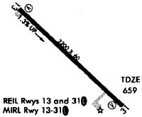
| A81-APT | ACTVT REIL RWY 13 & 31; MIRL RWY 13/31 - CTAF. PAPI RWY 13 & 31 H24. |
Runways
Runway Summary
| Runways: | 13/31 |
| Longest Runway: | 13/31 is 4400 ft (1341 m) long |
| Runways with an Instrument Approach: |
KTEL Airport Runway Details
| Runway 13/31 | 4400 ft x 75 ft (1341 m x 23 m) | |
| Runway Length Source: | 3RD PARTY SURVEY as of 03/10/2009 | |
| Surface: | Asphalt - Good condition - No special surface treatment | |
| Runway Edge Lights: | Medium Intensity | |
Runway Weight Bearing Capacity (in thousands of pounds) |
||
| Single Wheel Landing Gear: | 12.0 | |
Runway 13 |
Runway 31 |
|
Elevation: |
608.0 | 659.5 |
Latitude: |
38-01-22.9098N | 38-00-52.7939N |
Longitude: |
086-41-52.5134W | 086-41-12.8441W |
|
Runway True Alignment: |
134 | 314 |
Glide Path Angle: |
3.0 degrees | 3.2 degrees |
Traffic Pattern: |
Left | Left |
Runway Markings Type: |
Nonprecision Instrument | Nonprecision Instrument |
Runway Markings Condition: |
Good | Good |
Object at End: |
TREES | TREE |
Object Height: |
20 | 35 |
Distance from End: |
370 | 540 |
Object Centerline Offset: |
60 ft. right of centerline | 250 ft. left of centerline |
Visual Glide Slope Indicators: |
4-Light PAPI On Right Side Of Runway | 4-Light PAPI On Right Side Of Runway |
REIL: |
Yes | Yes |
Touchdown Lights: |
No | No |
Centerline Lights: |
No | No |
Threshold Crossing Height: |
29 | 30 |
Services
Airframe Repair: |
Major |
Powerplant Repair: |
Major |
Bottled Oxygen: |
None |
Bulk Oxygen: |
None |
Fuel Available: |
100LL, Jet A |
Landing Fees: |
No |
Parking: |
Hangars and tiedowns available |
Maps & Diagrams
KTEL Sectional
Flight Planning
at skyvector.com
at skyvector.com