Location
Latitude: |
37-21-29.8000N (37.358278) |
Longitude: |
085-18-33.9000W (-85.309417) |
Elevation: |
920.5 feet MSL (281 m MSL) |
Magnetic Variation: |
5.3 W (as of April 2024 from WMM2020 model) |
Time Zone: |
UTC -5.0 (Standard Time) UTC -4.0 (Daylight Savings Time) |
From City: |
02 N.M. NE of Campbellsville, Kentucky |
Found On: |
St Louis Chart |
FAA Region: |
ASO |
Contacts
Manager: |
Publicly owned: |
| CARL WATSON 360 AIRPORT ROAD CAMPBELLSVILLE, KY 42718 270-789-4182 |
AIRPORT BOARD PO BOX 1093 CAMPBELLSVILLE, KY 42719 270-403-4135 |
Operations
Airport Status: |
Operational |
Facility Use: |
Public |
Type: |
Airport |
Activation Date: |
01/1962 |
Control tower: |
No |
Attendance (Months/Days/Hours): |
Months/Days/Hours ALL/MON-FRI/0800-1700 |
Boundary ARTCC: |
ZID (Indianapolis) |
Responsible ARTCC: |
ZID (Indianapolis) |
Lighting Schedule: |
SEE RMK |
Segmented Circle Indicator: |
Yes |
Traffic Pattern Altitude (MSL): |
1920 feet (585 m) |
NOTAMs Facility: |
LOU |
NOTAM-D Service: |
Yes |
International Airport of Entry: |
No |
Customs Landing Rights: |
No |
Military Landing Rights: |
Yes |
Civil/Military Joint Use: |
No |
Based Aircraft
| Single Engine: | 14 |
Annual Operations (as of 04/04/2018)
| Total Operations: | 10330 | |
| Air Taxi: | 1410 | 13.6% |
| GA Local: | 3320 | 32.1% |
| GA Itinerant: | 4730 | 45.8% |
| Military Aircraft: | 870 | 8.4% |
Communications
| CTAF: | 122.700 |
| Unicom: | 122.700 |
| AWOS-3: | 121.125 (270-789-1985) |
- APCH/DEP SVC PRVDD BY INDIANAPOLIS ARTCC ON FREQS 121.175/353.65 (NEW HOPE RCAG).
Fixed Based Operators (FBOs) & Fuel
(Click on a business for detail)
Please help us keep this information up to date. This is a FREE SERVICE just like everything else on Airport Guide! If you see that a business needs to be added, modified, or deleted please fill out our Update Form.
To add, modify, or delete a business click here.
Please help us keep this information up to date. This is a FREE SERVICE just like everything else on Airport Guide! If you see that a business needs to be added, modified, or deleted please fill out our Update Form.
Area Code: 502 |
| Business Name | Frequency | Phone | Fuel Grade |
|---|---|---|---|
| Advantage Aviation, Inc.
Update FBO info |
Unicom 122.7 | 789-2633 | 100LL, Jet A |
Flight Service Stations
| Primary | Alternate | |
| FSS on Field: | N | |
| FSS Name (ID): | Louisville(LOU) | |
| Frequency: | ||
| Toll Free Phone: | 1-800-WX-BRIEF |
Instrument Procedures / Charts
FAA Terminal Procedures valid from 0901Z 03/21/24 to 0901Z 04/18/24.
There are various types of charts available for an airport. They are listed in the Page Type column. Here is a legend for those types:
APD - Airport Diagram
DP - Departure Procedure Charts
HOT - Hot Spots
IAP - Instrument Approach Procedure Charts
MIN - Minimums
STAR - Standard Terminal Arrival Charts
| Page Type | Page Name | Volume | Action Since Last Cycle |
|---|---|---|---|
| IAP | RNAV (GPS) RWY 05 | SE-1 | |
| IAP | RNAV (GPS) RWY 23 | SE-1 | |
| IAP | VOR/DME-A | SE-1 | |
| MIN | TAKEOFF MINIMUMS | SE-1 |
Terminal Procedures are only available for airports in several countries with more being added all the time. If you are looking for a specific country's charts, please send an email to support(at)airportguide.com stating the country name. This will be used to prioritize the implementation.
Navigation Aids (Navaids) near KAAS
| Dist (NM) | ID | Morse Code | Name | Type | Freq | True Hdg | Mag Hdg |
|---|---|---|---|---|---|---|---|
| 4.1 | TYC | _ _ . _ _ _ . _ . | Taylor County | NDB | 272 | 50 | 55 |
| 16.9 | IKY | . . _ . _ _ . _ _ | Springfield | NDB | 429 | 11 | 16 |
| 24.0 | EWO | . . _ _ _ _ _ | New Hope | VOR-DME | 113.95 | 313 | 318 |
| 29.1 | DVK | _ . . . . . _ _ . _ | Goodall | NDB | 311 | 63 | 69 |
| 30.5 | BRY | _ . . . . _ . _ . _ _ | Bardstown/Dcmsnd | NDB | 248 | 344 | 349 |
| 37.1 | CDX | _ . _ . _ . . _ . . _ | Cumberland River | NDB | 388 | 125 | 131 |
| 39.2 | BVQ | _ . . . . . . _ _ _ . _ | Beaver Creek | NDB | 260 | 238 | 243 |
| 45.6 | FTK | . . _ . _ _ . _ | Fort Knox | VOR-DME | 109.60 | 316 | 321 |
| 46.5 | IIU | . . . . . . _ | Louisville | VORTAC | 114.80 | 344 | 349 |
| 46.9 | LVT | . _ . . . . . _ _ | Livingston | VOR-DME | 114.35 | 171 | 176 |
| 48.0 | GOI | _ _ . _ _ _ . . | Godman | NDB | 396 | 318 | 323 |
| 48.7 | LE | . _ . . . | Blayd | NDB | 242 | 39 | 45 |
| 49.6 | LK | . _ . . _ . _ | Laang | NDB | 414 | 342 | 347 |
| 53.0 | FFT | . . _ . . . _ . _ | Frankfort | VOR | 109.40 | 20 | 26 |
| 53.7 | SDF | . . . _ . . . . _ . | Louisville Standifd | VOT | 111.00 | 337 | 342 |
| 54.0 | HYK | . . . . _ . _ _ _ . _ | Lexington | VOR-DME | 112.60 | 47 | 53 |
| 54.8 | MYS | _ _ _ . _ _ . . . | Mystic | VOR | 108.20 | 306 | 311 |
| 55.0 | BQM | _ . . . _ _ . _ _ _ | Bowman | DME | 112.2 | 342 | 347 |
| 59.7 | GN | _ _ . _ . | Bridl | NDB | 340 | 39 | 45 |
| 60.0 | BWG | _ . . . . _ _ _ _ . | Bowling Green | DME | 117.9 | 244 | 249 |
Nearby Airports with Fuel
Notices to Airmen (NOTAMS)
Remarks
| A11 | JOHN KERR |
| A110-2 | FOR CD CTC INDIANAPOLIS ARTCC AT 317-247-2411. |
| A17 | AFT HR - 270-403-4135/270-469-0133. |
| A30-05/23 | TREES BOTH SIDES OF RWY VIOLATE 7:1 TRSNL SFC. |
| A70-FUEL-10 | 0LL AVBL AFT HR WITH CREDIT CARD. |
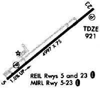
| A81-APT | ACVT REIL RWY 05 & 23; PAPI RWY 05 & 23- CTAF; MIRL RWY 05/23 PRESET ON LOW INTST; INCR INTST - CTAF. |
Runways
Runway Summary
| Runways: | 05/23 |
| Longest Runway: | 05/23 is 5003 ft (1525 m) long |
| Runways with an Instrument Approach: |
KAAS Airport Runway Details
| Runway 05/23 | 5003 ft x 75 ft (1525 m x 23 m) | |
| Runway Length Source: | 3RD PARTY SURVEY as of 12/03/2010 | |
| Surface: | Asphalt - Good condition - No special surface treatment | |
| Runway Pavement Class: | 14 /F/D/X/T | |
| Runway Edge Lights: | Medium Intensity | |
Runway Weight Bearing Capacity (in thousands of pounds) |
||
| Single Wheel Landing Gear: | 37.0 | |
| Dual Wheel Landing Gear: | 49.0 | |
Runway 05 |
Runway 23 |
|
Elevation: |
870.7 | 920.5 |
Latitude: |
37-21-13.8350N | 37-21-45.6942N |
Longitude: |
085-18-57.6316W | 085-18-10.2341W |
|
Runway True Alignment: |
050 | 230 |
Glide Path Angle: |
3.5 degrees | 3.2 degrees |
Traffic Pattern: |
Left | Left |
Runway Markings Type: |
Nonprecision Instrument | Nonprecision Instrument |
Runway Markings Condition: |
Good | Good |
Object at End: |
TREES | TREES |
Object Height: |
61 | 111 |
Distance from End: |
1143 | 3472 |
Object Centerline Offset: |
374 ft. left of centerline | 867 ft. left of centerline |
Visual Glide Slope Indicators: |
4-Light PAPI On Left Side Of Runway | 4-Light PAPI On Left Side Of Runway |
REIL: |
Yes | Yes |
Threshold Crossing Height: |
48 | 40 |
Services
Airframe Repair: |
None |
Powerplant Repair: |
None |
Bottled Oxygen: |
None |
Bulk Oxygen: |
None |
Fuel Available: |
100LL |
Landing Fees: |
No |
Parking: |
Tiedowns available |
Maps & Diagrams
KAAS Sectional
Flight Planning
at skyvector.com
at skyvector.com