Location
Latitude: |
36-24-48.6120N (36.413503) |
Longitude: |
085-18-37.6410W (-85.310456) |
Elevation: |
1372.0 feet MSL (418 m MSL) |
Magnetic Variation: |
5.2 W (as of April 2024 from WMM2020 model) |
Time Zone: |
UTC -6.0 (Standard Time) UTC -5.0 (Daylight Savings Time) |
From City: |
02 N.M. NE of Livingston, Tennessee |
Found On: |
St Louis Chart |
FAA Region: |
ASO |
Contacts
Manager: |
Publicly owned: |
| EDNA WINNINGHAM 632 AIRPORT RD LIVINGSTON, TN 38570 931-823-3671 |
CITY OF LIVINGSTON CITY HALL, 310 MCHENRY CIRCLE LIVINGSTON, TN 38570 931-823-1269 |
Operations
Airport Status: |
Operational |
Facility Use: |
Public |
Type: |
Airport |
Activation Date: |
12/1959 |
Control tower: |
No |
Attendance (Months/Days/Hours): |
Months/Days/Hours ALL/MON-FRI/0800-1700 |
Boundary ARTCC: |
ZID (Indianapolis) |
Responsible ARTCC: |
ZID (Indianapolis) |
Lighting Schedule: |
SEE RMK |
Segmented Circle Indicator: |
No |
Traffic Pattern Altitude (MSL): |
2372 feet (723 m) |
NOTAMs Facility: |
BNA |
NOTAM-D Service: |
Yes |
International Airport of Entry: |
No |
Customs Landing Rights: |
No |
Military Landing Rights: |
No |
Civil/Military Joint Use: |
No |
Based Aircraft
| Single Engine: | 14 |
| Multi Engine: | 1 |
| GA Helicopters: | 1 |
Annual Operations (as of 07/31/2018)
| Total Operations: | 4100 | |
| GA Local: | 2000 | 48.8% |
| GA Itinerant: | 2000 | 48.8% |
| Military Aircraft: | 100 | 2.4% |
Communications
| CTAF: | 122.800 |
| Unicom: | 122.800 |
| AWOS-3: | 126.175 (931-823-3329) |
- APCH/DEP SVC PRVDD BY INDIANAPOLIS ARTCC ON FREQS 124.625/371.925 (LONDON 2 RCAG).
Fixed Based Operators (FBOs) & Fuel
(Click on a business for detail)
Please help us keep this information up to date. This is a FREE SERVICE just like everything else on Airport Guide! If you see that a business needs to be added, modified, or deleted please fill out our Update Form.
To add, modify, or delete a business click here.
Please help us keep this information up to date. This is a FREE SERVICE just like everything else on Airport Guide! If you see that a business needs to be added, modified, or deleted please fill out our Update Form.
Area Code: 931 |
| Business Name | Frequency | Phone | Fuel Grade |
|---|---|---|---|
| Plane Crazy USA
Update FBO info |
Unicom 122.8 | 823-1158 | 100LL |
Flight Service Stations
| Primary | Alternate | |
| FSS on Field: | N | |
| FSS Name (ID): | Nashville(BNA) | |
| Frequency: | ||
| Toll Free Phone: | 1-800-WX-BRIEF |
Instrument Procedures / Charts
FAA Terminal Procedures valid from 0901Z 03/21/24 to 0901Z 04/18/24.
There are various types of charts available for an airport. They are listed in the Page Type column. Here is a legend for those types:
APD - Airport Diagram
DP - Departure Procedure Charts
HOT - Hot Spots
IAP - Instrument Approach Procedure Charts
MIN - Minimums
STAR - Standard Terminal Arrival Charts
| Page Type | Page Name | Volume | Action Since Last Cycle |
|---|---|---|---|
| IAP | RNAV (GPS) RWY 03 | SE-1 | Changed |
| IAP | RNAV (GPS) RWY 21 | SE-1 | Changed |
| IAP | VOR/DME RWY 21 | SE-1 | Changed |
| MIN | ALTERNATE MINIMUMS | SE-1 | |
| MIN | TAKEOFF MINIMUMS | SE-1 |
Terminal Procedures are only available for airports in several countries with more being added all the time. If you are looking for a specific country's charts, please send an email to support(at)airportguide.com stating the country name. This will be used to prioritize the implementation.
Navigation Aids (Navaids) near 8A3
| Dist (NM) | ID | Morse Code | Name | Type | Freq | True Hdg | Mag Hdg |
|---|---|---|---|---|---|---|---|
| 12.4 | LVT | . _ . . . . . _ _ | Livingston | VOR-DME | 114.35 | 34 | 39 |
| 28.8 | HEM | . . . . . _ _ | Huchn | NDB | 233 | 207 | 212 |
| 35.3 | SKN | . . . _ . _ _ . | Hurricane | NDB | 256 | 223 | 228 |
| 41.0 | BPO | _ . . . . _ _ . _ _ _ | Piney Grove | NDB | 403 | 79 | 85 |
| 41.2 | HCH | . . . . _ . _ . . . . . | Hinch Mountain | VOR-DME | 117.60 | 156 | 161 |
| 45.4 | RN | . _ . _ . | Warri | NDB | 209 | 209 | 214 |
| 46.2 | CDX | _ . _ . _ . . _ . . _ | Cumberland River | NDB | 388 | 40 | 45 |
| 49.4 | BVQ | _ . . . . . . _ _ _ . _ | Beaver Creek | NDB | 260 | 317 | 322 |
| 50.3 | JUE | . _ _ _ . . _ . | Lebanon | NDB | 414 | 254 | 259 |
| 58.1 | FQW | . . _ . _ _ . _ . _ _ | Walter Hill | NDB | 371 | 242 | 247 |
| 58.9 | DTE | _ . . _ . | Mark Anton | NDB | 394 | 161 | 166 |
| 59.4 | TYC | _ _ . _ _ _ . _ . | Taylor County | NDB | 272 | 3 | 8 |
| 62.2 | SWZ | . . . . _ _ _ _ . . | Sewart | NDB | 391 | 244 | 249 |
| 62.7 | BWG | _ . . . . _ _ _ _ . | Bowling Green | DME | 117.9 | 299 | 304 |
| 62.9 | MQY | _ _ _ _ . _ _ . _ _ | Smyrna | VOT | 110.20 | 247 | 252 |
| 62.9 | BW | _ . . . . _ _ | Noora | NDB | 236 | 296 | 301 |
| 66.1 | VI | . . . _ . . | Opery | NDB | 344 | 259 | 264 |
| 67.7 | BNA | _ . . . _ . . _ | Nashville Metropoln | VOT | 108.60 | 255 | 260 |
| 68.5 | BNA | _ . . . _ . . _ | Nashville | VORTAC | 114.10 | 256 | 261 |
| 68.7 | LOZ | . _ . . _ _ _ _ _ . . | London | VOR-DME | 116.55 | 56 | 62 |
Nearby Airports with Fuel
Notices to Airmen (NOTAMS)
Remarks
| A110-1 | SELF SVC FUEL H24 WITH CREDIT CARD. |
| A110-3 | FOR CD CTC INDIANAPOLIS ARTCC AT 317-247-2411. |
| A17 | AFT HR SVC - AMGR. |
| A57-03 | SLOPE 55:1 TO DTHR. |
| A81-APT | ACTV REIL RWY 03 & 21; PAPI RWY 21; MIRL RWY 03/21 - CTAF. |
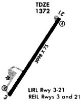
Runways
Runway Summary
| Runways: | 03/21 |
| Longest Runway: | 03/21 is 5153 ft (1571 m) long |
| Runways with an Instrument Approach: |
8A3 Airport Runway Details
| Runway 03/21 | 5153 ft x 75 ft (1571 m x 23 m) | |
| Runway Length Source: | 3RD PARTY SURVEY as of 05/26/2020 | |
| Surface: | Asphalt - Good condition - No special surface treatment | |
| Runway Pavement Class: | 11 /F/C/X/T | |
| Runway Edge Lights: | Medium Intensity | |
Runway Weight Bearing Capacity (in thousands of pounds) |
||
| Single Wheel Landing Gear: | 14.0 | |
| Dual Wheel Landing Gear: | 21.0 | |
Runway 03 |
Runway 21 |
|
Elevation: |
1365.7 | 1370.3 |
Latitude: |
36-24-27.3457N | 36-25-09.8771N |
Longitude: |
085-18-54.9932W | 085-18-20.2854W |
|
Runway True Alignment: |
033 | 213 |
Glide Path Angle: |
0.0 degrees | 4.0 degrees |
Traffic Pattern: |
Left | Left |
Runway Markings Type: |
Nonprecision Instrument | Nonprecision Instrument |
Runway Markings Condition: |
Good | Good |
Object at End: |
TREES | |
Object Height: |
19 | |
Distance from End: |
839 | |
Object Centerline Offset: |
123 ft. right of centerline | |
Visual Glide Slope Indicators: |
2-Light PAPI On Left Side Of Runway | |
REIL: |
Yes | Yes |
Threshold Crossing Height: |
39 | |
Threshold Elevation: |
1366.0 | |
Displaced Threshold: |
145 | |
Threshold Latitude: |
36-24-28.5430N | |
Threshold Longitude: |
085-18-54.0166W | |
Declared Distances |
||
Take Off Run Avbl. (TORA): |
5125 | 5007 |
Take Off Distance Avbl. (TODA): |
5152 | 5007 |
Actual Stop Dist. Avbl. (ASDA): |
5152 | 5007 |
Landing Dist. Avbl. (LDA): |
5007 | 5007 |
Services
Airframe Repair: |
Major |
Powerplant Repair: |
Major |
Bottled Oxygen: |
None |
Bulk Oxygen: |
None |
Fuel Available: |
100LL, Jet A+ |
Landing Fees: |
No |
Parking: |
Hangars and tiedowns available |
Maps & Diagrams
8A3 Sectional
Flight Planning
at skyvector.com
at skyvector.com