Location
Latitude: |
36-37-18.7140N (36.621865) |
Longitude: |
087-24-53.8120W (-87.414948) |
Elevation: |
549.9 feet MSL (168 m MSL) |
Magnetic Variation: |
3.7 W (as of April 2024 from WMM2020 model) |
Time Zone: |
UTC -6.0 (Standard Time) UTC -5.0 (Daylight Savings Time) |
From City: |
06 N.M. NW of Clarksville, Tennessee |
Found On: |
St Louis Chart |
FAA Region: |
ASO |
Contacts
Manager: |
Publicly owned: |
| JOHN PATTERSON 200 AIRPORT ROAD - BLDG 1 CLARKSVILLE, TN 37042 931-431-2080 |
CLARKSVILLE MONTGOMERY COUNTY RAA 200 A OUTLAW FIELD ROAD CLARKSVILLE, TN 37042 931-431-2080 |
Operations
Airport Status: |
Operational |
Facility Use: |
Public |
Type: |
Airport |
Activation Date: |
10/1937 |
Control tower: |
No |
Attendance (Months/Days/Hours): |
Months/Days/Hours ALL/MON-FRI/0700-1800 |
Boundary ARTCC: |
ZME (Memphis) |
Responsible ARTCC: |
ZME (Memphis) |
Lighting Schedule: |
SEE RMK |
Segmented Circle Indicator: |
Yes |
Traffic Pattern Altitude (MSL): |
1550 feet (472 m) |
NOTAMs Facility: |
CKV |
NOTAM-D Service: |
Yes |
International Airport of Entry: |
No |
Customs Landing Rights: |
No |
Military Landing Rights: |
Yes |
Civil/Military Joint Use: |
No |
Based Aircraft
| Single Engine: | 66 |
| Multi Engine: | 9 |
| Jet Engine: | 2 |
| GA Helicopters: | 10 |
Annual Operations (as of 07/01/2020)
| Total Operations: | 32475 | |
| Air Taxi: | 1000 | 3.1% |
| GA Local: | 15000 | 46.2% |
| GA Itinerant: | 11000 | 33.9% |
| Military Aircraft: | 5475 | 16.9% |
Communications
| CTAF: | 122.800 |
| Unicom: | 122.800 |
| Approach: | CAMPBELL 134.35 134.35 134.35 |
| Departure: | CAMPBELL 134.35 134.35 134.35 |
| ASOS: | 134.575 (931-431-3045) |
Fixed Based Operators (FBOs) & Fuel
(Click on a business for detail)
Please help us keep this information up to date. This is a FREE SERVICE just like everything else on Airport Guide! If you see that a business needs to be added, modified, or deleted please fill out our Update Form.
To add, modify, or delete a business click here.
Please help us keep this information up to date. This is a FREE SERVICE just like everything else on Airport Guide! If you see that a business needs to be added, modified, or deleted please fill out our Update Form.
Area Code: 931 |
| Business Name | Frequency | Phone | Fuel Grade |
|---|---|---|---|
| Aircraft Maintenance, Inc.
Update FBO info |
Unicom 122.8 | 431-3470 | 100LL, Jet A |
| Volunteer Aviation
Update FBO info |
Unicom 122.8 | 431-9900 | 100LL, Jet A |
| Volunteer Flight Training
Update FBO info |
Unicom 122.8 | 431-4170 | 100LL, Jet A |
Flight Service Stations
| Primary | Alternate | |
| FSS on Field: | N | |
| FSS Name (ID): | Jackson(MKL) | |
| Frequency: | ||
| Toll Free Phone: | 1-800-WX-BRIEF |
Instrument Procedures / Charts
FAA Terminal Procedures valid from 0901Z 03/21/24 to 0901Z 04/18/24.
There are various types of charts available for an airport. They are listed in the Page Type column. Here is a legend for those types:
APD - Airport Diagram
DP - Departure Procedure Charts
HOT - Hot Spots
IAP - Instrument Approach Procedure Charts
MIN - Minimums
STAR - Standard Terminal Arrival Charts
| Page Type | Page Name | Volume | Action Since Last Cycle |
|---|---|---|---|
| IAP | LOC RWY 35 | SE-1 | |
| IAP | RNAV (GPS) RWY 17 | SE-1 | Changed |
| IAP | RNAV (GPS) RWY 35 | SE-1 | |
| IAP | VOR RWY 35 | SE-1 | |
| MIN | ALTERNATE MINIMUMS | SE-1 | |
| MIN | TAKEOFF MINIMUMS | SE-1 |
Terminal Procedures are only available for airports in several countries with more being added all the time. If you are looking for a specific country's charts, please send an email to support(at)airportguide.com stating the country name. This will be used to prioritize the implementation.
Navigation Aids (Navaids) near CKV
| Dist (NM) | ID | Morse Code | Name | Type | Freq | True Hdg | Mag Hdg |
|---|---|---|---|---|---|---|---|
| 0.1 | CKV | _ . _ . _ . _ . . . _ | Clarksville | VOR-DME | 110.60 | 85 | 89 |
| 5.1 | HXW | . . . . _ . . _ . _ _ | Screaming Eagle | TACAN | 114.90 | 295 | 299 |
| 5.8 | CK | _ . _ . _ . _ | Snuff | NDB | 335 | 166 | 170 |
| 6.9 | FK | . . _ . _ . _ | Airbe | NDB | 273 | 0 | 4 |
| 16.0 | HIX | . . . . . . _ . . _ | Honey Grove | NDB | 356 | 13 | 17 |
| 22.9 | ON | _ _ _ _ . | Music | NDB | 279 | 114 | 118 |
| 29.7 | DMZ | _ . . _ _ _ _ . . | Dickson | NDB | 203 | 181 | 185 |
| 34.2 | AEY | . _ . _ . _ _ | Waverly | NDB | 329 | 207 | 211 |
| 38.3 | GMH | _ _ . _ _ . . . . | Muhlenberg | NDB | 362 | 18 | 22 |
| 42.5 | EU | . . . _ | Murey | NDB | 368 | 278 | 281 |
| 44.5 | VI | . . . _ . . | Opery | NDB | 344 | 124 | 128 |
| 45.7 | BNA | _ . . . _ . . _ | Nashville | VORTAC | 114.10 | 129 | 133 |
| 46.2 | CCT | _ . _ . _ . _ . _ | Central City | DME | 109.8 | 8 | 12 |
| 47.3 | GHM | _ _ . . . . . _ _ | Graham | DME | 111.6 | 182 | 186 |
| 47.5 | BW | _ . . . . _ _ | Noora | NDB | 236 | 70 | 74 |
| 47.5 | BNA | _ . . . _ . . _ | Nashville Metropoln | VOT | 108.60 | 129 | 133 |
| 50.2 | BWG | _ . . . . _ _ _ _ . | Bowling Green | DME | 117.9 | 68 | 72 |
| 53.2 | TIQ | _ . . _ _ . _ | Trainer | NDB | 410 | 245 | 248 |
| 57.3 | MQY | _ _ _ _ . _ _ . _ _ | Smyrna | VOT | 110.20 | 129 | 133 |
| 59.1 | JUE | . _ _ _ . . _ . | Lebanon | NDB | 414 | 115 | 119 |
Nearby Airports with Fuel
Notices to Airmen (NOTAMS)
Remarks
| A110-1 | EXTSV MIL & CIVIL FLIGHT TRNG WITHIN ARPT AREA. |
| A110-2 | DEER ON & INVOF ARPT. |
| A110-3 | FOR CD WHEN UNA VIA FREQ CTC CAMPBELL APCH AT 270-798-6441. |
| A17 | ARPT UNATNDD CHRISTMAS, THANKSGIVING & NEW YEAR. |
| A42-05 | PEELING & FADED. |
| A42-23 | PEELING & FADED. |
| A43-17 | PAPI RWY 17 UNUSBL BYD 9 DEGS RIGHT OF CNTLN. |
| A57-05 | APCH RATIO 12:1 TO DSPLCD THR. |
| A57-23 | APCH RATIO 19:1 TO DSPLCD THR. |
| A58-05 | FENCE 100 FT FM RWY END. |
| A58-23 | FENCE 100 FT FM RWY END. |
| A70-FUEL-10 | 0LL AFT HR SVC - 931-217-8765. |
| A81-APT | ACTVT MALS RWY 35; REIL RWY 17 - CTAF. |
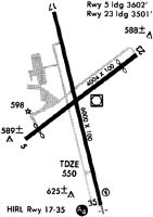
Runways
Runway Summary
| Runways: | 05/23 17/35 |
| Longest Runway: | 17/35 is 5999 ft (1828 m) long |
| Runways with an Instrument Approach: | 35 |
CKV Airport Runway Details
| Runway 05/23 | 4004 ft x 100 ft (1220 m x 30 m) | |
| Runway Length Source: | 3RD PARTY SURVEY as of 07/28/2021 | |
| Surface: | Asphalt - Fair condition - No special surface treatment | |
Runway Weight Bearing Capacity (in thousands of pounds) |
||
| Single Wheel Landing Gear: | 40.0 | |
| Dual Wheel Landing Gear: | 60.0 | |
Runway 05 |
Runway 23 |
|
Elevation: |
539.3 | 532.7 |
Latitude: |
36-37-08.6876N | 36-37-33.0345N |
Longitude: |
087-25-12.1647W | 087-24-33.4336W |
|
Runway True Alignment: |
052 | 232 |
Glide Path Angle: |
0.0 degrees | 0.0 degrees |
Traffic Pattern: |
Right | Left |
Runway Markings Type: |
Nonprecision Instrument | Nonprecision Instrument |
Runway Markings Condition: |
Poor | Poor |
Object at End: |
TREE | TREE |
Object Height: |
44 | 86 |
Distance from End: |
365 | 1057 |
Object Centerline Offset: |
63 ft. right of centerline | 28 ft. left of centerline |
Threshold Elevation: |
542.7 | 538.1 |
Displaced Threshold: |
402 | 503 |
Threshold Latitude: |
36-37-11.1348N | 36-37-29.9779N |
Threshold Longitude: |
087-25-08.2744W | 087-24-38.3021W |
Declared Distances |
||
Take Off Run Avbl. (TORA): |
4004 | 4004 |
Take Off Distance Avbl. (TODA): |
4004 | 4004 |
Actual Stop Dist. Avbl. (ASDA): |
3501 | 3602 |
Landing Dist. Avbl. (LDA): |
3099 | 3099 |
| Runway 17/35 | 5999 ft x 100 ft (1828 m x 30 m) | |
| Runway Length Source: | 3RD PARTY SURVEY as of 07/28/2021 | |
| Surface: | Asphalt - Fair condition - No special surface treatment | |
| Runway Pavement Class: | 27 /R/C/X/T | |
| Runway Edge Lights: | Medium Intensity | |
Runway Weight Bearing Capacity (in thousands of pounds) |
||
| Single Wheel Landing Gear: | 60.0 | |
| Dual Wheel Landing Gear: | 90.0 | |
Runway 17 |
Runway 35 |
|
Elevation: |
538.0 | 549.0 |
Latitude: |
36-37-46.0772N | 36-36-48.4849N |
Longitude: |
087-25-03.3029W | 087-24-45.6749W |
|
Runway True Alignment: |
166 | 346 |
ILS Type: |
LOCALIZER | |
Glide Path Angle: |
3.0 degrees | 3.0 degrees |
Traffic Pattern: |
Left | Right |
Runway Markings Type: |
Nonprecision Instrument | Nonprecision Instrument |
Runway Markings Condition: |
Good | Good |
Object at End: |
TREES | TREES |
Object Height: |
103 | 75 |
Distance from End: |
2334 | 2156 |
Object Centerline Offset: |
63 ft. right of centerline | 28 ft. left of centerline |
Visual Glide Slope Indicators: |
2-Light PAPI On Left Side Of Runway | 2-Light PAPI On Left Side Of Runway |
Approach Light System: |
1,400 Foot Medium Intensity Approach Lighting System | |
REIL: |
Yes | |
Threshold Crossing Height: |
52 | 54 |
Services
Fuel Available: |
100LL, Jet A+ |
Landing Fees: |
No |
Parking: |
Hangars and tiedowns available |
Maps & Diagrams
CKV Sectional
Flight Planning
at skyvector.com
at skyvector.com