Location
Latitude: |
37-41-09.6000N (37.686) |
Longitude: |
085-55-30.1000W (-85.925028) |
Elevation: |
775.9 feet MSL (236 m MSL) |
Magnetic Variation: |
4.9 W (as of April 2024 from WMM2020 model) |
Time Zone: |
UTC -5.0 (Standard Time) UTC -4.0 (Daylight Savings Time) |
From City: |
04 N.M. W of Elizabethtown, Kentucky |
Found On: |
St Louis Chart |
FAA Region: |
ASO |
Contacts
Manager: |
Publicly owned: |
| ROGER LAWSON 1828 KITTY HAWK DRIVE ELIZABETHTOWN, KY 42701 270-737-8388 |
ELIZABETHTOWN AIRPORT BOARD 1828 KITTY HAWK DR ELIZABETHTOWN, KY 42701 270-737-8388 |
Operations
Airport Status: |
Operational |
Facility Use: |
Public |
Type: |
Airport |
Activation Date: |
06/1982 |
Control tower: |
No |
Attendance (Months/Days/Hours): |
Months/Days/Hours ALL/MON-FRI/0800-1800 |
Boundary ARTCC: |
ZID (Indianapolis) |
Responsible ARTCC: |
ZID (Indianapolis) |
Lighting Schedule: |
SEE RMK |
Segmented Circle Indicator: |
Yes |
Traffic Pattern Altitude (MSL): |
1776 feet (541 m) |
NOTAMs Facility: |
LOU |
NOTAM-D Service: |
Yes |
Military Landing Rights: |
Yes |
Based Aircraft
| Single Engine: | 59 |
| Multi Engine: | 4 |
| GA Helicopters: | 1 |
Annual Operations (as of 12/04/2019)
| Total Operations: | 16000 | |
| Air Taxi: | 1900 | 11.9% |
| GA Local: | 5000 | 31.2% |
| GA Itinerant: | 6700 | 41.9% |
| Military Aircraft: | 2400 | 15.0% |
Communications
| CTAF: | 122.800 |
| Unicom: | 122.800 |
| Clearance Del.: | 119.45 119.45 119.45 |
| Approach: | LOUISVILLE |
| Departure: | LOUISVILLE |
| AWOS-3: | 121.025 (270-763-6433) |
Fixed Based Operators (FBOs) & Fuel
(Click on a business for detail)
Please help us keep this information up to date. This is a FREE SERVICE just like everything else on Airport Guide! If you see that a business needs to be added, modified, or deleted please fill out our Update Form.
To add, modify, or delete a business click here.
Please help us keep this information up to date. This is a FREE SERVICE just like everything else on Airport Guide! If you see that a business needs to be added, modified, or deleted please fill out our Update Form.
Area Code: 270 |
| Business Name | Frequency | Phone | Fuel Grade |
|---|---|---|---|
| Elizabethtown Flying Service, Inc.
Update FBO info |
Unicom 122.8 | 737-8388, 769-9100 | 100LL, Jet A |
Flight Service Stations
| Primary | Alternate | |
| FSS on Field: | N | |
| FSS Name (ID): | Louisville(LOU) | |
| Frequency: | ||
| Toll Free Phone: | 1-800-WX-BRIEF |
Instrument Procedures / Charts
FAA Terminal Procedures valid from 0901Z 03/21/24 to 0901Z 04/18/24.
There are various types of charts available for an airport. They are listed in the Page Type column. Here is a legend for those types:
APD - Airport Diagram
DP - Departure Procedure Charts
HOT - Hot Spots
IAP - Instrument Approach Procedure Charts
MIN - Minimums
STAR - Standard Terminal Arrival Charts
| Page Type | Page Name | Volume | Action Since Last Cycle |
|---|---|---|---|
| IAP | ILS OR LOC RWY 05 | SE-1 | |
| IAP | RNAV (GPS) RWY 05 | SE-1 | |
| IAP | RNAV (GPS) RWY 23 | SE-1 | |
| IAP | VOR-A | SE-1 | |
| MIN | ALTERNATE MINIMUMS | SE-1 | |
| MIN | TAKEOFF MINIMUMS | SE-1 |
Terminal Procedures are only available for airports in several countries with more being added all the time. If you are looking for a specific country's charts, please send an email to support(at)airportguide.com stating the country name. This will be used to prioritize the implementation.
Navigation Aids (Navaids) near EKX
| Dist (NM) | ID | Morse Code | Name | Type | Freq | True Hdg | Mag Hdg |
|---|---|---|---|---|---|---|---|
| 12.3 | EWO | . . _ _ _ _ _ | New Hope | VOR-DME | 113.95 | 105 | 110 |
| 13.5 | FTK | . . _ . _ _ . _ | Fort Knox | VOR-DME | 109.60 | 350 | 355 |
| 16.5 | GOI | _ _ . _ _ _ . . | Godman | NDB | 396 | 351 | 356 |
| 19.6 | MYS | _ _ _ . _ _ . . . | Mystic | VOR | 108.20 | 309 | 314 |
| 23.1 | BRY | _ . . . . _ . _ . _ _ | Bardstown/Dcmsnd | NDB | 248 | 65 | 70 |
| 30.0 | IIU | . . . . . . _ | Louisville | VORTAC | 114.80 | 33 | 38 |
| 30.8 | LK | . _ . . _ . _ | Laang | NDB | 414 | 26 | 31 |
| 31.4 | SDF | . . . _ . . . . _ . | Louisville Standifd | VOT | 111.00 | 16 | 21 |
| 32.8 | IKY | . . _ . _ _ . _ _ | Springfield | NDB | 429 | 95 | 100 |
| 34.9 | BQM | _ . . . _ _ . _ _ _ | Bowman | DME | 112.2 | 20 | 25 |
| 36.6 | TYC | _ _ . _ _ _ . _ . | Taylor County | NDB | 272 | 117 | 122 |
| 40.3 | BVQ | _ . . . . . . _ _ _ . _ | Beaver Creek | NDB | 260 | 185 | 190 |
| 41.3 | TEL | _ . . _ . . | Tell City | NDB | 206 | 298 | 303 |
| 48.1 | JV | . _ _ _ . . . _ | Catch | NDB | 331 | 10 | 15 |
| 51.7 | BWG | _ . . . . _ _ _ _ . | Bowling Green | DME | 117.9 | 208 | 213 |
| 55.2 | BW | _ . . . . _ _ | Noora | NDB | 236 | 208 | 213 |
| 55.6 | DVK | _ . . . . . _ _ . _ | Goodall | NDB | 311 | 96 | 101 |
| 55.9 | ABB | . _ _ . . . _ . . . | Nabb | VORTAC | 112.40 | 14 | 19 |
| 56.6 | FFT | . . _ . . . _ . _ | Frankfort | VOR | 109.40 | 57 | 62 |
| 58.9 | OW | _ _ _ . _ _ | Higuy | NDB | 341 | 267 | 271 |
Nearby Airports with Fuel
Notices to Airmen (NOTAMS)
Remarks
| A110-1 | PAJA, BIRDS ON & INVOF ARPT. |
| A110-2 | FOR CD CTC LOUISVILLE APCH AT 502-375-7499 |
| A110-3 | TWY D CLSD TO ACFT WITH WINGSPAN MORE THAN 50 FT OR MORE THAN 12500 LBS GWT. |
| A110-4 | AFT HR - 270-766-8420. FUEL AVBL H24 WITH CREDIT CARD. |
| A13 | DONALD WISE. |
| A16 | 270-769-9100. |
| A81-APT | ACTVT REIL RWY 05 & 23; MIRL RWY 05/23 - CTAF. PAPI RWY 05 & 23 OPR CONSLY. |
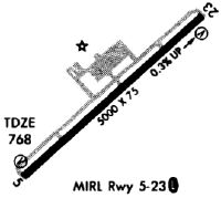
Runways
Runway Summary
| Runways: | 05/23 |
| Longest Runway: | 05/23 is 6001 ft (1829 m) long |
| Runways with an Instrument Approach: | 05 |
EKX Airport Runway Details
| Runway 05/23 | 6001 ft x 100 ft (1829 m x 30 m) | |
| Runway Length Source: | 3RD PARTY SURVEY as of 09/06/2012 | |
| Surface: | Asphalt - Good condition - No special surface treatment | |
| Runway Pavement Class: | 21 /F/C/X/T | |
| Runway Edge Lights: | Medium Intensity | |
Runway Weight Bearing Capacity (in thousands of pounds) |
||
| Single Wheel Landing Gear: | 50.0 | |
| Dual Wheel Landing Gear: | 77.0 | |
Runway 05 |
Runway 23 |
|
Elevation: |
750.4 | 775.6 |
Latitude: |
37-40-49.2481N | 37-41-29.9916N |
Longitude: |
085-55-57.2516W | 085-55-02.9963W |
|
Runway True Alignment: |
047 | 227 |
ILS Type: |
ILS/DME | |
Glide Path Angle: |
3.0 degrees | 3.0 degrees |
Runway Markings Type: |
Precision Instrument | Nonprecision Instrument |
Runway Markings Condition: |
Good | Good |
Visual Glide Slope Indicators: |
4-Light PAPI On Left Side Of Runway | 4-Light PAPI On Left Side Of Runway |
REIL: |
Yes | Yes |
Threshold Crossing Height: |
49 | 30 |
Services
Airframe Repair: |
Major |
Powerplant Repair: |
Major |
Fuel Available: |
100LL, Jet A |
Landing Fees: |
No |
Parking: |
Hangars and tiedowns available |
Maps & Diagrams
EKX Sectional
Flight Planning
at skyvector.com
at skyvector.com