Location
Latitude: |
30-53-08.5000N (30.885694) |
Longitude: |
094-02-05.8000W (-94.034944) |
Elevation: |
212.6 feet MSL (65 m MSL) |
Magnetic Variation: |
1 E (as of May 2024 from WMM2020 model) |
Time Zone: |
UTC -6.0 (Standard Time) UTC -5.0 (Daylight Savings Time) |
From City: |
04 N.M. SW of Jasper, Texas |
Found On: |
Houston Chart |
FAA Region: |
ASW |
Contacts
Manager: |
Publicly owned: |
| MARK ALLEN JASPER COUNTY COURTHOUSE, 121 N. AUSTIN ST. JASPER, TX 75951 409-384-2612 |
JASPER COUNTY 121 N. AUSTIN STREET JASPER, TX 75951 409-384-2612 |
Operations
Airport Status: |
Operational |
Facility Use: |
Public |
Type: |
Airport |
Activation Date: |
06/1951 |
Control tower: |
No |
Attendance (Months/Days/Hours): |
Months/Days/Hours ALL/ALL/0800-1700 |
Boundary ARTCC: |
ZHU (Houston) |
Responsible ARTCC: |
ZHU (Houston) |
Lighting Schedule: |
SEE RMK |
Segmented Circle Indicator: |
Yes |
Traffic Pattern Altitude (MSL): |
1213 feet (370 m) |
NOTAMs Facility: |
JAS |
NOTAM-D Service: |
Yes |
International Airport of Entry: |
No |
Customs Landing Rights: |
No |
Military Landing Rights: |
Yes |
Civil/Military Joint Use: |
No |
Based Aircraft
| Single Engine: | 12 |
Annual Operations (as of 04/02/2019)
| Total Operations: | 16000 | |
| GA Local: | 12000 | 75.0% |
| GA Itinerant: | 4000 | 25.0% |
Communications
| CTAF: | 122.800 |
| Unicom: | 122.800 |
| AWOS-3: | 118.375 (409-489-1603) |
- COMMUNICATIONS PRVDD BY MONTGOMERY COUNTY RADIO ON FREQ 122.5 (JASPER RCO).
- APCH/DEP CTL SVC PRVDD BY HOUSTON ARTCC (ZHU) ON FREQS 126.95/363.05 (LUFKIN RCAG).
Fixed Based Operators (FBOs) & Fuel
(Click on a business for detail)
Please help us keep this information up to date. This is a FREE SERVICE just like everything else on Airport Guide! If you see that a business needs to be added, modified, or deleted please fill out our Update Form.
To add, modify, or delete a business click here.
Please help us keep this information up to date. This is a FREE SERVICE just like everything else on Airport Guide! If you see that a business needs to be added, modified, or deleted please fill out our Update Form.
Area Code: 409 |
| Business Name | Frequency | Phone | Fuel Grade |
|---|
Flight Service Stations
| Primary | Alternate | |
| FSS on Field: | N | |
| FSS Name (ID): | Montgomery County(CXO) | |
| Frequency: | ||
| Toll Free Phone: | 1-800-WX-BRIEF |
Instrument Procedures / Charts
FAA Terminal Procedures valid from 0901Z 05/16/24 to 0901Z 06/13/24.
There are various types of charts available for an airport. They are listed in the Page Type column. Here is a legend for those types:
APD - Airport Diagram
DP - Departure Procedure Charts
HOT - Hot Spots
IAP - Instrument Approach Procedure Charts
MIN - Minimums
STAR - Standard Terminal Arrival Charts
| Page Type | Page Name | Volume | Action Since Last Cycle |
|---|---|---|---|
| IAP | RNAV (GPS) RWY 18 | SC-5 | |
| IAP | RNAV (GPS) RWY 36 | SC-5 | |
| MIN | ALTERNATE MINIMUMS | SC-5 | |
| MIN | TAKEOFF MINIMUMS | SC-5 |
Terminal Procedures are only available for airports in several countries with more being added all the time. If you are looking for a specific country's charts, please send an email to support(at)airportguide.com stating the country name. This will be used to prioritize the implementation.
Navigation Aids (Navaids) near JAS
| Dist (NM) | ID | Morse Code | Name | Type | Freq | True Hdg | Mag Hdg |
|---|---|---|---|---|---|---|---|
| 35.0 | HRD | . . . . . _ . _ . . | Hardin County | NDB | 524 | 199 | 198 |
| 37.0 | DXB | _ . . _ . . _ _ . . . | De Ridder | NDB | 385 | 102 | 101 |
| 37.9 | VED | . . . _ . _ . . | Leesville | NDB | 247 | 69 | 68 |
| 38.8 | LFK | . _ . . . . _ . _ . _ | Lufkin | VORTAC | 112.10 | 295 | 294 |
| 39.9 | DQU | _ . . _ _ . _ . . _ | De Quincy | NDB | 410 | 132 | 131 |
| 44.0 | POE1 | . _ _ . _ _ _ . | North | FAN MARKER | 71 | 70 | |
| 44.1 | FXU | . . _ . _ . . _ . . _ | Polk | VOR | 108.40 | 71 | 70 |
| 44.6 | GUV | _ _ . . . _ . . . _ | Gator | NDB | 359 | 78 | 77 |
| 45.2 | POE | . _ _ . _ _ _ . | South | FAN MARKER | 82 | 81 | |
| 45.3 | LF | . _ . . . . _ . | Flufy | NDB | 350 | 296 | 295 |
| 48.3 | MMY | _ _ _ _ _ . _ _ | Many | NDB | 272 | 31 | 30 |
| 49.8 | GDE | _ _ . _ . . . | Goodhue | NDB | 368 | 190 | 189 |
| 50.3 | OC | _ _ _ _ . _ . | Nados | NDB | 253 | 315 | 314 |
| 50.5 | ORG | _ _ _ . _ . _ _ . | Orange | NDB | 211 | 165 | 164 |
| 52.0 | AUR | . _ . . _ . _ . | Sulphur | NDB | 278 | 142 | 141 |
| 52.3 | DAS | _ . . . _ . . . | Daisetta | VORTAC | 116.90 | 217 | 216 |
| 55.5 | CW | _ . _ . . _ _ | Mossy | NDB | 418 | 128 | 127 |
| 56.4 | BPT | _ . . . . _ _ . _ | Beaumont | VOR-DME | 114.50 | 179 | 178 |
| 57.2 | CZJ | _ . _ . _ _ . . . _ _ _ | Amason | NDB | 341 | 353 | 352 |
| 57.2 | GXD | _ _ . _ . . _ _ . . | Nacogdoches | NDB | 391 | 323 | 322 |
Nearby Airports with Fuel
Notices to Airmen (NOTAMS)
Remarks
| A110*G | THIS AIRPORT HAS BEEN SURVEYED BY THE NATIONAL GEODETIC SURVEY. |
| A110-1 | FOR CD IF UNA TO CTC ON FSS FREQ, CTC HOUSTON ARTCC AT 281-230-5622. |
| A14 | COUNTY JUDGE/AMGR. |
| A16 | ARPT FONE 409-381-8151. KEVIN HOLLOWAY, COUNTY COMMISSIONER |
| A17 | ARPT ATTENDANT AFT HRS 409-381-8151. |
| A81-APT | MIRL RWY 18/36 PRESET LOW INTST; TO INCR INTST ACTVT - CTAF. PAPI RWY 18 & 36 OPRS CONSLY. |
Runways
Runway Summary
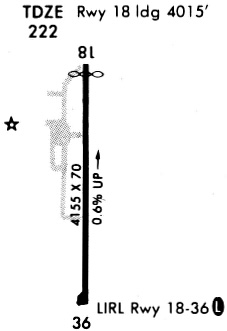
| Runways: | 18/36 |
| Longest Runway: | 18/36 is 5500 ft (1676 m) long |
| Runways with an Instrument Approach: |
JAS Airport Runway Details
| Runway 18/36 | 5500 ft x 70 ft (1676 m x 21 m) | |
| Runway Length Source: | NGS as of 01/18/2008 | |
| Surface: | Asphalt - Good condition - No special surface treatment | |
| Runway Edge Lights: | Medium Intensity | |
Runway Weight Bearing Capacity (in thousands of pounds) |
||
| Single Wheel Landing Gear: | 21.0 | |
Runway 18 |
Runway 36 |
|
Elevation: |
212.5 | 177.6 |
Latitude: |
30-53-35.7603N | 30-52-41.3330N |
Longitude: |
094-02-05.2516W | 094-02-06.2934W |
|
Runway True Alignment: |
181 | 001 |
Glide Path Angle: |
3.5 degrees | 3.5 degrees |
Traffic Pattern: |
Left | Left |
Runway Markings Type: |
Nonprecision Instrument | Nonprecision Instrument |
Runway Markings Condition: |
Good | Good |
Object at End: |
TREES | TREES |
Object Height: |
89 | 79 |
Distance from End: |
2515 | 1890 |
Object Centerline Offset: |
800 ft. left and right of centerline | 740 ft. left and right of centerline |
Visual Glide Slope Indicators: |
2-Light PAPI On Left Side Of Runway | 2-Light PAPI On Left Side Of Runway |
Threshold Crossing Height: |
41 | 45 |
Services
Airframe Repair: |
None |
Powerplant Repair: |
None |
Fuel Available: |
100LL, Jet A |
Landing Fees: |
No |
Parking: |
Hangars and tiedowns available |
Maps & Diagrams
JAS Sectional
Flight Planning
at skyvector.com
at skyvector.com