Location
Latitude: |
30-21-23.2000N (30.356444) |
Longitude: |
095-00-28.9000W (-95.008028) |
Elevation: |
150.1 feet MSL (46 m MSL) |
Magnetic Variation: |
1.6 E (as of April 2024 from WMM2020 model) |
Time Zone: |
UTC -6.0 (Standard Time) UTC -5.0 (Daylight Savings Time) |
From City: |
04 N.M. NE of Cleveland, Texas |
Found On: |
Houston Chart |
FAA Region: |
ASW |
Contacts
Manager: |
Publicly owned: |
| DICKIE HARBOUR 17699 HIGHWAY 787 W. CLEVELAND, TX 77328 281-592-1282 |
CITY OF CLEVELAND 907 E. HOUSTON ST CLEVELAND, TX 77327 281-592-2667 |
Operations
Airport Status: |
Operational |
Facility Use: |
Public |
Type: |
Airport |
Activation Date: |
11/1969 |
Control tower: |
No |
Attendance (Months/Days/Hours): |
Months/Days/Hours ALL/M-S/0800-1800 |
Boundary ARTCC: |
ZHU (Houston) |
Responsible ARTCC: |
ZHU (Houston) |
Lighting Schedule: |
SEE RMK |
Segmented Circle Indicator: |
Yes |
Traffic Pattern Altitude (MSL): |
1150 feet (351 m) |
NOTAMs Facility: |
CXO |
NOTAM-D Service: |
Yes |
International Airport of Entry: |
No |
Customs Landing Rights: |
No |
Military Landing Rights: |
Yes |
Civil/Military Joint Use: |
No |
Based Aircraft
| Single Engine: | 16 |
| Multi Engine: | 2 |
Annual Operations (as of 04/07/2023)
| Total Operations: | 23890 | |
| Air Taxi: | 10 | 0.0% |
| GA Local: | 15800 | 66.1% |
| GA Itinerant: | 7580 | 31.7% |
| Military Aircraft: | 500 | 2.1% |
Communications
| CTAF: | 123.000 |
| Unicom: | 123.000 |
| Approach: | HOUSTON |
| Departure: | HOUSTON |
| AWOS-3: | 119.325 (281-593-1754) |
Fixed Based Operators (FBOs) & Fuel
(Click on a business for detail)
Please help us keep this information up to date. This is a FREE SERVICE just like everything else on Airport Guide! If you see that a business needs to be added, modified, or deleted please fill out our Update Form.
To add, modify, or delete a business click here.
Please help us keep this information up to date. This is a FREE SERVICE just like everything else on Airport Guide! If you see that a business needs to be added, modified, or deleted please fill out our Update Form.
Area Code: 281 |
| Business Name | Frequency | Phone | Fuel Grade |
|---|---|---|---|
| Aviation Services
Update FBO info |
Unicom 123.0 | 592-1282 | 100LL |
Flight Service Stations
| Primary | Alternate | |
| FSS on Field: | N | |
| FSS Name (ID): | Montgomery County(CXO) | |
| Frequency: | ||
| Toll Free Phone: | 1-800-WX-BRIEF |
Instrument Procedures / Charts
FAA Terminal Procedures valid from 0901Z 03/21/24 to 0901Z 04/18/24.
There are various types of charts available for an airport. They are listed in the Page Type column. Here is a legend for those types:
APD - Airport Diagram
DP - Departure Procedure Charts
HOT - Hot Spots
IAP - Instrument Approach Procedure Charts
MIN - Minimums
STAR - Standard Terminal Arrival Charts
| Page Type | Page Name | Volume | Action Since Last Cycle |
|---|---|---|---|
| DP | BLTWY SEVEN (RNAV) | SC-5 | |
| DP | BORRN SIX (RNAV) | SC-5 | |
| DP | BORRN SIX (RNAV)[DELIMITER] CONT.1 | SC-5 | |
| DP | HOODO SEVEN (RNAV) | SC-5 | |
| DP | INDIE EIGHT (RNAV) | SC-5 | |
| DP | KARRR SEVEN (RNAV) | SC-5 | |
| DP | KARRR SEVEN (RNAV)[DELIMITER] CONT.1 | SC-5 | |
| DP | LURIC EIGHT (RNAV) | SC-5 | |
| DP | MMALT SEVEN (RNAV) | SC-5 | |
| DP | PALACIOS THREE | SC-5 | |
| DP | PALACIOS THREE[DELIMITER] CONT.1 | SC-5 | |
| DP | STRYA EIGHT (RNAV) | SC-5 | |
| DP | STYCK EIGHT (RNAV) | SC-5 | |
| DP | WATFO SIX (RNAV) | SC-5 | |
| DP | WYLSN EIGHT (RNAV) | SC-5 | |
| IAP | RNAV (GPS) RWY 16 | SC-5 | |
| MIN | ALTERNATE MINIMUMS | SC-5 | |
| MIN | TAKEOFF MINIMUMS | SC-5 | |
| STAR | HUDZY FOUR | SC-5 | |
| STAR | HUDZY FOUR[DELIMITER] CONT.1 | SC-5 | |
| STAR | OHIIO FOUR | SC-5 | |
| STAR | PIEGY ONE (RNAV) | SC-5 | |
| STAR | RIICE NINE | SC-5 | |
| STAR | RIICE NINE[DELIMITER] CONT.1 | SC-5 |
Terminal Procedures are only available for airports in several countries with more being added all the time. If you are looking for a specific country's charts, please send an email to support(at)airportguide.com stating the country name. This will be used to prioritize the implementation.
Navigation Aids (Navaids) near 6R3
| Dist (NM) | ID | Morse Code | Name | Type | Freq | True Hdg | Mag Hdg |
|---|---|---|---|---|---|---|---|
| 21.3 | DAS | _ . . . _ . . . | Daisetta | VORTAC | 116.90 | 117 | 116 |
| 24.3 | BVP | _ . . . . . . _ . _ _ . | Nixin | NDB | 326 | 206 | 204 |
| 24.7 | CX | _ . _ . _ . . _ | Alibi | NDB | 281 | 280 | 278 |
| 29.7 | IAH | . . . _ . . . . | Humble | VORTAC | 116.60 | 216 | 214 |
| 32.1 | DWH | _ . . . _ _ . . . . | David Hooks | NDB | 521 | 244 | 242 |
| 37.9 | UTS | . . _ _ . . . | Huntsville | NDB | 308 | 307 | 305 |
| 38.7 | HRD | . . . . . _ . _ . . | Hardin County | NDB | 524 | 91 | 90 |
| 41.4 | JPA | . _ _ _ . _ _ . . _ | Sanjac | NDB | 347 | 184 | 182 |
| 41.5 | EYQ | . _ . _ _ _ _ . _ | Weiser | NDB | 286 | 232 | 230 |
| 44.3 | HUB | . . . . . . _ _ . . . | Hobby | VOR-DME | 117.10 | 198 | 196 |
| 44.7 | GDE | _ _ . _ . . . | Goodhue | NDB | 368 | 112 | 111 |
| 44.9 | HOU | . . . . _ _ _ . . _ | Houston | VOT | 108.40 | 198 | 196 |
| 45.7 | EFD | . . . _ . _ . . | Ellington | TACAN | 109.40 | 189 | 187 |
| 50.5 | MHF | _ _ . . . . . . _ . | Trinity | VOR-DME | 114.75 | 164 | 162 |
| 50.6 | LFK | . _ . . . . _ . _ . _ | Lufkin | VORTAC | 112.10 | 17 | 16 |
| 52.6 | LF | . _ . . . . _ . | Flufy | NDB | 350 | 10 | 8 |
| 54.5 | TNV | _ _ . . . . _ | Navasota | VOR-DME | 115.90 | 265 | 263 |
| 57.0 | BPT | _ . . . . _ _ . _ | Beaumont | VOR-DME | 114.50 | 115 | 114 |
| 62.7 | GLS | _ _ . . _ . . . . . | Galveston | NDB | 206 | 167 | 165 |
| 64.5 | SBI | . . . _ . . . . . | Sabine Pass | VOR-DME | 115.40 | 128 | 127 |
Nearby Airports with Fuel
Notices to Airmen (NOTAMS)
Remarks
| A110*G | THIS AIRPORT HAS BEEN SURVEYED BY THE NATIONAL GEODETIC SURVEY. |
| A110-2 | TO ACCESS AIRPORT SECURITY GATE USE UNICOM FREQUENCY. |
| A110-3 | +25 FT TREES 260 FT WEST OF CNTRLN AT THR. |
| A110-4 | FOR SVC AFT HRS CALL 281-761-5012. |
| A110-5 | FOR CD CTC HOUSTON APCH AT 281-443-5844 TO CNL IFR CALL 281-443-5888. |
| A110-6 | RWY 16 CALM WIND RWY. |
| A58-16 | 32 FT TREES 0-199 FT DSTC,- 240 FT RIGHT. |
| A81-APT | ACTVT PAPI RWY 16 & 34; MIRL RWY 16/34 - CTAF. |
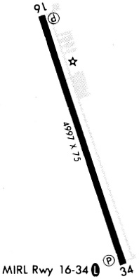
Runways
Runway Summary
| Runways: | 16/34 |
| Longest Runway: | 16/34 is 5001 ft (1524 m) long |
| Runways with an Instrument Approach: |
6R3 Airport Runway Details
| Runway 16/34 | 5001 ft x 75 ft (1524 m x 23 m) | |
| Runway Length Source: | NGS as of 11/10/2016 | |
| Surface: | Asphalt - Good condition - No special surface treatment | |
| Runway Edge Lights: | Medium Intensity | |
Runway Weight Bearing Capacity (in thousands of pounds) |
||
| Single Wheel Landing Gear: | 30.0 | |
Runway 16 |
Runway 34 |
|
Elevation: |
150.0 | 141.5 |
Latitude: |
30-21-46.6632N | 30-20-59.6829N |
Longitude: |
095-00-37.8091W | 095-00-19.9540W |
|
Runway True Alignment: |
162 | 342 |
Glide Path Angle: |
3.0 degrees | 3.0 degrees |
Traffic Pattern: |
Left | Left |
Runway Markings Type: |
Nonprecision Instrument | Nonprecision Instrument |
Runway Markings Condition: |
Good | Good |
Object at End: |
TREES | TREES |
Object Height: |
32 | 72 |
Distance from End: |
201 | 1300 |
Object Centerline Offset: |
240 ft. right of centerline | 0 ft. left and right of centerline |
Visual Glide Slope Indicators: |
4-Light PAPI On Left Side Of Runway | 4-Light PAPI On Left Side Of Runway |
Threshold Crossing Height: |
52 | 45 |
Services
Airframe Repair: |
Major |
Powerplant Repair: |
Major |
Fuel Available: |
100LL, Jet A |
Landing Fees: |
No |
Parking: |
Tiedowns available |
Maps & Diagrams
6R3 Sectional
Flight Planning
at skyvector.com
at skyvector.com