Location
Latitude: |
30-14-30.6764N (30.241854) |
Longitude: |
092-49-50.6580W (-92.830738) |
Elevation: |
18.0 feet MSL (5 m MSL) |
Magnetic Variation: |
0.3 E (as of April 2024 from WMM2020 model) |
Time Zone: |
UTC -6.0 (Standard Time) UTC -5.0 (Daylight Savings Time) |
From City: |
00 N.M. NW of Welsh, Louisiana |
Found On: |
Houston Chart |
FAA Region: |
ASW |
Contacts
Manager: |
Publicly owned: |
| KARL ARCENEAUX PO BOX 863 WELSH, LA 70591 337-570-4590 |
CITY OF WELSH PO BOX 786 WELSH, LA 70591 318-734-2231 |
Operations
Airport Status: |
Operational |
Facility Use: |
Public |
Type: |
Airport |
Activation Date: |
10/1947 |
Control tower: |
No |
Attendance (Months/Days/Hours): |
Months/Days/Hours IREG |
Boundary ARTCC: |
ZHU (Houston) |
Responsible ARTCC: |
ZHU (Houston) |
Lighting Schedule: |
SS-SR |
Segmented Circle Indicator: |
No |
Traffic Pattern Altitude (MSL): |
1018 feet (310 m) |
NOTAMs Facility: |
DRI |
NOTAM-D Service: |
Yes |
International Airport of Entry: |
No |
Customs Landing Rights: |
No |
Military Landing Rights: |
No |
Civil/Military Joint Use: |
No |
Based Aircraft
| Single Engine: | 10 |
| Ultralights: | 10 |
Annual Operations (as of 05/22/2020)
| Total Operations: | 15000 | |
| GA Local: | 10000 | 66.7% |
| GA Itinerant: | 5000 | 33.3% |
Communications
| CTAF: | 122.800 |
| Unicom: | 122.800 |
| Approach: | LAKE CHARLES 119.8 119.8 HOUSTON ARTCC |
| Departure: | LAKE CHARLES 119.8 119.8 HOUSTON ARTCC |
- APCH/DEP SVC PRVDD BY HOUSTON ARTCC (ZHU) ON FREQS 124.7/317.4 (LAKE CHARLES RCAG) WHEN LAKE CHARLES APCH CTL (LCH) CLSD.
Fixed Based Operators (FBOs) & Fuel
(Click on a business for detail)
Please help us keep this information up to date. This is a FREE SERVICE just like everything else on Airport Guide! If you see that a business needs to be added, modified, or deleted please fill out our Update Form.
To add, modify, or delete a business click here.
Please help us keep this information up to date. This is a FREE SERVICE just like everything else on Airport Guide! If you see that a business needs to be added, modified, or deleted please fill out our Update Form.
Area Code: 318 |
| Business Name | Frequency | Phone | Fuel Grade |
|---|---|---|---|
| Lyon Flying Service, Inc.
Update FBO info |
734-2594, -2595, -2596 | 100LL, Jet A |
Flight Service Stations
| Primary | Alternate | |
| FSS on Field: | N | |
| FSS Name (ID): | De Ridder(DRI) | |
| Frequency: | ||
| Toll Free Phone: | 1-800-WX-BRIEF |
Instrument Procedures / Charts
FAA Terminal Procedures valid from 0901Z 03/21/24 to 0901Z 04/18/24.
There are various types of charts available for an airport. They are listed in the Page Type column. Here is a legend for those types:
APD - Airport Diagram
DP - Departure Procedure Charts
HOT - Hot Spots
IAP - Instrument Approach Procedure Charts
MIN - Minimums
STAR - Standard Terminal Arrival Charts
| Page Type | Page Name | Volume | Action Since Last Cycle |
|---|---|---|---|
| IAP | VOR/DME OR GPS RWY 07 | SC-4 | |
| MIN | TAKEOFF MINIMUMS | SC-4 |
Terminal Procedures are only available for airports in several countries with more being added all the time. If you are looking for a specific country's charts, please send an email to support(at)airportguide.com stating the country name. This will be used to prioritize the implementation.
Navigation Aids (Navaids) near 6R1
| Dist (NM) | ID | Morse Code | Name | Type | Freq | True Hdg | Mag Hdg |
|---|---|---|---|---|---|---|---|
| 15.5 | LCH | . _ . . _ . _ . . . . . | Lake Charles | VORTAC | 113.40 | 247 | 247 |
| 19.3 | CW | _ . _ . . _ _ | Mossy | NDB | 418 | 281 | 281 |
| 25.1 | LRR | . _ . . . _ . . _ . | Oakdale | NDB | 379 | 16 | 16 |
| 27.5 | ECY | . _ . _ . _ . _ _ | Duralde | NDB | 263 | 45 | 45 |
| 30.7 | AUR | . _ . . _ . _ . | Sulphur | NDB | 278 | 265 | 265 |
| 34.9 | DQU | _ . . _ _ . _ . . _ | De Quincy | NDB | 410 | 289 | 289 |
| 38.3 | BNZ | _ . . . _ . _ _ . . | Abbeville | NDB | 230 | 106 | 106 |
| 40.2 | DXB | _ . . _ . . _ _ . . . | De Ridder | NDB | 385 | 319 | 319 |
| 42.1 | LLA | . _ . . . _ . . . _ | White Lake | VOR-DME | 114.95 | 145 | 145 |
| 43.6 | LFT | . _ . . . . _ . _ | Lafayette | VORTAC | 109.80 | 93 | 93 |
| 45.3 | OPL | _ _ _ . _ _ . . _ . . | St Landry | NDB | 335 | 56 | 56 |
| 47.4 | POE | . _ _ . _ _ _ . | South | FAN MARKER | 338 | 338 | |
| 47.9 | LF | . _ . . . . _ . | Laffs | NDB | 375 | 86 | 86 |
| 48.5 | BWK | _ . . . . _ _ _ . _ | Bunkie | NDB | 397 | 39 | 39 |
| 50.6 | GUV | _ _ . . . _ . . . _ | Gator | NDB | 359 | 338 | 338 |
| 51.1 | ORG | _ _ _ . _ . _ _ . | Orange | NDB | 211 | 258 | 257 |
| 53.1 | AR | . _ . _ . | Acadi | NDB | 269 | 108 | 108 |
| 55.9 | POE1 | . _ _ . _ _ _ . | North | FAN MARKER | 339 | 339 | |
| 55.9 | FXU | . . _ . _ . . _ . . _ | Polk | VOR | 108.40 | 339 | 339 |
| 58.0 | VED | . . . _ . _ . . | Leesville | NDB | 247 | 333 | 333 |
Nearby Airports with Fuel
Notices to Airmen (NOTAMS)
Remarks
| A110*G | THIS AIRPORT HAS BEEN SURVEYED BY THE NATIONAL GEODETIC SURVEY. |
| A110-1 | TWY FM HGR TO END OF RY 25. |
| A110-2 | FOR CD CTC LAKE CHARLES APCH AT 337-480-3103, WHEN APCH CLSD CTC HOUSTON ARTCC AT 281-230-5622. |
| A33-07/25 | RWY HAS SOME SMALL LONGITUDINAL CRACKS WITH GRASS GROWTH. BLOCK CRACKS WITH GRASS GROWTH RWY 07 TURNAROUND. GRAVEL FOD PRESENT IN PLACES. |
Runways
Runway Summary
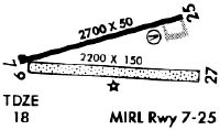
| Runways: | 07/25 09/27 |
| Longest Runway: | 07/25 is 2700 ft (823 m) long |
| Runways with an Instrument Approach: |
6R1 Airport Runway Details
| Runway 07/25 | 2700 ft x 50 ft (823 m x 15 m) | |
| Surface: | Asphalt - Fair condition - No special surface treatment | |
| Runway Edge Lights: | Medium Intensity | |
Runway Weight Bearing Capacity (in thousands of pounds) |
||
| Single Wheel Landing Gear: | 6.0 | |
Runway 07 |
Runway 25 |
|
Elevation: |
18.0 | 18.0 |
Latitude: |
30-14-28.7850N | 30-14-37.1870N |
Longitude: |
092-50-08.2690W | 092-49-39.0790W |
|
Runway True Alignment: |
072 | 252 |
Glide Path Angle: |
0.0 degrees | 0.0 degrees |
Traffic Pattern: |
Left | Left |
Runway Markings Type: |
Basic | Basic |
Runway Markings Condition: |
Fair | Fair |
Object at End: |
TREES | TREES |
Object Height: |
57 | 67 |
Distance from End: |
1137 | 953 |
Object Centerline Offset: |
253 ft. right of centerline | 131 ft. left of centerline |
| Runway 09/27 | 2200 ft x 150 ft (671 m x 46 m) | |
| Surface: | Asphalt - Fair condition - No special surface treatment | |
Runway 09 |
Runway 27 |
|
Elevation: |
18.0 | 18.0 |
Latitude: |
30-14-27.7440N | 30-14-27.9400N |
Longitude: |
092-49-59.5230W | 092-49-34.3900W |
|
Runway True Alignment: |
089 | 269 |
Glide Path Angle: |
0.0 degrees | 0.0 degrees |
Traffic Pattern: |
Left | Left |
Runway Markings Type: |
None | None |
Runway Markings Condition: |
Fair | Fair |
Object at End: |
TREES | TREES |
Object Height: |
55 | 51 |
Distance from End: |
204 | 367 |
Object Centerline Offset: |
253 ft. right of centerline | 131 ft. left of centerline |
Services
Fuel Available: |
100LL, Jet A |
Landing Fees: |
No |
Parking: |
Tiedowns available |
Maps & Diagrams
6R1 Sectional
Flight Planning
at skyvector.com
at skyvector.com