Location
Latitude: |
30-49-54.2020N (30.831723) |
Longitude: |
093-20-23.6960W (-93.339916) |
Elevation: |
201.8 feet MSL (62 m MSL) |
Magnetic Variation: |
0.6 E (as of April 2024 from WMM2020 model) |
Time Zone: |
UTC -6.0 (Standard Time) UTC -5.0 (Daylight Savings Time) |
From City: |
03 N.M. SW of De Ridder, Louisiana |
Found On: |
Houston Chart |
FAA Region: |
ASW |
Contacts
Manager: |
Publicly owned: |
| SAM LACK 1220 1ST AVE DERIDDER, LA 70634 337-463-8250 |
BEAUREGARD PARISH 1220 1ST AVE DERIDDER, LA 70634 337-463-8250 |
Operations
Airport Status: |
Operational |
Facility Use: |
Public |
Type: |
Airport |
Activation Date: |
04/1940 |
Control tower: |
No |
Attendance (Months/Days/Hours): |
Months/Days/Hours ALL/MON-FRI/0800-1700 |
Boundary ARTCC: |
ZHU (Houston) |
Responsible ARTCC: |
ZHU (Houston) |
Lighting Schedule: |
SEE RMK |
Segmented Circle Indicator: |
No |
Traffic Pattern Altitude (MSL): |
1202 feet (366 m) |
NOTAMs Facility: |
DRI |
NOTAM-D Service: |
Yes |
International Airport of Entry: |
No |
Customs Landing Rights: |
No |
Military Landing Rights: |
Yes |
Civil/Military Joint Use: |
No |
Based Aircraft
| Single Engine: | 22 |
| Multi Engine: | 2 |
Annual Operations (as of 10/10/2023)
| Total Operations: | 14400 | |
| GA Local: | 7200 | 50.0% |
| GA Itinerant: | 6200 | 43.1% |
| Military Aircraft: | 1000 | 6.9% |
Communications
| CTAF: | 122.800 |
| Unicom: | 122.800 |
| Approach: | POLK 123.7 123.7 |
| Departure: | POLK 123.7 123.7 |
| AWOS-3PT: | 118.225 (337-463-8278) |
Fixed Based Operators (FBOs) & Fuel
(Click on a business for detail)
Please help us keep this information up to date. This is a FREE SERVICE just like everything else on Airport Guide! If you see that a business needs to be added, modified, or deleted please fill out our Update Form.
To add, modify, or delete a business click here.
Please help us keep this information up to date. This is a FREE SERVICE just like everything else on Airport Guide! If you see that a business needs to be added, modified, or deleted please fill out our Update Form.
Area Code: 318 |
| Business Name | Frequency | Phone | Fuel Grade |
|---|---|---|---|
| Beauregard Parish
Update FBO info |
Unicom 122.8 | 462-3364, 463-8250 | 100LL, Jet A |
| Steve and Son
Update FBO info |
462-2176 |
Flight Service Stations
| Primary | Alternate | |
| FSS on Field: | N | |
| FSS Name (ID): | De Ridder(DRI) | |
| Frequency: | ||
| Toll Free Phone: | 1-800-WX-BRIEF |
Instrument Procedures / Charts
FAA Terminal Procedures valid from 0901Z 03/21/24 to 0901Z 04/18/24.
There are various types of charts available for an airport. They are listed in the Page Type column. Here is a legend for those types:
APD - Airport Diagram
DP - Departure Procedure Charts
HOT - Hot Spots
IAP - Instrument Approach Procedure Charts
MIN - Minimums
STAR - Standard Terminal Arrival Charts
| Page Type | Page Name | Volume | Action Since Last Cycle |
|---|---|---|---|
| IAP | LOC RWY 36 | SC-4 | |
| IAP | NDB RWY 36 | SC-4 | |
| IAP | RNAV (GPS) RWY 18 | SC-4 | |
| IAP | RNAV (GPS) RWY 36 | SC-4 | |
| MIN | ALTERNATE MINIMUMS | SC-4 | |
| MIN | TAKEOFF MINIMUMS | SC-4 |
Terminal Procedures are only available for airports in several countries with more being added all the time. If you are looking for a specific country's charts, please send an email to support(at)airportguide.com stating the country name. This will be used to prioritize the implementation.
Navigation Aids (Navaids) near DRI
| Dist (NM) | ID | Morse Code | Name | Type | Freq | True Hdg | Mag Hdg |
|---|---|---|---|---|---|---|---|
| 4.8 | DXB | _ . . _ . . _ _ . . . | De Ridder | NDB | 385 | 176 | 175 |
| 12.7 | POE | . _ _ . _ _ _ . | South | FAN MARKER | 45 | 44 | |
| 14.2 | GUV | _ _ . . . _ . . . _ | Gator | NDB | 359 | 34 | 33 |
| 16.2 | VED | . . . _ . _ . . | Leesville | NDB | 247 | 359 | 358 |
| 17.9 | POE1 | . _ _ . _ _ _ . | North | FAN MARKER | 20 | 19 | |
| 17.9 | FXU | . . _ . _ . . _ . . _ | Polk | VOR | 108.40 | 20 | 19 |
| 24.7 | DQU | _ . . _ _ . _ . . _ | De Quincy | NDB | 410 | 195 | 194 |
| 32.4 | CW | _ . _ . . _ _ | Mossy | NDB | 418 | 166 | 165 |
| 35.5 | LRR | . _ . . . _ . . _ . | Oakdale | NDB | 379 | 108 | 108 |
| 38.2 | AUR | . _ . . _ . _ . | Sulphur | NDB | 278 | 186 | 185 |
| 43.1 | LCH | . _ . . _ . _ . . . . . | Lake Charles | VORTAC | 113.40 | 163 | 162 |
| 45.6 | MMY | _ _ _ _ _ . _ _ | Many | NDB | 272 | 346 | 345 |
| 48.8 | ECY | . _ . _ . _ . _ _ | Duralde | NDB | 263 | 109 | 109 |
| 50.1 | AEX | . _ . _ . . _ | Alexandria | VORTAC | 116.10 | 59 | 59 |
| 51.3 | OOC | _ _ _ _ _ _ _ . _ . | Natchitoches | NDB | 407 | 15 | 15 |
| 51.4 | ORG | _ _ _ . _ . _ _ . | Orange | NDB | 211 | 207 | 206 |
| 56.1 | HRD | . . . . . _ . _ . . | Hardin County | NDB | 524 | 238 | 237 |
| 57.0 | BWK | _ . . . . _ _ _ . _ | Bunkie | NDB | 397 | 87 | 87 |
| 63.6 | BPT | _ . . . . _ _ . _ | Beaumont | VOR-DME | 114.50 | 213 | 212 |
| 64.2 | GDE | _ _ . _ . . . | Goodhue | NDB | 368 | 224 | 223 |
Nearby Airports with Fuel
Notices to Airmen (NOTAMS)
Remarks
| A110-1 | FOR CD IF UNA TO CTC ON FSS FREQ, CTC POLK APCH AT 337-531-2352. |
| A17 | FOR ATTENDANT OTHER TIMES CALL 337-401-2967. |
| A42-18 | RUNWAY 18 MARKINGS FADED |
| A42-36 | RUNWAY 36 MARKINGS FADED |
| A57-14 | APCH SLP 20:1 TO DSPLCD THR. |
| A70-FUEL-10 | 0LL 100LL AVBL 24 HRS SELF SERVICE WITH CREDIT CARD. FOR JET A AFT HRS & HOLS CALL 337-401-2967. |
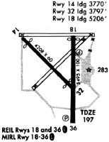
| A81-APT | REIL RWY 18 AND MIRL RWY 18/36 PRESET LOW INTST DUSK-DAWN; TO INCR INTST ACTVT - CTAF. |
Runways
Runway Summary
| Runways: | 14/32 18/36 |
| Longest Runway: | 18/36 is 5494 ft (1675 m) long |
| Runways with an Instrument Approach: | 36 |
DRI Airport Runway Details
| Runway 14/32 | 4218 ft x 60 ft (1286 m x 18 m) | |
| Runway Length Source: | 3RD PARTY SURVEY as of 05/27/2022 | |
| Surface: | Asphalt - Good condition - No special surface treatment | |
Runway 14 |
Runway 32 |
|
Elevation: |
191.5 | 192.8 |
Latitude: |
30-50-14.7993N | 30-49-45.5659N |
Longitude: |
093-20-51.2898W | 093-20-16.7542W |
|
Runway True Alignment: |
134 | 314 |
Glide Path Angle: |
0.0 degrees | 0.0 degrees |
Runway Markings Type: |
Basic | Basic |
Runway Markings Condition: |
Fair | Fair |
Object at End: |
TREES | TREES |
Object Height: |
81 | 65 |
Distance from End: |
1426 | 1635 |
Object Centerline Offset: |
163 ft. right of centerline | 114 ft. left of centerline |
Threshold Elevation: |
193.9 | |
Displaced Threshold: |
454 | |
Threshold Latitude: |
30-50-11.6525N | |
Threshold Longitude: |
093-20-47.5715W |
| Runway 18/36 | 5494 ft x 100 ft (1675 m x 30 m) | |
| Runway Length Source: | 3RD PARTY SURVEY as of 05/27/2022 | |
| Surface: | Asphalt - Good condition - Aggregate friction seal coat | |
| Runway Edge Lights: | Medium Intensity | |
Runway Weight Bearing Capacity (in thousands of pounds) |
||
| Single Wheel Landing Gear: | 60.0 | |
Runway 18 |
Runway 36 |
|
Elevation: |
201.1 | 196.7 |
Latitude: |
30-50-16.7979N | 30-49-22.4219N |
Longitude: |
093-20-16.0854W | 093-20-15.4550W |
|
Runway True Alignment: |
179 | 359 |
ILS Type: |
LOCALIZER | |
Glide Path Angle: |
3.0 degrees | 3.0 degrees |
Traffic Pattern: |
Left | Left |
Runway Markings Type: |
Nonprecision Instrument | Nonprecision Instrument |
Runway Markings Condition: |
Poor | Poor |
Object at End: |
TREES | TREES |
Object Height: |
95 | 74 |
Distance from End: |
2437 | 2169 |
Object Centerline Offset: |
163 ft. right of centerline | 114 ft. left of centerline |
Visual Glide Slope Indicators: |
4-Light PAPI On Right Side Of Runway | 4-Light PAPI On Left Side Of Runway |
Approach Light System: |
Omnidirectional Approach Lighting System | |
REIL: |
Yes | No |
Threshold Crossing Height: |
50 | 50 |
Services
Airframe Repair: |
None |
Powerplant Repair: |
None |
Bottled Oxygen: |
None |
Bulk Oxygen: |
None |
Fuel Available: |
100LL |
Landing Fees: |
No |
Parking: |
Tiedowns available |
Maps & Diagrams
DRI Sectional
Flight Planning
at skyvector.com
at skyvector.com