Location
Latitude: |
31-32-39.2900N (31.544247) |
Longitude: |
093-29-01.7000W (-93.483806) |
Elevation: |
318.5 feet MSL (97 m MSL) |
Magnetic Variation: |
0.7 E (as of April 2024 from WMM2020 model) |
Time Zone: |
UTC -6.0 (Standard Time) UTC -5.0 (Daylight Savings Time) |
From City: |
02 N.M. SW of Many, Louisiana |
Found On: |
Houston Chart |
FAA Region: |
ASW |
Contacts
Manager: |
Publicly owned: |
| MILES GREER 950 AIRPORT RD MANY, LA 71449 318-256-5857 |
CITY OF MANY PO BOX 1330 MANY, LA 71449 318-256-3651 |
Operations
Airport Status: |
Operational |
Facility Use: |
Public |
Type: |
Airport |
Activation Date: |
04/1940 |
Control tower: |
No |
Attendance (Months/Days/Hours): |
Months/Days/Hours Unattended |
Boundary ARTCC: |
ZHU (Houston) |
Responsible ARTCC: |
ZHU (Houston) |
Lighting Schedule: |
SEE RMK |
Segmented Circle Indicator: |
No |
Traffic Pattern Altitude (MSL): |
1318 feet (402 m) |
NOTAMs Facility: |
DRI |
NOTAM-D Service: |
Yes |
International Airport of Entry: |
No |
Customs Landing Rights: |
No |
Military Landing Rights: |
Yes |
Civil/Military Joint Use: |
No |
Based Aircraft
| Single Engine: | 9 |
| Multi Engine: | 1 |
Annual Operations (as of 01/30/2024)
| Total Operations: | 5100 | |
| GA Local: | 2000 | 39.2% |
| GA Itinerant: | 3000 | 58.8% |
| Military Aircraft: | 100 | 2.0% |
Communications
| CTAF: | 122.800 |
| Unicom: | 122.800 |
| Approach: | POLK 123.7 123.7 |
| Departure: | POLK 123.7 123.7 |
Fixed Based Operators (FBOs) & Fuel
(Click on a business for detail)
Please help us keep this information up to date. This is a FREE SERVICE just like everything else on Airport Guide! If you see that a business needs to be added, modified, or deleted please fill out our Update Form.
To add, modify, or delete a business click here.
Please help us keep this information up to date. This is a FREE SERVICE just like everything else on Airport Guide! If you see that a business needs to be added, modified, or deleted please fill out our Update Form.
Area Code: 318 |
| Business Name | Frequency | Phone | Fuel Grade |
|---|---|---|---|
| City of Mary
Update FBO info |
Unicom 122.8 | 256-5857 | 100LL |
Flight Service Stations
| Primary | Alternate | |
| FSS on Field: | N | |
| FSS Name (ID): | De Ridder(DRI) | |
| Frequency: | ||
| Toll Free Phone: | 1-800-WX-BRIEF |
Instrument Procedures / Charts
FAA Terminal Procedures valid from 0901Z 03/21/24 to 0901Z 04/18/24.
There are various types of charts available for an airport. They are listed in the Page Type column. Here is a legend for those types:
APD - Airport Diagram
DP - Departure Procedure Charts
HOT - Hot Spots
IAP - Instrument Approach Procedure Charts
MIN - Minimums
STAR - Standard Terminal Arrival Charts
| Page Type | Page Name | Volume | Action Since Last Cycle |
|---|---|---|---|
| IAP | RNAV (GPS) RWY 12 | SC-4 | |
| IAP | RNAV (GPS) RWY 30 | SC-4 | |
| MIN | TAKEOFF MINIMUMS | SC-4 |
Terminal Procedures are only available for airports in several countries with more being added all the time. If you are looking for a specific country's charts, please send an email to support(at)airportguide.com stating the country name. This will be used to prioritize the implementation.
Navigation Aids (Navaids) near 3R4
| Dist (NM) | ID | Morse Code | Name | Type | Freq | True Hdg | Mag Hdg |
|---|---|---|---|---|---|---|---|
| 3.4 | MMY | _ _ _ _ _ . _ _ | Many | NDB | 272 | 298 | 297 |
| 21.8 | OOC | _ _ _ _ _ _ _ . _ . | Natchitoches | NDB | 407 | 71 | 70 |
| 27.5 | VED | . . . _ . _ . . | Leesville | NDB | 247 | 164 | 163 |
| 29.3 | FXU | . . _ . _ . . _ . . _ | Polk | VOR | 108.40 | 152 | 151 |
| 29.3 | POE1 | . _ _ . _ _ _ . | North | FAN MARKER | 152 | 151 | |
| 34.3 | MSD | _ _ . . . _ . . | Mansfield | NDB | 414 | 335 | 334 |
| 34.5 | GUV | _ _ . . . _ . . . _ | Gator | NDB | 359 | 153 | 152 |
| 37.7 | POE | . _ _ . _ _ _ . | South | FAN MARKER | 154 | 153 | |
| 38.3 | CZJ | _ . _ . _ _ . . . _ _ _ | Amason | NDB | 341 | 297 | 296 |
| 48.1 | DXB | _ . . _ . . _ _ . . . | De Ridder | NDB | 385 | 170 | 169 |
| 48.5 | SWB | . . . . _ _ _ . . . | Sawmill | VOR-DME | 113.75 | 57 | 57 |
| 51.7 | EMG | . _ _ _ _ . | Elm Grove | VORTAC | 111.20 | 353 | 352 |
| 53.2 | AEX | . _ . _ . . _ | Alexandria | VORTAC | 116.10 | 108 | 108 |
| 55.4 | JBL | . _ _ _ _ . . . . _ . . | Hodge | NDB | 256 | 44 | 44 |
| 56.3 | RPF | . _ . . _ _ . . . _ . | Carthage | NDB | 332 | 312 | 311 |
| 57.1 | SHV | . . . . . . . . . . _ | Shreveport | VOT | 108.20 | 341 | 340 |
| 58.3 | BAD | _ . . . . _ _ . . | Barksdale | TACAN | 115.80 | 350 | 349 |
| 61.2 | DTN | _ . . _ _ . | Downtown | VOR | 108.60 | 347 | 346 |
| 62.7 | GXD | _ _ . _ . . _ _ . . | Nacogdoches | NDB | 391 | 276 | 275 |
| 63.3 | OC | _ _ _ _ . _ . | Nados | NDB | 253 | 267 | 266 |
Nearby Airports with Fuel
Notices to Airmen (NOTAMS)
Remarks
| A110-2 | GCO AVBL ON FREQ 135.075 THRU POLK APCH AND DE RIDDER FSS. |
| A110-3 | FOR CD CTC IF UNA VIA GCO CTC POLK APCH AT 337-531-2352. |
| A70-FUEL-10 | 0LL SELF SERVICE FUEL AVBL AFT HRS WITH CREDIT CARD. |
| A80 | BCN LCTD .44 MI FM APCH END RWY 12. |
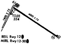
| A81-APT | DUSK-DAWN. MIRL RY 12/30, REIL RYS 12 & 30 PRESET LOW INTST DUSK-DAWN; TO INCR INTST ACTVT - CTAF. |
| E111 | PRE-DATES ACT. |
Runways
Runway Summary
| Runways: | 12/30 |
| Longest Runway: | 12/30 is 4402 ft (1342 m) long |
| Runways with an Instrument Approach: |
3R4 Airport Runway Details
| Runway 12/30 | 4402 ft x 75 ft (1342 m x 23 m) | |
| Runway Length Source: | 3RD PARTY SURVEY as of 08/26/2007 | |
| Surface: | Asphalt - Fair condition - No special surface treatment | |
| Runway Edge Lights: | Medium Intensity | |
Runway Weight Bearing Capacity (in thousands of pounds) |
||
| Single Wheel Landing Gear: | 6.0 | |
Runway 12 |
Runway 30 |
|
Elevation: |
318.3 | 307.2 |
Latitude: |
31-32-50.5090N | 31-32-28.0780N |
Longitude: |
093-29-23.5043W | 093-28-39.9048W |
|
Runway True Alignment: |
121 | 301 |
Glide Path Angle: |
3.0 degrees | 3.5 degrees |
Traffic Pattern: |
Left | Left |
Runway Markings Type: |
Nonprecision Instrument | Nonprecision Instrument |
Runway Markings Condition: |
Fair | Fair |
Object at End: |
TREES | TREES |
Object Height: |
38 | 78 |
Distance from End: |
1681 | 1830 |
Object Centerline Offset: |
227 ft. right of centerline | 0 ft. left and right of centerline |
Visual Glide Slope Indicators: |
2-Light PAPI On Left Side Of Runway | 2-Light PAPI On Left Side Of Runway |
REIL: |
Yes | Yes |
Threshold Crossing Height: |
50 | 56 |
Services
Airframe Repair: |
Minor |
Powerplant Repair: |
Minor |
Bottled Oxygen: |
None |
Bulk Oxygen: |
None |
Fuel Available: |
100LL, Jet A, MOGAS |
Landing Fees: |
No |
Parking: |
Hangars and tiedowns available |
Maps & Diagrams
3R4 Sectional
Flight Planning
at skyvector.com
at skyvector.com