Location
Latitude: |
35-32-02.9900N (35.534164) |
Longitude: |
097-38-49.3900W (-97.647053) |
Elevation: |
1299.6 feet MSL (396 m MSL) |
Magnetic Variation: |
3.2 E (as of April 2024 from WMM2020 model) |
Time Zone: |
UTC -6.0 (Standard Time) UTC -5.0 (Daylight Savings Time) |
From City: |
07 N.M. NW of Oklahoma City, Oklahoma |
Found On: |
Dallas-Ft Worth Chart |
FAA Region: |
ASW |
Contacts
Manager: |
Publicly owned: |
| KRISTY SLATER 5915 PHILIP J RHOADS RM 104 BETHANY, OK 73008 405-316-4061 |
CITY OF OKLAHOMA CITY 7100 TERMINAL DR., BOX 937 OKLAHOMA CITY, OK 73159 (405) 316-3200 |
Operations
Airport Status: |
Operational |
Facility Use: |
Public |
Type: |
Airport |
Activation Date: |
02/1943 |
Control tower: |
Yes |
Attendance (Months/Days/Hours): |
Months/Days/Hours ALL/ALL/ALL |
Boundary ARTCC: |
ZFW (Fort Worth) |
Responsible ARTCC: |
ZFW (Fort Worth) |
Lighting Schedule: |
SEE RMK |
Segmented Circle Indicator: |
Yes |
Traffic Pattern Altitude (MSL): |
2300 feet (701 m) |
NOTAMs Facility: |
PWA |
NOTAM-D Service: |
Yes |
International Airport of Entry: |
No |
Customs Landing Rights: |
No |
Military Landing Rights: |
Yes |
Civil/Military Joint Use: |
No |
Based Aircraft
| Single Engine: | 233 |
| Multi Engine: | 41 |
| Jet Engine: | 87 |
| GA Helicopters: | 11 |
Annual Operations (as of 08/31/2023)
| Total Operations: | 72302 | |
| Air Taxi: | 3891 | 5.4% |
| GA Local: | 16924 | 23.4% |
| GA Itinerant: | 47401 | 65.6% |
| Military Aircraft: | 4086 | 5.7% |
Communications
| CTAF: | 126.900 |
| Unicom: | 122.950 |
| Tower: | WILEY POST 126.9 306.9 Hrs: 0700-2200 |
| Ground: | 121.7 |
| Approach: | OKE CITY |
| Departure: | OKE CITY |
| ATIS: | 128.725 Hrs: 24 |
| ASOS: | (405-798-2013) |
| EMERG: | 121.5 |
| EMERG: | 243.0 |
Fixed Based Operators (FBOs) & Fuel
(Click on a business for detail)
Please help us keep this information up to date. This is a FREE SERVICE just like everything else on Airport Guide! If you see that a business needs to be added, modified, or deleted please fill out our Update Form.
To add, modify, or delete a business click here.
Please help us keep this information up to date. This is a FREE SERVICE just like everything else on Airport Guide! If you see that a business needs to be added, modified, or deleted please fill out our Update Form.
Area Code: 405 |
| Business Name | Frequency | Phone | Fuel Grade |
|---|---|---|---|
| FlightSafety International
Website Update FBO info |
495-6400, 800-919-8395 | ||
| Million Air Oklahoma City
Update FBO info |
Unicom 122.95, Arinc 130.6 | 787-4040, 495-5520, 800-457-0059 | 100LL, Jet A |
| Southern Wings Aircraft Sales
Update FBO info |
789-7402 | ||
| The Service Center
Update FBO info |
Arinc 129.75 | 789-5000 | 100LL, Jet A |
Flight Service Stations
| Primary | Alternate | |
| FSS on Field: | N | |
| FSS Name (ID): | Mc Alester(MLC) | |
| Frequency: | ||
| Toll Free Phone: | 1-800-WX-BRIEF |
Instrument Procedures / Charts
FAA Terminal Procedures valid from 0901Z 03/21/24 to 0901Z 04/18/24.
There are various types of charts available for an airport. They are listed in the Page Type column. Here is a legend for those types:
APD - Airport Diagram
DP - Departure Procedure Charts
HOT - Hot Spots
IAP - Instrument Approach Procedure Charts
MIN - Minimums
STAR - Standard Terminal Arrival Charts
| Page Type | Page Name | Volume | Action Since Last Cycle |
|---|---|---|---|
| APD | AIRPORT DIAGRAM | SC-1 | |
| DP | FUNNL THREE (RNAV) | SC-1 | |
| DP | KRMSN FOUR (RNAV) | SC-1 | |
| DP | MUDDE THREE (RNAV) | SC-1 | |
| DP | OLGUY THREE (RNAV) | SC-1 | |
| DP | RDHWK THREE (RNAV) | SC-1 | |
| DP | SSYKO THREE (RNAV) | SC-1 | |
| DP | STPHN THREE (RNAV) | SC-1 | |
| DP | TEBRD THREE (RNAV) | SC-1 | |
| DP | THRPE THREE (RNAV) | SC-1 | |
| DP | TRUPR THREE (RNAV) | SC-1 | |
| DP | WENDY THREE (RNAV) | SC-1 | |
| IAP | ILS OR LOC RWY 17L | SC-1 | |
| IAP | ILS OR LOC RWY 35R | SC-1 | |
| IAP | RNAV (GPS) RWY 17L | SC-1 | |
| IAP | RNAV (GPS) RWY 17R | SC-1 | |
| IAP | RNAV (GPS) RWY 35L | SC-1 | |
| IAP | RNAV (GPS) RWY 35R | SC-1 | |
| IAP | VOR RWY 17L | SC-1 | |
| IAP | VOR RWY 35R | SC-1 | |
| IAP | VOR-A | SC-1 | |
| MIN | ALTERNATE MINIMUMS | SC-1 | |
| MIN | RADAR MINIMUMS | SC-1 | |
| MIN | TAKEOFF MINIMUMS | SC-1 | |
| STAR | BASTS ONE (RNAV) | SC-1 | |
| STAR | CCASH ONE (RNAV) | SC-1 | |
| STAR | DAWKS ONE (RNAV) | SC-1 | |
| STAR | FAKEY ONE (RNAV) | SC-1 | |
| STAR | GULLI THREE | SC-1 | |
| STAR | GULLI THREE[DELIMITER] CONT.1 | SC-1 | |
| STAR | JUDDG TWO (RNAV) | SC-1 | |
| STAR | WAYMN ONE (RNAV) | SC-1 |
Terminal Procedures are only available for airports in several countries with more being added all the time. If you are looking for a specific country's charts, please send an email to support(at)airportguide.com stating the country name. This will be used to prioritize the implementation.
Navigation Aids (Navaids) near PWA
| Dist (NM) | ID | Morse Code | Name | Type | Freq | True Hdg | Mag Hdg |
|---|---|---|---|---|---|---|---|
| 0.1 | PWA | . _ _ . . _ _ . _ | Wiley Post | VOR-DME | 113.40 | 185 | 182 |
| 4.3 | OK | _ _ _ _ . _ | Tuloo | NDB | 406 | 151 | 148 |
| 10.0 | OKC | _ _ _ _ . _ _ . _ . | Oklahoma Will Rgs W | VOT | 112.15 | 167 | 164 |
| 10.7 | IRW | . . . _ . . _ _ | Will Rogers | VORTAC | 114.10 | 170 | 167 |
| 14.3 | TIK | _ . . _ . _ | Tinker | TACAN | 115.80 | 114 | 111 |
| 14.6 | RG | . _ . _ _ . | Gally | NDB | 350 | 168 | 165 |
| 19.2 | OUN | _ _ _ . . _ _ . | Norman | NDB | 370 | 153 | 150 |
| 23.8 | IFI | . . . . _ . . . | Kingfisher | TACAN | 114.70 | 313 | 310 |
| 34.8 | HN | . . . . _ . | Suybe | NDB | 264 | 98 | 95 |
| 36.5 | HMY | . . . . _ _ _ . _ _ | Muldrow | NDB | 512 | 145 | 142 |
| 42.0 | CQB | _ . _ . _ _ . _ _ . . . | Tilghman | NDB | 396 | 73 | 70 |
| 45.0 | EI | . . . | Garfy | NDB | 341 | 351 | 348 |
| 45.3 | GGU | _ _ . _ _ . . . _ | Prague | NDB | 314 | 91 | 88 |
| 47.6 | CUH | _ . _ . . . _ . . . . | Cushing | NDB | 242 | 63 | 60 |
| 49.7 | SWO | . . . . _ _ _ _ _ | Stillwater | VOR-DME | 108.40 | 33 | 30 |
| 50.1 | SRE | . . . . _ . . | Seminole | NDB | 278 | 108 | 105 |
| 50.1 | SW | . . . . _ _ | Gabeh | NDB | 255 | 32 | 29 |
| 50.4 | END | . _ . _ . . | Vance | VORTAC | 115.40 | 344 | 341 |
| 50.8 | ODG | _ _ _ _ . . _ _ . | Woodring | VOR-DME | 109.00 | 352 | 349 |
| 53.2 | PVJ | . _ _ . . . . _ . _ _ _ | Pauls Valley | NDB | 384 | 157 | 154 |
Nearby Airports with Fuel
Notices to Airmen (NOTAMS)
Remarks
| A110*G | THIS AIRPORT HAS BEEN SURVEYED BY THE NATIONAL GEODETIC SURVEY. |
| A110-10 | BIRDS ON & INVOF ARPT. |
| A110-11 | RWY 17L/35R NOISE ABATEMENT PROC IN EFCT; DEP ACFT 12500 LBS OR GTR CLIMB AT MAX RATE CONSISTENT WITH SAFETY TO 1500 FT AGL THEN REDUCE PWR & CLIMB RATE TO 3000 FT AGL OR 2 NM FM ARPT DEPENDING ON ATC & SAFETY CONDS. |
| A110-13 | EXP PONDING DURG WET COND ON RWY 17L/35R AT INT OF RWY 13/31. |
| A110-14 | SFC COND RPRTD MON-FRI 1300-2200Z. |
| A110-15 | FOR CD IFUN TO CTC GND CON, CTC OKE CITY APCH AT 405-681-5683. |
| A110-6 | RWYS 13/31, 17R/35L UNLGTD 0300-1200Z. |
| A30-13/31 | CLSD 0300-1200Z; ACFT OVR 12500 LBS GWT NA. |
| A70-FUEL-10 | 0LL 100LL AVBL H24 SELF SVC WITH CREDIT CARD. |
| A81-APT | DUSK-DAWN; WHEN ATCT CLSD ACTVT MALSR RWY 17L & 35R; HIRL RWY 17L/35R - CTAF. |
| E100 | 0400-1300Z. |
| E111 | PRE DATES THE ACT. |
| E147 | TPA RWY 17R/35L 600 FT AGL, ALL OTHER RWYS 1000 FT AGL. |
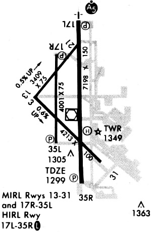
Runways
Runway Summary
| Runways: | 13/31 17L/35R 17R/35L |
| Longest Runway: | 17L/35R is 7199 ft (2194 m) long |
| Runways with an Instrument Approach: | 17L, 35R |
PWA Airport Runway Details
| Runway 13/31 | 4214 ft x 100 ft (1284 m x 30 m) | |
| Runway Length Source: | NGS as of 04/08/2008 | |
| Surface: | Concrete - Excellent condition - No special surface treatment | |
| Runway Edge Lights: | Medium Intensity | |
Runway Weight Bearing Capacity (in thousands of pounds) |
||
| Single Wheel Landing Gear: | 35.0 | |
| Dual Wheel Landing Gear: | 50.0 | |
| Dual Tandem Wheel Landing Gear: | 90.0 | |
Runway 13 |
Runway 31 |
|
Elevation: |
1270.2 | 1296.8 |
Latitude: |
35-32-06.3560N | 35-31-36.9215N |
Longitude: |
097-39-07.9001W | 097-38-31.8204W |
|
Runway True Alignment: |
135 | 315 |
Glide Path Angle: |
0.0 degrees | 0.0 degrees |
Traffic Pattern: |
Right | Left |
Runway Markings Type: |
Nonprecision Instrument | Nonprecision Instrument |
Runway Markings Condition: |
Good | Good |
Declared Distances |
||
Take Off Run Avbl. (TORA): |
4214 | 4214 |
Take Off Distance Avbl. (TODA): |
4214 | 4214 |
Actual Stop Dist. Avbl. (ASDA): |
4214 | 4214 |
Landing Dist. Avbl. (LDA): |
4214 | 4214 |
| Runway 17L/35R | 7199 ft x 150 ft (2194 m x 46 m) | |
| Runway Length Source: | NGS as of 04/08/2008 | |
| Surface: | Concrete - Excellent condition - Saw-cut or plastic grooved | |
| Runway Edge Lights: | High Intensity | |
Runway Weight Bearing Capacity (in thousands of pounds) |
||
| Single Wheel Landing Gear: | 35.0 | |
| Dual Wheel Landing Gear: | 50.0 | |
| Dual Tandem Wheel Landing Gear: | 90.0 | |
Runway 17L |
Runway 35R |
|
Elevation: |
1290.5 | 1299.6 |
Latitude: |
35-32-39.6068N | 35-31-28.4144N |
Longitude: |
097-38-43.8082W | 097-38-43.7918W |
|
Runway True Alignment: |
180 | 360 |
ILS Type: |
ILS | ILS/DME |
Glide Path Angle: |
3.0 degrees | 3.0 degrees |
Traffic Pattern: |
Right | |
Runway Markings Type: |
Precision Instrument | Precision Instrument |
Runway Markings Condition: |
Fair | Fair |
Visual Glide Slope Indicators: |
4-Light PAPI On Left Side Of Runway | 4-Light PAPI On Left Side Of Runway |
Approach Light System: |
1,400 Foot Medium Intensity Approach Lighting System With Runway Alignment Indicator Lights | 1,400 Foot Medium Intensity Approach Lighting System With Runway Alignment Indicator Lights |
REIL: |
No | |
Threshold Crossing Height: |
54 | 54 |
Threshold Elevation: |
1299.4 | |
Displaced Threshold: |
355 | |
Threshold Latitude: |
35-31-31.9287N | |
Threshold Longitude: |
097-38-43.7926W | |
Declared Distances |
||
Take Off Run Avbl. (TORA): |
7199 | 7198 |
Take Off Distance Avbl. (TODA): |
7199 | 7198 |
Actual Stop Dist. Avbl. (ASDA): |
6844 | 7198 |
Landing Dist. Avbl. (LDA): |
6844 | 6844 |
| Runway 17R/35L | 5002 ft x 75 ft (1525 m x 23 m) | |
| Runway Length Source: | NGS as of 04/08/2008 | |
| Surface: | Concrete - Excellent condition - No special surface treatment | |
| Runway Edge Lights: | Medium Intensity | |
Runway Weight Bearing Capacity (in thousands of pounds) |
||
| Single Wheel Landing Gear: | 26.0 | |
| Dual Wheel Landing Gear: | 45.0 | |
Runway 17R |
Runway 35L |
|
Elevation: |
1283.0 | 1275.4 |
Latitude: |
35-32-35.8606N | 35-31-46.3984N |
Longitude: |
097-38-57.0989W | 097-38-57.0998W |
|
Runway True Alignment: |
180 | 000 |
Glide Path Angle: |
3.0 degrees | 3.0 degrees |
Traffic Pattern: |
Right | Left |
Runway Markings Type: |
Nonprecision Instrument | Nonprecision Instrument |
Runway Markings Condition: |
Good | Good |
Visual Glide Slope Indicators: |
4-Light PAPI On Left Side Of Runway | 4-Light PAPI On Left Side Of Runway |
REIL: |
Yes | Yes |
Threshold Crossing Height: |
43 | 42 |
Declared Distances |
||
Take Off Run Avbl. (TORA): |
5002 | 5001 |
Take Off Distance Avbl. (TODA): |
5002 | 5001 |
Actual Stop Dist. Avbl. (ASDA): |
5002 | 5001 |
Landing Dist. Avbl. (LDA): |
5002 | 5001 |
Services
Airframe Repair: |
Major |
Powerplant Repair: |
Major |
Bottled Oxygen: |
None |
Bulk Oxygen: |
High Pressure / Low Pressure |
Fuel Available: |
100LL, Jet A+ |
Landing Fees: |
No |
Parking: |
Hangars and tiedowns available |
Maps & Diagrams
PWA Sectional
Flight Planning
at skyvector.com
at skyvector.com