
Location
Latitude: |
35-23-35.0665N (35.393074) |
Longitude: |
097-36-02.7422W (-97.600762) |
Elevation: |
1295.8 feet MSL (395 m MSL) |
Magnetic Variation: |
3.2 E (as of April 2024 from WMM2020 model) |
Time Zone: |
UTC -6.0 (Standard Time) UTC -5.0 (Daylight Savings Time) |
From City: |
06 N.M. SW of Oklahoma City, Oklahoma |
Found On: |
Dallas-Ft Worth Chart |
FAA Region: |
ASW |
Contacts
Manager: |
Publicly owned: |
| JEFF MULDER 7100 TERMINAL DR; BOX 937 OKLAHOMA CITY, OK 73159-0937 405-316-3260 |
OKLAHOMA CITY AIRPORT TRUST 7100 TERMINAL DR; BOX 937 OKLAHOMA CITY, OK 73159-0937 405-316-3200 |
Operations
Airport Status: |
Operational |
Facility Use: |
Public |
Type: |
Airport |
Activation Date: |
12/1938 |
Control tower: |
Yes |
Attendance (Months/Days/Hours): |
Months/Days/Hours ALL/ALL/ALL |
Boundary ARTCC: |
ZFW (Fort Worth) |
Responsible ARTCC: |
ZFW (Fort Worth) |
Lighting Schedule: |
SS-SR |
Segmented Circle Indicator: |
No |
Traffic Pattern Altitude (MSL): |
2296 feet (700 m) |
NOTAMs Facility: |
OKC |
NOTAM-D Service: |
Yes |
International Airport of Entry: |
No |
Customs Landing Rights: |
Yes |
Military Landing Rights: |
Yes |
Civil/Military Joint Use: |
No |
Aircraft Rescue and Firefighting: |
Class I ARFF Index: C Air Carrier Service: Scheduled Certification Date: 05/1973 |
Based Aircraft
| Single Engine: | 8 |
| Multi Engine: | 18 |
| Jet Engine: | 33 |
| GA Helicopters: | 12 |
| Military Aircraft: | 13 |
Annual Operations (as of 02/28/2023)
| Total Operations: | 99841 | |
| Commercial: | 43064 | 43.1% |
| Air Taxi: | 11396 | 11.4% |
| GA Local: | 14910 | 14.9% |
| GA Itinerant: | 556 | 0.6% |
| Military Aircraft: | 29915 | 30.0% |
Communications
| Tower: | ROGERS 119.35 269.45 120.25 Hrs: 24 |
| Ground: | 121.9 348.6 |
| Approach: | OKE CITY 120.45 ;081-170 124.2 ;001-080 124.6 ;171-360 266.8 ;171-360 288.325 ;081-170 336.4 ;001-080 Hrs: 24 118.95 263.075 |
| Departure: | OKE CITY 120.45 ;081-170 124.2 ;001-080 124.6 ;171-360 266.8 ;171-360 288.325 ;081-170 336.4 ;001-080 Hrs: 24 118.95 263.075 |
| ATIS: | 125.85 Hrs: 24HR. |
| ASOS: | (405-686-4711) |
| CLASS C: | 124.2 ;001-080 |
| TRUPR DP: | 124.2 |
| RIFFL RNAV STAR: | 336.4 |
| FUNNL DP: | 124.2 |
| TSDEL RNAV STAR: | 124.2 |
| ANG OPS: | 225.6 |
| CLASS C: | 288.325 ;081-170 |
| SSYKO DP: | 336.4 |
| GULLI STAR: | 124.2 |
| TEBRD DP: | 336.4 |
| KRMSN DP: | 124.2 |
| CLASS C: | 336.4 ;001-080 |
| TRUPR DP: | 336.4 |
| MURAH RNAV STAR: | 124.2 |
| CLASS C: | 124.6 ;171-360 |
| CLASS C: | 266.8 ;171-360 |
| FUNNL DP: | 336.4 |
| TSDEL RNAV STAR: | 336.4 |
| CLASS C: | 120.45 ;081-170 |
| RDHWK DP: | 124.2 |
| CAMET RNAV STAR: | 124.6 |
| CAMET RNAV STAR: | 266.8 |
| GULLI STAR: | 336.4 |
| WENDY DP: | 336.4 |
| EMERG: | 121.5 |
| RIFFL RNAV STAR: | 124.2 |
| GHOST RNAV STAR: | 124.6 |
| GHOST RNAV STAR: | 266.8 |
| KRMSN DP: | 336.4 |
| SSYKO DP: | 124.2 |
| WENDY DP: | 124.6 |
| YUCKS RNAV STAR: | 266.8 |
| MURAH RNAV STAR: | 336.4 |
| TEBRD DP: | 124.2 |
| YUCKS RNAV STAR: | 124.6 |
| RDHWK DP: | 336.4 |
Fixed Based Operators (FBOs) & Fuel
(Click on a business for detail)
Please help us keep this information up to date. This is a FREE SERVICE just like everything else on Airport Guide! If you see that a business needs to be added, modified, or deleted please fill out our Update Form.
To add, modify, or delete a business click here.
Please help us keep this information up to date. This is a FREE SERVICE just like everything else on Airport Guide! If you see that a business needs to be added, modified, or deleted please fill out our Update Form.
Area Code: 405 |
| Business Name | Frequency | Phone | Fuel Grade |
|---|---|---|---|
| AAR Oklahoma
Update FBO info |
Unicom 122.95, Arinc 130.05 | 218-3000 | 100LL, Jet A |
Flight Service Stations
| Primary | Alternate | |
| FSS on Field: | N | |
| FSS Name (ID): | Mc Alester(MLC) | |
| Frequency: | ||
| Toll Free Phone: | 1-800-WX-BRIEF |
Instrument Procedures / Charts
FAA Terminal Procedures valid from 0901Z 03/21/24 to 0901Z 04/18/24.
There are various types of charts available for an airport. They are listed in the Page Type column. Here is a legend for those types:
APD - Airport Diagram
DP - Departure Procedure Charts
HOT - Hot Spots
IAP - Instrument Approach Procedure Charts
MIN - Minimums
STAR - Standard Terminal Arrival Charts
Terminal Procedures are only available for airports in several countries with more being added all the time. If you are looking for a specific country's charts, please send an email to support(at)airportguide.com stating the country name. This will be used to prioritize the implementation.
Navigation Aids (Navaids) near OKC
| Dist (NM) | ID | Morse Code | Name | Type | Freq | True Hdg | Mag Hdg |
|---|---|---|---|---|---|---|---|
| 1.3 | OKC | _ _ _ _ . _ _ . _ . | Oklahoma Will Rgs W | VOT | 112.15 | 182 | 179 |
| 2.1 | IRW | . . . _ . . _ _ | Will Rogers | VORTAC | 114.10 | 191 | 188 |
| 4.7 | OK | _ _ _ _ . _ | Tuloo | NDB | 406 | 357 | 354 |
| 5.9 | RG | . _ . _ _ . | Gally | NDB | 350 | 174 | 171 |
| 8.7 | PWA | . _ _ . . _ _ . _ | Wiley Post | VOR-DME | 113.40 | 344 | 341 |
| 10.8 | OUN | _ _ _ . . _ _ . | Norman | NDB | 370 | 143 | 140 |
| 11.1 | TIK | _ . . _ . _ | Tinker | TACAN | 115.80 | 76 | 73 |
| 28.4 | HMY | . . . . _ _ _ . _ _ | Muldrow | NDB | 512 | 140 | 137 |
| 31.6 | IFI | . . . . _ . . . | Kingfisher | TACAN | 114.70 | 321 | 318 |
| 32.3 | HN | . . . . _ . | Suybe | NDB | 264 | 83 | 80 |
| 43.1 | CQB | _ . _ . _ _ . _ _ . . . | Tilghman | NDB | 396 | 62 | 59 |
| 43.7 | GGU | _ _ . _ _ . . . _ | Prague | NDB | 314 | 79 | 76 |
| 44.6 | PVJ | . _ _ . . . . _ . _ _ _ | Pauls Valley | NDB | 384 | 155 | 152 |
| 45.9 | SRE | . . . . _ . . | Seminole | NDB | 278 | 98 | 95 |
| 50.2 | CUH | _ . _ . . . _ . . . . | Cushing | NDB | 242 | 53 | 50 |
| 53.7 | EI | . . . | Garfy | NDB | 341 | 350 | 347 |
| 53.8 | FSI | . . _ . . . . . . | Trail | FAN MARKER | 227 | 224 | |
| 53.8 | OFZ | _ _ _ . . _ . _ _ . . | Trail | NDB | 388 | 227 | 224 |
| 55.9 | SWO | . . . . _ _ _ _ _ | Stillwater | VOR-DME | 108.40 | 26 | 23 |
| 56.4 | SW | . . . . _ _ | Gabeh | NDB | 255 | 26 | 23 |
Nearby Airports with Fuel
Notices to Airmen (NOTAMS)
Remarks
| A110-1 | RY 18/36 USED AS TWY WHEN NOT USED AS RY. |
| A110-11 | RY 18/36 VFR DALGT OPNS ONLY EXCEPT FOR AIR NATIONAL GUARD. |
| A110-12 | FLIGHT NOTIFICATION SERVICE (ADCUS) AVBL. |
| A110-13 | COMPASS ROSE RSTRD TO ACFT UNDER 95000 LBS EXCP ANG C-130. TWY B NORTH OF COMPASS ROSE RSTRD TO ACFT UNDER 120000 LBS EXCP ANG C-130. |
| A110-15 | PILOTS OF ACFT WITH WING SPANS GREATER THAN 118 FT MUST USE JUDGMENTAL OVER STEERING AT ALL TWY INTXNS. |
| A110-17 | TWYS H2 AND G EAST OF TWY H CLSD INDEFLY. |
| A110-18 | NUMEROUS BIRDS ON & INVOF ARPT. |
| A110-19 | MIL: SVC: FUEL A, A+ (405-218-3000 EXT 1) (NC-100LL). |
| A110-2 | PPR FOR PARKING ON FAA AERONAUTICAL CENTER RAMP PHONE 405-954-9783 AND EMAIL MXC@FAA.GOV. |
| A110-3 | RY 18/36 600 FT WEST OF RY 17R/35L ON EXISTING TWY. |
| A110-5 | RY 18/36; TWY G WEST OF RY 17R/35L; TWY A2 EAST OF TWY A; TWY D SW OF RY 13/31; TWYS A1; A3; A4; A6; B; AND C2 NOT AVBL FOR ACR OPNS WITH OVER 9 PSGR SEATS. |
| A110-6 | TWY G WEST OF TWY B CLSD TO ALL EXCEPT U.S. MARSHALS SERVICE ACFT. |
| A110-8 | TWY C2 CLSD TO ALL OPNS EXCEPT METRO TECH TFC. |
| A110-9 | ALL RAMPS ARE UNCONTROLLED. |
| A43-17R | PAPI UNUSBL 4 DEGS RIGHT OF RWY CNTRLN. |
| E111 | EXISTED PRIOR TO 1959. |
Runways
Runway Summary
| Runways: | 13/31 17L/35R 17R/35L 18/36 |
| Longest Runway: | 17L/35R is 9803 ft (2988 m) long |
| Runways with an Instrument Approach: | 17L, 35R, 17R, 35L |
OKC Airport Runway Details
| Runway 13/31 | 7800 ft x 150 ft (2377 m x 46 m) | |
| Runway Length Source: | 3RD PARTY SURVEY as of 03/08/2006 | |
| Surface: | Asphalt/Concrete - Fair condition - Saw-cut or plastic grooved | |
| Runway Pavement Class: | 91 /F/C/W/T | |
| Runway Edge Lights: | Medium Intensity | |
Runway Weight Bearing Capacity (in thousands of pounds) |
||
| Single Wheel Landing Gear: | 120.0 | |
| Dual Wheel Landing Gear: | 250.0 | |
| Dual Tandem Wheel Landing Gear: | 489.0 | |
Runway 13 |
Runway 31 |
|
Elevation: |
1278.7 | 1286.0 |
Latitude: |
35-24-16.5890N | 35-23-21.9774N |
Longitude: |
097-36-57.2726W | 097-35-50.7309W |
|
Runway True Alignment: |
135 | 315 |
Glide Path Angle: |
3.0 degrees | 3.0 degrees |
Traffic Pattern: |
Right | Left |
Runway Markings Type: |
Nonprecision Instrument | Nonprecision Instrument |
Runway Markings Condition: |
Good | Good |
Visual Glide Slope Indicators: |
4-Light PAPI On Left Side Of Runway | 4-Light PAPI On Left Side Of Runway |
REIL: |
Yes | Yes |
Threshold Crossing Height: |
52 | 52 |
Declared Distances |
||
Take Off Run Avbl. (TORA): |
7800 | 7800 |
Take Off Distance Avbl. (TODA): |
7800 | 7800 |
Actual Stop Dist. Avbl. (ASDA): |
7800 | 7800 |
Landing Dist. Avbl. (LDA): |
7800 | 7800 |
| Runway 17L/35R | 9803 ft x 150 ft (2988 m x 46 m) | |
| Runway Length Source: | 3RD PARTY SURVEY as of 03/08/2006 | |
| Surface: | Asphalt/Concrete - Fair condition - Saw-cut or plastic grooved | |
| Runway Pavement Class: | 98 /R/B/W/T | |
| Runway Edge Lights: | High Intensity | |
Runway Weight Bearing Capacity (in thousands of pounds) |
||
| Single Wheel Landing Gear: | 120.0 | |
| Dual Wheel Landing Gear: | 250.0 | |
| Dual Tandem Wheel Landing Gear: | 550.0 | |
Runway 17L |
Runway 35R |
|
Elevation: |
1286.8 | 1283.0 |
Latitude: |
35-24-18.5752N | 35-22-41.6296N |
Longitude: |
097-35-20.2079W | 097-35-20.1309W |
|
Runway True Alignment: |
180 | 360 |
ILS Type: |
ILS/DME | ILS/DME |
Glide Path Angle: |
0.0 degrees | 0.0 degrees |
Traffic Pattern: |
Left | Right |
Runway Markings Type: |
Precision Instrument | Precision Instrument |
Runway Markings Condition: |
Good | Good |
Runway Visual Range (RVR): |
Touchdown, Midfield, Rollout | Touchdown, Midfield, Rollout |
Approach Light System: |
1,400 Foot Medium Intensity Approach Lighting System With Runway Alignment Indicator Lights | Standard 2,400 Foot High Intensity Approach Lighting System With Sequenced Flashers, Cat. II or III Config. |
REIL: |
No | No |
Touchdown Lights: |
No | Yes |
Centerline Lights: |
Yes | Yes |
Declared Distances |
||
Take Off Run Avbl. (TORA): |
9802 | 9802 |
Take Off Distance Avbl. (TODA): |
9802 | 9802 |
Actual Stop Dist. Avbl. (ASDA): |
9802 | 9802 |
Landing Dist. Avbl. (LDA): |
9802 | 9802 |
| Runway 17R/35L | 9801 ft x 150 ft (2987 m x 46 m) | |
| Runway Length Source: | 3RD PARTY SURVEY as of 03/08/2006 | |
| Surface: | Asphalt/Concrete - Fair condition - Saw-cut or plastic grooved | |
| Runway Pavement Class: | 98 /R/B/W/T | |
| Runway Edge Lights: | High Intensity | |
Runway Weight Bearing Capacity (in thousands of pounds) |
||
| Single Wheel Landing Gear: | 120.0 | |
| Dual Wheel Landing Gear: | 250.0 | |
| Dual Tandem Wheel Landing Gear: | 550.0 | |
Runway 17R |
Runway 35L |
|
Elevation: |
1281.7 | 1263.3 |
Latitude: |
35-24-21.4168N | 35-22-44.4926N |
Longitude: |
097-36-20.6167W | 097-36-20.5280W |
|
Runway True Alignment: |
180 | 360 |
ILS Type: |
ILS/DME | ILS/DME |
Glide Path Angle: |
3.0 degrees | 0.0 degrees |
Traffic Pattern: |
Right | Left |
Runway Markings Type: |
Precision Instrument | Precision Instrument |
Runway Markings Condition: |
Good | Good |
Visual Glide Slope Indicators: |
4-Light PAPI On Left Side Of Runway | |
Runway Visual Range (RVR): |
Touchdown, Rollout | Touchdown, Rollout |
Approach Light System: |
1,400 Foot Medium Intensity Approach Lighting System With Runway Alignment Indicator Lights | 1,400 Foot Medium Intensity Approach Lighting System With Runway Alignment Indicator Lights |
REIL: |
No | No |
Centerline Lights: |
Yes | Yes |
Threshold Crossing Height: |
60 | |
Declared Distances |
||
Take Off Run Avbl. (TORA): |
9800 | 9800 |
Take Off Distance Avbl. (TODA): |
9800 | 9800 |
Actual Stop Dist. Avbl. (ASDA): |
9800 | 9800 |
Landing Dist. Avbl. (LDA): |
9800 | 9800 |
| Runway 18/36 | 3078 ft x 75 ft (938 m x 23 m) | |
| Runway Length Source: | 3RD PARTY SURVEY as of 03/08/2006 | |
| Surface: | Asphalt/Concrete - Fair condition - No special surface treatment | |
| Runway Pavement Class: | 46 /F/C/W/T | |
Runway Weight Bearing Capacity (in thousands of pounds) |
||
| Single Wheel Landing Gear: | 116.0 | |
| Dual Wheel Landing Gear: | 164.0 | |
| Dual Tandem Wheel Landing Gear: | 269.0 | |
Runway 18 |
Runway 36 |
|
Elevation: |
1274.9 | 1271.3 |
Latitude: |
35-23-36.7559N | 35-23-06.3119N |
Longitude: |
097-36-27.8186W | 097-36-27.7973W |
|
Runway True Alignment: |
180 | 360 |
Glide Path Angle: |
0.0 degrees | 0.0 degrees |
Traffic Pattern: |
Right | Left |
Runway Markings Type: |
Basic | Basic |
Runway Markings Condition: |
Good | Good |
Declared Distances |
||
Take Off Run Avbl. (TORA): |
3079 | 3079 |
Take Off Distance Avbl. (TODA): |
3079 | 3079 |
Actual Stop Dist. Avbl. (ASDA): |
3079 | 3079 |
Landing Dist. Avbl. (LDA): |
3079 | 3079 |
Services
Airframe Repair: |
Major |
Powerplant Repair: |
Major |
Bottled Oxygen: |
None |
Bulk Oxygen: |
High Pressure / Low Pressure |
Fuel Available: |
100LL, Jet A-1+ |
Landing Fees: |
No |
Parking: |
Hangars and tiedowns available |
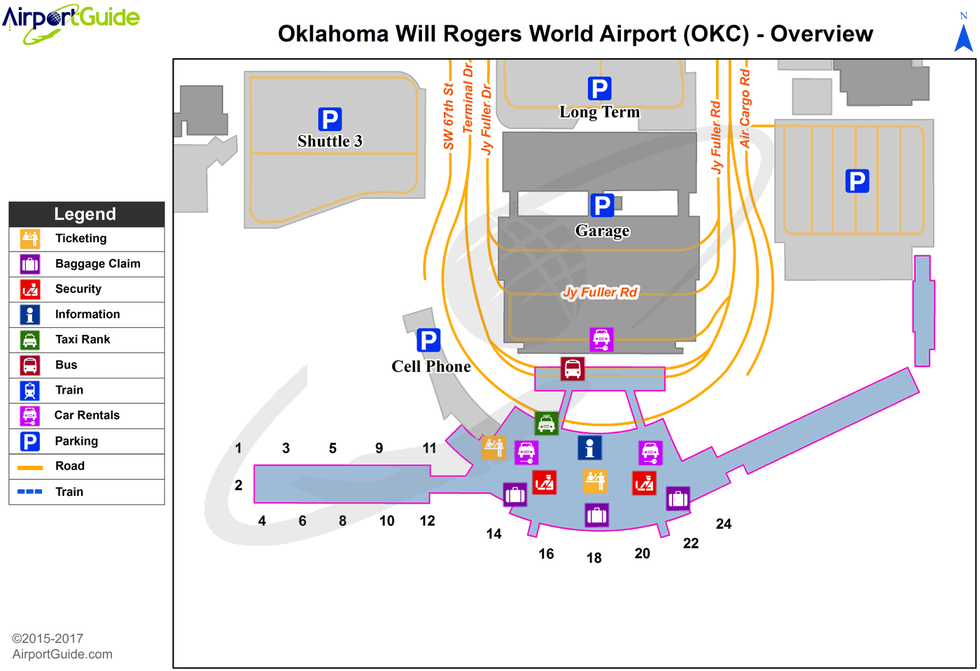
Maps & Diagrams
OKC Sectional
Flight Planning
at skyvector.com
at skyvector.com
 Diagram")