Location
Latitude: |
35-36-06.6000N (35.601833) |
Longitude: |
097-42-22.2000W (-97.706167) |
Elevation: |
1192.9 feet MSL (364 m MSL) |
Magnetic Variation: |
3.3 E (as of April 2024 from WMM2020 model) |
Time Zone: |
UTC -6.0 (Standard Time) UTC -5.0 (Daylight Savings Time) |
From City: |
12 N.M. NW of Oklahoma City, Oklahoma |
Found On: |
Dallas-Ft Worth Chart |
FAA Region: |
ASW |
Contacts
Manager: |
Privately owned: |
| JUSTIN SKAGGS 13000 N. SARA RD. YUKON, OK 73099 405-568-1663 |
HUNTER GROUP LLC 13000 N. SARA RD. YUKON, OK 73099 405-373-3886 |
Operations
Airport Status: |
Operational |
Facility Use: |
Public |
Type: |
Airport |
Control tower: |
No |
Attendance (Months/Days/Hours): |
Months/Days/Hours ALL/ALL/0800-1800 |
Boundary ARTCC: |
ZFW (Fort Worth) |
Responsible ARTCC: |
ZFW (Fort Worth) |
Lighting Schedule: |
SEE RMK |
Segmented Circle Indicator: |
No |
Traffic Pattern Altitude (MSL): |
2193 feet (668 m) |
NOTAMs Facility: |
HSD |
NOTAM-D Service: |
Yes |
Based Aircraft
| Single Engine: | 170 |
| Multi Engine: | 31 |
| Jet Engine: | 8 |
| GA Helicopters: | 1 |
Annual Operations (as of 11/04/2019)
| Total Operations: | 45425 | |
| GA Local: | 29519 | 65.0% |
| GA Itinerant: | 15896 | 35.0% |
| Military Aircraft: | 10 | 0.0% |
Communications
| CTAF: | 122.700 |
| Unicom: | 122.700 |
| Clearance Del.: | 123.7 123.7 123.7 |
| Approach: | OKE CITY |
| Departure: | OKE CITY |
| AWOS-3: | 120.975 (405-283-9848) |
Fixed Based Operators (FBOs) & Fuel
(Click on a business for detail)
Please help us keep this information up to date. This is a FREE SERVICE just like everything else on Airport Guide! If you see that a business needs to be added, modified, or deleted please fill out our Update Form.
To add, modify, or delete a business click here.
Please help us keep this information up to date. This is a FREE SERVICE just like everything else on Airport Guide! If you see that a business needs to be added, modified, or deleted please fill out our Update Form.
Area Code: 405 |
| Business Name | Frequency | Phone | Fuel Grade |
|---|---|---|---|
| Sundance Airpark
Update FBO info |
373-3886 | 100LL, Jet A |
Flight Service Stations
| Primary | Alternate | |
| FSS on Field: | N | |
| FSS Name (ID): | Mc Alester(MLC) | |
| Frequency: | ||
| Toll Free Phone: | 1-800-WX-BRIEF |
Instrument Procedures / Charts
FAA Terminal Procedures valid from 0901Z 03/21/24 to 0901Z 04/18/24.
There are various types of charts available for an airport. They are listed in the Page Type column. Here is a legend for those types:
APD - Airport Diagram
DP - Departure Procedure Charts
HOT - Hot Spots
IAP - Instrument Approach Procedure Charts
MIN - Minimums
STAR - Standard Terminal Arrival Charts
| Page Type | Page Name | Volume | Action Since Last Cycle |
|---|---|---|---|
| IAP | RNAV (GPS) RWY 18 | SC-1 | |
| IAP | RNAV (GPS) RWY 36 | SC-1 | |
| IAP | VOR RWY 18 | SC-1 | |
| MIN | ALTERNATE MINIMUMS | SC-1 | |
| MIN | TAKEOFF MINIMUMS | SC-1 | |
| STAR | GULLI THREE | SC-1 | |
| STAR | GULLI THREE[DELIMITER] CONT.1 | SC-1 |
Terminal Procedures are only available for airports in several countries with more being added all the time. If you are looking for a specific country's charts, please send an email to support(at)airportguide.com stating the country name. This will be used to prioritize the implementation.
Navigation Aids (Navaids) near KHSD
| Dist (NM) | ID | Morse Code | Name | Type | Freq | True Hdg | Mag Hdg |
|---|---|---|---|---|---|---|---|
| 5.0 | PWA | . _ _ . . _ _ . _ | Wiley Post | VOR-DME | 113.40 | 145 | 142 |
| 9.2 | OK | _ _ _ _ . _ | Tuloo | NDB | 406 | 147 | 144 |
| 14.8 | OKC | _ _ _ _ . _ _ . _ . | Oklahoma Will Rgs W | VOT | 112.15 | 159 | 156 |
| 15.3 | IRW | . . . _ . . _ _ | Will Rogers | VORTAC | 114.10 | 161 | 158 |
| 18.8 | TIK | _ . . _ . _ | Tinker | TACAN | 115.80 | 121 | 118 |
| 19.0 | IFI | . . . . _ . . . | Kingfisher | TACAN | 114.70 | 310 | 307 |
| 19.3 | RG | . _ . _ _ . | Gally | NDB | 350 | 162 | 159 |
| 24.2 | OUN | _ _ _ . . _ _ . | Norman | NDB | 370 | 151 | 148 |
| 38.4 | HN | . . . . _ . | Suybe | NDB | 264 | 103 | 100 |
| 40.6 | EI | . . . | Garfy | NDB | 341 | 354 | 351 |
| 41.5 | HMY | . . . . _ _ _ . _ _ | Muldrow | NDB | 512 | 145 | 142 |
| 43.9 | CQB | _ . _ . _ _ . _ _ . . . | Tilghman | NDB | 396 | 80 | 77 |
| 45.8 | END | . _ . _ . . | Vance | VORTAC | 115.40 | 347 | 344 |
| 46.5 | ODG | _ _ _ _ . . _ _ . | Woodring | VOR-DME | 109.00 | 355 | 352 |
| 48.1 | SWO | . . . . _ _ _ _ _ | Stillwater | VOR-DME | 108.40 | 38 | 35 |
| 48.5 | GGU | _ _ . _ _ . . . _ | Prague | NDB | 314 | 95 | 92 |
| 48.5 | SW | . . . . _ _ | Gabeh | NDB | 255 | 38 | 35 |
| 48.6 | CUH | _ . _ . . . _ . . . . | Cushing | NDB | 242 | 68 | 65 |
| 54.2 | SRE | . . . . _ . . | Seminole | NDB | 278 | 111 | 108 |
| 58.1 | PVJ | . _ _ . . . . _ . _ _ _ | Pauls Valley | NDB | 384 | 156 | 153 |
Nearby Airports with Fuel
Notices to Airmen (NOTAMS)
Remarks
| A11 | JERRY HUNTER |
| A110*G | THIS AIRPORT HAS BEEN SURVEYED BY THE NATIONAL GEODETIC SURVEY. |
| A110-1 | FOR CD CTC OKE CITY APCH AT 405-681-5683. |
| A43-18 | VASI UNUSBL BYD 7 DEGS RIGHT & LEFT OF CNTRLN. |
| A43-36 | VASI UNUSBL BYD 7 DEGS LEFT OF CNTLRN. |
| A58-36 | 10 FT RD 103 FT FM RWY END; 3 FT FENCE 65 FT FM RWY END; 17 FT TREES 120 FT FM THR 150 FT R. |
| A70-FUEL-10 | 0LL 100LL SELF SVC AVBL 24 HR WITH CREDIT CARD. |
| A73 | AVBL DURG OPS HR MON-SAT. |
| A74 | AVBL DURG OPS HR MON-SAT. |
| A81-APT | ACTVT VASI RWY 18 & 36; MIRL RWY 18/36 - CTAF. |
| E111 | CONDL - PRVDD ALL TFC PAT OPNS SHOULD BE WEST OF THE ARPT'S N/S RWY; IE. ALL TURNS TO THE LEFT WHEN LNDG OR TAKING OFF TO THE NORTH & ALL TURNS TO THE RIGHT WHEN LNDG OR TAKING OFF TO THE SOUTH; ALL EASTBOUND DEPS SHOULD ESTAB RDO CTC WITH THE WILEY POST ATCT PRIOR TO DEP. |
Runways
Runway Summary
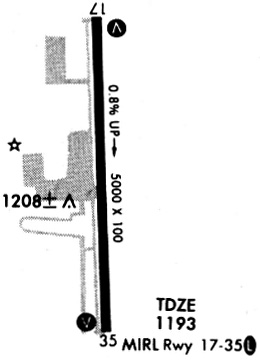
| Runways: | 18/36 |
| Longest Runway: | 18/36 is 5001 ft (1524 m) long |
| Runways with an Instrument Approach: | 18 |
KHSD Airport Runway Details
| Runway 18/36 | 5001 ft x 100 ft (1524 m x 30 m) | |
| Runway Length Source: | NGS as of 06/11/2008 | |
| Surface: | Concrete - Good condition - No special surface treatment | |
| Runway Edge Lights: | Medium Intensity | |
Runway 18 |
Runway 36 |
|
Elevation: |
1152.9 | 1192.9 |
Latitude: |
35-36-31.2952N | 35-35-41.8739N |
Longitude: |
097-42-23.2368W | 097-42-21.0908W |
|
Runway True Alignment: |
178 | 358 |
ILS Type: |
LOCALIZER | |
Glide Path Angle: |
3.0 degrees | 3.0 degrees |
Traffic Pattern: |
Right | Left |
Runway Markings Type: |
Nonprecision Instrument | Nonprecision Instrument |
Runway Markings Condition: |
Good | Good |
Object at End: |
TREES | |
Object Height: |
19 | |
Distance from End: |
382 | |
Object Centerline Offset: |
135 ft. right of centerline | |
Visual Glide Slope Indicators: |
2-Box VASI On Left Side Of Runway | 2-Box VASI On Left Side Of Runway |
Threshold Crossing Height: |
30 | 21 |
Services
Airframe Repair: |
None |
Powerplant Repair: |
None |
Bottled Oxygen: |
None |
Bulk Oxygen: |
None |
Fuel Available: |
100LL |
Landing Fees: |
No |
Parking: |
Tiedowns available |
Maps & Diagrams
KHSD Sectional
Flight Planning
at skyvector.com
at skyvector.com