Location
Latitude: |
35-05-49.7054N (35.09714) |
Longitude: |
097-58-03.6499W (-97.96768) |
Elevation: |
1151.5 feet MSL (351 m MSL) |
Magnetic Variation: |
3.4 E (as of April 2024 from WMM2020 model) |
Time Zone: |
UTC -6.0 (Standard Time) UTC -5.0 (Daylight Savings Time) |
From City: |
03 N.M. NW of Chickasha, Oklahoma |
Found On: |
Dallas-Ft Worth Chart |
FAA Region: |
ASW |
Contacts
Manager: |
Publicly owned: |
| KEITH JOHNSON CITY HALL 117 N 4TH STREET CHICKASHA, OK 73018 (405) 222-6045 |
CITY OF CHICKASHA CITY HALL 117 N 4TH STREET CHICKASHA, OK 73018 (405) 222-6020 |
Operations
Airport Status: |
Operational |
Facility Use: |
Public |
Type: |
Airport |
Activation Date: |
10/1941 |
Control tower: |
No |
Attendance (Months/Days/Hours): |
Months/Days/Hours ALL/ALL/0700-1800 |
Boundary ARTCC: |
ZFW (Fort Worth) |
Responsible ARTCC: |
ZFW (Fort Worth) |
Lighting Schedule: |
SEE RMK |
Segmented Circle Indicator: |
Yes |
Traffic Pattern Altitude (MSL): |
2152 feet (656 m) |
NOTAMs Facility: |
CHK |
NOTAM-D Service: |
Yes |
International Airport of Entry: |
No |
Customs Landing Rights: |
No |
Military Landing Rights: |
Yes |
Civil/Military Joint Use: |
No |
Based Aircraft
| Single Engine: | 21 |
| Multi Engine: | 4 |
Annual Operations (as of 07/20/2023)
| Total Operations: | 50000 | |
| GA Local: | 44000 | 88.0% |
| GA Itinerant: | 5500 | 11.0% |
| Military Aircraft: | 500 | 1.0% |
Communications
| CTAF: | 123.000 |
| Unicom: | 123.000 |
| Approach: | OKE CITY 124.6 124.6 |
| Departure: | OKE CITY 124.6 124.6 |
| AWOS-3: | 118.175 (405-574-1016) |
Fixed Based Operators (FBOs) & Fuel
(Click on a business for detail)
Please help us keep this information up to date. This is a FREE SERVICE just like everything else on Airport Guide! If you see that a business needs to be added, modified, or deleted please fill out our Update Form.
To add, modify, or delete a business click here.
Please help us keep this information up to date. This is a FREE SERVICE just like everything else on Airport Guide! If you see that a business needs to be added, modified, or deleted please fill out our Update Form.
Area Code: 405 |
| Business Name | Frequency | Phone | Fuel Grade |
|---|---|---|---|
| Chickasha Aviation Center
Update FBO info |
Unicom 123.0 | 224-8027 | 100LL, Jet A |
| Hector Flying Service
Update FBO info |
Unicom 123.0 | 224-0330 |
Flight Service Stations
| Primary | Alternate | |
| FSS on Field: | N | |
| FSS Name (ID): | Mc Alester(MLC) | |
| Frequency: | ||
| Toll Free Phone: | 1-800-WX-BRIEF |
Instrument Procedures / Charts
FAA Terminal Procedures valid from 0901Z 03/21/24 to 0901Z 04/18/24.
There are various types of charts available for an airport. They are listed in the Page Type column. Here is a legend for those types:
APD - Airport Diagram
DP - Departure Procedure Charts
HOT - Hot Spots
IAP - Instrument Approach Procedure Charts
MIN - Minimums
STAR - Standard Terminal Arrival Charts
| Page Type | Page Name | Volume | Action Since Last Cycle |
|---|---|---|---|
| IAP | RNAV (GPS) RWY 18 | SC-1 | |
| IAP | RNAV (GPS) RWY 36 | SC-1 | |
| IAP | VOR/DME-A | SC-1 | |
| MIN | TAKEOFF MINIMUMS | SC-1 | |
| STAR | GULLI THREE | SC-1 | |
| STAR | GULLI THREE[DELIMITER] CONT.1 | SC-1 |
Terminal Procedures are only available for airports in several countries with more being added all the time. If you are looking for a specific country's charts, please send an email to support(at)airportguide.com stating the country name. This will be used to prioritize the implementation.
Navigation Aids (Navaids) near CHK
| Dist (NM) | ID | Morse Code | Name | Type | Freq | True Hdg | Mag Hdg |
|---|---|---|---|---|---|---|---|
| 22.1 | RG | . _ . _ _ . | Gally | NDB | 350 | 57 | 54 |
| 23.6 | IRW | . . . _ . . _ _ | Will Rogers | VORTAC | 114.10 | 48 | 45 |
| 24.3 | OKC | _ _ _ _ . _ _ . _ . | Oklahoma Will Rgs W | VOT | 112.15 | 47 | 44 |
| 26.0 | OUN | _ _ _ . . _ _ . | Norman | NDB | 370 | 69 | 66 |
| 28.6 | OFZ | _ _ _ . . _ . _ _ . . | Trail | NDB | 388 | 228 | 224 |
| 28.6 | FSI | . . _ . . . . . . | Trail | FAN MARKER | 228 | 224 | |
| 28.6 | OK | _ _ _ _ . _ | Tuloo | NDB | 406 | 38 | 35 |
| 30.5 | PWA | . _ _ . . _ _ . _ | Wiley Post | VOR-DME | 113.40 | 30 | 27 |
| 35.3 | TIK | _ . . _ . _ | Tinker | TACAN | 115.80 | 54 | 51 |
| 36.3 | PFL | . _ _ . . . _ . . _ . . | Post | NDB | 425 | 216 | 212 |
| 36.4 | HMY | . . . . _ _ _ . _ _ | Muldrow | NDB | 512 | 96 | 93 |
| 42.2 | LAW | . _ . . . _ . _ _ | Lawton | VOR-DME | 116.85 | 211 | 207 |
| 42.5 | IFI | . . . . _ . . . | Kingfisher | TACAN | 114.70 | 357 | 354 |
| 42.8 | DUC | _ . . . . _ _ . _ . | Duncan | DME | 111 | 176 | 173 |
| 43.0 | PVJ | . _ _ . . . . _ . _ _ _ | Pauls Valley | NDB | 384 | 122 | 119 |
| 54.5 | HN | . . . . _ . | Suybe | NDB | 264 | 66 | 63 |
| 55.6 | HBR | . . . . _ . . . . _ . | Hobart | VORTAC | 111.80 | 255 | 251 |
| 61.3 | BFV | _ . . . . . _ . . . . _ | Burns Flat | VORTAC | 110.00 | 278 | 274 |
| 64.1 | BZ | _ . . . _ _ . . | Fossi | NDB | 393 | 289 | 285 |
| 64.3 | SRE | . . . . _ . . | Seminole | NDB | 278 | 80 | 77 |
Nearby Airports with Fuel
Notices to Airmen (NOTAMS)
Remarks
| A110-1 | FOR CD CTC OKE CITY APCH AT 405-681-5683. |
| A14 | CLINT FERGUSON 405-320-0274. |
| A17 | EXCP HOLS. |
| A52-02 | 35 FT PWR LN 631 FT FM RWY END BOTH SIDES 19:1 CLNC SLOPE NL. |
| A70-FUEL-10 | 0LL AVBL H24 WITH CREDIT CARD. |
| A81-APT | ACTVT MIRL RWY 18/36 - CTAF. MIRL RWY 18/36 PRESET LOW INTST; INCR INTST - CTAF. |
| E111 | CONSTRUCTED PRIOR TO AIRSPACE REQUIREMENT |
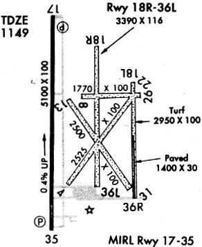
Runways
Runway Summary
| Runways: | 01/19 02/20 18/36 |
| Longest Runway: | 18/36 is 5101 ft (1555 m) long |
| Runways with an Instrument Approach: |
CHK Airport Runway Details
| Runway 01/19 | 2232 ft x 100 ft (680 m x 30 m) | |
| Runway Length Source: | FAA OE/AAA as of 06/11/2003 | |
| Surface: | Turf - Fair condition - No special surface treatment | |
Runway 01 |
Runway 19 |
|
Elevation: |
1137.2 | 1144.4 |
Latitude: |
35-05-44.8500N | 35-06-06.9300N |
Longitude: |
097-58-00.7600W | 097-58-00.7600W |
|
Runway True Alignment: |
000 | 180 |
Glide Path Angle: |
0.0 degrees | 0.0 degrees |
Runway Markings Type: |
Nonstandard (other than numbers only) | Nonstandard (other than numbers only) |
Runway Markings Condition: |
Fair | Fair |
| Runway 02/20 | 2404 ft x 100 ft (733 m x 30 m) | |
| Runway Length Source: | FAA OE/AAA as of 03/03/2021 | |
| Surface: | Turf - Fair condition - No special surface treatment | |
Runway 02 |
Runway 20 |
|
Elevation: |
1136.0 | 1142.7 |
Latitude: |
35-05-39.5500N | 35-05-59.4900N |
Longitude: |
097-58-02.5300W | 097-57-46.7800W |
|
Runway True Alignment: |
033 | 213 |
Glide Path Angle: |
0.0 degrees | 0.0 degrees |
Runway Markings Type: |
Nonstandard (other than numbers only) | Nonstandard (other than numbers only) |
Runway Markings Condition: |
Fair | Fair |
Object at End: |
TREE | |
Object Height: |
49 | |
Distance from End: |
914 |
| Runway 18/36 | 5101 ft x 100 ft (1555 m x 30 m) | |
| Runway Length Source: | NGS as of 05/29/2008 | |
| Surface: | Turf - Fair condition - No special surface treatment | |
| Runway Edge Lights: | Medium Intensity | |
Runway Weight Bearing Capacity (in thousands of pounds) |
||
| Single Wheel Landing Gear: | 40.0 | |
| Dual Wheel Landing Gear: | 52.0 | |
Runway 18 |
Runway 36 |
|
Elevation: |
1150.3 | 1129.8 |
Latitude: |
35-06-12.3096N | 35-05-21.8636N |
Longitude: |
097-58-09.1582W | 097-58-09.1489W |
|
Runway True Alignment: |
180 | 000 |
Glide Path Angle: |
3.0 degrees | 3.0 degrees |
Traffic Pattern: |
Left | Left |
Runway Markings Type: |
Nonprecision Instrument | Nonprecision Instrument |
Runway Markings Condition: |
Fair | Fair |
Object at End: |
TREES | |
Object Height: |
43 | |
Distance from End: |
944 | |
Visual Glide Slope Indicators: |
4-Light PAPI On Left Side Of Runway | 4-Light PAPI On Left Side Of Runway |
Threshold Crossing Height: |
40 | 40 |
Services
Airframe Repair: |
Major |
Powerplant Repair: |
Major |
Fuel Available: |
100LL, Jet A |
Landing Fees: |
No |
Parking: |
Hangars and tiedowns available |
Maps & Diagrams
CHK Sectional
Flight Planning
at skyvector.com
at skyvector.com