Location
Latitude: |
42-09-28.6000N (42.157944) |
Longitude: |
072-42-57.1000W (-72.715861) |
Elevation: |
270.0 feet MSL (82 m MSL) |
Magnetic Variation: |
13.4 W (as of April 2024 from WMM2020 model) |
Time Zone: |
UTC -5.0 (Standard Time) UTC -4.0 (Daylight Savings Time) |
From City: |
03 N.M. N of Westfield/Springfield, Massachusetts |
Found On: |
New York Chart |
FAA Region: |
ANE |
Contacts
Manager: |
Publicly owned: |
| CHRISTOPHER J. WILLENBORG 110 AIRPORT RD WESTFIELD, MA 01085 413-572-6275 |
CITY OF WESTFIELD CITY HALL, 59 COURT ST WESTFIELD, MA 01085 413-572-6201 |
Operations
Airport Status: |
Operational |
Facility Use: |
Public |
Type: |
Airport |
Activation Date: |
04/1940 |
Control tower: |
Yes |
Attendance (Months/Days/Hours): |
Months/Days/Hours ALL/ALL/0700-1900 LOCAL |
Boundary ARTCC: |
ZBW (Boston) |
Responsible ARTCC: |
ZBW (Boston) |
Lighting Schedule: |
SEE RMK |
Segmented Circle Indicator: |
Yes |
Traffic Pattern Altitude (MSL): |
1270 feet (387 m) |
NOTAMs Facility: |
BAF |
NOTAM-D Service: |
Yes |
International Airport of Entry: |
No |
Customs Landing Rights: |
Yes |
Military Landing Rights: |
Yes |
Civil/Military Joint Use: |
No |
Aircraft Rescue and Firefighting: |
Class IV ARFF Index: A Air Carrier Service: Not Scheduled Certification Date: 12/1974 |
Based Aircraft
| Single Engine: | 92 |
| Multi Engine: | 5 |
| Jet Engine: | 4 |
| GA Helicopters: | 2 |
| Military Aircraft: | 26 |
| Ultralights: | 1 |
Annual Operations (as of 08/31/2023)
| Total Operations: | 50739 | |
| Commercial: | 16 | 0.0% |
| Air Taxi: | 1200 | 2.4% |
| GA Local: | 25786 | 50.8% |
| GA Itinerant: | 19087 | 37.6% |
| Military Aircraft: | 4650 | 9.2% |
Communications
| CTAF: | 118.900 |
| Tower: | WESTFIELD 118.9 251.1 Hrs: 0700-2200 |
| Clearance Del.: | 121.7 |
| Ground: | 121.7 289.4 |
| Approach: | BRADLEY |
| Departure: | BRADLEY |
| ATIS: | 127.1 263.15 Hrs: 24 |
| ASOS: | 127.1 (413-568-2267) |
| EMERG: | 121.5 |
| ANG OPS: | 309.0 |
| NG OPS: | 356.3 |
| NG OPS: | 46.75 |
| NG OPS: | 123.05 |
| EMERG: | 243.0 |
- HAWK OPS.
Fixed Based Operators (FBOs) & Fuel
(Click on a business for detail)
Please help us keep this information up to date. This is a FREE SERVICE just like everything else on Airport Guide! If you see that a business needs to be added, modified, or deleted please fill out our Update Form.
To add, modify, or delete a business click here.
Please help us keep this information up to date. This is a FREE SERVICE just like everything else on Airport Guide! If you see that a business needs to be added, modified, or deleted please fill out our Update Form.
Area Code: 413 |
| Business Name | Frequency | Phone | Fuel Grade |
|---|---|---|---|
| AirFlyte, Inc.
Update FBO info |
Unicom 122.95 | 568-4686 | |
| Charis Air Corporation
Update FBO info |
Unicom 123.3 | 562-4161, 800-598-6044 | 80, 100LL, Jet A |
| K-C Aviation, Inc.
Update FBO info |
562-5860, after hours call 562-5866 | Jet A | |
| Northeastern Air Services
Update FBO info |
Unicom 123.5 | 568-8976 | 100LL, Jet A |
| Northeastern Avionics, Inc.
Update FBO info |
Unicom 123.5 | 562-5124 | 100LL, Jet A |
Flight Service Stations
| Primary | Alternate | |
| FSS on Field: | N | |
| FSS Name (ID): | Burlington(BTV) | |
| Frequency: | ||
| Toll Free Phone: | 1-800-WX-BRIEF |
Instrument Procedures / Charts
FAA Terminal Procedures valid from 0901Z 03/21/24 to 0901Z 04/18/24.
There are various types of charts available for an airport. They are listed in the Page Type column. Here is a legend for those types:
APD - Airport Diagram
DP - Departure Procedure Charts
HOT - Hot Spots
IAP - Instrument Approach Procedure Charts
MIN - Minimums
STAR - Standard Terminal Arrival Charts
| Page Type | Page Name | Volume | Action Since Last Cycle |
|---|---|---|---|
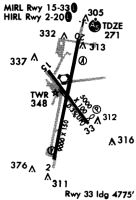
| APD | AIRPORT DIAGRAM | NE-1 | |
| DP | COASTAL NINE | NE-1 | |
| DP | COASTAL NINE[DELIMITER] CONT.1 | NE-1 | |
| HOT | HOT SPOT | NE-1 | |
| IAP | HI-ILS OR LOC RWY 20 | NE-1 | |
| IAP | HI-TACAN RWY 20 | NE-1 | |
| IAP | ILS OR LOC RWY 20 | NE-1 | |
| IAP | RNAV (GPS) RWY 02 | NE-1 | |
| IAP | RNAV (GPS) RWY 20 | NE-1 | |
| IAP | VOR OR TACAN RWY 02 | NE-1 | |
| IAP | VOR RWY 20 | NE-1 | |
| MIN | ALTERNATE MINIMUMS | NE-1 | |
| MIN | TAKEOFF MINIMUMS | NE-1 | |
| STAR | DEER PARK THREE | NE-1 | |
| STAR | STELA ONE | NE-1 | |
| STAR | STELA ONE[DELIMITER] CONT.1 | NE-1 |
Terminal Procedures are only available for airports in several countries with more being added all the time. If you are looking for a specific country's charts, please send an email to support(at)airportguide.com stating the country name. This will be used to prioritize the implementation.
Navigation Aids (Navaids) near BAF
| Dist (NM) | ID | Morse Code | Name | Type | Freq | True Hdg | Mag Hdg |
|---|---|---|---|---|---|---|---|
| 0.2 | BAF | _ . . . . _ . . _ . | Barnes | VORTAC | 113.00 | 356 | 369 |
| 8.8 | CEF | _ . _ . . . . _ . | Westover | TACAN | 114.00 | 74 | 87 |
| 13.1 | BDL | _ . . . _ . . . _ . . | Bradley | VORTAC | 109.00 | 174 | 187 |
| 13.1 | CTR | _ . _ . _ . _ . | Chester | VOR-DME | 115.10 | 307 | 320 |
| 13.6 | BDL | _ . . . _ . . . _ . . | Bradley | VOT | 111.40 | 174 | 187 |
| 25.5 | HFD | . . . . . . _ . _ . . | Hartford | VOT | 108.20 | 173 | 186 |
| 30.6 | GBR | _ _ . _ . . . . _ . | Great Barrington | NDB | 395 | 273 | 286 |
| 31.1 | ORE | _ _ _ . _ . . | Orange | NDB | 205 | 37 | 51 |
| 31.9 | HFD | . . . . . . _ . _ . . | Hartford | VOR-DME | 114.90 | 166 | 179 |
| 37.3 | GDM | _ _ . _ . . _ _ | Gardner | VOR-DME | 110.60 | 51 | 65 |
| 38.2 | ORH | _ _ _ . _ . . . . . | Worcester | VOT | 108.20 | 79 | 93 |
| 40.7 | PUT | . _ _ . . . _ _ | Putnam | VOR-DME | 117.40 | 107 | 121 |
| 42.5 | EEN | . . _ . | Keene | DME | 109.4 | 26 | 40 |
| 45.1 | PFH | . _ _ . . . _ . . . . . | Philmont | NDB | 272 | 277 | 290 |
| 45.8 | PWL | . _ _ . . _ _ . _ . . | Pawling | VOR-DME | 114.30 | 239 | 252 |
| 46.6 | VWD | . . . _ . _ _ _ . . | Mount Snow | NDB | 224 | 351 | 364 |
| 48.2 | ORW | _ _ _ . _ . . _ _ | Norwich | VOR-DME | 110.00 | 138 | 152 |
| 48.6 | FIT | . . _ . . . _ | Fitchburg | NDB | 365 | 60 | 74 |
| 49.8 | JWE | . _ _ _ . _ _ . | Clera | NDB | 362 | 201 | 214 |
| 50.7 | MAD | _ _ . _ _ . . | Madison | VOR-DME | 110.40 | 178 | 191 |
Nearby Airports with Fuel
Notices to Airmen (NOTAMS)
Remarks
| A110-1 | JET ACFT STARTING UNITS AVBL. |
| A110-10 | CSTMS/AG/IMG - 1300-2300Z++ MON-FRI, FONE PRIOR 2300Z++ PRECEDING WKD C413-785-0365, C800-973-2867. |
| A110-11 | MISC - FIRST 400 FT RWY 02/20 CONC, MID 8200 FT ASPH. RWY 02/20 GROOVED. CLASS D ASP EFF 1200-0300Z++, OT CLASS G. LDG FEE COML, CORPORATE AND ALL ACFT OVER 5000 LB. FLT NOTIFICATION SVC, ADCUS, AVBL. LAWRS. |
| A110-12 | BE AWARE WING TIP CLRNC S RUNUP/D-ARM PAD TWY CNTRLN MKGS FOR F-15 A/C ONLY. |
| A110-13 | SERVICE-A-GEAR: REQ THRU TWR DUR TWR OPR HR, WHEN TWR CLSD REQ THRU ANG CP, WHIP ON UHF 309.0. RWY 02/20, MIL ACFT ARST BARRIERS MAY FAIL IN THE UP POSN. VERIFY STATUS OF BARRIERS PRIOR TO LDG. HVY ACFT SHOULD AVOID LDG DRCTLY ON ARST BARRIER. RWY GROOVING FOR SFC DRAINAGE WI 10 FT N & S OF BOTH ARST SYSS. |
| A110-14 | MILITARY: ANG: NO ACFT WITH WINGSPAN GREATER THAN 110 FT ALLOWED ON ANG RAMP. |
| A110-15 | RWY 2/20 MIL ACFT ARST BARRIERS MAY FAIL IN THE UP PSN. SML GA ACFT SHOULD USE CTN, SPCLY AT NGT, AND IF POSS CFM THE ACTUAL STS OF THE BARRIERS PRIOR TO LDG. |
| A110-16 | COLD TEMPERATURE AIRPORT. ALTITUDE CORRECTION REQUIRED AT OR BELOW -21C. |
| A110-17 | MILITARY: ANG: BASH II COND JUL & AUG FOR MIGRATORY BIRD ACT. |
| A110-18 | FOR CD WHEN ATCT CLSD, CTC BRADLEY APCH AT 860-386-3597. |
| A110-2 | SVR DOWNDRAFT AER 33 WHEN WIND NW IN EXCESS OF 15 KT. BIRDS & OTHER WILDLIFE ON & INVOF ARPT. |
| A110-4 | TWY G CLSD TO CIV OPS. |
| A110-7 | ACFT & HEL NOISE ABATEMENT PROCS IN EFCT - AMGR. |
| A110-8 | MILITARY: ANG: OPR 1200-2200Z++ TUE-FRI EXC HOL. LTD COPTER MAINT, FUEL AND ACFT PRK ARNG RAMP. NO COPTER LDG OR DEP FR PRK RAMP. CTC DSN 698-1811 OR C413-568-9151 EXTN 1811. |
| A110-9 | MILITARY: ANG: ALL TRAN ACFT MUST OBTAIN PPR NR 48 HR PRIOR; CTC C413-568-9151 EXTN 698-1228/9 OR DSN 698-1228/9. OFFL BUS 1230-2200Z++ TUE-FRI, CLSD HOL. NO DE-ICING AVBL. FOR CURRENT BIRD WATCH COND CTC HAWK OPS 309.0; DURG NON-DUTY HR CTC WHIP ON 309.0. BASH PHASE II COND, JUL, AUG AND SEP FOR MIGRATORY BIRD ACT. |
| A17 | FUEL AVBL 0700-1900; SVC AFT 1900 PPR - 413-485-0078. |
| A24 | FEE FOR COML; CORPORATE; ACFT OVR 7500 LBS. |
| A26 | PPR 24 HR FOR ACR OPS WITH MORE THAN 9 PAX - AMGR. |
| A30-15/33 | NOT AVBL FOR SKEDD ACR OPS MORE THAN 9 PAX SEATS OR UNSKED ACR OPS AT LEAST 31 PAX SEATS. |
| A31-02/20 | 200 FT OVRN NE END & SW END. |
| A43-15 | UNUSBL BYD 4 NM. |
| A81-APT | DUSK-DAWN; WHEN ATCT CLSD ACTVT MALSR RWY 20; PAPI RWY 15; HIRL RWY 02/20; MIRL RWY 15/33 - CTAF. PAPI RWY 33 OPR CONSLY. |
| E147 | TPA 1300 (1029) LGT ACFT; 1800 (1529) HVY & MIL ACFT. EXPC MIL OVHD & CLSD PAT TFC. |
| E60-02 | BAK-14 BAK-12B(B) (1420 FT). |
| E60-20 | BAK-14 BAK-12B(B) (1450 FT). |
Runways
Runway Summary
| Runways: | 02/20 15/33 |
| Longest Runway: | 02/20 is 9000 ft (2743 m) long |
| Runways with an Instrument Approach: | 20 |
BAF Airport Runway Details
| Runway 02/20 | 9000 ft x 150 ft (2743 m x 46 m) | |
| Runway Length Source: | 3RD PARTY SURVEY as of 10/15/2011 | |
| Surface: | Asphalt - Excellent condition - Saw-cut or plastic grooved | |
| Runway Pavement Class: | 58 /R/B/W/T | |
| Runway Edge Lights: | High Intensity | |
Runway Weight Bearing Capacity (in thousands of pounds) |
||
| Single Wheel Landing Gear: | 75.0 | |
| Dual Wheel Landing Gear: | 160.0 | |
| Dual Tandem Wheel Landing Gear: | 240.0 | |
Runway 02 |
Runway 20 |
|
Elevation: |
260.4 | 266.5 |
Latitude: |
42-08-43.0807N | 42-10-10.5755N |
Longitude: |
072-43-07.7517W | 072-42-46.5557W |
|
Runway True Alignment: |
010 | 190 |
ILS Type: |
ILS | |
Glide Path Angle: |
3.0 degrees | 3.0 degrees |
Traffic Pattern: |
Left | Left |
Runway Markings Type: |
Precision Instrument | Precision Instrument |
Runway Markings Condition: |
Good | Good |
Arresting Device: |
BAK-14 | BAK-14 |
Object at End: |
TREES | TREES |
Object Height: |
56 | 83 |
Distance from End: |
1325 | 2950 |
Object Centerline Offset: |
300 ft. right of centerline | 175 ft. right of centerline |
Visual Glide Slope Indicators: |
4-Light PAPI On Left Side Of Runway | 4-Light PAPI On Left Side Of Runway |
Runway Visual Range (RVR): |
Touchdown | |
Approach Light System: |
1,400 Foot Medium Intensity Approach Lighting System With Runway Alignment Indicator Lights | |
REIL: |
No | No |
Touchdown Lights: |
No | No |
Centerline Lights: |
No | No |
Threshold Crossing Height: |
50 | 50 |
Declared Distances |
||
Take Off Run Avbl. (TORA): |
9000 | 9000 |
Take Off Distance Avbl. (TODA): |
9000 | 9000 |
Actual Stop Dist. Avbl. (ASDA): |
9000 | 8919 |
Landing Dist. Avbl. (LDA): |
9000 | 8919 |
| Runway 15/33 | 5000 ft x 75 ft (1524 m x 23 m) | |
| Runway Length Source: | 3RD PARTY SURVEY as of 10/15/2011 | |
| Surface: | Asphalt - Excellent condition - Saw-cut or plastic grooved | |
| Runway Pavement Class: | 26 /F/A/X/U | |
| Runway Edge Lights: | Medium Intensity | |
Runway Weight Bearing Capacity (in thousands of pounds) |
||
| Single Wheel Landing Gear: | 51.0 | |
| Dual Wheel Landing Gear: | 60.0 | |
| Dual Tandem Wheel Landing Gear: | 155.0 | |
Runway 15 |
Runway 33 |
|
Elevation: |
261.5 | 246.9 |
Latitude: |
42-09-50.7851N | 42-09-12.8399N |
Longitude: |
072-43-18.3599W | 072-42-35.8716W |
|
Runway True Alignment: |
140 | 320 |
Glide Path Angle: |
3.5 degrees | 4.0 degrees |
Traffic Pattern: |
Left | Left |
Runway Markings Type: |
Basic | Basic |
Runway Markings Condition: |
Good | Good |
Object at End: |
TREES | TREES |
Object Height: |
48 | 30 |
Distance from End: |
1150 | 150 |
Object Centerline Offset: |
300 ft. right of centerline | 175 ft. right of centerline |
Visual Glide Slope Indicators: |
4-Light PAPI On Left Side Of Runway | 4-Light PAPI On Left Side Of Runway |
REIL: |
Yes | No |
Touchdown Lights: |
No | No |
Centerline Lights: |
No | No |
Threshold Crossing Height: |
41 | 42 |
Threshold Elevation: |
262.3 | |
Displaced Threshold: |
490 | |
Threshold Latitude: |
42-09-47.0645N | |
Threshold Longitude: |
072-43-14.1906W | |
Declared Distances |
||
Take Off Run Avbl. (TORA): |
5000 | 5000 |
Take Off Distance Avbl. (TODA): |
5000 | 5000 |
Actual Stop Dist. Avbl. (ASDA): |
4508 | 5000 |
Landing Dist. Avbl. (LDA): |
4510 | 5000 |
Services
Airframe Repair: |
Major |
Powerplant Repair: |
Major |
Fuel Available: |
100LL |
Landing Fees: |
Yes |
Parking: |
Tiedowns available |
Maps & Diagrams
BAF Sectional
Flight Planning
at skyvector.com
at skyvector.com