Location
Latitude: |
43-12-42.7000N (43.211861) |
Longitude: |
090-10-47.4000W (-90.179833) |
Elevation: |
717.3 feet MSL (219 m MSL) |
Magnetic Variation: |
2.3 W (as of April 2024 from WMM2020 model) |
Time Zone: |
UTC -6.0 (Standard Time) UTC -5.0 (Daylight Savings Time) |
From City: |
02 N.M. N of Lone Rock, Wisconsin |
Found On: |
Chicago Chart |
FAA Region: |
AGL |
Contacts
Manager: |
Publicly owned: |
| MARK HIGGS E2525 CO. HWY JJ SPRING GREEN, WI 53588 608-583-2600 |
SAUK,IOWA,&RICHLAND CO IOWA CO COURT HOUSE DODGEVILLE, WI 53533 608-583-2600 |
Operations
Airport Status: |
Operational |
Facility Use: |
Public |
Type: |
Airport |
Activation Date: |
11/1943 |
Control tower: |
No |
Attendance (Months/Days/Hours): |
Months/Days/Hours ALL/MON-FRI/0800-1700 |
Boundary ARTCC: |
ZAU (Chicago) |
Responsible ARTCC: |
ZAU (Chicago) |
Lighting Schedule: |
SEE RMK |
Segmented Circle Indicator: |
Yes |
Traffic Pattern Altitude (MSL): |
1717 feet (523 m) |
NOTAMs Facility: |
LNR |
NOTAM-D Service: |
Yes |
International Airport of Entry: |
No |
Customs Landing Rights: |
No |
Based Aircraft
| Single Engine: | 26 |
| Jet Engine: | 1 |
Annual Operations (as of 09/26/2022)
| Total Operations: | 16000 | |
| Air Taxi: | 500 | 3.1% |
| GA Local: | 7300 | 45.6% |
| GA Itinerant: | 8000 | 50.0% |
| Military Aircraft: | 200 | 1.2% |
Communications
| CTAF: | 123.000 |
| Unicom: | 123.000 |
| Approach: | MADISON 135.45 135.45 CHICAGO ARTCC |
| Departure: | MADISON 135.45 135.45 CHICAGO ARTCC |
| ASOS: | 119.425 (608-583-2576) |
- APCH/DEP SVC PRVDD BY CHICAGO ARTCC ON FREQS 133.3/257.925 (LONE ROCK RCAG) WHEN MADISON APCH CTL CLSD.
Fixed Based Operators (FBOs) & Fuel
(Click on a business for detail)
Please help us keep this information up to date. This is a FREE SERVICE just like everything else on Airport Guide! If you see that a business needs to be added, modified, or deleted please fill out our Update Form.
To add, modify, or delete a business click here.
Please help us keep this information up to date. This is a FREE SERVICE just like everything else on Airport Guide! If you see that a business needs to be added, modified, or deleted please fill out our Update Form.
Area Code: 608 |
| Business Name | Frequency | Phone | Fuel Grade |
|---|---|---|---|
| Higgs Aviation
Update FBO info |
Unicom 123.0 | 583-2600 | 100LL, Jet A |
Flight Service Stations
| Primary | Alternate | |
| FSS on Field: | N | |
| FSS Name (ID): | Green Bay(GRB) | |
| Frequency: | ||
| Toll Free Phone: | 1-800-WX-BRIEF |
Instrument Procedures / Charts
FAA Terminal Procedures valid from 0901Z 03/21/24 to 0901Z 04/18/24.
There are various types of charts available for an airport. They are listed in the Page Type column. Here is a legend for those types:
APD - Airport Diagram
DP - Departure Procedure Charts
HOT - Hot Spots
IAP - Instrument Approach Procedure Charts
MIN - Minimums
STAR - Standard Terminal Arrival Charts
| Page Type | Page Name | Volume | Action Since Last Cycle |
|---|---|---|---|
| IAP | LOC RWY 27 | EC-3 | |
| IAP | RNAV (GPS) RWY 09 | EC-3 | |
| IAP | RNAV (GPS) RWY 27 | EC-3 | |
| MIN | ALTERNATE MINIMUMS | EC-3 | |
| MIN | TAKEOFF MINIMUMS | EC-3 |
Terminal Procedures are only available for airports in several countries with more being added all the time. If you are looking for a specific country's charts, please send an email to support(at)airportguide.com stating the country name. This will be used to prioritize the implementation.
Navigation Aids (Navaids) near LNR
| Dist (NM) | ID | Morse Code | Name | Type | Freq | True Hdg | Mag Hdg |
|---|---|---|---|---|---|---|---|
| 5.4 | LNR | . _ . . _ . . _ . | Lone Rock | DME | 116.05 | 22 | 24 |
| 19.5 | MRJ | _ _ . _ . . _ _ _ | Mineral Point | NDB | 365 | 186 | 188 |
| 27.3 | DLL | _ . . . _ . . . _ . . | Dells | VORTAC | 117.00 | 41 | 44 |
| 27.4 | HBW | . . . . _ . . . . _ _ | Kickapoo | NDB | 251 | 345 | 347 |
| 37.0 | MSN | _ _ . . . _ . | Madison | VORTAC | 108.60 | 95 | 98 |
| 37.6 | MS | _ _ . . . | Monah | NDB | 400 | 103 | 106 |
| 44.0 | VOK | . . . _ _ _ _ _ . _ | Volk | TACAN | 110.40 | 355 | 357 |
| 48.0 | CMY | _ . _ . _ _ _ . _ _ | Mccoy | NDB | 412 | 335 | 337 |
| 53.9 | DBQ | _ . . _ . . . _ _ . _ | Dubuque | VORTAC | 115.80 | 205 | 207 |
| 56.4 | DB | _ . . _ . . . | Zilom | NDB | 341 | 199 | 201 |
| 59.5 | UKN | . . _ _ . _ _ . | Waukon | DME | 116.6 | 274 | 276 |
| 61.4 | JVL | . _ _ _ . . . _ . _ . . | Janesville | VOR-DME | 114.30 | 129 | 132 |
| 61.5 | LSE | . _ . . . . . . | La Crosse | DME | 108.4 | 310 | 312 |
| 61.5 | JVL | . _ _ _ . . . _ . _ . . | Janesville | NDB | 375 | 125 | 128 |
| 63.7 | RYV | . _ . _ . _ _ . . . _ | Rock River | NDB | 371 | 91 | 94 |
| 64.1 | EK | . _ . _ | Nepco | NDB | 326 | 11 | 14 |
| 65.8 | UNU | . . _ _ . . . _ | Juneau | NDB | 344 | 78 | 81 |
| 66.8 | LS | . _ . . . . . | Mindi | NDB | 272 | 315 | 317 |
| 69.0 | BCK | _ . . . _ . _ . _ . _ | Black River Falls | NDB | 362 | 335 | 337 |
| 70.0 | ODI | _ _ _ _ . . . . | Nodine | VORTAC | 117.90 | 307 | 309 |
Nearby Airports with Fuel
Notices to Airmen (NOTAMS)
Remarks
| A110-1 | FOR CD CTC MADISON APP/DEP CON AT 608-249-8240. WHEN MADISON APCH CLSD, FOR CD CTC CHICAGO ARTCC AT 630-906-8921. |
| A110-2 | COLD TEMPERATURE AIRPORT. ALTITUDE CORRECTION REQUIRED AT OR BELOW -30C. |
| A15 | EMAIL ADDRESS: MARKHIGGSTCA@YAHOO.COM (ALL LOWER CASE) |
| A70-FUEL-10 | 0LL SELF-SERVE FUEL AVBL 24 HRS. |
| A81-APT | MIRL RWY 09/27 PRESET TO LOW SS-SR; TO INCR INTST & ACTVT REIL 09 & 27; MIRL RWY 09/27; MIRL RWY 18/36 - CTAF. PAPI RWY 09 & 27 OPR CONSLY. |
Runways
Runway Summary
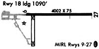
| Runways: | 09/27 18/36 |
| Longest Runway: | 09/27 is 5000 ft (1524 m) long |
| Runways with an Instrument Approach: | 27 |
LNR Airport Runway Details
| Runway 09/27 | 5000 ft x 75 ft (1524 m x 23 m) | |
| Runway Length Source: | 3RD PARTY SURVEY as of 06/24/2006 | |
| Surface: | Asphalt - Excellent condition - No special surface treatment | |
| Runway Edge Lights: | Medium Intensity | |
Runway Weight Bearing Capacity (in thousands of pounds) |
||
| Single Wheel Landing Gear: | 12.5 | |
Runway 09 |
Runway 27 |
|
Elevation: |
714.5 | 716.7 |
Latitude: |
43-12-45.3039N | 43-12-45.6444N |
Longitude: |
090-11-13.8072W | 090-10-06.2871W |
|
Runway True Alignment: |
089 | 269 |
ILS Type: |
LOC/DME | |
Glide Path Angle: |
3.0 degrees | 4.0 degrees |
Traffic Pattern: |
Left | Left |
Runway Markings Type: |
Nonprecision Instrument | Nonprecision Instrument |
Runway Markings Condition: |
Good | Good |
Object at End: |
ANT | TREES |
Object Height: |
34 | 325 |
Distance from End: |
1070 | 6700 |
Object Centerline Offset: |
265 ft. left of centerline | 1100 ft. right of centerline |
Visual Glide Slope Indicators: |
2-Light PAPI On Left Side Of Runway | 2-Light PAPI On Left Side Of Runway |
REIL: |
Yes | Yes |
Touchdown Lights: |
No | No |
Centerline Lights: |
No | No |
Threshold Crossing Height: |
35 | 35 |
| Runway 18/36 | 1850 ft x 60 ft (564 m x 18 m) | |
| Runway Length Source: | 3RD PARTY SURVEY as of 06/24/2006 | |
| Surface: | Asphalt - Excellent condition - No special surface treatment | |
| Runway Edge Lights: | Medium Intensity | |
Runway Weight Bearing Capacity (in thousands of pounds) |
||
| Single Wheel Landing Gear: | 12.5 | |
Runway 18 |
Runway 36 |
|
Elevation: |
714.6 | 715.9 |
Latitude: |
43-12-44.3492N | 43-12-26.0767N |
Longitude: |
090-11-07.2526W | 090-11-07.4457W |
|
Runway True Alignment: |
180 | 360 |
Glide Path Angle: |
0.0 degrees | 0.0 degrees |
Runway Markings Type: |
Basic | Basic |
Runway Markings Condition: |
Good | Good |
Object at End: |
ROAD | ROAD |
Object Height: |
15 | 15 |
Distance from End: |
440 | 380 |
Object Centerline Offset: |
265 ft. left of centerline | 1100 ft. right of centerline |
Services
Airframe Repair: |
None |
Powerplant Repair: |
None |
Bottled Oxygen: |
None |
Bulk Oxygen: |
None |
Fuel Available: |
80, 100LL |
Landing Fees: |
No |
Parking: |
Tiedowns available |
Maps & Diagrams
LNR Sectional
Flight Planning
at skyvector.com
at skyvector.com