Location
Latitude: |
42-36-53.6425N (42.614901) |
Longitude: |
089-35-25.4522W (-89.590403) |
Elevation: |
1085.5 feet MSL (331 m MSL) |
Magnetic Variation: |
2.7 W (as of April 2024 from WMM2020 model) |
Time Zone: |
UTC -6.0 (Standard Time) UTC -5.0 (Daylight Savings Time) |
From City: |
03 N.M. NE of Monroe, Wisconsin |
Found On: |
Chicago Chart |
FAA Region: |
AGL |
Contacts
Manager: |
Publicly owned: |
| ROB DRIVER W4711 HWY 59 MONROE, WI 53566 (608) 329-7777 |
CITY OF MONROE 1110 18TH AVENUE MONROE, WI 53566 608-329-4101 |
Operations
Airport Status: |
Operational |
Facility Use: |
Public |
Type: |
Airport |
Activation Date: |
11/1963 |
Control tower: |
No |
Attendance (Months/Days/Hours): |
Months/Days/Hours APR-OCT/ALL/0700-1700 |
Boundary ARTCC: |
ZAU (Chicago) |
Responsible ARTCC: |
ZAU (Chicago) |
Lighting Schedule: |
SEE RMK |
Segmented Circle Indicator: |
No |
Traffic Pattern Altitude (MSL): |
2086 feet (636 m) |
NOTAMs Facility: |
EFT |
NOTAM-D Service: |
Yes |
International Airport of Entry: |
No |
Customs Landing Rights: |
No |
Military Landing Rights: |
Yes |
Civil/Military Joint Use: |
No |
Based Aircraft
| Single Engine: | 40 |
| Jet Engine: | 1 |
Annual Operations (as of 04/16/2021)
| Total Operations: | 17300 | |
| Air Taxi: | 500 | 2.9% |
| GA Local: | 8400 | 48.6% |
| GA Itinerant: | 8100 | 46.8% |
| Military Aircraft: | 300 | 1.7% |
Communications
| CTAF: | 123.050 |
| Unicom: | 123.050 |
| Approach: | ROCKFORD 126.0 126.0 |
| Departure: | ROCKFORD 126.0 126.0 |
| AWOS-3: | 118.375 (608-328-8359) |
Fixed Based Operators (FBOs) & Fuel
(Click on a business for detail)
Please help us keep this information up to date. This is a FREE SERVICE just like everything else on Airport Guide! If you see that a business needs to be added, modified, or deleted please fill out our Update Form.
To add, modify, or delete a business click here.
Please help us keep this information up to date. This is a FREE SERVICE just like everything else on Airport Guide! If you see that a business needs to be added, modified, or deleted please fill out our Update Form.
Area Code: 608 |
| Business Name | Frequency | Phone | Fuel Grade |
|---|---|---|---|
| Touch & Go Aviation, Inc.
Update FBO info |
Unicom 123.0 | 329-7777 | 80, 100LL, Jet A |
Flight Service Stations
| Primary | Alternate | |
| FSS on Field: | N | |
| FSS Name (ID): | Green Bay(GRB) | |
| Frequency: | ||
| Toll Free Phone: | 1-800-WX-BRIEF |
Instrument Procedures / Charts
FAA Terminal Procedures valid from 0901Z 03/21/24 to 0901Z 04/18/24.
There are various types of charts available for an airport. They are listed in the Page Type column. Here is a legend for those types:
APD - Airport Diagram
DP - Departure Procedure Charts
HOT - Hot Spots
IAP - Instrument Approach Procedure Charts
MIN - Minimums
STAR - Standard Terminal Arrival Charts
| Page Type | Page Name | Volume | Action Since Last Cycle |
|---|---|---|---|
| IAP | RNAV (GPS) RWY 12 | EC-3 | |
| IAP | RNAV (GPS) RWY 30 | EC-3 | |
| IAP | VOR/DME RWY 30 | EC-3 | |
| MIN | ALTERNATE MINIMUMS | EC-3 | |
| MIN | TAKEOFF MINIMUMS | EC-3 |
Terminal Procedures are only available for airports in several countries with more being added all the time. If you are looking for a specific country's charts, please send an email to support(at)airportguide.com stating the country name. This will be used to prioritize the implementation.
Navigation Aids (Navaids) near KEFT
| Dist (NM) | ID | Morse Code | Name | Type | Freq | True Hdg | Mag Hdg |
|---|---|---|---|---|---|---|---|
| 21.7 | JVL | . _ _ _ . . . _ . _ . . | Janesville | VOR-DME | 114.30 | 98 | 101 |
| 24.2 | JVL | . _ _ _ . . . _ . _ . . | Janesville | NDB | 375 | 89 | 92 |
| 28.9 | MS | _ _ . . . | Monah | NDB | 400 | 21 | 24 |
| 29.1 | RFD | . _ . . . _ . _ . . | Rockford | DME | 110.8 | 143 | 146 |
| 32.5 | MRJ | _ _ . _ . . _ _ _ | Mineral Point | NDB | 365 | 300 | 303 |
| 33.7 | MSN | _ _ . . . _ . | Madison | VORTAC | 108.60 | 19 | 22 |
| 37.1 | RF | . _ . . . _ . | Gilmy | NDB | 275 | 143 | 146 |
| 39.1 | PLL | . _ _ . . _ . . . _ . . | Polo | VOR-DME | 111.20 | 175 | 178 |
| 44.3 | LVV | . _ . . . . . _ . . . _ | Lake Lawn | NDB | 404 | 83 | 86 |
| 47.2 | LNR | . _ . . _ . . _ . | Lone Rock | DME | 116.05 | 329 | 332 |
| 47.9 | DB | _ . . _ . . . | Zilom | NDB | 341 | 248 | 250 |
| 50.7 | RYV | . _ . _ . _ _ . . . _ | Rock River | NDB | 371 | 48 | 51 |
| 51.1 | DBQ | _ . . _ . . . _ _ . _ | Dubuque | VORTAC | 115.80 | 255 | 257 |
| 54.9 | BOZ | _ . . . _ _ _ _ _ . . | Whiteside | NDB | 254 | 189 | 192 |
| 56.7 | DLL | _ . . . _ . . . _ . . | Dells | VORTAC | 117.00 | 352 | 355 |
| 57.0 | BUU | _ . . . . . _ . . _ | Burbun | DME | 114.5 | 85 | 88 |
| 62.5 | UNU | . . _ _ . . . _ | Juneau | NDB | 344 | 38 | 41 |
| 62.8 | FN | . . _ . _ . | Hillz | NDB | 517 | 214 | 216 |
| 64.9 | BAE | _ . . . . _ . | Badger | VOR-DME | 116.40 | 61 | 64 |
| 67.3 | CVA | _ . _ . . . . _ . _ | Davenport | VORTAC | 113.80 | 216 | 218 |
Nearby Airports with Fuel
Notices to Airmen (NOTAMS)
Remarks
| A110-3 | FOR CD CTC CHICAGO ARTCC AT 630-906-8921. |
| A17 | FOR ATTENDANT AFT HRS CALL 608-329-7777. |
| A43-30 | PAPI UNUSBL BYD 6 DEGS RIGHT OF CNTRLN. |
| A70-FUEL-10 | 0LL 24 HR FUEL AVBL WITH CREDIT CARD. |
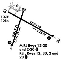
| A81-APT | MIRL RY 12/30 OPERS LOW INTST; TO INCR INTST & ACTVT REIL RY 02/20; PAPI RY 02; MIRL RY 02/20; REIL RY 12/30; PAPI RY 12/30; MIRL RY 12/30 - CTAF. |
Runways
Runway Summary
| Runways: | 02/20 12/30 |
| Longest Runway: | 12/30 is 5000 ft (1524 m) long |
| Runways with an Instrument Approach: |
KEFT Airport Runway Details
| Runway 02/20 | 3000 ft x 75 ft (914 m x 23 m) | |
| Runway Length Source: | 3RD PARTY SURVEY as of 06/26/2009 | |
| Surface: | Asphalt - Fair condition - No special surface treatment | |
| Runway Edge Lights: | Medium Intensity | |
Runway 02 |
Runway 20 |
|
Elevation: |
1056.0 | 1084.8 |
Latitude: |
42-36-37.6004N | 42-37-06.0281N |
Longitude: |
089-35-40.1349W | 089-35-28.8488W |
|
Runway True Alignment: |
016 | 196 |
Glide Path Angle: |
3.0 degrees | 0.0 degrees |
Traffic Pattern: |
Left | Left |
Runway Markings Type: |
Basic | Basic |
Runway Markings Condition: |
Fair | Fair |
Object at End: |
TREE | TREES |
Object Height: |
15 | 43 |
Distance from End: |
340 | 890 |
Object Centerline Offset: |
90 ft. left of centerline | 150 ft. left of centerline |
Visual Glide Slope Indicators: |
2-Light PAPI On Left Side Of Runway | |
REIL: |
Yes | Yes |
Touchdown Lights: |
No | No |
Centerline Lights: |
No | No |
Threshold Crossing Height: |
14 |
| Runway 12/30 | 5000 ft x 75 ft (1524 m x 23 m) | |
| Runway Length Source: | 3RD PARTY SURVEY as of 06/26/2009 | |
| Surface: | Asphalt - Fair condition - No special surface treatment | |
| Runway Edge Lights: | Medium Intensity | |
Runway Weight Bearing Capacity (in thousands of pounds) |
||
| Single Wheel Landing Gear: | 12.5 | |
Runway 12 |
Runway 30 |
|
Elevation: |
1085.5 | 1061.5 |
Latitude: |
42-37-07.6391N | 42-36-41.7069N |
Longitude: |
089-35-48.5729W | 089-34-51.6645W |
|
Runway True Alignment: |
122 | 302 |
Glide Path Angle: |
3.1 degrees | 3.0 degrees |
Traffic Pattern: |
Left | Left |
Runway Markings Type: |
Nonprecision Instrument | Nonprecision Instrument |
Runway Markings Condition: |
Good | Good |
Object Centerline Offset: |
90 ft. left of centerline | 150 ft. left of centerline |
Visual Glide Slope Indicators: |
2-Light PAPI On Left Side Of Runway | 2-Light PAPI On Left Side Of Runway |
REIL: |
Yes | Yes |
Touchdown Lights: |
No | No |
Centerline Lights: |
No | No |
Threshold Crossing Height: |
40 | 42 |
Services
Airframe Repair: |
Major |
Powerplant Repair: |
Major |
Bulk Oxygen: |
Low Pressure |
Fuel Available: |
100LL, Jet A |
Landing Fees: |
No |
Parking: |
Hangars and tiedowns available |
Maps & Diagrams
KEFT Sectional
Flight Planning
at skyvector.com
at skyvector.com