Location
Latitude: |
34-07-23.3310N (34.123148) |
Longitude: |
084-50-55.3440W (-84.848707) |
Elevation: |
758.6 feet MSL (231 m MSL) |
Magnetic Variation: |
5.2 W (as of April 2024 from WMM2020 model) |
Time Zone: |
UTC -5.0 (Standard Time) UTC -4.0 (Daylight Savings Time) |
From City: |
03 N.M. SW of Cartersville, Georgia |
Found On: |
Atlanta Chart |
FAA Region: |
ASO |
Contacts
Manager: |
Publicly owned: |
| FREDDY MORGAN PO BOX 1390 CARTERSVILLE, GA 30120 770-387-5672 |
CITY OF CARTERSVILLE PO BOX 1390 CARTERSVILLE, GA 30120 770-387-5672 |
Operations
Airport Status: |
Operational |
Facility Use: |
Public |
Type: |
Airport |
Activation Date: |
06/1969 |
Control tower: |
No |
Attendance (Months/Days/Hours): |
Months/Days/Hours ALL/ALL/0600-2000 |
Boundary ARTCC: |
ZTL (Atlanta) |
Responsible ARTCC: |
ZTL (Atlanta) |
Lighting Schedule: |
SEE RMK |
Segmented Circle Indicator: |
No |
Traffic Pattern Altitude (MSL): |
1759 feet (536 m) |
NOTAMs Facility: |
VPC |
NOTAM-D Service: |
Yes |
International Airport of Entry: |
No |
Customs Landing Rights: |
No |
Military Landing Rights: |
Yes |
Civil/Military Joint Use: |
No |
Based Aircraft
| Single Engine: | 41 |
| Multi Engine: | 5 |
| Jet Engine: | 21 |
| GA Helicopters: | 1 |
Annual Operations (as of 12/31/2022)
| Total Operations: | 50500 | |
| Air Taxi: | 5000 | 9.9% |
| GA Local: | 25000 | 49.5% |
| GA Itinerant: | 20000 | 39.6% |
| Military Aircraft: | 500 | 1.0% |
Communications
| CTAF: | 122.700 |
| Unicom: | 122.700 |
| Approach: | ATLANTA |
| Departure: | ATLANTA |
| AWOS-3PT: | 120.525 (770-607-7782) |
Fixed Based Operators (FBOs) & Fuel
(Click on a business for detail)
Please help us keep this information up to date. This is a FREE SERVICE just like everything else on Airport Guide! If you see that a business needs to be added, modified, or deleted please fill out our Update Form.
To add, modify, or delete a business click here.
Please help us keep this information up to date. This is a FREE SERVICE just like everything else on Airport Guide! If you see that a business needs to be added, modified, or deleted please fill out our Update Form.
Area Code: 770 |
| Business Name | Frequency | Phone | Fuel Grade |
|---|---|---|---|
| Phoenix Air
Update FBO info |
Unicom 123.05 | 382-9800 | 100LL, Jet A |
Flight Service Stations
| Primary | Alternate | |
| FSS on Field: | N | |
| FSS Name (ID): | Macon(MCN) | |
| Frequency: | ||
| Toll Free Phone: | 1-800-WX-BRIEF |
Instrument Procedures / Charts
FAA Terminal Procedures valid from 0901Z 03/21/24 to 0901Z 04/18/24.
There are various types of charts available for an airport. They are listed in the Page Type column. Here is a legend for those types:
APD - Airport Diagram
DP - Departure Procedure Charts
HOT - Hot Spots
IAP - Instrument Approach Procedure Charts
MIN - Minimums
STAR - Standard Terminal Arrival Charts
| Page Type | Page Name | Volume | Action Since Last Cycle |
|---|---|---|---|
| IAP | RNAV (GPS) RWY 01 | SE-4 | |
| IAP | RNAV (GPS) RWY 19 | SE-4 | |
| IAP | VOR-A | SE-4 | |
| MIN | ALTERNATE MINIMUMS | SE-4 | |
| MIN | TAKEOFF MINIMUMS | SE-4 | |
| STAR | BOKRT THREE (RNAV) | SE-4 | |
| STAR | BUKHD THREE (RNAV) | SE-4 | |
| STAR | DEHAN THREE (RNAV) | SE-4 | |
| STAR | DEHAN THREE (RNAV)[DELIMITER] CONT.1 | SE-4 | |
| STAR | SWTEE TWO (RNAV) | SE-4 | |
| STAR | WRGNZ THREE (RNAV) | SE-4 |
Terminal Procedures are only available for airports in several countries with more being added all the time. If you are looking for a specific country's charts, please send an email to support(at)airportguide.com stating the country name. This will be used to prioritize the implementation.
Navigation Aids (Navaids) near KVPC
| Dist (NM) | ID | Morse Code | Name | Type | Freq | True Hdg | Mag Hdg |
|---|---|---|---|---|---|---|---|
| 4.6 | EVZ | . . . . _ _ _ . . | Cartersville | NDB | 308 | 3 | 8 |
| 13.6 | RMG | . _ . _ _ _ _ . | Rome | VORTAC | 115.40 | 280 | 285 |
| 17.1 | OUK | _ _ _ . . _ _ . _ | Calhoun | NDB | 323 | 347 | 352 |
| 19.5 | DJD | _ . . . _ _ _ _ . . | Chero | NDB | 415 | 66 | 71 |
| 21.1 | DOB | _ . . _ _ _ _ . . . | Dobbins | TACAN | 113.00 | 126 | 131 |
| 24.0 | FT | . . _ . _ | Flanc | NDB | 344 | 154 | 159 |
| 31.1 | PDK | . _ _ . _ . . _ . _ | Peachtree | VOR-DME | 116.60 | 118 | 123 |
| 35.0 | ATL | . _ _ . _ . . | Atlanta Muni | VOT | 111.00 | 142 | 147 |
| 36.1 | ATL | . _ _ . _ . . | Atlanta | DME | 116.9 | 145 | 150 |
| 36.3 | GPQ | _ _ . . _ _ . _ _ . _ | Carrollton | NDB | 278 | 202 | 207 |
| 36.5 | GSU | _ _ . . . . . . _ | Atlanta | DME | 116.9 | 143 | 148 |
| 39.2 | BR | _ . . . . _ . | Redan | NDB | 266 | 136 | 141 |
| 40.4 | UWI | . . _ . _ _ . . | Whitfield | NDB | 400 | 353 | 358 |
| 47.0 | FKV | . . _ . _ . _ . . . _ | Flowery Branch | NDB | 365 | 83 | 89 |
| 47.3 | FTP | . . _ . _ . _ _ . | Fort Payne | NDB | 426 | 300 | 305 |
| 49.4 | TX | _ _ . . _ | Gwnet | NDB | 419 | 96 | 102 |
| 52.4 | EQQ | . _ _ . _ _ _ . _ | Coweta County | NDB | 234 | 172 | 177 |
| 52.5 | GQO | _ _ . _ _ . _ _ _ _ | Choo Choo | DME | 115.8 | 343 | 348 |
| 52.5 | FFC | . . _ . . . _ . _ . _ . | Pecat | NDB | 316 | 159 | 164 |
| 60.5 | JNM | . _ _ _ _ . _ _ | Monroe | NDB | 392 | 112 | 118 |
Nearby Airports with Fuel
Notices to Airmen (NOTAMS)
Remarks
| A110-10 | FOR APCH/DEP SVC CTC ATLANTA APCH AT 678-364-6131. |
| A110-11 | FOR CD CTC ATLANTA APCH AT 678-364-6131. |
| A110-2 | ULTRALIGHT/LSA ACT ON AND INVOF ARPT. |
| A110-3 | DEER ON & INVOF ARPT. |
| A110-4 | ULTRALIGHT/LSA TFC PAT INSIDE NORMAL PAT WITH CENTRAL THIRD OF RWY 01/19 DSGND ULTRALIGHT/LSA LNDG & TKOF AREA. ULTRALIGHT/LSA PAT ENTRY CROSSES FIELD APRXLY 2000 FT FROM EITHER APCH END AT 541 FT AGL. |
| A110-7 | GRASS STRIP 4.9 NM NW OF ARPT. |
| A110-8 | RWY/TWY SEPN APPROX 200 FT. SOUTH END TWY/PARKED ACFT SEPN APPROX 75 FT. |
| A110-9 | RAMP FEES FOR TURBINE ACFT. |
| A14 | ASST CITY MGR. |
| A16 | FBO PHONE NR 770-382-9800. |
| A57-01 | APCH SLP IS 25:1 TO DSPLCD THR, 50 FT TREES 1450 FT OUT AND 329 FT RIGHT. |
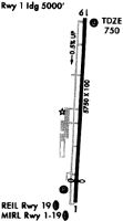
| A81-APT | PAPI RWY 19 OPER DUSK -2200. REIL RWY 19; PAPI RWY 01; HIRL RWY 01/19 OPER DUSK-2200; AFT 2200 ACTVT - CTAF. |
| E147 | TPA FOR LGT ACFT 1041 FT AGL, TPA FOR JET & TURBOPROP ACFT 1541 FT AGL, TPA FOR ULTRALIGHT ACFT 541 FT AGL. |
Runways
Runway Summary
| Runways: | 01/19 |
| Longest Runway: | 01/19 is 5760 ft (1756 m) long |
| Runways with an Instrument Approach: | 19 |
KVPC Airport Runway Details
| Runway 01/19 | 5760 ft x 100 ft (1756 m x 30 m) | |
| Runway Length Source: | 3RD PARTY SURVEY as of 10/10/2018 | |
| Surface: | Asphalt - Excellent condition - Saw-cut or plastic grooved | |
| Runway Edge Lights: | High Intensity | |
Runway Weight Bearing Capacity (in thousands of pounds) |
||
| Single Wheel Landing Gear: | 26.0 | |
Runway 01 |
Runway 19 |
|
Elevation: |
758.6 | 730.7 |
Latitude: |
34-06-54.8946N | 34-07-51.7670N |
Longitude: |
084-50-57.4259W | 084-50-53.2609W |
|
Runway True Alignment: |
003 | 183 |
ILS Type: |
LOC/DME | |
Glide Path Angle: |
3.5 degrees | 3.0 degrees |
Traffic Pattern: |
Left | Left |
Runway Markings Type: |
Nonprecision Instrument | Nonprecision Instrument |
Runway Markings Condition: |
Good | Good |
Object at End: |
TREES | TREES |
Object Height: |
93 | 41 |
Distance from End: |
1324 | 610 |
Object Centerline Offset: |
121 ft. left of centerline | 307 ft. right of centerline |
Visual Glide Slope Indicators: |
2-Light PAPI On Left Side Of Runway | 2-Light PAPI On Left Side Of Runway |
REIL: |
Yes | |
Threshold Crossing Height: |
37 | 44 |
Threshold Elevation: |
754.8 | |
Displaced Threshold: |
740 | |
Threshold Latitude: |
34-07-02.2003N | |
Threshold Longitude: |
084-50-56.8918W |
Services
Airframe Repair: |
Major |
Powerplant Repair: |
Major |
Bottled Oxygen: |
None |
Bulk Oxygen: |
None |
Fuel Available: |
100LL, Jet A+ |
Landing Fees: |
No |
Parking: |
Hangars and tiedowns available |
Other Services: |
Aircraft Cleaning/Detailing |
Maps & Diagrams
KVPC Sectional
Flight Planning
at skyvector.com
at skyvector.com