Location
Latitude: |
33-37-54.1072N (33.631696) |
Longitude: |
085-09-08.1509W (-85.152264) |
Elevation: |
1164.5 feet MSL (355 m MSL) |
Magnetic Variation: |
5 W (as of April 2024 from WMM2020 model) |
Time Zone: |
UTC -5.0 (Standard Time) UTC -4.0 (Daylight Savings Time) |
From City: |
05 N.M. NW of Carrollton, Georgia |
Found On: |
Atlanta Chart |
FAA Region: |
ASO |
Contacts
Manager: |
Publicly owned: |
| SUSAN HEATH 635 REGIONAL AIRPORT ROAD CARROLLTON, GA 30117 770-354-5927 |
WEST GA ARPT AUTH 635 REGIONAL AIRPORT ROAD CARROLLTON, GA 30117 770-354-5927 |
Operations
Airport Status: |
Operational |
Facility Use: |
Public |
Type: |
Airport |
Activation Date: |
10/1970 |
Control tower: |
No |
Attendance (Months/Days/Hours): |
Months/Days/Hours ALL/MON-SAT/0800-1800 |
Boundary ARTCC: |
ZTL (Atlanta) |
Responsible ARTCC: |
ZTL (Atlanta) |
Lighting Schedule: |
SEE RMK |
Segmented Circle Indicator: |
Yes |
Traffic Pattern Altitude (MSL): |
2164 feet (660 m) |
NOTAMs Facility: |
MCN |
NOTAM-D Service: |
Yes |
International Airport of Entry: |
No |
Customs Landing Rights: |
No |
Military Landing Rights: |
Yes |
Civil/Military Joint Use: |
No |
Based Aircraft
| Single Engine: | 106 |
| Multi Engine: | 32 |
| Jet Engine: | 4 |
| GA Helicopters: | 2 |
| Gliders: | 1 |
Annual Operations (as of 12/31/2021)
| Total Operations: | 30000 | |
| GA Local: | 14750 | 49.2% |
| GA Itinerant: | 14750 | 49.2% |
| Military Aircraft: | 500 | 1.7% |
Communications
| CTAF: | 122.975 |
| Unicom: | 122.975 |
| Approach: | ATLANTA 121.0 121.0 121.0 |
| Departure: | ATLANTA 121.0 121.0 121.0 |
| AWOS-3: | 118.175 (770-214-9667) |
Fixed Based Operators (FBOs) & Fuel
(Click on a business for detail)
Please help us keep this information up to date. This is a FREE SERVICE just like everything else on Airport Guide! If you see that a business needs to be added, modified, or deleted please fill out our Update Form.
To add, modify, or delete a business click here.
Please help us keep this information up to date. This is a FREE SERVICE just like everything else on Airport Guide! If you see that a business needs to be added, modified, or deleted please fill out our Update Form.
Area Code: 770 |
| Business Name | Frequency | Phone | Fuel Grade |
|---|---|---|---|
| Carrollton Aviation
Update FBO info |
Unicom 122.7 | 834-0061 | 100LL, Jet A |
Flight Service Stations
| Primary | Alternate | |
| FSS on Field: | N | |
| FSS Name (ID): | Macon(MCN) | |
| Frequency: | ||
| Toll Free Phone: | 1-800-WX-BRIEF |
Instrument Procedures / Charts
FAA Terminal Procedures valid from 0901Z 03/21/24 to 0901Z 04/18/24.
There are various types of charts available for an airport. They are listed in the Page Type column. Here is a legend for those types:
APD - Airport Diagram
DP - Departure Procedure Charts
HOT - Hot Spots
IAP - Instrument Approach Procedure Charts
MIN - Minimums
STAR - Standard Terminal Arrival Charts
| Page Type | Page Name | Volume | Action Since Last Cycle |
|---|---|---|---|
| APD | AIRPORT DIAGRAM | SE-4 | |
| IAP | ILS OR LOC RWY 35 | SE-4 | |
| IAP | RNAV (GPS) RWY 17 | SE-4 | |
| IAP | RNAV (GPS) RWY 35 | SE-4 | |
| MIN | ALTERNATE MINIMUMS | SE-4 | |
| MIN | TAKEOFF MINIMUMS | SE-4 | |
| STAR | DEHAN THREE (RNAV) | SE-4 | |
| STAR | DEHAN THREE (RNAV)[DELIMITER] CONT.1 | SE-4 |
Terminal Procedures are only available for airports in several countries with more being added all the time. If you are looking for a specific country's charts, please send an email to support(at)airportguide.com stating the country name. This will be used to prioritize the implementation.
Navigation Aids (Navaids) near KCTJ
| Dist (NM) | ID | Morse Code | Name | Type | Freq | True Hdg | Mag Hdg |
|---|---|---|---|---|---|---|---|
| 4.1 | GPQ | _ _ . . _ _ . _ _ . _ | Carrollton | NDB | 278 | 165 | 170 |
| 26.8 | FT | . . _ . _ | Flanc | NDB | 344 | 72 | 77 |
| 31.4 | EQQ | . _ _ . _ _ _ . _ | Coweta County | NDB | 234 | 135 | 140 |
| 31.9 | RMG | . _ . _ _ _ _ . | Rome | VORTAC | 115.40 | 2 | 7 |
| 35.1 | LGC | . _ . . _ _ . _ . _ . | Lagrange | VORTAC | 115.60 | 184 | 189 |
| 35.8 | ATL | . _ _ . _ . . | Atlanta | DME | 116.9 | 90 | 95 |
| 36.3 | ATL | . _ _ . _ . . | Atlanta Muni | VOT | 111.00 | 87 | 92 |
| 36.4 | DOB | _ . . _ _ _ _ . . . | Dobbins | TACAN | 113.00 | 61 | 66 |
| 37.0 | GSU | _ _ . . . . . . _ | Atlanta | DME | 116.9 | 89 | 94 |
| 37.4 | EVZ | . . . . _ _ _ . . | Cartersville | NDB | 308 | 24 | 29 |
| 38.8 | FFC | . . _ . . . _ . _ . _ . | Pecat | NDB | 316 | 120 | 125 |
| 39.4 | AN | . _ _ . | Bogga | NDB | 211 | 261 | 266 |
| 42.0 | BR | _ . . . . _ . | Redan | NDB | 266 | 88 | 93 |
| 44.6 | TDG | _ _ . . _ _ . | Talladega | DME | 108.8 | 265 | 270 |
| 45.0 | PDK | . _ _ . _ . . _ . _ | Peachtree | VOR-DME | 116.60 | 70 | 75 |
| 47.5 | OUK | _ _ _ . . _ _ . _ | Calhoun | NDB | 323 | 13 | 18 |
| 49.4 | PIM | . _ _ . . . _ _ | Pine Mountain | NDB | 272 | 163 | 168 |
| 49.8 | DJD | _ . . . _ _ _ _ . . | Chero | NDB | 415 | 41 | 46 |
| 50.8 | GAD | _ _ . . _ _ . . | Gadsden | VOR-DME | 112.30 | 294 | 299 |
| 59.3 | FTP | . . _ . _ . _ _ . | Fort Payne | NDB | 426 | 334 | 339 |
Nearby Airports with Fuel
Notices to Airmen (NOTAMS)
Remarks
| A110-2 | DEER AND TURKEYS ON & NEAR RWYS AT ALL TIMES. |
| A110-3 | FOR APCH/DEP SVC CTC ATLANTA APCH AT 678-364-6131. IF RLS TIME IS EXPD TO BE LESS THAN 5 MINS, CTC CD. |
| A81-APT | HIRL RWY 17/35 PRESET MED INTST DUSK-2200, AFT 2200 ACTVT - CTAF. |
Runways
Runway Summary
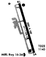
| Runways: | 17/35 |
| Longest Runway: | 17/35 is 5503 ft (1677 m) long |
| Runways with an Instrument Approach: | 35 |
KCTJ Airport Runway Details
| Runway 17/35 | 5503 ft x 100 ft (1677 m x 30 m) | |
| Runway Length Source: | 3RD PARTY SURVEY as of 12/19/2007 | |
| Surface: | Asphalt - Good condition - No special surface treatment | |
| Runway Edge Lights: | High Intensity | |
Runway Weight Bearing Capacity (in thousands of pounds) |
||
| Single Wheel Landing Gear: | 43.0 | |
| Dual Wheel Landing Gear: | 56.0 | |
| Dual Tandem Wheel Landing Gear: | 83.0 | |
Runway 17 |
Runway 35 |
|
Elevation: |
1164.4 | 1110.2 |
Latitude: |
33-38-20.2490N | 33-37-27.9653N |
Longitude: |
085-09-17.2117W | 085-08-59.0901W |
|
Runway True Alignment: |
164 | 344 |
ILS Type: |
LOC/GS | |
Glide Path Angle: |
3.0 degrees | 3.0 degrees |
Traffic Pattern: |
Left | Left |
Runway Markings Type: |
Nonprecision Instrument | Precision Instrument |
Runway Markings Condition: |
Good | Good |
Object at End: |
TREES | TREES |
Object Height: |
26 | 30 |
Distance from End: |
642 | 1040 |
Object Centerline Offset: |
497 ft. left of centerline | 600 ft. right of centerline |
Visual Glide Slope Indicators: |
4-Light PAPI On Left Side Of Runway | 4-Light PAPI On Left Side Of Runway |
Threshold Crossing Height: |
44 | 54 |
Services
Airframe Repair: |
Major |
Powerplant Repair: |
Major |
Fuel Available: |
100LL, Jet A-1+ |
Landing Fees: |
No |
Parking: |
Hangars and tiedowns available |
Maps & Diagrams
KCTJ Sectional
Flight Planning
at skyvector.com
at skyvector.com